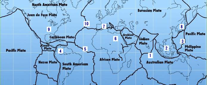
South American Roll Watch
Nancy Wrote on Holgraphic Presentation Last night...
http://www.zetatalk.com/newsletr/issue169.htm
"Over to S America the Andes are shown doing mountain building, while some islands in the Caribbean are sinking, their plate
pushed under as S America rolls."
In this particular Blog will be describes and take note of all the Earth Changes of the World that will lead to the Geological Movement of the South American Plate: about 250 miles/400.33 Km to roll!.
https://poleshift.ning.com/forum/topics/zetatalk-chat-for-december-...
-Caribbean Subducting under Northern South America:
7 of 10 - Safe Locations
https://poleshift.ning.com/profiles/blogs/7-of-10-safe-locations
- Cover, front and back
- Table of Contents and Introduction
- Homeless
- Settlement
- High Tech Note: continued in the next PDF document
- Communities
- Resources
- Addendum
And finally, the Zetatalk predictions for safe locations are 100% accurate.
Tags:
Replies to This Discussion
-
Permalink Reply by Mariaelisa Torres on August 20, 2010 at 5:36am
-
Venezuela August 12 to August 19, 2010 quakes (Map and list)
-
Permalink Reply by Recall 15 on August 24, 2010 at 5:56am
-
Latest quake:

24-AUG-2010 02:12:00 18.87 -107.33 6.1 10.0 OFF COAST OF JALISCO, MEXICO
from:
http://www.iris.edu/seismon/
-
Permalink Reply by Mariaelisa Torres on August 25, 2010 at 2:44am
-
Update Colombia and Venezuela
Colombia daily activity August 23, related to main seismic event in the area of Pasto, Galeras Volcano
Colombia daily activity August 24
Venezuela last 7 days, ending August 24th
Map
Venezuela List past 7 days
-
Permalink Reply by Recall 15 on August 26, 2010 at 6:01am
-
Plate Adjusted:

Lattest Quakes:
25-AUG-2010 12:02:37 -22.70 -68.87 5.0 72.6 NORTHERN CHILE
25-AUG-2010 11:36:39 -27.14 -70.90 4.5 35.1 NEAR COAST OF NORTHERN CHILE
Deep one:
25-AUG-2010 02:35:02 -21.17 -68.91 4.8 122.5 CHILE-BOLIVIA BORDER REGION
From:
http://www.iris.edu/seismon/
-
Permalink Reply by Kojima on August 27, 2010 at 9:49am
-
Periodic motion wave pattern on Honduras has gone.
-
Permalink Reply by Recall 15 on August 27, 2010 at 2:38pm
-
Thanks Kojima, looks that these situation was related to the plate ajusted in panama, at the same time:

from:
http://aslwww.cr.usgs.gov/Seismic_Data/heli2.shtml
@ Fri Aug 27 06:20:07 MDT 2010
From:
http://www.iris.edu/seismon/zoom/?view=eveday&lon=-33&lat=-54
-
Permalink Reply by Recall 15 on August 30, 2010 at 9:03pm
-
When the plate over honduras adjusted @ 08/28, it cause a bridge to start the process of Colapse, on the border of Guatemala and Honduras:
on 08/28:

Then, the debris + trees in the river, finally destroy 50m / 164 feet of the border bridge
on 08/29:

From (Spanish) Link:
http://prensalibre.com/noticias/Colapso-bloquea-acceso-Honduras_0_3...
-
Permalink Reply by Recall 15 on September 6, 2010 at 11:03pm
-
The North of the Caribbean Plate border and South of North American Plate interactions Analysis is here:
http://poleshift.ning.com/forum/topics/guatemala-a-divergent-plate-...
-
Permalink Reply by Recall 15 on September 15, 2010 at 12:05am
-
Thanks Nancy.
Container of PDVSA that had 200,000 barrels of Carburant:

Image from the Smoke on Bonaire:

from:
http://economia.noticias24.com/noticia/32832/pdvsa-reporto-un-incen...
-
Permalink Reply by Recall 15 on September 15, 2010 at 12:31am
-
More of the Bonarie Faults:


These are the 3 scenaries according to this pdf:
http://scholarship.rice.edu/bitstream/handle/1911/20508/1441822.PDF...
-
Permalink Reply by Recall 15 on September 15, 2010 at 4:56pm
-
some quakes:
Interesting Activitie here:
(Pressure Increase):
14-SEP-2010 23:32:02 21.18 -106.16 5.6 36.0 OFF COAST OF CENTRAL MEXICO
14-SEP-2010 10:52:17 32.00 -115.18 5.4 11.5 CALIF.-BAJA CALIF. BORDER REGION
15-SEP-2010 12:29:30 21.14 -106.15 4.9 45.4 OFF COAST OF CENTRAL MEXICO
15-SEP-2010 08:21:28 29.34 -114.36 4.2 10.0 BAJA CALIFORNIA, MEXICO
15-SEP-2010 08:13:42 29.58 -114.19 4.4 10.0 BAJA CALIFORNIA, MEXICO
15-SEP-2010 07:50:08 29.89 -114.09 5.1 10.2 BAJA CALIFORNIA, MEXICO
15-SEP-2010 06:05:49 15.93 -93.07 5.1 96.1 NEAR COAST OF CHIAPAS, MEXICO
From:
http://www.iris.edu/seismon/
SEARCH PS Ning or Zetatalk
Nancy Lieder, Emissary of the Zetas.
https://poleshift.ning.com/xn/detail/3863141:Comment:1168188
Awakening to the Alien Presence ZetaTalk
The truth will likely never to be known to the public but be washed away in the Nibiru panic soon to engulf the world.
The Worst of the Cover-Up
https://poleshift.ning.com/profiles/blogs/the-worst-of-the-cover-up
Main Establishment Lies
https://poleshift.ning.com/profiles/blogs/main-establishment-lies
Donate
© 2025 Created by 0nin2migqvl32.
Powered by
![]()

