South American Roll Watch
Nancy Wrote on Holgraphic Presentation Last night...
http://www.zetatalk.com/newsletr/issue169.htm
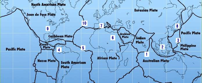
"Over to S America the Andes are shown doing mountain building, while some islands in the Caribbean are sinking, their plate
pushed under as S America rolls."
In this particular Blog will be describes and take note of all the Earth Changes of the World that will lead to the Geological Movement of the South American Plate: about 250 miles/400.33 Km to roll!.
https://poleshift.ning.com/forum/topics/zetatalk-chat-for-december-...
-Caribbean Subducting under Northern South America:
7 of 10 - Safe Locations
https://poleshift.ning.com/profiles/blogs/7-of-10-safe-locations
- Cover, front and back
- Table of Contents and Introduction
- Homeless
- Settlement
- High Tech Note: continued in the next PDF document
- Communities
- Resources
- Addendum
And finally, the Zetatalk predictions for safe locations are 100% accurate.
Tags:
Replies to This Discussion
-
Permalink Reply by Recall 15 on July 28, 2010 at 7:35am
-
These South America roll will be related to the future effect of the activation of the Magnetic Characteristic of the
The Mid Atlantic Rift, by the Magnetic and Gravitational Force of the near Brown Dwarf knows as Nibiru, it will rips the Middle Atlantic Ocean Floor, and somehow great part of the water will be equalized and sended to Europa, but some part of the Ocean will be redirected by the Sea Floor topography in front and Behind of the Middle Atlantic Ocean to all the near continents Coasts, and it will generate Tsunamis there too.
Quoted:
"Major Areas that will experience near total or absolute devastation over time due to Atlantic Tsunamis:
...Most cities within 100 miles of the coastline bordering both sides of the Atlantic ..."
End quoted:
For a Further understanding of this event, please go to Grant´s Website:
http://www.grantchronicles.com/astro119.htm
-
Permalink Reply by Recall 15 on July 29, 2010 at 3:39am
-
Some Seismic Activity on Central America and Panama:
28-JUL-2010 12:22:25 4.77 -82.55 4.5 10.6 SOUTH OF PANAMA
26-JUL-2010 02:18:38 13.56 -90.64 4.5 66.8 NEAR COAST OF GUATEMALA
23-JUL-2010 14:03:38 7.30 -77.12 4.6 49.0 PANAMA-COLOMBIA BORDER REGION
19-JUL-2010 01:51:34 11.91 -86.99 4.5 84.0 NEAR COAST OF NICARAGUA
16-JUL-2010 00:06:45 12.92 -88.47 4.9 81.0 OFF COAST OF CENTRAL AMERICA
From:
http://www.iris.edu/seismon/zoom/events/?lon=-82.55&lat=4.77
-
Permalink Reply by Recall 15 on July 30, 2010 at 9:33pm
-
a quake on Nicaragua:
30-JUL-2010 14:41:28 11.59 -86.65 5.0 96.1 NEAR COAST OF NICARAGUA
http://www.iris.edu/seismon/zoom/events/?lon=-86.72&lat=11.63
-
Permalink Reply by Recall 15 on July 31, 2010 at 7:48pm
-
activity on Ascension Island.
31-JUL-2010 11:36:56 -0.73 -15.98 5.4 10.4 NORTH OF ASCENSION ISLAND

http://www.iris.edu/seismon/zoom/events/?lon=-15.98&lat=-0.73
-
Permalink Reply by Recall 15 on August 1, 2010 at 1:09am
-
some graphs on Liss:
http://aslwww.cr.usgs.gov/Seismic_Data/heli2.shtml
Some sort of Wave on periodic motion in Honduras (The border of the Caribbean Plate is rising?):
and some activity near Guatemala
31-JUL-2010 05:15:13 13.48 -90.48 4.8 76.3 NEAR COAST OF GUATEMALA
from:
http://www.iris.edu/seismon/zoom/events/?lon=-90.48&lat=13.48
Plate ajusting in Norway?

The Bow in Tucson ?

And more activity in Venezuela

-
Permalink Reply by Kojima on August 1, 2010 at 2:01am
-
I haven't seen the wave pattern, periodic motion, shown at Honduras till now. Attention is necessary.
-
Permalink Reply by Recall 15 on August 1, 2010 at 2:45am
-
Right is very interesting, it show the movement of the plate...
Direct Link:
http://aslwww.cr.usgs.gov/Seismic_Data/telemetry_data/TGUH_24hr.html
in 1 hour or less it will be actualized to the new page... of 08-01-2010
Some data from Costa Rica Central America:
http://www.ovsicori.una.ac.cr/sismologia/sismogramas_linea.htm
2010-07-31 09:19:00 3.2 14 11 km NE of San isidro Coronado 10.0442 -83.9411
Earlier:
2010-07-29 08:31:00 4.1 25 8 km Nor West of San Vito de Coto 8.884 -82.989
2010-07-28 15:51:00 4.3 15 15 km South of Golfito 8.5264 -83.2293
2010-07-27 07:00:00 3.4 5 5 km Nor Este of Volcano Irazu 9.979 -83.819
2010-07-27 09:00:00 3.3 24 10 km Nor Oeste of Nicoya 10.217 -85.501
-
Permalink Reply by Recall 15 on August 1, 2010 at 8:14am
-
back to Honduras:
Data from station TGUH (Tegucigalpa, Honduras)
last updated at
Sun 08/01/10 00:08 MDT (Sun 08/01/10 06:08 GMT)

Anomalies continues...
-
Permalink Reply by Recall 15 on August 1, 2010 at 8:28am
-
Some data regarding the Northwestern Caribbean Plate:

Quote:
"Geologic and Bathymetric Setting of the Honduran
Borderlands GEOSAT (geodetic satellite) marine gravity data compiled shows the large-scale basement structure of the Honduran borderlands. To the north of the borderlands, the Cayman trough shows a large gravity low associated with thin oceanic crust produced at the Mid-Cayman spreading center between 49.3 and 0 Ma (Leroy et al., 2000). A gravity high is centered on the active spreading center of the short, 100-km-long spreading center. The Nicaragua carbonate platform, located south of the Honduran borderlands, is characterized by a smooth gravity high.The Honduran borderlands exhibits a disrupted gravity field(Gorsline and Teng, 1989). Twin gravity highs or
produced by the existence of elongate, fault-bounded, marginparallel basins and ridges characteristic of continental borderland provinces
basement ridges extend along the southern, faulted margin of the Cayman trough while a gravity low basin extends along the edge of the Nicaragua Rise. A gravity or basement high, the Patuca Ridge, is present within this basinal structure and projects into the Nombre de Dios range of northern Honduras. The southern part of the Patuca Basin projects into the Aguan Valley."
end quoted from pdf file:
http://geology.csustan.edu/rrogers/pub/spe428-03.pdf
SEARCH PS Ning or Zetatalk
Nancy Lieder, Emissary of the Zetas.
https://poleshift.ning.com/xn/detail/3863141:Comment:1168188
Awakening to the Alien Presence ZetaTalk
The truth will likely never to be known to the public but be washed away in the Nibiru panic soon to engulf the world.
The Worst of the Cover-Up
https://poleshift.ning.com/profiles/blogs/the-worst-of-the-cover-up
Main Establishment Lies
https://poleshift.ning.com/profiles/blogs/main-establishment-lies
Donate
© 2025 Created by 0nin2migqvl32.
Powered by
![]()


