South American Roll Watch
Nancy Wrote on Holgraphic Presentation Last night...
http://www.zetatalk.com/newsletr/issue169.htm
"Over to S America the Andes are shown doing mountain building, while some islands in the Caribbean are sinking, their plate
pushed under as S America rolls."
Note:
In this particular Blog will be describes and take note of all the Earth Changes of the World that will lead to the Geological Movement of the South American Plate: about 250 miles/400.33 Km to roll!.
https://poleshift.ning.com/forum/topics/zetatalk-chat-for-december-...
In this particular Blog will be describes and take note of all the Earth Changes of the World that will lead to the Geological Movement of the South American Plate: about 250 miles/400.33 Km to roll!.
https://poleshift.ning.com/forum/topics/zetatalk-chat-for-december-...
" These regions will not experience the sense that they have moved 250 miles further to the west, though this will be computed by man after the roll has been completed."
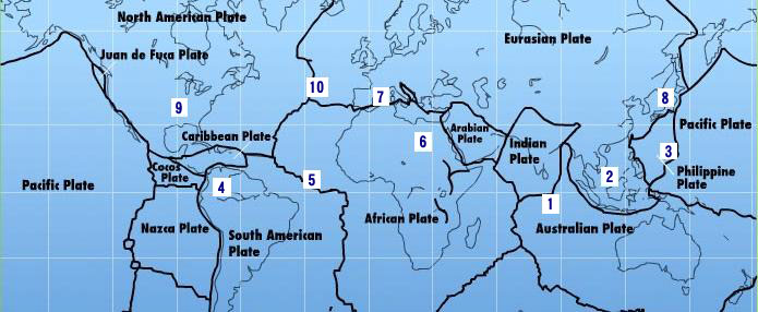
The 7 of 10 Event: A multi-region event!
The Zeta sequence is as follows:
(2) with Indonesia sinking,
(3) a folding Pacific Ocean
Allowing:
(4) S America to roll,
-this blog-
-Caribbean Subducting under Northern South America:
-Sinking part of the Caribbean Plate:
-Lesser Antilles sinks in the ocean and
-Central America get crunched in the process:
(5) a tearing of the south Atlantic Rift
Allowing:
(6) Africa to roll
(8) great quakes in Japan:
-Precursor:
(9) followed by the New Madrid adjustment,
(10) which is followed almost instantly by the tearing of the north Atlantic Rift with consequent European tsunami.
7 of 10 - Safe Locations
https://poleshift.ning.com/profiles/blogs/7-of-10-safe-locations
7 of 10 Pace:
8 of 10 Overlap:
A Must See:
Zeta Report Survival Tips 1:
Zeta Report Survival Tips 2:
Zetatalk/Troubled Times Survival Booklet PDF:
- Cover, front and back
- Table of Contents and Introduction
- Homeless
- Settlement
- High Tech Note: continued in the next PDF document
- Communities
- Resources
- Addendum
And finally, the Zetatalk predictions for safe locations are 100% accurate.
PDF File:
All data is Cited, Quoted, Credited and Linked to Their respective Originators.
Note Also that no data Before: July 21, 2010 at 6:07pm ET of this TimeWorld is Displayed!
Tags:
Replies to This Discussion
-
Permalink Reply by Mariaelisa Torres on August 2, 2010 at 8:27am
-
Venezuela, last seven days seismicity ending August 1, 2010
-
Permalink Reply by Recall 15 on August 4, 2010 at 2:40pm
-
Some activitie on Jujuy , Argentina
04-AUG-2010 04:24:36 -23.84 -66.52 5.3 177.3 JUJUY PROVINCE, ARGENTINA
from:
http://www.iris.edu/seismon/zoom/events/?lon=-66.52&lat=-23.84
-
Permalink Reply by Recall 15 on August 5, 2010 at 7:33am
-
Some buoys in the Pacific Ocean: - South America-


-
Permalink Reply by Recall 15 on August 5, 2010 at 3:01pm
-
Some activitie in Americas Continents:
05-AUG-2010 00:04:18 43.65 -110.28 4.8 5.0 WYOMING
05-AUG-2010 09:20:45 18.26 -101.06 4.3 85.5 GUERRERO, MEXICO
05-AUG-2010 04:52:48 -17.08 -70.29 4.7 93.4 NEAR COAST OF PERU
05-AUG-2010 06:38:50 -37.49 -73.54 4.7 25.7 NEAR COAST OF CENTRAL CHILE
05-AUG-2010 06:27:16 -37.43 -73.37 5.2 24.9 NEAR COAST OF CENTRAL CHILE
From:
http://www.iris.edu/seismon/
-
Permalink Reply by Recall 15 on August 6, 2010 at 11:44pm
-
and From Iris:

06-AUG-2010 17:27:30 18.69 -107.49 4.0 29.8 OFF COAST OF JALISCO, MEXICO
06-AUG-2010 17:33:51 10.85 -86.15 4.6 43.0 OFF COAST OF COSTA RICA
06-AUG-2010 17:39:31 33.98 -116.45 4.0 3.2 SOUTHERN CALIFORNIA
-
Permalink Reply by Recall 15 on August 7, 2010 at 3:38am
-
Laurie, this depend of the Scale used to measure the movement:
ie:
Quote:
" "The Richter magnitude scale, also known as the local magnitude (ML) scale, assigns a single number to quantify the amount of seismic energy released by an earthquake. It is a base-10 logarithmic scale obtained by calculating the logarithm of the combined horizontal amplitude (shaking amplitude) of the largest displacement from zero on a particular type of seismometer (Wood–Anderson torsion). So, for example, an earthquake that measures 5.0 on the Richter scale has a shaking amplitude 10 times larger than one that measures 4.0. The effective limit of measurement for local magnitude ML is about 6.8. The Richter scale has been superseded by the moment magnitude scale, which is calibrated to give generally similar values for medium-sized earthquakes (magnitudes between 3 and 7). Unlike the Richter scale, the moment magnitude scale is built on sound seismological principles, and does not saturate in the high-magnitude range. Magnitudes are still widely stated on the Richter scale in the mass media, although usually moment magnitudes—numerically about the same—are actually given "
from:
http://en.wikipedia.org/wiki/Richter_magnitude_scale

-
Permalink Reply by Recall 15 on August 7, 2010 at 3:43am
-
Also:
The Mercalli Scale
Quoted:
"The lower degrees of the Modified Mercalli Intensity scale generally deal with the manner in which the earthquake is felt by people. The higher numbers of the scale are based on observed structural damage. The table on the right is a rough guide to the degrees of the Modified Mercalli Intensity scale. The colors and descriptive names shown here differ from those used on certain shake maps in other articles. The table on the left gives Modified Mercalli scale intensities that are typically observed at locations near the epicenter of the earthquake."
from:
http://en.wikipedia.org/wiki/Mercalli_scale


-
Permalink Reply by Recall 15 on August 9, 2010 at 8:10pm
-
and on Panama Area:
09-AUG-2010 04:32:18 6.30 -82.60 4.2 10.0 SOUTH OF PANAMA
from:
http://www.iris.edu/seismon


from Liss:
http://aslwww.cr.usgs.gov/Seismic_Data/heli2.shtml
-
Permalink Reply by Recall 15 on August 12, 2010 at 11:09pm
-
well. iris is Back:
The Quake on Ecuador:

12-AUG-2010 11:54:14 -1.27 -77.37 7.1 189.9 ECUADOR
and the one on Central Peru:
12-AUG-2010 01:24:19 -11.99 -72.31 5.0 43.2 CENTRAL PERU
-
Permalink Reply by Recall 15 on August 12, 2010 at 11:29pm
-
And not on Iris Database!
The 4.4 Quake on Guatemala @ 08122010 6.04 local Time
http://prensalibre.com/noticias/comunitario/sismo-retalhuleu-san_ma...
-
Permalink Reply by Mariaelisa Torres on August 13, 2010 at 4:46am
-
Ecuador Map of quakes and list of quakes for August 12, 2010
SEARCH PS Ning or Zetatalk
Donate
© 2025 Created by 0nin2migqvl32.
Powered by
![]()

