South American Roll Watch
Nancy Wrote on Holgraphic Presentation Last night...
http://www.zetatalk.com/newsletr/issue169.htm
"Over to S America the Andes are shown doing mountain building, while some islands in the Caribbean are sinking, their plate
pushed under as S America rolls."
In this particular Blog will be describes and take note of all the Earth Changes of the World that will lead to the Geological Movement of the South American Plate: about 250 miles/400.33 Km to roll!.
https://poleshift.ning.com/forum/topics/zetatalk-chat-for-december-...

-Caribbean Subducting under Northern South America:
7 of 10 - Safe Locations
https://poleshift.ning.com/profiles/blogs/7-of-10-safe-locations
- Cover, front and back
- Table of Contents and Introduction
- Homeless
- Settlement
- High Tech Note: continued in the next PDF document
- Communities
- Resources
- Addendum
And finally, the Zetatalk predictions for safe locations are 100% accurate.
Views: 92202
Replies to This Discussion
-
Permalink Reply by Mariaelisa Torres on
-
Quakes reach the Venezuelan Andes at "sensed and unable to downplay" intensities. Bogota (Colombia) area also felt a similar intensity tremor
Earthquake of 5.0 degrees was recorded this morning in San Cristobal (TACHIRA)
13/05/2011 24:04 The governor of Tachira, Cesar Perez Vivas, told the news channel Globovision that until now no reported casualties or infrastructure damage.
The quake struck at 10:48 am this viernesFoto: Courtesy
PUERTO LA CRUZ .- The Venezuelan Foundation of Seismological Research (Funvisis) reported via Twitter (@ FUNVISIS) a 5.0 magnitude earthquake 125 kilometers from the city of San Cristobal, Tachira state.
The quake occurred at 10:48 am.
The governor said Cesar Perez Vivas Globovisión news channel that until now no reported casualties or infrastructure damage.
He noted that members of the state fire department and Civil Protection evaluated the area where he felt the earthquake to determine if there was damage.
In the morning there was also an earthquake of magnitude 4.9 in northeastern Colombia. The tremor was felt in Bucaramanga and Cucuta, near the border with Venezuela.http://www.diariosyperiodicos.com/america_del_sur/venezuela/anzoate...
While the movement 7 of 10 that is sinking Margarita, shows in Anzoategui (cause it ping-pong here too with quakes in the Andes to West while Anzoategui to EAST) events like this happen:
Two killed, 20 injured by falling power lines in Guanipa
13/05/2011 9:15 a.m. The incident occurred this morning in the Rómulo Gallegos sector of the southern town of Anzoátegui. 11 of the injured were detained in a hospital.
Web Writing / Marinela Marcano
A bed was completely burned in a house afectadasFoto: Marinela Marcano
PUERTO LA CRUZ .- Two people died early this morning to drop a high voltage cables over 28 Rómulo Gallegos sector housing in the municipality Guanipa San Jose, Anzoátegui state.
The incident, which occurred at about one o'clock in the morning, also left 20 people injured, of which 11 were transferred to the municipal hospital.
Group of neighbors upset by the fact, took Corpoelec headquarters in the area to require more monitoring and maintenance to the electrical system in the community.
Regional police arrived to talk with the protesters and reach an agreement.
The affected area was the mayor of Guanipa, Pedro Martinez, accompanied by officials of the National Electricity Corporation to assess the damage.
Martinez reported that the Mayor's Guanipa every support to Corpoelec to assume the expenses of the families of the deceased.
She also indicated that there will be a census to subsidize those who lost most of its appliances to the accident.
Rómulo Gallegos sector is guarded by policemen of Anzoátegui state, National Guard and PoliGuanipa agents.
Corpoelec technical team is working to determine the origin of the fault.http://www.diariosyperiodicos.com/america_del_sur/venezuela/anzoate...
-
-
COSTA RICA 6.0 Preliminary
Reportes del OVSICORI indican 70 km de prof. y 6.0 grados
But twitters say
Última hora fuerte sismo: El sismo tuvo una profundidad de 45 kilómetros
-
Permalink Reply by Recall 15 on
-
Mariaelisa Torres said:
COSTA RICA 6.0 Preliminary
Reportes del OVSICORI indican 70 km de prof. y 6.0 grados
But twitters say
Última hora fuerte sismo: El sismo tuvo una profundidad de 45 kilómetros
I got this:
2011-05-13 22:47:55 UTC Mag: 6.37 58 0 km al Sur de Alajuela
-
-
Then Ping Pong Quake Effect:
13-MAY-2011 23:35:53 37.38 141.41 6.2 37.6 NEAR EAST COAST OF HONSHU, JAPAN
13-MAY-2011 22:47:55 10.11 -84.26 6.0 70.0 COSTA RICA
ocurrence of a Pair of Quakes Response @
America Vrs Polynesia : 47 min 58 secFrom:
-
-
Caribbean Plate Border:
British Virgin Islands: Flash flooding is a very dangerous situation.
Read More:
http://poleshift.ning.com/profiles/blogs/british-virgin-islands-flash
-
-
Caribbean Plate Border:
Panama: The main street of Punta Pacifica was another place that was completely flooded.
Read More:
http://poleshift.ning.com/profiles/blogs/panama-the-main-street-of
-
-
BOLIVIA: LA PAZ MEGASLIDES CONTINUES
It began back in February, and now it reached the CERVEZERIA (The beer factory)
Back in February-March-April, crawling through a mountain, diagonally from south East to North West, as we move west. to the right of the river it started, crossed the river taking a sanatorium and a private school located on the left
This is the view of its crossing the river
From the collapse of the Da Vinci Private school taken from a video, note the yellow house way back in the picture here
http://hsjd.org/noticia.php?id=293
So it continued towards the yellow house on the top of the hill, this is not a low income house, it is a mansion, note the mountain next to the mansion, cracking open, on its way to the other side of the mountain
As observed in this map, it started in the circle,
http://boliviaexterior.com/seccion/3-social/noticia/3831-Avanza_mov...
And the news dated May 12 yesterday, reported in the news May 13, the evacuation of the Cerveceria, which is where the 3 dots North WEST of the original circles are: low circle is Pampanasi Bajo (it took town houses and people cried asking for mortgage condoned); the center red circle says Metropolitan, and the upper one is CERVECERIA
La Paz, Bolivia - 05/13/2011 11:34 p.m.
The mayor can not get families to leave their homes despite the risk
Cerveceria asked to leave the sector to stabilize
DEMAND Bs 8 million common destiny for the tasks of stabilization and construction of drainage, but requires that families abandon their homes in the area.
Page Seven / La Paz - 12/05/2011The central road of the neighborhood sunk.
The Mayor of La Paz announced yesterday that it has everything ready to begin work to stabilize La Cerveceria area, located east of the city, but this family needs at least 22 houses out of business suffered cracks.
"All coordination efforts have been made with the neighbors have not been able to achieve. They are reluctant to leave, but we as a Risk Management have set the project to stabilize La Cerveceria area. We are waiting for evacuation to work, "the special director of Risk Management of the commune, Vladimir Toro.
There are eight million Bolivians to stabilize the sector, "eliminating the weight (houses) and creating a drainage system to drain rainwater and groundwater as well as other jobs that will give security to other homes in this area," he said.
The Mayor insists on negotiating the evacuation of 22 homes at risk of collapse, but if agreement is possible, there is no alternative but to "enforce the law", ie call the police to prevent personal injury in the neighborhood. "Since September has been insisting on the need to evacuate the homes that are in a high risk of slipping and we will continue all efforts to reach agreements, but if that is not possible, you must apply the law "said Mayor Luis Revilla.
In September 2010, the district warned of imminent risk of sliding La Cerveceria sector and promised to neighboring homes. To date no progress in the process and the land is receding. Even the mayor asked, in October 2010 - the Ministry of Public Works which victims are included in a housing plan. But the mayor proposal was rejected by the neighbors who ask expropriation of their lands.
The Director of Planning Coordination, Fabian Sinani, reported that the soil movement doubled in the last week of 2.5 to two centimeters and that it is about 90 centimeters of vertical rejection, despite a number of filled jobs in the area La Cerveceria. (LE)Stabilization project in the area
The Labour mayor plans to eliminate the overhead of the top of the 22 houses collapsing area at risk of collapse. Then build a drainage system to drain rainwater and groundwater. In addition, there will be other jobs that will give security to other homes in this area.
The Mayor's budget allocated eight million Bolivians to carry out stabilization works in the brewery sector. Risk Director, Vladimir Toro said they can intervene immediately, however, work may not start if the houses are still inhabited.
Six million Pampahasi Under
The Mayor is planning to invest six million Bolivians to stabilize Pampahasi Low, where the crown of the east slope megadeslizamiento.
The portfolio aims to prevent further cracks to the court Venus. This will build infiltration galleries, curtains drainage, retaining walls will change the water and sewer system, and carried out earthworks at the head of the landslide.
The special risk director, Vladimir Thomas, said all these projects require an investment of five to six million Bolivians. He reported that the Mayor plans to start work in late May and completed before the rainy season.
"These works will make the control of groundwater, rain (rain) and health (housing)," said Toro.
Regarding the disaster area and stabilized the lower Valley of Flowers "B". Terracing was the sector with ten shoulders or steps.
In two of Callapa sector, on top of the district are working on the extraction of groundwater and Jokoni was constructed more berms. Also closed cracks in all sectors of Callapa.
http://www.prensaescrita.com/adiario.php?codigo=BOL&pagina=http...I think the megaslide is a mirror image of the movement we are doing, considering Nancy-Zeta's observation that this continent is locked in the lower tip. Considering the quakes in Costa Rica, Colombia and the Andes of Venezuela, the megaslide reaching 90 centimeters at the Cerveceria, is no surprise.
-
-
Colombia: The canoes have become the indispensable means for the people of Puerto Cordoba.
Read More:
http://poleshift.ning.com/profiles/blogs/colombia-the-canoes-have
-
-
More on Rain and flooding by Nancy and Zetatalk:
Quoted:
" There is a lot of flooding that is due simply to heavy rain, some exacerbated by land sinking, and other places where the coastline has definitely sunk. Can you help us sort this out? What is the cause of the unusually heavy rains being experienced in some areas?
SOZT
Rain and flooding from rain has obviously been chosen by heads of state as the prevailing excuse for the Earth changes predicted by ourselves, the Zetas. From Indonesia to the Caribbean to S America reports of rain have been inserted into almost every report of sudden or unusual flooding. In Indonesia the press dutifully inserted the “rain” excuse or found some citizen to quote, and only after several months when rebellion set in they began to say “allegedly rain” and the like. Now the press is reporting how LONG the water has been standing, finally doing their job. In the Caribbean, islands that are in the zone we predicted would be first hit by the tipping and sinking Caribbean are again blaming rain even when the rain charts show a fraction of an inch as the cause. In S America the horrific flooding in Colombia and western Venezuela and in Brazil where the bending continent is being distorted is again being blamed on rain, which certainly was there to some degree, but the press is avoiding a careful analysis of just WHERE the flooding is occurring. If it occurs in this river valley but not downstream, then the water is being held back in some way by a heaving river bottom.
In these matters it is up to the reader to discern, as the press is being leaned on, the editors TOLD what to allow. No speculation! Stick with the conservative answer, the traditional answer, which is rain. Nancy and the ning have done their best trying to sort through the reports to prove the issue, which is a lot of work. It would be even more work to do a historical search of flooding reports, to show a pattern of an increase and tenacity. What is really needed for the world to understand what is happening is for an investigative reporter, or concerned citizen, to poll the sites under water. They could determine how LONG this has been the case, to determine the depth of the water, and to determine the elevation of the site. Lacking this, it will likely be months before an honest report about the flooding in Indonesia comes out, as was the case in Pakistan in the Indus Valley when they lost a mere 10 feet in elevation. The truth may come out in incidental comments, as the Earth changes increase and move to S America and Africa, where the Earth changes will be harder to burry under the rain excuse.
EOZT"end quoted
from:
http://poleshift.ning.com/forum/topics/zetatalk-chat-for-may-14-201...
-
-
Mountain formation and or earth changes that loosen the soil, as explained by Zetas through Nancy, wash debris, soil, rocks when it rains. The entire territory is wet by rains. The Tachira-Merida and Trujillo mountains provide a lot of soil in the form of mud to our water supply. Thus, the following news are making the headlines, because pipes are breaking, and water treatment plants cannot clean the mud, and must wait for it to settle.
May 14, 2011
Municipalities of Barinas Falcon and without drinking water due to rainfall
The swollen river in the municipality Cacique Tocuyo Manaure, caused by heavy rains, caused a split in the pipe of the aqueduct that supplies drinking water to the population of Yaracal. Esteban Rodriguez, Hidrofalcón, explained that the fault was generated in Corralito sector, after a lot of debris and sediment-entrained by the flow of the river, provoke the detachment of the attachment that holds the pipe causing damage to the adduction line. It is providing the liquid to the neighbors through tankers. Rationing will be implemented.
In Barinas restrict service
In Barinas rains raised a measure of restriction of water service. The sectors affected are sixty, roughly representing 70% of Barinas population receiving water supply, water treatment plant located in the north of the city.
Trujillo Alert
Civil Protection are on alert in Trujillo state due to persistent rainfall in many areas of the company, said Friday the state coordinator for PC, Jose Moreno. "This afternoon rains have occurred in the Pan-American axis (municipalities Miranda, La Ceiba, Andrés Bello, Monte Carmelo, Sucre) and it is expected that the night will be stronger. " (LSN)
http://www.el-carabobeno.com/impreso/articulo/t140511-sl05/municipi...
-
-
More info regarding the Caribbean Plate Borders by Nancy and Zetatalk Newsletter 241 Sunday May 15 2011
Quoted:
"
Caribbean Borders
The S American roll is poised and ready, which can be seen by where disasters are occurring. Curiously clustering around May 3, for instance. Did the roll press forward on that date? These disasters outline the borders of the Caribbean Plate and go down along the N Andes Fault Line. Starting at Guatemala, where the rainy season began but do note that the first flush of flooding has started just on the Caribbean border where it cuts through Guatemala, and nowhere else! WeatherUnderground indicates thunderstorms but no measureable precipitation. Why did it flood just in Puerto Barrios?
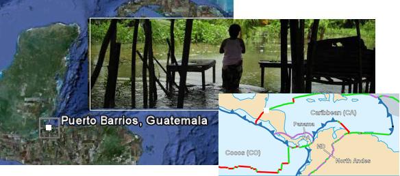
- Torrential Rains Leave 2,390 Affected in the Guatemalan Caribbean
May 03, 2011
http://www.aguasdigital.com/actualidad/leer.php?idnota=3818454&efenew=1 - It rained hard for five hours in Izabal which increased the river flow Escondido brought down the drains in the urban area of the city of Puerto Barrios. The rainy season began in 2011, which lasts until October. In mid-May is scheduled to open in rainfall in the central plateau, which includes the capital, while on the Pacific coast will be the end of the month, and in the north at the beginning of June.
Moving across the northern border of the Caribbean Plate we encounter the Dominican Republic where a mere 80 mm (.31") of rain brings an odd flash flood and warnings of "abnormal waves". This would be the case if the Caribbean Plate had tilted slightly, as the Dominican Republic is on the northern lip of the Caribbean Plate. Again, the date is May 3. And yet again on this date, a sinkhole opened up on the island of Barbados, one of the islands cited by the Zetas to have significant elevation loss during the S American roll. Barbados does have sea caves along its coastline, so a sinkhole would not be surprising if the rock is squeezed from the side and pushed down.
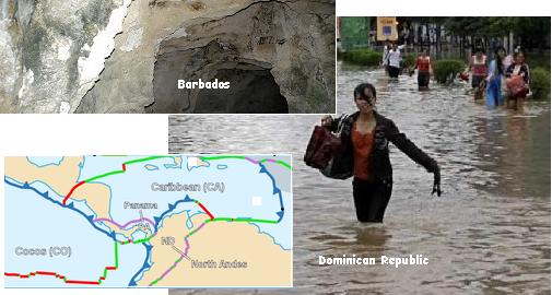
- Dominican Republic: Flash Flood Warning Issued in High-Risk Areas
May 3, 2011
http://encarpeta.net/noticia.php?id_noticia=778&sesion_periodico=55 - It is expected that the cumulative rainfall in the next 24 hours could exceed 80 mm, causing urban flooding. As sea conditions in the Atlantic and Caribbean coasts, fragile and small vessels should navigate with caution near the coast and not to venture offshore by waves abnormal.
- Sinkhole Opens up in Barbados
May 3, 2011
http://news.caribseek.com/Barbados/Daily_Nation/article_93237.shtml - Since late last year the yard started cracking up, then the back step started shifting, or rather moving out of place. The hole seemed very deep.
Then along the top of Venezuela, where the border with the Caribbean Plate skirts along. In Barlovento, La Victoria, Merida, and Vargas flooding occurred on that fateful day, May 3. But the crumbling along the plate edge can create blockages in rivers and streams, funneling water in unexpected directions. Merida is also right on the N Andes Fault Line.
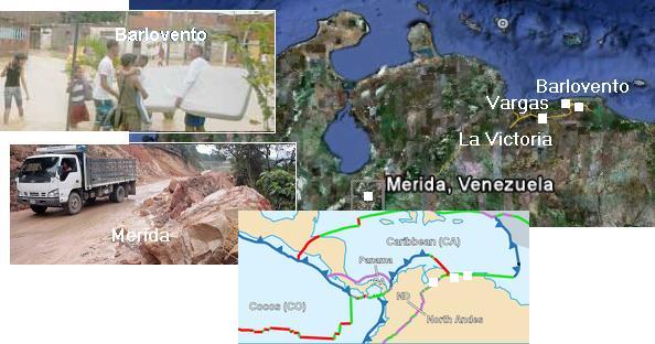
- New Flood in Barlovento
May 03, 2011
http://www.diariolavoz.net/seccion.asp?pid=18&sid=438¬id=360547 - Floods, landslides, slope, landslides, collapse of houses, roads blocked by logs and debris carried by the stream, are the product of the heavy rain still falling in the area of Barlovento, Miranda state.
- Civil Protection cleared the highway again Valencia-Puerto Cabello
May 3, 2011
http://www.eluniversal.com/2011/05/03/242-viviendas-afectadas - 242 homes were flooded after the Aragua river flooded. The level of water accumulated in the streets reached up to one meter in height. Also reported in the pediatric emergency contingency Hospital in the city of La Victoria, due to the entry of water, a situation that limited medical services for several hours.
- Mocotíes River Left a Woman Dead in Merida
May 3, 2011
http://www.eluniversal.com/2011/05/03/aguas-del-rio-mocoties - The downpour caused severe damage to roads, hundreds of homes and other infrastructure. Rainfall has claimed the life of a woman. She slipped and fell into the river Mocotíes, being washed away by raging waters about 3 miles.
- Harold Flores was Swept Away by the Floodwaters
May 3, 2011
http://www.eluniversal.com/2011/05/03/un-desaparecido - The most critical situation was on the east coast, rivers overflowed Guayabal, Chuspa and La Sabana, landslides were impeding the Road Coast, and was reported as missing a vacationers.
If the Caribbean Plate moved on May 3, the N Andes Fault Line has been consistently active. On the fault in Colombia, roads are twisted and heaving river bottoms, dammed the rivers and sending water in new directions. In Ecuador at Quito, also on the fault, a horrific landslide occurred. If floods and landslides and sinkholes are all that common in the region, then why are they just occurring on the plate borders or fault lines?
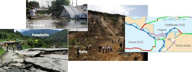
- Shattered Road in Pamplonita
April 28, 2011
http://www.laopinion.com.co/noticias/index.php?option=com - From Easter began to evince a geological fault collapsed a considerable stretch of road. Many landslides are on the road and down hills water jets that resemble waterfalls or streams.
- Increase to 14,300 Affected Families
April 29, 2011
http://www.eluniversal.com.co/cartagena/bolivar/aumentan-14300 - The official said that the emergency is almost immeasurable, and warns that the rapidly growing number of people affected due to floods do not stop.
- Landslide in Quito Killing 5 People
May 5, 2011
http://www4.elcomercio.com/2011-05-02/Noticias/Quito/Noticia - New landslide occurred in the prospectus, Simon Bolivar. At the moment, confirmed the death of five people. Four of the victims belong to the family of Machachi. Husbands Jorge Askel and Mary Magdalene Cañizares, along with his son Miguel Askel, drove past in a red wagon, when the mountain collapsed.
"
end quoted
from:
http://www.zetatalk.com/newsletr/issue241.htm
- Torrential Rains Leave 2,390 Affected in the Guatemalan Caribbean
-
-
Tolima, Cajamarca Colombia
The way to Alto de La Línea is blocked, emergency avalanche Cajamarca
By: EDITORIAL TOLIMA | 1:14 p.m. | May 14, 2011
At least 3 landslides blocked the road toAlto de La Línea, in Tolima.
The problem arises between Cajamarca and Calarcá so many vehicles remain dammed on either side of the road.
"It rained all night and the water generated by this emergency, " said Cesar Augusto Gutierrez, director of the emergency committee of Tolima. Invías added that staff is working to enable the road in the afternoon.
The rains also hit the village of Anaime, in Cajamarca. In this agricultural area avalanche swept Anaime River with about 20 homes.
"There are no victims, they are only material damage but we have a high number of homeless families, " said the director of the emergency committee.
He noted that the flood destroyed bridges and caused major damage in the road so there is no communication.
"The river took cows, chickens, pigs and all kinds of animals, " said Marco Gonzalez, a farmer who lost his home.
"We were on the street and ask for help now, we need food and blankets to shelter us, "the victim.
EDITORIAL TOLIMA
http://www.eltiempo.com/colombia/tolima/derrumbes-en-la-via-la-line...
© 2025 Created by 0nin2migqvl32.
Powered by
![]()