South American Roll Watch
Nancy Wrote on Holgraphic Presentation Last night...
http://www.zetatalk.com/newsletr/issue169.htm
"Over to S America the Andes are shown doing mountain building, while some islands in the Caribbean are sinking, their plate
pushed under as S America rolls."
Note:
In this particular Blog will be describes and take note of all the Earth Changes of the World that will lead to the Geological Movement of the South American Plate: about 250 miles/400.33 Km to roll!.
https://poleshift.ning.com/forum/topics/zetatalk-chat-for-december-...
In this particular Blog will be describes and take note of all the Earth Changes of the World that will lead to the Geological Movement of the South American Plate: about 250 miles/400.33 Km to roll!.
https://poleshift.ning.com/forum/topics/zetatalk-chat-for-december-...
" These regions will not experience the sense that they have moved 250 miles further to the west, though this will be computed by man after the roll has been completed."
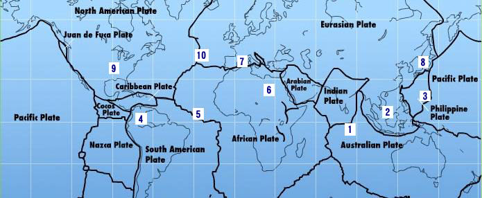
The 7 of 10 Event: A multi-region event!
The Zeta sequence is as follows:
(2) with Indonesia sinking,
(3) a folding Pacific Ocean
Allowing:
(4) S America to roll,
-this blog-
-Caribbean Subducting under Northern South America:
-Sinking part of the Caribbean Plate:
-Lesser Antilles sinks in the ocean and
-Central America get crunched in the process:
(5) a tearing of the south Atlantic Rift
Allowing:
(6) Africa to roll
(8) great quakes in Japan:
-Precursor:
(9) followed by the New Madrid adjustment,
(10) which is followed almost instantly by the tearing of the north Atlantic Rift with consequent European tsunami.
7 of 10 - Safe Locations
https://poleshift.ning.com/profiles/blogs/7-of-10-safe-locations
7 of 10 Pace:
8 of 10 Overlap:
A Must See:
Zeta Report Survival Tips 1:
Zeta Report Survival Tips 2:
Zetatalk/Troubled Times Survival Booklet PDF:
- Cover, front and back
- Table of Contents and Introduction
- Homeless
- Settlement
- High Tech Note: continued in the next PDF document
- Communities
- Resources
- Addendum
And finally, the Zetatalk predictions for safe locations are 100% accurate.
PDF File:
All data is Cited, Quoted, Credited and Linked to Their respective Originators.
Note Also that no data Before: July 21, 2010 at 6:07pm ET of this TimeWorld is Displayed!
Tags:
Replies to This Discussion
-
Permalink Reply by Recall 15 on September 15, 2010 at 5:11pm
-
Buoy 43412 on Manzanillo Mex:
Buoy 46412 on San Diego CA:

These patterns are very similarm despite the distance between the two buoys...
From:
http://www.ndbc.noaa.gov/
-
Permalink Reply by Recall 15 on September 16, 2010 at 4:58am
-
and continuing:
Buoy 32411 Near Panama:

from:
http://www.ndbc.noaa.gov/
Then:
15-SEP-2010 14:31:45 5.53 -77.71 4.5 10.5 NEAR WEST COAST OF COLOMBIA
Deep one:
16-SEP-2010 00:00:21 -30.93 -65.56 4.9 166.5 CORDOBA PROVINCE, ARGENTINA
from:
http://www.iris.edu/seismon/
-
Permalink Reply by Mariaelisa Torres on September 19, 2010 at 4:41am
-
PLEASE GO TO MY PAGE AND WATCH VIDEOS. THE SECOND ONE IS THE MOST NOTORIOUS FOR:
A moving South American Continent: Color and Sounds
Video 1: A storm view on the southern side, San Fernando de Apure
MVI_2316
9/17/2010
3:47:20 PM
I ran to make a video of the northern side, and I was surprised to see the sky was turquoise blue. I was so surprised, because it came with earth sounds, and I recalled when Peruvians saw a blue light illuminate the sky before or during a mayor quake. A you tube video of this is somewhere here.
Video 2: Turquoise blue earth emanations appears for 9 seconds in this video while the earth sounds ( 00 to 09 seconds of video) The sounds are elongated trumpet sounds of moving earth. Since it is rainy season, Los llanos are inundated. Then, we seem to be moving but the water muffles both sound and damage. Afterwards, the feeling here is like we are a hughe boat moving, with the rest of South America, the direction is NORTH WEST.
Video 2
MVI_2317
9/17/2010
3:47:53 PM
This was observed yesterday. We are moving, and it is becoming undeniable.
-
Permalink Reply by Recall 15 on September 19, 2010 at 5:20am
-
Thanks Mariaelisa
The Links are :
http://poleshift.ning.com/video/mvi2317-1?xg_source=activity
http://poleshift.ning.com/video/mvi2316-1?xg_source=activity
-
Permalink Reply by Recall 15 on September 20, 2010 at 2:43pm
-
More Quakes:
20-SEP-2010 04:05:07 44.71 -129.94 4.4 10.0 OFF COAST OF OREGON
20-SEP-2010 05:42:56 -33.70 -72.04 5.4 28.9 OFF COAST OF CENTRAL CHILE
Deep one:
20-SEP-2010 03:25:27 -28.00 -66.40 4.8 136.1 CATAMARCA PROVINCE, ARGENTINA
From:
http://www.iris.edu/seismon/
-
Permalink Reply by Recall 15 on September 21, 2010 at 2:29pm
-
1 Quake:
21-SEP-2010 04:33:05 18.46 -73.00 4.4 10.0 HAITI REGION
Pressure building Again
From:
http://www.iris.edu/seismon/
-
Permalink Reply by Recall 15 on September 29, 2010 at 12:11am
-
a Nice Graphic Resume of the 7 of 10 Signs on effect in Central /South Americas
Time interval August 21 to September 22, 2010:
http://poleshift.ning.com/profiles/blogs/signs-of-7-of-10-in-centra...
-
Permalink Reply by Mariaelisa Torres on September 30, 2010 at 9:32am
-
Colombia September 26 to September 29, 2010
Venezuela September 23 to September 29, 2010
Detail of Caicara de Maturin 3.8
SEARCH PS Ning or Zetatalk
This free script provided by
JavaScript Kit
Donate
© 2025 Created by 0nin2migqvl32.
Powered by
![]()


