South American Roll Watch
Nancy Wrote on Holgraphic Presentation Last night...
http://www.zetatalk.com/newsletr/issue169.htm
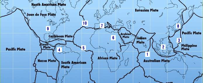
"Over to S America the Andes are shown doing mountain building, while some islands in the Caribbean are sinking, their plate
pushed under as S America rolls."
In this particular Blog will be describes and take note of all the Earth Changes of the World that will lead to the Geological Movement of the South American Plate: about 250 miles/400.33 Km to roll!.
https://poleshift.ning.com/forum/topics/zetatalk-chat-for-december-...
-Caribbean Subducting under Northern South America:
7 of 10 - Safe Locations
https://poleshift.ning.com/profiles/blogs/7-of-10-safe-locations
- Cover, front and back
- Table of Contents and Introduction
- Homeless
- Settlement
- High Tech Note: continued in the next PDF document
- Communities
- Resources
- Addendum
And finally, the Zetatalk predictions for safe locations are 100% accurate.
Tags:
Replies to This Discussion
-
Permalink Reply by Juan F Martinez on October 1, 2019 at 6:18am
-
Powerful Earthquakes in Chile 9-26-2019 to 9-29-2018
6,1 Los Lagos, Chile
6,2 Coquimbo, Chile
5,9 Islas de Pascua, Chile
7,2 Maule, Chile
-
Permalink Reply by Juan F Martinez on October 2, 2019 at 5:56pm
-
Caribbean Earthquakes 10-2-2019
Magnitude mb 4.5 + 2 = ~M6.5
Region PUERTO RICO REGION
Date time 2019-10-02 11:08:09.0 UTC
Location 19.02 N ; 67.28 W
Depth 10 km
Distances 138 km NW of San Juan, Puerto Rico / pop: 419,000 / local time: 07:08:09.0 2019-10-02
72 km N of Aguada, Puerto Rico / pop: 4,100 / local time: 07:08:09.0 2019-10-02
61 km N of San Antonio, Puerto Rico / pop: 2,300 / local time: 07:08:09.0 2019-10-02https://www.emsc-csem.org/Earthquake/earthquake.php?id=796448
-
Permalink Reply by Juan F Martinez on October 3, 2019 at 12:16am
-
Earthquakes of the Caribbean: 1918 - 2019
The M6.0 earthquake that occurred near Puerto Rico on September 24, 2019, was the largest earthquake to strike the U.S. territory in five years. It was not, however, the largest recorded earthquake there. That distinction goes to the July 7, 1943, M7.7 earthquake that thankfully did not generate a tsunami. Other earthquakes, and sometimes the landslides they cause, have produced tsunamis throughout the Caribbean Sea region, including one in Puerto Rico in 1918. Therefore this animation begins in 1918 and covers the 101 years up until the present day to show all of the recorded seismic activity in this region over that time period.*The Caribbean Sea lies over the Caribbean Plate, a section of the earth’s crust bounded by active faults separating it from other tectonic plates. These other plates include the North American Plate to the north and east and the Pacific Plate to the west. Relative motions between these plates cause earthquakes at their boundaries. Most of the east-west trending boundaries are “strike-slip” or transform faults such that the plates move past each other horizontally, similar to the famous San Andreas Fault in California. Since they move sideways they do not generally cause earthquakes that move the ocean water above them, though they can trigger landslides that generate tsunamis, such as in Haiti in 2010. But the boundaries of the Caribbean Plate that run northwest-southeast in Central America and the Leeward Islands are subduction zones, a type of plate boundary that can produce megathrust earthquakes with large vertical motions that can cause devastating tsunamis, such as the pair of devastating Dominican Republic earthquakes in 1946.
Some earthquakes in this region that produced significant tsunamis include:
Oct 11, 1919 -- M7.1 -- Puerto Rico (tsunami killed 140)
Aug 5, 1946 -- M7.5-- Dominican Republic (tsunami killed 1790)
Aug 8, 1946 -- M7.0 -- Dominican Republic (tsunami killed 75)
Apr 22, 1991 -- M 7.6 -- Costa Rica (tsunami killed 3)
Sep 2, 1992 -- M7.7 -- Nicragua (tsunami killed 170 on the Pacific coast)
Jan 12, 2010 -- M7.0 -- Haiti (tsunami killed 7)
Aug 27, 2012 -- M7.3 -- El Salvador (Pacific Coast, no deaths)Today the Pacific Tsunami Warning Center (PTWC) will issue tsunami alerts for any potentially tsunami-causing earthquake in the Caribbean region. These will be posted to:
For more information about mitigating tsunami hazards in this region please see the Caribbean Tsunami Warning Program (CTWP):
Earthquake Data Source: United States Geological Survey (USGS)/National Earthquake Information Center (NEIC) searchable catalog:
-
Permalink Reply by Juan F Martinez on October 25, 2019 at 3:43am
-
Magnitude mb 4.4 + 2 = ~M6.4Region PUERTO RICO REGIONDate time 2019-10-25 00:30:28.0 UTCLocation 17.89 N ; 66.33 WDepth 9 kmDistances 68 km S of San Juan, Puerto Rico / pop: 419,000 / local time: 20:30:28.0 2019-10-2410 km SE of Jauca, Puerto Rico / pop: 1,900 / local time: 20:30:28.0 2019-10-24Testimony: "This was not a 4.4.We are at 3000’ elevation in the Western interior of PR and felt it swaying!!"
-
Permalink Reply by Juan F Martinez on November 1, 2019 at 10:35pm
-
A strange phenomenon appeared in the sky of Tunapuna, a town in the East–West Corridor of the island of Trinidad, in Trinidad and Tobago. Could this be a large gas release as South America rolls over the Caribbean plate? Hmm.
"It was filmed Thursday 31st October, 2019 at approximately 1pm in Tunapuna." Rodney Mc Lean
-
Permalink Reply by Juan F Martinez on November 14, 2019 at 2:37pm
-
DOMINICAN REPUBLIC 11-12-2019
For the second time in two months, the Fula river in BONAO surged.
Second documented event from September 19, 2019: https://youtu.be/u9hBpxWNUzU
I think the ground is HEAVING and adjusting. Caribbean plate is sinking near Venezuela, tilting, bending and shifting along the north side of DR and PR.

-
Permalink Reply by Khan on December 23, 2019 at 2:01am
-
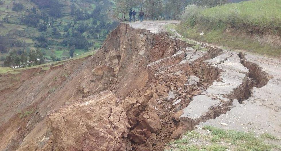
Peru: Seven road corridors blocked in Áncash.
Dec 21, 2019

The roads of the provinces of Mariscal Luzuriaga, Sihuas, Carlos Fermín Fitzcarrald, Pomabamba and Antonio Raimondi in the Ancash region are blocked by the fall of huaicos in different points of the roads, according to information from the Regional Emergency Operations Center (COER ) in Huaraz.
-
Permalink Reply by Recall 15 on December 23, 2019 at 3:04am
-
Colombia: Partial Collapse of a Bridge at Ciénaga Magdalena:
In a bridge under construction 7 concrete beams of 45 tons and 50mts/164ft just snaps and fall to the ground
Captured image:
"The huge concrete plates broke in half". Then “The earth vibrated hard”: witnesses of the partial collapse of the bridge in Ciénaga
From:
https://translate.google.com/translate?hl=es&sl=es&tl=en&am...
-
Permalink Reply by Recall 15 on January 2, 2020 at 10:35pm
-
01/01/2020 Landslide captured by tourists at "Cañón del Sumidero" Chiapas MX.
A wall of the Sumidero Canyon suffered a landslide on Wednesday afternoon.
The phenomenon was captured by tourists sailing on the Grijalva River, so they suspended the route...... The collapse forced the preventive closure of tourist navigation on the tributary, authorities said.
Experts from the State Secretariat of Civil Protection and the National Commission of Natural Protected Areas (Conanp) will go to the area this Thursday to make the first evaluations and determine the causes of the event.From:
https://translate.google.com/translate?hl=es&sl=es&tl=en&am...
-
Permalink Reply by Juan F Martinez on January 8, 2020 at 4:31pm
-
Magnitude Mw 4.8 Region DOMINICA REGION, LEEWARD ISLANDS Date time 2020-01-08 14:01:52.2 UTC Location 15.20 N ; 61.36 W Depth 144 km Distances 12 km S of Roseau, Dominica / pop: 16,600 / local time: 10:01:52.2 2020-01-08
6 km SE of Pointe Michel, Dominica / pop: 1,300 / local time: 10:01:52.2 2020-01-08
4 km S of Soufrière, Dominica / pop: 1,100 / local time: 10:01:52.2 2020-01-08
-
Permalink Reply by Recall 15 on January 28, 2020 at 9:50pm
-
A Mag 7.7 Quake @ South of Cuba:
Havana 28 Jan 2020 - 21:13 CET
"
Although there are no precise reports on tsunami warnings so far, geologist Christa Von Hillebrant-Andrade of the National Oceanic and Atmospheric Administration (NOAA) in the United States told the Puerto Rican newspaper El Nuevo Día that "there is potential for Tsunami threat to all points that are 300 kilometers from the epicenter. "
"We are reviewing the impact potential in Cuba," he said.
According to the USGS, so far there are reports of perceptibility of the earthquake in the Cayman Islands, The Bahamas, Cuba, Honduras and Jamaica.
On the other hand, Cuban users of social networks claimed to have felt the telluric movement in Guantanamo, Santiago de Cuba, Granma, Holguin, Las Tunas, Camaguey, Cienfuegos, Havana, Pinar del Río and Isla de la Juventud.
"
From:
https://translate.google.com/translate?sl=auto&tl=en&u=http...
Also
On twitter, Cubans begin to report several places where the earthquake was noticeable. In addition to the provinces mentioned by the aforementioned media, there are reports of perceptibility in Ciego de Ávila, Cienfuegos and Camagüey.
A replica of 6.9 degrees has been registered in Santiago de Cuba.
https://translate.google.com/translate?sl=auto&tl=en&u=http...
SEARCH PS Ning or Zetatalk
This free script provided by
JavaScript Kit
Donate
© 2025 Created by 0nin2migqvl32.
Powered by
![]()
