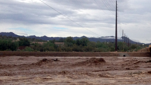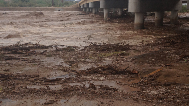
"We warned at the start of ZetaTalk, in 1995, thatunpredictable weather extremes, switching about from drought to deluge,would occur and increase on a lineal basis up until the pole shift. Where this occurred steadily, it has only recently become undeniable. ZetaTalk, and only ZetaTalk, warned of these weather changes, at that early date. Our early warnings spoke to the issue of global heating from the core outward, hardly Global Warming, a surface or atmospheric issue, but caused by consternation in the core. Affected by the approach of Planet X, which was by then starting to zoom rapidly toward the inner solar system for its periodic passage, the core was churning, melting the permafrost and glaciers and riling up volcanoes. When the passage did not occur as expected in 2003 because Planet X had stalled in the inner solar system, we explained the increasing weather irregularities in the context of the global wobble that had ensued - weather wobbles where the Earth is suddenly forced under air masses, churning them. This evolved by 2005 into a looping jet stream, loops breaking away and turning like a tornado to affect the air masses underneath. Meanwhile, on Planet Earth, droughts had become more intractable and deluges positively frightening, temperature swings bringing snow in summer in the tropics and searing heat in Artic regions, with the violence of storms increasing in number and ferocity."
The wobble seems to have changed, as the temperature in Europe suddenly plunged after being like an early Spring, Alaska has its coldest temps ever while the US and much of Canada is having an extremely mild winter. India went from fatal cold spell to balmy again. Has the Earth changed position vs a vs Planet X to cause this?[and from another]Bitter cold records broken in Alaska - all time coldest record nearly broken, but Murphy's Law intervenes[Jan 30]http://wattsupwiththat.com/2012/01/30/bitter-cold-records-broken-in-alaskaJim River, AK closed in on the all time record coldest temperature of -80°F set in 1971, which is not only the Alaska all-time record, but the record for the entire United States. Unfortunately, it seems the battery died in the weather station just at the critical moment. While the continental USA has a mild winter and has set a number of high temperature records in the last week and pundits ponder whether they will be blaming the dreaded "global warming" for those temperatures, Alaska and Canada have been suffering through some of the coldest temperatures on record during the last week.
There has been no change in the wobble pattern, the wobble has merely become more severe. Nancy noted a Figure 8 format when the Earth wobble first became noticeable, in early 2005, after Planet X moved into the inner solar system at the end of 2003. The Figure 8 shifted along to the east a bit on the globe between 2005 and 2009, (the last time Nancy took its measure) as Planet X came closer to the Earth, encountering the magnetic N Pole with a violent push earlier in the day. But the pattern of the Figure 8 remained essentially the same. So what changed recently that the weather patterns became noticeably different in late January, 2012?
The N Pole is pushed away when it comes over the horizon, when the noon Sun is centered over the Pacific. This regularly puts Alaska under colder air, with less sunlight, and thus the historically low temps there this January, 2012 as the wobble has gotten stronger. But by the time the Sun is positioned over India, the N Pole has swung during the Figure 8 so the globe tilts, and this tilt is visible in the weather maps from Asia. The tilt has forced the globe under the hot air closer to the Equator, warming the land along a discernable tilt demarcation line.
The next loop of the Figure 8 swings the globe so that the N Pole moves in the other direction, putting the globe again at a tilt but this time in the other direction. This tilt is discernable in weather maps of Europe, again along a diagonal line. Depending upon air pressure and temperature differences, the weather on either side of this diagonal line may be suddenly warm or suddenly cold. The tilt and diagonal line lingers to affect much of the US and Canada, but the Figure 8 changes at this point to be an up and down motion, pulling the geographic N Pole south so the US is experiencing a warmer than expected winter under a stronger Sun. Then the cycle repeats, with the magnetic N Pole of Earth pushed violently away again as the Sun is positioned over the Pacific.
Would the Zetas be able to let us know what is causing the early break-up of the Arctic Ice, the ice seems to have taken on a swirling pattern at the same time, would this be wobble related?[and from another]http://www.vancouversun.com/news/national/Canada+Arctic+cracks+spec... The ice in Canada’s western Arctic ripped open in a massive “fracturing event” this spring that spread like a wave across 1,000 kilometres of the Beaufort Sea. Huge leads of water – some more than 500 kilometres long and as much as 70 kilometres across – opened up from Alaska to Canada’s Arctic islands as the massive ice sheet cracked as it was pushed around by strong winds and currents. It took just seven days for the fractures to progress across the entire area from west to east.[and from another]http://earthobservatory.nasa.gov/IOTD/view.php?id=80752&src=iot... A high-pressure weather system was parked over the region, producing warmer temperatures and winds that flowed in a southwesterly direction. That fueled the Beaufort Gyre, a wind-driven ocean current that flows clockwise. The gyre was the key force pulling pieces of ice west past Point Barrow, the northern nub of Alaska that protrudes into the Beaufort Sea.
The Figure 8 formed by the N Pole during the daily Earth wobble has shifted somewhat to the East, due to Planet X positioned more to the right of the Earth during its approach. This was anticipated, and well described in ZetaTalk, the Earth crowding to the left in the cup to escape the approach of Planet X, so the angle between these two planets would change slightly. This shift of the Figure 8 to the East is due to the push against the Earth’s magnetic N Pole occurring sooner each day than prior. Thus instead of occurring when the Sun is high over the Pacific, over New Zealand, it is now occurring when the Sun is high over Alaska. All the wobble points have shifted eastward accordingly.
This has brought a lingering Winter to the western US, and a changed sloshing pattern to the Arctic waters. Instead of Pacific waters being pushed through the Bering Straits into the Arctic when the polar push occurs, the wobble is swinging the Arctic to the right, and then later to the left, creating a circular motion in the waters trapped in the Arctic. Since the Earth rotates counterclockwise, the motion also takes this path. This is yet another piece of evidence that the establishment is hard pressed to explain. They are attempting to ascribe this to high pressure and wind, all of which are not new to the Arctic, but this circular early breakup of ice in the Arctic is new.
Comment by lonne rey on February 1, 2014 at 11:30pm
January was England's wettest winter month in almost 250 years
Last month's seasonal total was higher than any since 1767 and three times the average level
The deluge that has engulfed southern and central England in recent weeks is the worst winter downpour in almost 250 years, according to figures from the world's longest-running weather station.
The rainfall measured at the historic Radcliffe Meteorological Station at Oxford University in January was greater than for any winter month since daily recording began there in 1767, and three times the average amount.
The latest Met Office data shows that the region from Devon to Kent and up into the Midlands suffered its wettest January since its records began in 1910.
This link is updated 1-2x a day, so after 27 Jan it may be different.
This is exactly what we have been experiencing in South Dakota for the past month. This is actually a mild swing back and forth compared to two weeks ago when we went from -5F to 51F then 48F then back to 12F the next day. It is hard for the body to adjust to this! Too cold, too warm... it has been like this since December 2013!
In addition, it has been continually WINDY for almost 3 weeks. We have had high wind warnings in place EVERY DAY somewhere in the upper Midwest since the first week of January 2014.
This is the weather for Custer, SD for the month of January 2014: (notice the range for the normal high and low below)
I've never been a fan of roller coasters... and this is only the beginning.
Comment by SongStar101 on January 27, 2014 at 10:16am
Extreme Chill in the Eastern US continues, unusually mild in the West. Wobble pattern anomalies are very noticeable. GFS shows the Polar Wobble pattern going completely whack. Worst cold ever for some regions.
GFS Ensemble 500mb anomaly (left) and spaghetti (right) forecast for 6 days out.
CHICAGO (AP) — A persistent weather pattern driving bitterly cold air south out of the Arctic will cause temperatures from Minnesota to Kentucky to plummet Monday, turning this winter into one of the coldest on record in some areas.
For about 2½ days, actual temperatures will range from the teens to below zero, and the wind chills will be even colder, minus 43 in Minneapolis, minus 23 in Milwaukee and Chicago, minus 14 in Kansas City, Mo., and minus 3 in Louisville.
In fact, the National Weather Service says most of the Midwest will feel far colder than Monday's expected high in the nation's northernmost city, Barrow, Alaska — minus 4.
National Weather Service Meteorologist Scott Blair stopped short of calling the latest round of cold part of the polar vortex, which are winds that circulate around the North Pole.
"There's really nothing abnormal about the air that's coming into the area," he said. "It's just been a very persistent pattern" of cold air.
He said it's an amplified pattern of the jet stream, and cold air is filtering in behind a large trough of low pressure. He explained further: "Troughs are typically associated with unstable or unsettled weather, and, at this time of the year, much colder air."
In the Chicago area, residents were bracing for a historic deep freeze. Monday's high was expected to be minus 4 degrees, and it could get as low as negative 17 downtown, with wind chills as low as 40 below. Such temperatures are expected to hold into Tuesday.
If Chicago makes it to 60 hours below zero, it will be the longest stretch since 1983, when it was below zero for 98 hours, and the third longest in 80 years.
Chicago Public Schools called off Monday's classes for its nearly 400,000 students a day in advance, as did suburban districts. Earlier this month, when it was below zero for 36 straight hours, CPS closed for two days.
North Dakota and South Dakota residents dealt with dangerous cold Sunday and wind gusts that reached up to 60 mph. The high winds led to blowing snow that made it nearly impossible to travel in some parts.
"This is definitely the most widespread event we've had this year," said weather service meteorologist Adam Jones in Grand Forks, N.D.
Snow and high winds in Indiana led officials there to restrict vehicle traffic or recommend only essential travel in more than half of the state's counties. And Iowa officials said the combination of snow and high winds would make traveling dangerous; forecasters there called for wind chills to be as low as 40 below zero on Monday.
In Michigan, snow on the roads and deep subfreezing temperatures contributed to multiple crashes Sunday that forced expressway closings. And on Saturday night, two people were killed in Grand Haven Township in western Michigan because of similar weather conditions, authorities said.
Alex Alfidi, manager at Leo's Coney Island restaurant in the Detroit suburb of Birmingham, said the extreme winter weather is hurting his business.
"We slowed down big time," Alfidi, 39, said, noting that while he's been getting some carryout business, the casual walk-in customers have been staying away.
He also said it's hard for him and his employees to get to and from work in the snow, ice and cold. Sometimes, the 24-hour restaurant is operating with just him and a waitress.
Alfidi said he has seen some challenging winters in 15 years in Michigan, but none as bad as the current winter.
2013 was a dry year for California, but it has nothing on 2014 so far. January is on track to be California’sdriest on record, and since the state receives half of its precipitation between December and February, it appears that the2013-2014 water yearcould be the driest on record too. With that possibility in view, California governor, Edmund Brown declared a state of emergency on January 17, urging Californians to conserve water.
From brown landscapes to the bare mountains, California is clearly dry in this view from the Moderate Resolution Imaging Spectroradiometer (MODIS) on NASA’s Terra satellite, taken on January 18, 2014. The lower image, taken on January 18, 2013, contrasts last year’s drought conditions with the extreme conditions currently in place.
The most striking difference between the two years is the amount of snow cover on mountains. The Sierra Nevada range has very little snow, and Coast Range and Cascade Mountains are almost completely snow free. California gets a third of its water supply from mountain snow, but with warm, dry weather, little snow has accumulated. In January 2014, thesnowpackwas between 10 and 30 percent of normal. Since much of the snow pack can come from just a few events, one or two big storms could make a significant difference. The widespread snow in 2013 may be from one such event, since snow covers not only the mountains, but also the basins and ranges of Nevada to the east. By spring of 2013, the Sierra Nevada snowpack would be well below average, contributing to the worsening drought.
Less striking at first glance, but just as telling is the condition of the vegetation west of the Sierra Nevada. In 2013—a year into the drought—the central valley was green with growing crops. The coastal hills were also green from winter rain. In 2014, everything west of the forested mountains is brown. Even irrigated agriculture in the center of the state appears to be limited compared to 2013. Viewing the images with the image comparison tool makes it easier to see the difference in vegetation from last year to this year.
Under such conditions, California may be prone to water shortages, crop loss and the loss of farm jobs, and increased wildfires, warned the emergency proclamation.
Comment by SongStar101 on January 16, 2014 at 1:26pm
Major California Drought Could Spell 'Catastrophe' for Nation's Food Supply
'Possibly hundreds of thousands of acres of land will go fallow' in California
A major and unyielding drought in California is causing concern in the nation's "food basket," as farmers there say the U.S. food supply could be hit hard if the conditions in their state don't rapidly improve, Al Jazeera Americareports Tuesday.
"This is the driest year in 100 years,” grower Joe Del Bosque told Al Jazeera, expressing concern that the hundreds of workers he employs for each year's harvest could be without a job this season.
According to the U.S. Drought Monitor, 2013 was the driest on record for most areas of California, "smashing previous record dry years" across the state, including regions where approximately half the fruits, vegetables and nuts in the U.S. are grown.
Those conditions have not relented as 2014 begins with most of the state experiencing official 'severe' or 'extreme drought' conditions.
And as Al Jazeera reports, reservoirs, which store water that flows from the snow pack in the Sierra Nevada mountains, are at less than 50 percent capacity—20 percent below average for this time of year.
Comment by jorge namour on January 15, 2014 at 11:17am
Norway: The sea froze so fast that killed thousands of fish instantly
Posted: 14 Jan 2014
Air temperature (7.8 degrees Celsius) in Lovund Island (Norway) in combination with a strong wind immediately frozen sea water, trapping and killing thousands of fish.
Some locals say they've never seen a phenomenon of such magnitude. However, Aril Slotte, Head of Fish, Institute of Marine Research in Norway, said in statements to the local radio 'NRK' which is not uncommon, for example, sardines are much closer to the shore when they are followed by predators and sometimes become trapped by low tide in areas like where this oddity occurred.
Comment by sourabh kale on January 13, 2014 at 2:36am
EARTH WOBBLE ANYONE
Polar vortex over US brings abnormally mild weather to Scandinavia
Weather system disrupts flora and fauna in Nordic countries, with bears reportedly emerging from hibernation
Friday 10 January 2014
The freezing polar vortex that has gripped the US has extended an abnormally mild winter in Scandinavia and disrupted the seasonal patterns of flora and fauna.
Scandinavia and Russia's cold weather during the winter comes from a high-pressure system that keeps warmer, more humid air and low-pressure systems with wind and rain from coming up from the Atlantic Ocean.
The weakening of the jetstream that holds this in place has allowed cold air to spill further south into much of the United States and Canada, while bringing above-average temperatures to parts of Europe.
The knock-on effects of the vortex follow one of the mildest Decembers in a century in Nordic countries. Ketil Isaksen, a scientist at the Norwegian Meteorological Institute, said the country had been 4.2C above the mean temperature for December with parts of Oslo and south-eastern Norway experiencing the third warmest December on record. "It was very unusual to see no snow in large areas where it is normal in December. Only in the mountains and certain parts of Norway could you find snow."
Much of the precipitation in lowland and populated areas had fallen as rain instead of snow, he said. "In general it was a very wet December. Large parts of Norway had up to three times as much rain as normal and the country as a whole had 180% more than average."
Finland too has seen heavy rain, with flooding in western coastal areas and the majority of Finland's lakes containing record volumes of water. Temperatures exceeded their normal seasonal average by 4-5C nationwide, with Helsinki and southern Finland recording the mildest second half of December in 30 years.
Temperatures in parts of Sweden have fluctuated greatly, at Nikkaluokta falling from 4.7C on 3 December to -40.8C on 9 December, then rising two days later to 7.7C. Many locations measured their warmest December temperatures on record. "In the north, winter has arrived, but in the south it's autumn according to the meteorological definition," the Swedish Meteorological and Hydrological Institute said.
The rainy weather in Finland has reportedly disrupted the winter slumbers of many bears, bringing them out of hibernation early. Heavy rains and high waters may have invaded some dens, forcing the animals to seek new shelter.
Prof Jon Swenson of the Norwegian University of Life Sciences, leader of the Scandinavian bear project, said he was worried about the indirect effects of the warmer weather. "If you go down into southern Europe, it's warmer, and there are some bears that don't hibernate.
"It doesn't seem to be harmful not to hibernate," he said. "What we are afraid of is that it means there will be more thawing periods … this really stresses the berry-producing plants. This can cause some mortality, and can have a very adverse effect on berry production. And that's what the bears survive on in the autumn, and what they use to get them through the winter. So the results of this mild weather won't be seen for some time."
Last week, the local Norwegian newspaper Sunnmørsposten published reader photographs of daffodils emerging as early as 14 December as well as crocuses, daisies, dandelions and honeysuckle.
The World Wide Fund for Nature (WWF) Norway chief executive, Nina Jensen, said she was "cautious about drawing conclusions from one mild winter into specific changes in nature", but there were signals that changes were happening.
"We are definitely seeing plants like bluebells flowering that wouldn't come out until spring, and birds singing that wouldn't normally be at this time of year. There are quite obvious changes in the growth season, plant growth and migratory bird routes and timing. The flip side of this warmer winter is that we will also have an increasing threat of harmful introduced organisms, such as the wild boar or ticks that thrive in warmer temperatures."
Pål Hermansen, a wildlife photographer based in Oslo, said: "It's the smaller things where you see it most, especially butterflies and other insects. The combination of 'proper winters' with lots of snow, alternating with winters like this one, makes everything very unstable. In the 30 years I've been working we've seen butterfly populations reduce by 80-90%. We're now seeing mosquitos and ticks during the winter, which is unheard of. Ticks are spreading much further north than they ever were before."
Stephen Menzie, an ornithologist working at Falsterbo Bird Observatory – a migration point in south-west Sweden – said it was "certainly true" that milder weather this year had played a part in delaying the southbound migration of many species.
"We had one day in November when we ringed over 800 birds, compared to the same period last year when we struggled to catch double figures on most days."
Comment by sourabh kale on January 12, 2014 at 4:56pm
FREEZING NORTH,BURNING SOUTH
Australia adds new colour to temperature maps as heat soars
"Forecast temperatures are so extreme that the Bureau of Meteorology has had to add a new colour to its scale. It is a sign of things to come
Tuesday 8 January 2013
Global warming is turning the volume of extreme weather up, Spinal-Tap-style, to 11. The temperature forecast for next Monday by Australia's Bureau of Meteorology is so unprecedented - over 52C - that it has had to add a new colour to the top of its scale, a suitably incandescent purple.
Australia's highest recorded temperature is 50.7C, set in January 1960 in South Australia. The record for the hottest average day across the nation was set on Monday, at 40.3C, exceeding a 40-year-old record. "What makes this event quite exceptional is how widespread and intense it's been," said Aaron Coutts-Smith, the weather bureau's climate services manager. "We have been breaking records across all states and territories in Australia over the course of the event so far." Wildfires are raging across New South Wales and Tasmania.
Australia's prime minister Julia Gillard said: "Whilst you would not put any one event down to climate change, weather doesn't work like that, we do know over time that as a result of climate change we are going to see more extreme weather events and conditions."
A fire danger rating sign set to catastrophic sends out a clear message on the situation on the outskirts of Wandandian south of Nowra, near Sydney, New South Wales. Four new ares in NSW have been given a 'catastrophic 'fire danger rating meaning that if fires break out they will be uncontrollable and fast moving, so residents should leave Photograph: Dean Lewins/EPA"
You need to be a member of Earth Changes and the Pole Shift to add comments!
Join Earth Changes and the Pole Shift