Please Place Evidence of the 7 of 10 Plate Movements Here
Kojima had created small snips of Konstantin's animation of the 7 of 10 Plate Movements.
Here is the full 7 of 10 Animation by Konstantin.
This blog is the place to document ongoing earth changes related to the 7 of 10 plate movements as described by the Zetas.
ZetaTalk: 7 of 10 Sequence
written October 16, 2010
The 7 of 10 scenarios describe plate movements, and for this to occur something has to release the deadlock, the current stalemate where the plates are locked against each other. Once the deadlock is broken and the plates start moving, sliding past each other, new points where the plates are locked against each other develop, but these are weaker locks than the one at present. The current lock, as we have so often stated, is the Indo-Australian Plate which is being driven under the Himalayans. This is no small lock, as the height of the Himalayans attests. Nevertheless, the activity in this region shows this likely to be the first of the 7 of 10 scenarios to manifest. Bangladesh is sinking and the Coral Sea is rising, showing the overall tipping of the Indo-Australian Plate. Now Pakistan is sinking and not draining its floods as it should, while Jakarta on the tongue of Indonesia is also sinking rapidly, showing that the tilt that will allow Indonesia to sink has already started.
Meanwhile, S America is showing signs of a roll to the west. Explosions on islands just to the north of the S American Plate occurred recently, on Bonaire and Trinidad-Tobago, and the Andes are regularly being pummeled. There is a relationship. As the Indo-Australia Plate lifts and slides, this allows the Pacific plates to shift west, which allows S America to shift west also. This is greatly increased by the folding of the Mariana Trench and the Philippine Plate. But it is the Indo-Australian Plate that gives way to incite change in these other plates, and this is what is manifesting now to those closely following the changes. Once the folding of the Pacific has occurred, Japan has been destabilized. We are not allowed to give a time frame for any of these plate movements, but would point out that it is not until the North Island of Japan experiences its strong quakes that a tsunami causing sloshing near Victoria occurs. There are clues that the New Madrid will be next.
Where the N American continent is under great stress, it has not slipped because it is held in place on both sides. The Pacific side holds due to subduction friction along the San Andreas, and the Atlantic side holds due to the Atlantic Rift's reluctance to rip open. What changes this dynamic? When S America rolls, almost in step with the folding Pacific, it tears the Atlantic Rift on the southern side. This allows Africa freedom to move and it rolls too, dropping the Mediterranean floor above Algeria. What is holding the N American continent together has thus eased, so that when the Japan adjustments are made, there is less holding the N American continent in place than before, and the New Madrid gives way. We are also not allowed to provide the time frame between the Japan quakes and New Madrid. Other than the relationship in time between the New Madrid and the European tsunami, no time frame can be given. The sequence of events is, thus:
- a tipping Indo-Australia Plate with Indonesia sinking,
- a folding Pacific allowing S America to roll,
- a tearing of the south Atlantic Rift allowing Africa to roll and the floor of the Mediterranean to drop,
- great quakes in Japan followed by the New Madrid adjustment,
- which is followed almost instantly by the tearing of the north Atlantic Rift with consequent European tsunami.
Source: http://www.zetatalk.com/index/zeta584.htm
Tipping Indo-Australia Plate with Indonesia sinking,
http://zetatalk.com/7of10/7of10-23.htm
http://zetatalk.com/7of10/7of10-24.htm
http://zetatalk.com/7of10/7of10-25.htm
http://zetatalk.com/7of10/7of10-26.htm
http://zetatalk.com/7of10/7of10-28.htm
http://zetatalk.com/7of10/7of10-30.htm
http://zetatalk.com/7of10/7of10-31.htm
http://zetatalk.com/7of10/7of10-32.htm
http://zetatalk.com/7of10/7of10-34.htm
http://zetatalk.com/7of10/7of10-37.htm
Folding Pacific
http://zetatalk.com/7of10/7of10-33.htm
http://zetatalk.com/7of10/7of10-38.htm
http://www.zetatalk.com/info/tinfx351.htm
http://zetatalk.com/7of10/7of10-47.htm
South American Roll
http://zetatalk.com/7of10/7of10-39.htm
http://zetatalk.com/7of10/7of10-40.htm
http://zetatalk.com/7of10/7of10-41.htm
http://zetatalk.com/7of10/7of10-42.htm
http://zetatalk.com/7of10/7of10-43.htm
http://zetatalk.com/7of10/7of10-44.htm
http://zetatalk.com/7of10/7of10-45.htm
http://zetatalk.com/7of10/7of10-47.htm
African Roll
http://www.zetatalk.com/7of10/7of10-46.htm
http://zetatalk.com/7of10/7of10-47.htm
http://zetatalk.com/7of10/7of10-48.htm
http://zetatalk.com/7of10/7of10-52.htm
Japan Quakes
http://www.zetatalk.com/7of10/7of10-53.htm
http://zetatalk.com/7of10/7of10-54.htm
New Madrid
http://www.zetatalk.com/7of10/7of10-59.htm
http://www.zetatalk.com/7of10/7of10-60.htm
http://zetatalk.com/7of10/7of10-61.htm
http://www.zetatalk.com/7of10/7of10-62.htm
http://zetatalk.com/7of10/7of10-63.htm
http://zetatalk.com/7of10/7of10-64.htm
http://zetatalk.com/7of10/7of10-65.htm
http://zetatalk.com/7of10/7of10-68.htm
European Tsunami
http://zetatalk.com/7of10/7of10-70.htm
http://zetatalk.com/7of10/7of10-71.htm
http://zetatalk.com/7of10/7of10-72.htm
http://zetatalk.com/7of10/7of10-73.htm
http://zetatalk.com/7of10/7of10-74.htm
Due to the slowing of the 7 of 10 plate movements by the Council of Worlds the impact of some of the events described above will be lessened.
The Zetas explain:
ZetaTalk: Pace Slowed
Written May 19, 2012
The effect of the thousands of humming boxes placed along fault lines and plate borders can be seen in several incidents that have occurred since the start of the 7 of 10 plate movements. The lack of tsunami during the 7 of 10 sinking of the Sunda Plate is one such example. We predicted at the start of the 7 of 10 scenarios in late 2010 that the Sunda Plate sinking would occur within 2-3 weeks, yet it dragged on through 2011. At the time we had predicted tsunami on the Sunda Plate, in general equivalent in height to the loss of elevation for a coastline. None of this occurred due to the slower pace.
The pace of mountain building in S America, where slowed, has still resulted in rumpling up and down the Andes, and stretch zone accidents likewise in lands to the east of the Andes. The shape of S America has clearly changed. Will the islands in the Caribbean be spared? At some point, as with the magnitude 7.9 quake in Acapulco on March 2, 2012 a significant adjustment will need to occur, and this will include depressing the Caribbean Plate so it tilts, sinking the islands and lands on that portion of the plate to the degree predicted. But the S American roll will likely continue to avoid the magnitude 8 quakes we originally predicted in deference to slow rumpling mountain building. The African roll was anticipated to be a silent roll in any case, so the slowed pace would not affect the outcome.
Will the slowed pace prevent the 7 of 10 scenarios for the Northern Hemisphere? Bowing of the N American continent has reached the point of pain, with breaking rock booming from coast to coast, but still there have been no significant quakes in the New Madrid area. Yet this is past due, and cannot be held back indefinitely. What has and will continue to occur for the Northern Hemisphere scenarios are silent quakes for Japan, which has already experienced drastic subduction under the north island of Hokkaido where mountain building is occurring as a rumple rather than a jolt. However, the anticipated New Madrid adjustment cannot be achieved without trauma. But this could potentially occur in steps and stages such that any European tsunami would be significantly lessened.
All rights reserved: ZetaTalk@ZetaTalk.com
Source: http://www.zetatalk.com/7of10/7of10109.htm
ZetaTalk , Written March 10, 2012
What happens when the pace of plate movement is slowed? The likelihood of tsunami is definitely reduced, as can be seen in the sinking on the Sunda Plate. The sinking occurred, and is almost complete, yet the possibility of tsunami we predicted for various regions on the Sunda Plate were avoided. The height and force of a tsunami is directly related to the degree of displacement in the sea floor, and if this happens in steps rather than all at once the displacement will be less for any given step.
This bodes well for the European tsunami. If the Council of Worlds is still imposing a slower pace on the 7 of 10 plate movements, this tsunami will definitely be lessened. The tear in the North Atlantic will be slight, each time. The amount of water pouring into this void will be less, each time. And the rebound toward the UK will likewise be less, each time. But our prediction is the worst case situation, and it also reflects what the Earth changes, unabated, would produce.
But what does a slower pace do to land masses where jolting quakes are expected? Does this reduce the overall magnitude of the quakes anticipated? Large magnitude quakes result when a catch point along plate borders is highly resistant, but snapping of rock finally results. Usually there is one place, the epicenter, where this catch point resides and a long distance along the plate border where smaller quakes have prepared the border for easy movement. A point of resistance within the body of a plate, such as the New Madrid, can likewise resist and suddenly give.
There is no way to lessen the resistance at these catch points, though the tension that accompanies such points can be reduced so that the quake itself is delayed. What this means for a slower 7 of 10 pace is that large magnitude quakes will be spread apart in time, and their relationship to our predictions thus able to be camouflaged by the establishment. Where sinking (such as the Caribbean Island of Trinidad) or spreading apart (such as to the west of the Mississippi River) are to occur, these land changes will eventually arrive. But like the sinking of the Sunda Plate, a slower pace unfortunately allows the cover-up time to maneuver and develop excuses.
All rights reserved: ZetaTalk@ZetaTalk.com
Views: 119555
Comment
-
Comment by Stanislav on October 27, 2015 at 2:37pm
-
Philippines
Click to view full resolution - Landsat 8 (Source: earthexplorer)
24 October, 2015
[22 October, 2015]
[23 October, 2015]
[18 August, 2015] (Source: MODIS Subsets; worldview.earthdata)
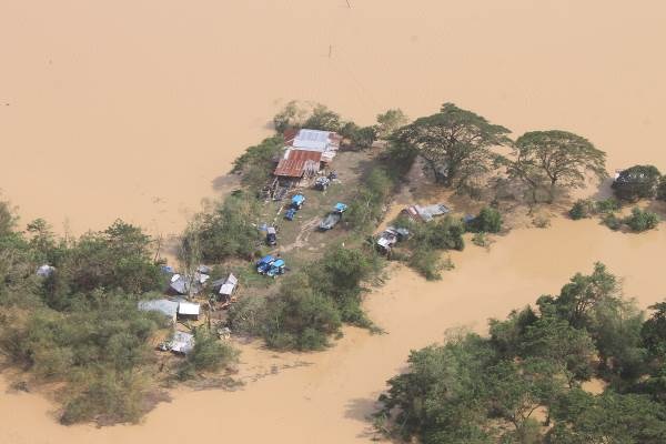
25 October, 2015. Ground swallows 4 houses in Itogon
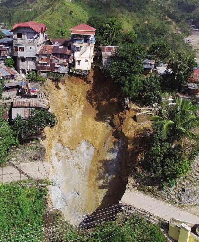
Four houses crumpled and fell into a gaping hole that gave way beneath a community in Benguet’s mining town of Itogon on Thursday, a day after Typhoon “Lando” (international name: Koppu) left the country.
Results of initial geological investigation, however, discounted speculation that the hole was part of an old tunnel once used for a mining operation there.
Fay Apil, a geologist and Cordillera director of the Mines and Geosciences Bureau (MGB), said the houses were dragged down the side of a hill and swallowed by the hole in Virac village.
Itogon Mayor Victorio Palangdan said the families living in the collapsed houses managed to flee after they felt their houses were shaking.
He said the hole gave way gradually. The first evidence of subsidence was detected by residents at 10 a.m. on Thursday. The hole began to grow wider in the afternoon.
The displaced families, as well as 32 other people, were relocated to Virac Elementary School.
Apil said at least 100 families were evacuated from the area. “The police worked quickly to clear these houses,” she said, after she and a team inspected the ground subsidence and helped identify the endangered houses.
Palangdan said engineers of the mining company came to check on the ground movement on Saturday. “But they did not show us any plans of action yet,” he said.
Apil said geologists and the mining company’s engineers inspected two underground mine structures which run beneath the subsidence area in Virac.
She said the old “Vegas” tunnel was the closest, having been part of the company’s tourist-drawing mine tours. But the team found no evidence of collapse there when it visited the tunnel.
Apil said the team also inspected the old “Diversion Tunnel No. 1,” which is being used to discharge water. On the surface, the length of this diversion channel is equivalent to an 80-meter stretch from the road.
But the team, accompanied by Virac village chief Noel Bilibli, checked the tunnel outlet and concluded that the volume of discharge was unhampered and the quality of water was clear, she said.
The diversion tunnel had not been compromised, she said, adding that the team and local officials would enter the tunnel on Oct. 27.
She said the MGB is working on another theory: The void underneath might be the result of operations of illegal small-scale miners. She did not elaborate.
Itogon is home to some of the country’s first mining companies, most of which were established when the country was ruled by the American colonial government. Vincent Cabreza and Kimberlie Quitasol, Inquirer Northern Luzon. Source: newsinfo.inquirer.net
-
-
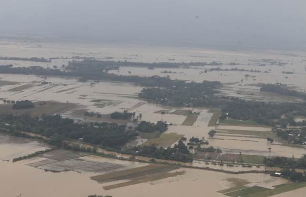
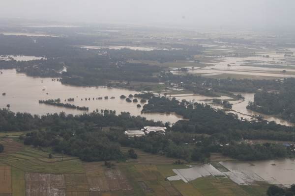
Philippines floods:
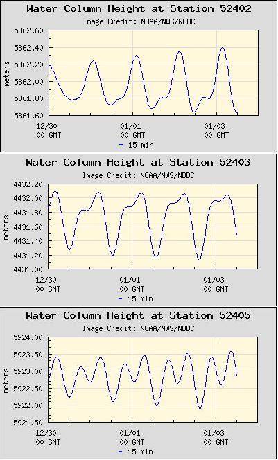
The Philippines is sinking! Certainly the buoys to the east of the Philippines indicate action, as the sea flood is dropping there, water on the rise! The buoys above New Guinea, in the Pacific, likewise indicate a rising sea level. What could this mean?
There is indeed a relationship between the high waves and flooding in the Philippines in those towns along the eastern coastline and inland with access to the sea. The Philippines have begun to sink, though such sinking is never such that an entire land mass or large island sinks uniformly, so can be deceptive. There is an additional influence from the tilting of the Philippine Plate and continued compression out in the Pacific, so that water is heaped to the east of the Philippine Islands, and is washing over their eastern shores during equalization of the water level. However, this latter is a relatively small influence. The issue with flooding is absolutely due to a dropping in elevation for some parts of the Philippines.
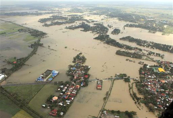
In this photo provided by the Philippine Air Force, floodwaters inundate homes and rice fields in northern Philippines Tuesday Oct. 20, 2015. Tropical Storm Lando (international name Koppu) finally blew away from the main northern Philippine island Tuesday, after leaving several dead over the weekend and forcing tens of thousands of villagers into emergency shelters and destroying rice fields ready for harvest. Staff Sgt. Roldan L. Medina, Philippine Air Force - PIO 410th maintenance wing via AP. Source: philstar.com

An aerial shot taken with a drone helicopter by Bayan Patroller John Ryan Domingo shows the extent of the flooding on Macapagal Avenue, Diversion Road in Tuguegarao City on Monday. Photo by John Ryan Domingo, BMPM. Source: abs-cbnnews.com

‘Lando’ submerges ricefields in Pangasinan and Tarlac towns. Source: newsinfo.inquirer.net

After typhoon ‘Lando’ left a swath of destruction in Northern and Central Luzon, government authorities and local residents have started to pick up the pieces with bulldozers starting to clear a path at a highway in Carangalan, Nueva Ecija, that has been inundated with mud and rocks. Source: mb.com.ph
20 October, 2015
16 September, 2015
11 September, 2015. Enhanced flooding in Metro Manila: Water rising, ground sinking according to scientists
Flooded areas brought by the heavy downpour in the past few days left traffic at a standstill along major roads in Metro Manila.
Could Metro Manila be sinking?
Possibly, scientists are saying that over-pumping of groundwater can cause some areas to sink 5 to 6 centimeters yearly.
“Ang pagkuha ng sobrang tubig, the faster that it can’t be replenished.. ang lupa naging compact which causes subsidence,” said Narod Eco of University of the Philippines (UP) Diliman National Institute of Geological Sciences.
Land subsidence or sinking can produce higher tides that reach farther inland and floods that recede more slowly.
For cities in Metro Manila - Caloocan, Malabon, Navotas and Valenzuela - areas are sinking fast, reason why flood waters rise and flow inland quickly.
Areas in Muntinlupa and nearby provinces like Cavite, Pampanga, Bulacan and Laguna are also sinking because most of their soil is made of clay.
If the sinking continues, what could be the worst case scenario?
“In 10 to 20 years most likely mga lugar na coastal areas ngayon maging permanently underwater like sa Venice,” said Eco.
Climate change is making problems worse. As the world's glaciers melt and oceans expand, water levels are rising.
Manila Bay is now higher than Manila, which has areas that are already below sea level. Source: cnnphilippines.com
30 September, 2011. Sinking lands behind worsening floods
Aside from global warming causing stronger cyclones and rising oceans levels, sinking lands in Metro Manila and Central Luzon are causing floods to worsen, scientists have warned.
Lands are sinking because of the natural compaction of soil and rapid withdrawal of groundwater, according to Dr. Fernando Siringan of the Marine Science Institute at the University of the Philippines Diliman.
Siringan, in a post-"Ondoy" assessment paper, said land subsidence is the least understood but very important cause of flooding.
Typhoons, southwest monsoon not to blame
The study said typhoons should not be immediately tagged as the cause of worsening floods in the areas.
"The southwest monsoon and typhoons annually deliver approximately 2,000 millimeters of rain to the region, but the amounts have been decreasing since 1900 (Intergovernmental Panel on Climate Change, 1995; Jose et al., 1996) and cannot be blamed for the worsening floods," the paper said.
Dr. Greg Bankoff, an associate professor in the School of Asian Studies at the University of Auckland, New Zealand, also identified sinking lands as one of the primary causes of severe flooding in northern Metro Manila and parts of Pampanga and Bulacan.
"The extent of flooding has also been considerably aggravated in recent decades by land subsidence," he said in a study published by the International Institute for Asian Studies.
"Sediments that underlie river deltas have a high water content that is 'squeezed' by the weight of succeeding deposits, a process that is greatly accelerated when groundwater is extracted faster than it can be replenished by natural recharge from rain seeping back into the ground," he explained.
Sinking land, higher sea level
"As the land around Manila Bay sinks and the level of the sea rises, flooding has become more prevalent not only in the city but also in the surrounding provinces," Bankoff said. Source: abs-cbnnews.com
13 August, 2012. Kelvin Rodolfo, an eminent Filipino geologist, gave a good perspective of what happened last week. Here is Dr. Rodolfo’s reaction to a New York Times account of last week’s floods:
“Just finished reading 35 comments...this abnormal rainfall event may be blamed on climate change induced by global warming, but sea level rise from global warming is not to blame. Far too few people know that a major cause of Metro Manila’s worsening floods is that the land there is sinking several inches a year -- more than ten times faster than sea level rise.
“Meanwhile, pious Catholic politicians are saying that God is punishing the Philippines with the floods because its congress is considering a Reproductive Health bill. How very sad...” Source: philstar.com21 October, 2015. 246 villages still submerged
At least 246 villages in four Central Luzon provinces and in Tuguegarao City, Cagayan, remain submerged in floodwater even as typhoon ,” now downgraded to a tropical storm, finally blew away from the landmass of Northern Luzon yesterday, leaving at least 20 people dead and forcing 70,000 villagers into emergency shelters and destroying rice fields ready for harvest.
Likewise, disaster officials said floodwaters also swamped 15 towns in Cagayan, affecting 20,000 people.
Disaster-response agencies also warned that there was still a danger that rains dumped by “Lando” (international name: Koppu) in mountain areas may flood rivers and put hundreds of downstream villages at risk.
President Aquino had earlier warned that a lot of this rainfall that fell on the northern portion of Luzon will be coming down and will be affecting all of these barangays near the major river systems.
Aquino, who flew to hard-hit Nueva Ecija last Monday to check on the flooding and distribute food packs, said there were still worries that up to 800 villages could be threatened if rivers become overwhelmed by rainwater flowing down from northern mountain provinces.
Philippine Atmospheric, Geophysical, and Astronomical Services Administration (PAGASA) weather forecaster Aldczar Aurelio said “Lando” will continue to bring moderate to heavy rains, and to at times intense rains over Northern Luzon, particularly the western section until today, while Central Luzon will have cloudy skies with light to moderate rains. Source: mb.com.ph
19 October, 2015. Lando floods 'worst in this lifetime' for Nueva Ecija
Residents of flooded farming villages in the Philippines were trapped on their rooftops on Monday and animals floated down fast-rising rivers, as deadly Typhoon Lando (international name: Lando) dumped more intense rain.
Lando, the second strongest storm to hit the disaster-plagued Southeast Asian archipelago this year, has killed two people and forced more than 60,000 people from their homes, authorities said. After making landfall on Sunday morning on the east coast of Luzon, the Philippines' biggest island, the slow-moving typhoon has brought heavy rain to some of the nation's most important farming areas.
"I've never seen anything like this. It's the worst flood I've seen in my entire life," farmer Reynaldo Ramos, 68, told AFP as he walked through knee-deep water in Santa Rosa, about two hours' drive north of Manila. Military, government and volunteer rescue units equipped with rubber boats were trying to help residents in dozens of flooded villages, according to Nigel Lontoc, a regional rescue official.
"The floods are rising fast and some people are now on their rooftops," Lontoc told AFP, but added there were not enough rescuers and he did not know how many have been rescued.
Lontoc said many thousands of people may be stranded in those villages, although it was too early to determine an exact number Source: gmanetwork.com19 October, 2015. Typhoon Lando: 'Worst floods' in Cabanatuan history

STRANDED. Many Cabanatuan City residents spent the night of Monday, October 19, sleeping on roofs. Photo by Naoki Mengua/Rappler
The morning of Monday, October 19, saw Cabanatuan City slowly rising from the depths of muddy flood waters brought by Typhoon Lando (international name Koppu).
“First time ever sa kasaysayan ng Nueva Ecija. Akala ko nga 4 years ago yung Pedring na yung pinaka mataas pero hindi pala, ito talaga,” said Joanne Guevarra, a resident of barangay Aduas Norte
(This is the first time ever in the history of Nueva Ecija. I thought 4 years ago Pedring had the highest floods but no, it’s this storm.)
This sentiment was among the first to be voiced out by rescued residents as they boarded the truck.
“We never experienced these kinds of floods before,” said 59-year-old Anna Mateo of Aduas Centro village in Filipino.
Though rescue operations began the previous night amid heavy downpour, rescue teams were still rushing the next morning to heed requests for help in villages that remained submerged.
Those still under head-high floods as of Tuesday morning include the barangays Aduas Norte, Aduas Centro, Aduas Sur, Sumakab, and Isla.
Separated, reunited
Thirteen-year-old Raprap Guevarra spent the entire night on top of a metal roof on the second floor of his friend’s house in Aduas Norte.
His mother, Joanne, was up all night as well, desperately contacting rescue teams from the Padre Gregorio Crisostomo Elementary School evacuation center. She had been separated from Raprap and had no means to fetch him herself.
“Talagang naghi-hysterical na nga ako kasi nga syempre ang bilis ng taas ng tubig, baka abutin na yung tinutungtungan nila, wala nang kakapitan,” she told Rappler.
(I was hysterical because the water was rising fast, it could reach where they were standing, they would have nothing to hold on to.)
She almost lost hope when by 11 pm, she noticed there were fewer rescue personnel. She had been told that a team was sent to the area where her son was stranded but they were not able to cut through because of the strong floods.
Unexpected flood heights
Residents said they were not prepared for the speed at which flood waters rose.
Areas which before could expect floods to subside after reaching the knee were inundated by waters that went beyond their heads.
This lack of preparation was one reason why many got stranded in their homes.
“Hindi nga siya nakabalik dahil napakabilis ng pagtaas ng tubig. Within 30 minutes, hanggang dibdib,” said Guevarra, referring to Raprap who had promised to follow her to the evacuation center.
(He was not able to go back because because the water rose so fast. Within 30 minutes, it reached the chest.) Source: rappler.com
-
Comment by Kojima on October 11, 2015 at 6:23am
-
[Folding Pacific (West Pacific Plate)]
*IU.AFI; Afiamalu, Samoa; 13.91 S, 171.78 W
[2014/11/11 -2015/10/10]
* II.MSVF; Monasavu, Fiji; 17.74 S, 178.05 E
[2014/11/03 - 2015/10/10]
-
-
[Folding Pacific (West Pacific Plate)]
*IU.FUNA: Funafuti, Tuvalu; 8.53 S, 179.20 E
FUNA-1) [2014/07/01 - 09/12]
FUNA-2) [2015/04/06-30]
FUNA-3) [2015/05/01-31]
FUNA-4) [2015/06/01-30]
FUNA-5) [2015/07/01-31]
FUNA-6) [2015/08/10-15]
FUNA-7) [2015/09/09-30]
FUNA-8) [2015/10/01-10]
-
-
* Monitoring of Ground Motion in REV
http://rev.seis.sc.edu/index.html
http://rev.seis.sc.edu/stations.html
[Folding Pacific (West Pacific Plate)]
We addressed the fact that the Pacific plate is not one plate, as assumed. In fact, it is at least four plates. The rise and incident of islands from Kamchatka to Hawaii to the Society Islands shows this to be a plate boundary, down the center of the Pacific. Call that land to the east of this plate boundary the East Pacific Plate. There is also a triangle of a plate between the points of Hawaii, West Samoa, and the Society Islands. Call this the West Pacific Plate. Below the Society Islands is a plate which could be called the South Pacific Plate. And the portion of the Pacific Plate pushing under Japan and pushing under the Philippine Plate could be called the North Pacific Plate. All these plates are folding now, as a close examination of the live seismographs shows. Take a look at where magma sloshing is ongoing!
What we refer to as the folding Pacific is more than this, however. It is primarily the plates abutting Asia. The Mariana Trench will collapse against the tiny Mariana Plate which will tilt and fold to push under the Philippine Plate. The Philippine Plate is likewise tilting to fold and push under the tongue holding Indonesia, which is itself buckling and sinking. Where the Pacific plates are almost constantly adjusting, the north and west Pacific plates riding over the east and south Pacific plates, this is silent and virtually unnoticed by man, who cannot place his monitors under the deep sea. Hawaii is known to be steadily rising, however, as a result of this. Thus, when we refer to a folding Pacific, we are referring to the plates tilting and folding against Indonesia and Japan.
* IU.KNTN; Kanton, Kiritibati; 2.77 S, 171.72 W
KNTN-1) [2014/08/05 - 09/10]
KNTN-2) [2014/10/11 - 11/12]
KNTN-3) [[2014/11/14-16]
KNTN-4) [2014/11/20 - 2015/10/08]
-
-
* Monitoring of Ground Motion in REV
http://rev.seis.sc.edu/index.html
http://rev.seis.sc.edu/stations.html
[North American Rip (Greenland)]
The stress on the N American plate will resolve by ripping. Ripping the St. Lawrence Seaway open.
* DK.TULEG; Thule Air Base, Greenland; 76.54 N, 68.82 W
TULEG-1) [2015/06/13 - 07/05]
TULEG-2) [2015/07/12 - 09/23]
TULEG-3) [2015/09/28 - 10/08]
* GE.SUMG; GEOFON Station Summit Camp, Greenland; 72.57 N, 38.46 W
[2015/04/14 - 09/22]
* DK.ISOG; Isortoq, Greenland; 65.55 N, 38.98 W
ISOG-1) [2014/11/03 - 2015/04/20]
ISOG-2) [2015/04/21 - 04/26]
ISOG-3) [2015/07/03 - 10/05]
-
-
* Monitoring of Ground Motion in REV
http://rev.seis.sc.edu/index.html
http://rev.seis.sc.edu/stations.html
[Folding Pacific (Hawaii)]
Troubled Times: Pacific Islands
The Pacific Plate is assumed to be a single plate, but it is not. Hawaii, which rides higher after every major adjustment in the area, is rising, and this can only be the case if there is subduction of a plate somewhere, pushing the plate that Hawaii rides on up.
* HV.HUAD; Hualalai, Hawaii Digital; 19.68 N, 155.84 W
[2015/10/06 - 2015/10/09]
* IU.KIP; Kipapa, Hawaii, USA; 21.42 N, 158.01 W
[2014/12/10 -12/12, 2015/06/18 - 06/22, 2015/08/31 - 09/01]
-
-
* Monitoring of Ground Motion in REV
http://rev.seis.sc.edu/index.html
http://rev.seis.sc.edu/stations.html
[Tearing of the north Atlantic Rift]
* IU.KONO; Kongsberg, Norway; 59.65 N, 9.60 E
[2015/02/01 - 2015/10/04]
* BE.UCC; Uccle, Brussels, Belgium; 50.80 N, 4.36 E
[2014/11/01 - 2015/10/04]
* GB.ELSH; ELHAM, ENGLAND; 51.15 N, 1.14 E
[2014/11/01 - 2015/10/04]
* GB.HTL; HARTLAND, ENGLAND; 50.99 N, 4.48 W
HTL-1) [2014/10/31 - 2014/12/10]
HTL-2) [2015/01/10 - 2015/01/27]
HTL-3) [2015/01/28 - 2015/10/04]
* GB.BIGH; UPPER BIGHOUSE, SCOTLAND; 58.49 N, 3.91 W
[2015/02/05 - 2015/10/04]
-
-
* Monitoring of Ground Motion in REV
http://rev.seis.sc.edu/index.html
http://rev.seis.sc.edu/stations.html
[Folding Pacific (Mariana Plate)]
* MI.ANSV; ANSW, Northern Marianas Islands; 16.34 N, 145.67 E
[2014/11/10 - 2015/09/29]
* MI.HTSP; HUB; 15.23 N, 145.80 E
[2014/11/03 - 2015/10/03]
* IU.GUMO; Guam, Mariana Islands; 13.59 N, 144.87 E
[2014/11/05 - 2015/10/04]
-
Comment by Recall 15 on August 27, 2015 at 2:08pm
-
A strange ghost town that spent a quarter century under water is coming up for air again in the Argentine farmlands southwest of Buenos Aires."
a particularly heavy rainstorm followed a series of wet winters, and the lake overflowed its banks on Nov. 10, 1985. Water burst through a retaining wall and spilled into the lakeside streets. People fled with what they could, and within days their homes were submerged under nearly 10 meters (33 feet) of corrosive saltwater.People come to see the rusted hulks of automobiles and furniture, crumbled homes and broken appliances. They climb staircases that lead nowhere, and wander through a graveyard where the water toppled headstones and exposed tombs to the elements.
From:
http://www.disclose.tv/news/strange_argentina_ghost_town_that_was_u...
SEARCH PS Ning or Zetatalk
Nancy Lieder, Emissary of the Zetas.
https://poleshift.ning.com/xn/detail/3863141:Comment:1168188
Awakening to the Alien Presence ZetaTalk
The truth will likely never to be known to the public but be washed away in the Nibiru panic soon to engulf the world.
The Worst of the Cover-Up
https://poleshift.ning.com/profiles/blogs/the-worst-of-the-cover-up
Main Establishment Lies
https://poleshift.ning.com/profiles/blogs/main-establishment-lies
Donate
© 2025 Created by 0nin2migqvl32.
Powered by
![]()
You need to be a member of Earth Changes and the Pole Shift to add comments!
Join Earth Changes and the Pole Shift