Netherlands flooding
With the increased wobble. In what way will the storm and wobble sloshing affect the low areas of Europe, like the Netherlands before the EU tsunami. I feel this time it will be larger then the flood of 1953 that also affected parts of NL and the UK (http://en.wikipedia.org/wiki/North_Sea_flood_of_1953). In earlier Zetatalk the Zetas said "The Netherlands is below sea level in many if not most areas, and will be devastated with high tides as the storms pick up and assault their dikes. This design is saying that in the Netherlands, man had better sprout wings and fly, if he has not already placed himself in a safer location!" Could the Zetas gave some more details about this storms (my feeling is that they either will be hurricane like or even be hurricanes. Scotland already had problems with very strong winds because of a storm) and the tides could affect the lower areas of Europe? [and from another]https://www.youtube.com/watch?v=d0UNqHrluh8 In September 2009, hundreds of fire fighters and rescue personnel from across Europe took part in a large scale and very realistic exercise simulating Europes worst credible flood event, a tidal surge in the North Sea as last experienced in the UK and Holland in 1953, on that occasion resulting in over 2,000 fatalities. This video shows the UK flood fighters perspective
We described in 2007 how the Earth wobble would affect Europe as the wobble increased in violence. We have warned that the Earth wobble would increasingly become more violent, and have described the extent of the severe wobble during the Last Weeks. We have not yet defined how extreme the wobble would become in the interim, nor have we described what we meant when we stated that some coastal areas would become uninhabitable prior to the pole shift.
The Earth wobble takes the form of a Figure 8, when seen from above the N Pole. For Europe, as we described in 2007, this forces Europe to tilt toward the northwest when the Sun is over Europe, to be followed by a swing of N America to the northeast as the Sun moves overhead there. This combined action acts like a pump, creating a void or vacuum of low air pressure in the N Atlantic. Warm humid air is pulled up into the N Atlantic. Cold air rushes down to fill the void, and swirling begins due to the Coriolis effect.
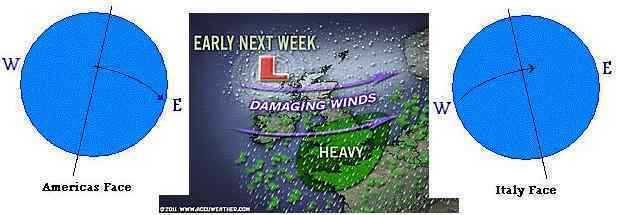
Will this mean continuous hurricane activity along the European coast? This will be the minor effect, as with an increased wobble the storm surge will likewise increase, sending unprecedented high tides into the lowlands of Europe. Well before the 7 of 10 European tsunami Europe will be faced with having to evacuate vulnerable lowlands. The UK obviously takes the brunt of these storms, as has Norway, but it is where the elevation will drive the storm surge over the sea walls that evacuation will begin. London is vulnerable. The Netherlands and Denmark are very vulnerable.
Civil defense exercises by emergency teams to evacuate and rescue people when the surge is in process are only the first step. It is clear that many countries within Europe intend to partner with each other during such a crisis, sending in rescue teams with boats and choppers. But what then? If the lowlands have become unlivable, what then? Cooperation within Europe will be challenged, as no one wants refugees. The welcome that many immigrants have received in the past, when the economy supported job growth, will be withdrawn, often suddenly and rather brutally. If the debt carried by Italy and Greece have become a headache for the European Union, just imagine what drowning refugees from many member countries will entail!
Views: 3209
Comment
-
Comment by Gerard Zwaan on January 6, 2012 at 9:56am
-
Comment by Starr DiGiacomo on January 6, 2012 at 12:46am
-
http://www.weather.com/outlook/weather-news/news/articles/netherlan...
High Water Sparks Dutch Evacuations

A small boat is seen near a road inundated with flood water around the village of Tolbert, northern Netherlands, Thursday Jan. 5, 2012.
THE HAGUE, Netherlands (AP) -- Dozens of farmers were warned to evacuate land north of the Dutch capital Thursday as a dike protecting the area threatened to collapse.
Local mayor Ben Plandsoen told national broadcaster NOS that a polder - reclaimed land that is drained by pumps and mills - would likely be submerged under some 40 centimeters (16 inches) of water if the dike protecting it breaks.
"You just don't know how the dike will hold up," he said. "It is saturated, so you don't know how much pressure it can take."
Elsewhere, riverside residents were offered sandbags, even as the low-lying Netherlands appeared to be largely winning the latest skirmish in its never-ending battle to stay dry.
The densely populated nation of nearly 17 million, 25 percent of which lies below sea level, has been drenched by heavy rain and buffeted by strong northwesterly winds for days.
The rain saturated dikes and filled drainage canals and rivers while gales lashing the coast hampered efforts to pump the excess water out of canals and into the sea.
In neighboring Belgium, newspapers reported that a 64-year-old man died Thursday morning in the town of Roosdaal, about 16 kilometers (10 miles) west of Brussels, when high winds blew a massive door on top of him.
Dutch authorities appealed to the some 85 farmers who keep livestock on below-sea-level land near the village of Tolbert 160 kilometers (100 miles) north of Amsterdam, to voluntarily evacuate because the dike was threatened.
Dutch media reported that most farmers ignored the voluntary evacuation and meteorologists said early afternoon that the worst rainfall appeared to have passed. With less rain and lightning fast winds forecast over coming days, the situation was expected to ease although river levels could rise before then begin to fall.
Even so, the Defense Ministry said it had put 50 troops on standby with inflatable boats, trucks and ambulances in case they were needed in the north.
Authorities also cordoned off river banks in some areas of the densely populated south. In the city of Dordrecht, thousands of sandbags were made available to residents whose homes or businesses were threatened by the rising levels of three rivers.
Television images showed water lapping at windows of houses built next to one of the city's rivers.
Inspectors also patrolled dikes along the Oosterschelde estuary in the south Thursday and along coastal regions in the north as powerful wind gusts battered the North Sea coast, national water authority Rijkswaterstaat said in a statement.
Water authorities further north said early Thursday that the situation there was under control after they pumped millions of gallons of water into the sea, lowering water levels in drainage canals that crisscross the country.
They also deliberately flooded uninhabited nature reserves to lower water levels elsewhere in populated parts of the region.
The Groninger Museum in the city of Groningen was closely monitoring water levels in the moat that surrounds the building.
The museum said in a statement that some of its exhibition halls were threatened, and it was in close contact with water authorities about whether it needs to close and shift some exhibits, including a recently opened show of clothes by Tunisian designer Azzedine Alaia.
No deaths or injuries have been reported in the Netherlands, though the strong winds caused delays at the country's main airport, Schiphol, and on railways.
SEARCH PS Ning or Zetatalk
https://poleshift.ning.com/forum/topics/last-trimester-event-timeline
NEW POLE SHIFT UPDATE!
Awakening to the Alien Presence ZetaTalk
The truth will likely never to be known to the public but be washed away in the Nibiru panic soon to engulf the world.
The Worst of the Cover-Up
https://poleshift.ning.com/profiles/blogs/the-worst-of-the-cover-up
Main Establishment Lies
https://poleshift.ning.com/profiles/blogs/main-establishment-lies
Donate
© 2026 Created by Juan F Martinez.
Powered by
![]()
You need to be a member of Earth Changes and the Pole Shift to add comments!
Join Earth Changes and the Pole Shift