Wild Weather, the Wobble Effect
TOTAL DESTRUCTION IN PARTS OF CEBU CITY, PHILIPPINES, 05.11.25
Massive flooding in Da Nang, Vietnam. 30.10.2025.
Giant waves crash over seawalls during a storm
in the suburbs of Taipei, Taiwan. 21.10.2025
"We warned at the start of ZetaTalk, in 1995, that unpredictable weather extremes, switching about from drought to deluge, would occur and increase on a lineal basis up until the pole shift. Where this occurred steadily, it has only recently become undeniable. ZetaTalk, and only ZetaTalk, warned of these weather changes, at that early date. Our early warnings spoke to the issue of global heating from the core outward, hardly Global Warming, a surface or atmospheric issue, but caused by consternation in the core. Affected by the approach of Planet X, which was by then starting to zoom rapidly toward the inner solar system for its periodic passage, the core was churning, melting the permafrost and glaciers and riling up volcanoes. When the passage did not occur as expected in 2003 because Planet X had stalled in the inner solar system, we explained the increasing weather irregularities in the context of the global wobble that had ensued - weather wobbles where the Earth is suddenly forced under air masses, churning them. This evolved by 2005 into a looping jet stream, loops breaking away and turning like a tornado to affect the air masses underneath. Meanwhile, on Planet Earth, droughts had become more intractable and deluges positively frightening, temperature swings bringing snow in summer in the tropics and searing heat in Arctic regions, with the violence of storms increasing in number and ferocity."
ZETATALK
Wild Weather, the Wobble Effect - Earth Changes and the Pole Shift
Views: 638104
Comment
-
Comment by Howard on July 8, 2014 at 2:05am
-
11 Tornadoes Reported As Storms Rake Iowa (Jul 6)
Tornadoes thrashed across Iowa as another bout of severe weather smashed into the state Sunday evening.
While trees and property suffered, there were no immediate reports of serious injuries or deaths in the outbreak of tornadoes.
Trained storm spotters had reported at least 11 tornadoes touching down across the state at press time Sunday evening, according to the National Weather Service bureau in Johnston.
Spotters logged tornadoes in Jewell, Geneva, Reinbeck, Dysart, Traer, Lincoln, Winterset and Newton. More than one tornado was reported for some locations. Weather service meteorologists will investigate storm damage to confirm the reports today.
"We've got a storm survey team that's going to be going out to just to kind of asses what kind of damage occurred," said Brad Fillbach with the National Weather service. Fillbach said the teams would assess in several counties including Jasper, Tama and Grundy.
Sunday's first funnel cloud twisted near Jewell at 5:55 p.m., quickly turning into a tornado by 6 p.m. Small trees were damaged.
Another tornado touched down near Geneva in Franklin County for about three minutes, storm spotters said.
Spotters reported two tornadoes near Reinbeck in Grundy County.
One home about a mile west of Reinbeck sustained major structural damage, and another across the street had damage to its roof, Chief Deputy Tim Wolthoff of the Grundy County Sheriff's Office told the Associated Press. Both of the homes were occupied, but no one was injured.
Four tornado reports came in from Tama County in a 30-minute span. The first twister landed near Dysart at 8:04 p.m. Another reached the ground near Traer three minutes later. At 8:16 p.m., a storm spotter reported a tornado near Lincoln. The fourth twister was reported at 8:35 p.m., again near Traer.
The Lincoln and Traer tornadoes reportedly carried a lot of debris.
Benton County Emergency Management officials reported a tornado near Keystone at 8:56 p.m.
A tornado was spotted in Jasper County near Newton shortly before 9 p.m. Another tornado touched down near Kellogg in Jasper County about 9:10 p.m.
Sources
http://www.press-citizen.com/story/news/2014/07/07/11-tornadoes-rep...
http://www.kwwl.com/story/25951119/2014/07/06/severe-weather-possib...
-
Comment by jorge namour on July 7, 2014 at 4:44pm
-
The super-typhoon Neoguri approaches to Okinawa with winds of 250 km / h: "Supervision maximum" ---- JAPAN
Monday, July 7, 2014
PHOTO LINK: http://www.meteoweb.eu/2014/07/super-tifone-neoguri-inizia-ad-impre...
A powerful typhoon, the eighth season of the renamed Neoguri, and 'expected in Okinawa, far south of Japan, between late this evening and tomorrow morning with a load of torrential rains and winds of up to 250km per hour. The Japan Meteorological Agency (JMA) is assessing the level of alert in the evening to announce the imminent arrival of the perturbation, moving from south to north, it might be more 'serious of its kind in decades. The issuance of an alarm of "high level", if agreed, would be for the first time since the new system 'was introduced in August 2013. According to the agency, the typhoon will become' more 'always strong in the move towards north, while at the speed 'wind' of about 75 meters per second, while the displacement of the disruption 'of 25km/ora. During a meeting of the government on the situation, the Minister for Disaster Management, Keiji Furuya, who canceled a trip to the U.S. for an event on disaster prevention on the sidelines of a UN meeting, urged the prefectures and municipalities to take the necessary steps and to advise on time, where necessary, evacuations. The government has set up a unit 'link in the middle of Emergency Management Office of the Prime Minister. "It is one of the most looming 'big typhoons ever had in July," he admitted in a press conference Satoshi Ebihara, Head of Section of the JMA weather forecast: in 1959 the Typhoon Ise-wan I cause' 5,000 victims. "And 'required the utmost vigilance," he added, citing the heavy rains and winds, as well as' high waves up to 14 meters. The rainfall may reach a record number of 200 mm in the 24 hours is Okinawa archipelago. Meanwhile, a front of torrential rain is hitting the southern island of Kyushu, where in some areas were measured more 'than 350 millimeters of water. Extraordinary levels that would drive the JMA, to advise extreme caution due to landslides and floods. Also because 'Neoguri will be' on Kyushu tomorrow afternoon.
http://www.meteoweb.eu/2014/07/super-tifone-neoguri-si-avvicina-ad-...
https://translate.google.com/translate?sl=it&tl=en&js=y&...
METEOWEB Saturday, April 5, 2014,
Something very big is beginning to move over the
large strip of very hot water, flowing at a depth of about 150 meters along a route east west.his wave can be observed on the surface by a slight increase in height of the sea surface, about 8 cm, and a significant increase in surface water temperatures over a large area for hundreds of miles
is causing a significant increase in the "thermocline" throughout the Western and Central Pacific, where there is a considerable warming of surface waters, up to 150 meters depth, with values truly exceptional, reaching values of +24 ° C to +25 ° C.
-
-
Multiple Tornadoes, Large Hail Reported in Saskatchewan (Jul 5)
Saskatchewan man shares breathtaking video of massive tornado near Outlook, Saskatchewan on July 5. Although at first it appears to be coming straight for him, it rumbles by without causing damage, although it later destroyed a nearby farm. It grows significantly larger just before the end of the video. (Caution: Audio contains multiple F-bombs.) Source
Residents in parts of Saskatchewan ran for cover, stared in awe or jumped in their trucks to follow what Environment Canada says were several tornadoes that hit Saturday.
The agency issued tornado warnings for numerous areas in southern and central parts of Saskatchewan and southern Manitoba Saturday afternoon, and said there were tornadoes reported near Outlook and Kenaston.
Ray Derdall and his son Carson were working outside their property 20 kilometres north of Outlook Saturday afternoon when a black funnel cloud dropped down. They had almost no time to react.
"Within about 10 seconds, it was right on top of us," Ray said.
"It's so loud and dirty and dusty. You don't know what's going on, you can't see your nose."
Ray ran to the closest shelter - his workshop - while Carson made it to the steel Quonset and crawled under a combine cutter.
"I was just waiting for the whole quonset to lift off and I thought maybe it would suck me out," a visibly shell-shocked Carson recalled. "I thought I was going to die."
Then, less than five minutes after the tornado hit, it was over. Carson emerged unscathed from the battered Quonset to find his father wriggling out from underneath one of the walls that used to hold up the workshop.
Neither was injured, but it became apparent almost immediately that almost everything on their property was destroyed.
"It was just a direct hit. It took a 100-year-old barn that we were fixing up. It took the Quonset and it took the shop. It took the windows out of the house," said Derdall.
"It even sucked the comforters off the beds through the windows and out of the house."
Derdall said miraculously, neither he nor his son were injured.
Shannon Bestland, meteorologist with Environment Canada, said the agency was receiving multiple calls about funnel clouds touching down in south-central Saskatchewan as far south as Regina Beach.
“There are so many, we can’t count them right now,” she said Saturday afternoon.
Baseball-sized hail were also reported in some areas of Saskatchewan, she said.
SaskPower tweeted that tornadoes have caused outages at Davidson, Hanley, Kenaston, Rosedale and surrounding areas.
Derdall said it was his first experience with a tornado, other than seeing them on TV.
"You think it will never happen to you."
Sources
http://www.theweathernetwork.com/news/articles/photos-and-videos-da...
http://www.ctvnews.ca/canada/tornadoes-reported-in-parts-of-saskatc...
http://www.thestarphoenix.com/news/Tornadoes+cause+havoc+Saskatchew...
-
-
Manitoba Declares Rare Province-wide State of Emergency (Jul 4)
The Canadian province of Manitoba has declared a provincial state of emergency amid rising concerns on flooding and has requested military assistance.
Manitoba Premier Greg Selinger said Friday he has asked Prime Minister Stephen Harper to have Canadian Armed Forces soldiers on the ground in Manitoba by Saturday to assist with flood relief efforts.
"We need to be able to take action to protect the safety, health and welfare of Manitobans," said Selinger.
"Declaring a provincial state of emergency will allow us to take steps quickly to protect people and property in the area."
Canadian Forces personnel will work to reinforce the dikes along the Assiniboine River between Portage la Prairie and Winnipeg, where 200 homes are at risk.
They will also help raise the dikes along the Portage Diversion — a 29-kilometre channel that directs some of the flood water from the Assiniboine north to Lake Manitoba.
The regional municipalities of Portage la Prairie, Cartier, St. Francois Xavier and Headingley are the biggest areas of concern. They are being advised to prepare for flood levels more than 30 centimetres (12 inches) higher than those of 2011.
A command centre is being established near Portage la Prairie to assist with liaison efforts between the military and the affected communities, Selinger said.
Floodwaters began washing across a road in Brandon on Friday even though the crest isn't expected to reach the city until this weekend and then Portage la Prairie by July 11.
Steve Topping with Manitoba Water Stewardship called the rate at which the water is flowing "unprecedented."
"Things are ramping up very quickly. This is a fast moving event and we have very good hydrometric gauges that are providing us 24/7 information," he said.
Manitoba is bracing for water flow levels between 48,000 cubic feet per second (cfs) and 52,000 cfs on the Assiniboine River downstream of Portage la Prairie.
The high water levels are expected within the next week and are forecast to remain high for a period of at least three weeks.
The flooding is being caused by torrential rains last weekend in Manitoba and Saskatchewan.
A total of 43 communities in Manitoba and 75 in Saskatchewan are under states of local emergency. Water from Saskatchewan is now flowing into Manitoba, deepening the problem in that province.
Some 565 people have already been forced from their homes in Manitoba due to flooding.
Selinger said the province will work to produce a half-million sandbags — in addition to the two million it already has in stock — to protect the areas most at risk as the crest moves closer.
Sources
http://www.cbc.ca/news/canada/manitoba/manitoba-flooding-province-d...
http://www.theweathernetwork.com/news/articles/rare-province-wide-s...
-
-
Bad weather in Spain, Madrid violent hailstorm Whitening: blocked traffic [PHOTOS and VIDEO]
Thursday, July 3, 2014,
A strong hailstorm has hit the capital of Spain, Madrid, in the early hours of the afternoon (between 15 and 16). The event was so violent as to whiten the streets causing disruption of some major thoroughfares, such as the M-40 motorway huge town that surrounds the city, and the M-11. Even the flights arriving at and departing from Madrid airport at Barajas, have been delayed. At least 4 planes had to postpone the landing due to adverse weather conditions, while several areas of the airport were flooded. The underground line 7, has had to suspend some races between the stations of Cartagena and Las Musas, always to flooding (the races were re-established after 30 minutes).
The hail struck with violence especially the eastern half of the city, particularly in the districts of San Blas, Barajas (where the international airport), Vicalvaro, but also Hortaleza and Fuencarral. The streets were literally whitewashed, to the bewilderment of Madrid who have immortalized the event with photos and video, promptly loaded on social networks. Below is a gallery of pictures from Twitter under the hashtag # granizada, a term which in Spanish means precisely hailstorm.
http://www.meteoweb.eu/2014/07/maltempo-in-spagna-violenta-grandina...
http://www.youtube.com/watch?v=VD8kt2C2Ojc
https://translate.google.com/translate?sl=it&tl=en&js=y&...
Also Hail grandinata ad Almazán in Spagna [FOTO e VIDEO]
http://www.meteoweb.eu/2014/07/le-impressionanti-immagini-della-vio...
http://translate.google.com/translate?hl=en&sl=auto&tl=en&a...
-
Comment by lonne rey on July 3, 2014 at 4:00pm
-
Early signs of autumn 'already appearing in natural world'

Sycamore seeds are well developed and hawthorn berries are already red, says National Trust
After an early spring and summer, the year is now racing towards autumn ahead of schedule, conservationists have said.
As the year reached the half-way mark, the National Trust said wildlife seemed to have come through the wettest and stormiest winter on record and nature had hurtled "helter-skelter" through the seasons since.
Now signs of autumn are already in the hedgerows and woods, National Trust naturalist Matthew Oates said.
"Looking at this year, where does it want to be? It raged its way through winter, then we went into an incredibly early spring, and then it rushed helter-skelter through spring without stopping for breath," he said.
"We're ahead still, remarkably ahead, birds have largely stopped singing, a lot of butterflies are very early and are still coming out early," he said, pointing to early arrivals of high summer butterflies including chalk hill blues and purple emperors.
And he said: "There are really strong signs of autumn already here, like the beech nuts, it's an amazing beech mast year and the nuts are incredibly well developed."
-
-
2 Derechos Spawn 8 Tornadoes in Illinois and Indiana (Jun 30)
The first derecho over Iowa as of 1:45 p.m. ET June 30, 2014.
Two separate derechos affected the Chicago area Monday night resulting in eight tornadoes that touched down in the Chicago area and Northwest Indiana.
The two-fisted storm that pummeled the Chicago area this week has been classified as a rare double derecho: Two waves of destructive winds that swept across a swath of the Midwest from central Iowa to Ohio. The fast-tracking storm generated widespread wind gusts of 70-80 mph, left three quarters of a million without power, and caused two fatalities.
The first derecho formed around 2 p.m. Monday in Iowa and sped across northwest Illinois into Wisconsin over the next five hours, packing winds of more than 55 mph, according to the National Weather Service.
The second derecho also formed in Iowa, but a little more to the south and six hours later, heading almost straight east toward Chicago, the weather service said. The winds were clocked at more than 60 mph with gusts up to 70 mph.
This second wave produced eight tornadoes that touched down in northern Illinois, including one between Plainfield and Romeoville, the weather service said. No injuries were reported, but hundreds of trees were downed and nearly 200,000 customers lost power.
A derecho is a wind storm that stretches more than 240 miles and is punctuated by wind gusts of more than 55 mph. They are relatively uncommon and a double derecho is even rarer, though another one did occur here as recently as 2010, according to weather service meteorologist Ricky Castro.
What makes Monday's double derecho even stranger is that the second wave was stronger than the first. It's generally the other way around.
"Usually, the first one stabilizes the atmosphere and makes it less likely for thunderstorms to occur," Castro said. But this time, "the first derecho was less intense and the second one was violent and spawned tornadoes."
The National Weather Service said brief EF-1 tornadoes landed late Monday near Earlville, about 80 miles southwest of Chicago; near Romeoville and Plainfield in Will County; near Lisbon in rural Kendall County; three tornadoes were near Grant Park in Kankakee County. In Indiana, one tornado was confirmed in Lowell and another near DeMotte.
Sources
http://abc7chicago.com/weather/nws-8-tornadoes-confirmed-in-chicago...
http://www.chicagotribune.com/news/local/breaking/chi-onetwo-punch-...
http://www.washingtonpost.com/blogs/capital-weather-gang/wp/2014/07...
http://www.weather.com/news/derecho-and-severe-storms-cause-damage-...
-
Comment by KM on July 1, 2014 at 11:03pm
-
http://www.inthesnow.com/resorts/heavy-snow-brings-july-joy-australia/
HEAVY SNOW BRINGS JULY JOY IN AUSTRALIA
RESORTS NEWS 1 JULY 2014
Australian ski areas – which started their season badly on June 7th with almost no snow following a record warm May, are celebrating snowfalls of up to almost five feet (1.4m in fact) during the last four days.
The snow has now stopped leaving resorts well-covered ahead of the weekend and the country’s school holiday period.
“We expect to have over 40 lifts operating for the weekend across the four resorts areas of Perisher, Smiggin Holes, Blue Cow and Guthega,” said Samantha Hales, Communications and Media Manager at Australia’s biggest resort which now has a 102.1 cm base,
“There is a lot of work to do to get the resort open after a big storm as we need to get out there and groom out the wind drift, build lift tracks and ensure the resorts is safe for guests.”
Meanwhile at Mt Hotham called the snowfall ‘Snowmageddon 1.0’ and are expecting ‘Snowmageddon 2.0’ to follow bon later this weekend,
“Snowmageddon 1.0 started last Monday and brought the snowfall we have all been waiting for. Within 3 days we had over 70cm of snow, got 6 lifts going and are looking forward to the best school holiday skiing and riding in years. Another front is coming in on Saturday and we will be hitting the 1-meter mark by Saturday night/Sunday morning,” said a statement from the resort, which currently has seven lifts running.
-
-
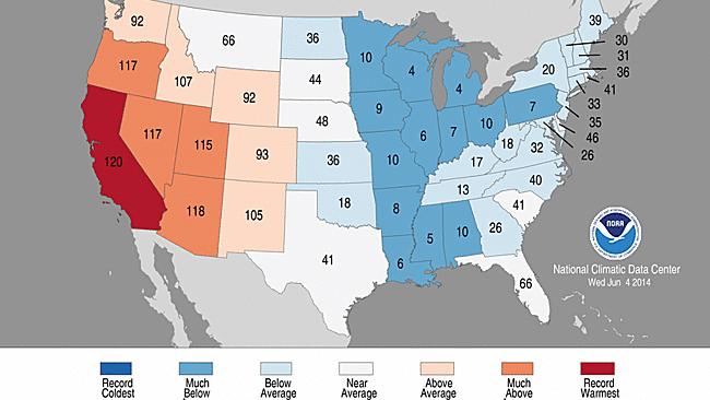
California's Record Hottest Year, So Far, Is 2014: NOAA
California is sweating through its hottest year-to-date in 2014, according to a just-released report.
 means 2014 was the hottest January-May period on record. Conversely, a ranking of 4 (Wisconsin) means the fourth coldest such period on record, dating to 1895. (NOAA/NCDC)")
Statewide temperature rankings for the period January-May 2014. A ranking of 120 (California) means 2014 was the hottest January-May period on record. Conversely, a ranking of 4 (Wisconsin) means the fourth coldest such period on record, dating to 1895. (NOAA/NCDC)
The first five months of 2014 were the hottest on record in the Golden State, according to the May U.S. State of the Climate report from NOAA's National Climatic Data Center, in records dating to 1895.
California's mean January-May temperature of 55.2 degrees was a whopping five degrees above their 20th Century average, topping the previous hottest January-May period there set in the Dust Bowl era (1934).
Los Angeles, San Francisco, San Diego, Fresno and Sacramento all set their record hottest January through May.
Persistent blocking high pressure in the upper atmosphere diverting the jet stream north of the Golden State is the primary factor behind a hot 2014, not to mention one of the worst droughts in decades.
(MORE: Record Dry 2013 | Drought Threatens Food Supply)
")
Selected cities recording their top three warmest, coldest, wettest or driest January-May in 2014. (NOAA/NCDC)
Notable Heat Elsewhere
Arizona, Oregon, Nevada and Utah also chalked up a top 10 warmest January-May period in 2014.
Las Vegas, Phoenix and Tucson have each registered their hottest year-to-date through May. The year has been among the top three hottest in Salt Lake City, Flagstaff, Arizona, and Medford, Oregon. (see red dots on inset map at right)
Impressive warmth in 2014 extended into the Last Frontier.
The year's first five months were the second warmest such period on record in Alaska, exceeded only by January-May 1981. America's northernmost city, Barrow, Alaska, has had its record warmest January-May.
Not Just the Heat
In parts of the central and eastern U.S., the first five months of 2014 were a completely different story.
Thirteen states from Minnesota to Louisiana east to Pennsylvania shivered in a top 10 coldest January-May on record (see first inset map above).
Chicago, Buffalo, Indianapolis, Toledo, Green Bay, Wisconsin, even the nation's icebox, International Falls, Minnesota chalked up a top three coldest January-May periods in 2014 (see second inset map above for more cities denoted by blue dots).
On the dry side, January through May was the second driest such period on record in Kansas, third driest in Oklahoma and fourth driest in Arizona.
Source: http://www.weather.com/news/science/california-record-hottest-year-...
-
-
Waterlogged Canadian Prairies: 150+ mm of Rain Prompts Evacuations, Local States of Emergencies (June 30)
Days of torrential downpours across parts of the Prairies have resulted in evacuations and local states of emergencies. In Saskatchewan, 53 communities have declared local states of emergency while in Manitoba, 34 municipalities have done the same.
The hardest hit areas include communities along the Saskatchewan/Manitoba border where between 100-200 mm of rain has been recorded since Friday.
Several main highways and secondary roads remain closed and officials say water also covers stretches of the Trans-Canada Highway west of Brandon, Manitoba.
Flights at Brandon's airport have also been disrupted after the facility's main access road was flooded.
Residents are being urged to delay showers, baths, and even flushing toilets to prevent additional strain on the water systems.
In addition to the flooding rains, damaging winds that whipped through Manitoba left hundreds of homes without power over the weekend.
According to hydro spokesperson Scott Powell, they've been overloaded with calls throughout southern Manitoba and the Interlake region, with power lines affected in both urban and rural areas.
Sources
http://www.theweathernetwork.com/news/articles/waterlogged-prairies...
http://www.cbc.ca/news/canada/manitoba/prairie-flooding-prompts-eva...
http://www.theweathernetwork.com/news/articles/ten-photos-flooding-...
SEARCH PS Ning or Zetatalk
Donate
© 2025 Created by 0nin2migqvl32.
Powered by
![]()
You need to be a member of Earth Changes and the Pole Shift to add comments!
Join Earth Changes and the Pole Shift