New Madrid Jolt timeline
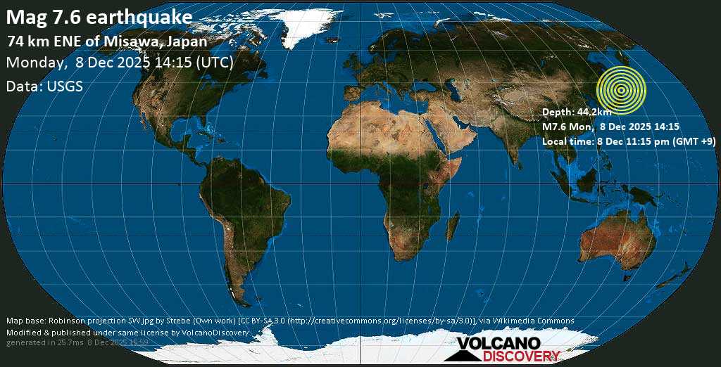
Major mag. 7.6 Earthquake - Aomori, 320 km north of Sendai, Miyagi, Japan, on Monday, Dec 8, 2025
Nancy Lieder / ZetaTalk: New Madrid Adjustment
New Madrid
There has been much made of an earthquake in the recent past long the New Madrid fault line, as this was unexpected, being in a quiescent area, and thus raised all manner of questions regarding the possibility of massive earthquakes in areas presumed to be safe. Simply put, there are no earthquake free areas, and during the coming pole shift, all parts of the globe will be subject to them, without exception. Thus, individuals living in areas which have never experienced an earthquake should not presume safety but should take the same steps in preparing for the pole shift that those living atop highly active fault lines take - stay out of old or masonry buildings, and anticipate earthquakes as severe as any that mankind has ever experienced and noted.
ZetaTalk ™
Our description on the pole shift itself describes not a single jolt when the crust stops moving but a series of jolts. Most severe earthquakes are like this, in fact, if one examines their pattern. There are small quakes ahead of time, swarms, and jiggling that unsettles people as they sense something is pending. Then when the rock fingers that are preventing the fault line from sliding or subducting suddenly break, a large jolt. This often, within minutes, results in more jolts as the pressure that was at one point now moves to be pressure at the next point where rock fingers are holding the slippage. Aftershocks result, as yet more rock fingers break, until a point arrives where there is so much resistance to slippage that the quake and its after effects is considered complete.
For the New Madrid, which will include the European tsunami in its effects, there will be one large jolt with a subsequent and almost immediate tearing of the Atlantic. We have stated that the European tsunami will be the largest, but smaller ones will follow in time. Likewise for the New Madrid adjustment, which involve a tearing of the entire N American continent from the seaway down to Mexico. This adjustment will not occur until minor rock fingers have been steadily broken in a number of places. The areas to be affected have already been experiencing quake swarms, buckling roadways, sinkholes, breaking dams, and unsettling jigging which is unexplained by the authorities. When the primary blockage gives, there will be a huge jolt, with little warning. Aftershocks will continue until the time of the pole shift itself.
ZetaTalk ™ 2010
Views: 522067
Comment
-
Comment by Kojima on May 6, 2023 at 10:37am
-
SO2-US, SO2-China, CO-China
2023/05/05 T00:00 - 2023//05/06 T00:00
-
Comment by Nancy Lieder on May 5, 2023 at 7:31pm
-
Oh May 5 the Triangle between Japan, Beijing, and Taiwan that was outlined last November is showing up as stress SO2 off the coast of China there. Along with big quakes in Japan.
-
-
SO2-US, SO2-China, CO-China
2023/05/04 T00:00 - 2023//05/05 T00:00
-
-
On May 4, it is Day 3 since earthquake have arrived and risen toward Beijing along the China Fault Lines predicted to trigger a large China quake which will trigger all the Plate Movements that will ignite the New Madrid Rupture. In China, the province that contains the 3 Gorges Dam is increasingly restless. Meanwhile the Mainland continues to drop on Mexico, heavily, with the only Heliplots solid black on the Mainland.
ZetaTalk Prediction March, 2023 (http://www.zetatalk.com/ning/31mr2023.htm)
Last November when we relayed the telepathic message that those in Japan, Taiwan, and Beijing received during their simultaneous UFO displays, we were describing a large quake in China that was to occur, described by us as an “explosion”. How and where this quake was to occur was not explained. Now it seems to be obvious, as on March 26 there are quakes surrounding the Sunda Plate and wrapping up into central China all the way to Mongolia.
The Sunda Plate is considered part of the great Eurasian Plate, but like many platelets it has the potential of operating on its own. Given the large quake in the Himalayas on March 22 just days earlier, it was clear that the Indo-Australian Plate had moved and a domino effect always follows when this plate plunges and tilts. The Sunda Plate is breaking from the Eurasian Plate with this snap destabilizing the central China Wudu-Mabian fault line and reaching up along this fault line to the Yanshan Mountains seismic zone which touches Beijing.
This portends the explosion we referred to during our UFO analysis last November. If the Sunda Plate was to break from the Eurasian Plate, this would free China to jump to the East into the Pacific. This would indeed push and twist Taiwan in a counterclockwise manner. By compressing the Northern Pacific the bulbous top of S America would temporarily shift into the widening Atlantic, giving the SE Portion of N America room to drop so its hook-like connection to the Isthmus is freed. This thus would be the trigger for the New Madrid timeline to complete.
-
-
SO2-US, SO2-China, CO-China
2023/05/03 T00:00 - 2023//05/04 T00:00
-
-
If quakes along China's major Fault Line appeared on May 2, by May 3 they had continued and crept further up toward Beijing. The 3 Gorges Dam is not yet threatened by quakes. But these are major developments. The Sunda Plate continues to show signs of snapping off to separate from the Eurasia Plate, which will allow China to lurch East into the Pacific. And the Mainland drop onto Mexico has also intensified.
-
-
The ZetaTalk Newsletter; Issue 245, Sunday June 12, 2011
Plates on the Move
https://www.zetatalk.com/newsletr/issue245.htm
The 7 of 10 scenarios are all about plate movement. Where the big drama is in Indonesia and mountain building in the Andes, plate movement is perceptible elsewhere and indicative of the 7 of 10 scenarios to come and in process. As the African Plate starts to roll and drop, this would begin to separate the Straits of Gibraltar and stretch the distance between the Egyptian side of the Red Sea from the Sinai. It would also start to roll the Arabian Plate, where the pointed top of this plate cuts from west to east, stressing the Eurasian Plate above this slicing point. Is this happening? We find a sinkhole in Eskisehir, Turkey, where sinkholes are virtually unknown. As the pointed top of the Arabian Plate moves from west to east, it would pull this area, stretching it, the most common cause of sinkholes. Dropping to Cairo we find sinkholes also, not far from the river Nile. Cairo also does not prone to sinkholes, but as the Red Sea pulls apart, this area would indeed be stretched and river bottoms are a thin place on the plate, thus drooping to form a river bottom in the first place. Dropping further along the African Plate, we arrive at Pemba, a tiny island just off the east coast of Africa. Pemba has a very low elevation, 50 meters the highest point, but this would not account for the seawater now flooding homes and fields. Africa's Rift Valley widens as Africa rolls, the whole southeastern side loosing its base as it does so, drooping. Pemba is just to the east of the Rift Valley.
The Zetas have called the plunging of the Indo-Australian Plate the brake point holding all other plate movement back. As the plate tips up at the New Zealand side, it plunges India under the Himalayas, allowing the Pacific to compress and the Sunda Plate tongue holding Indonesia to plunge under the curve of the Indo-Australian Plate. Has the India side of the plate been plunging? Bangledesh and Kuttanad on the tip of India are sinking, and in the eastern Himalayas, mountain building is taking place, heaving river bottoms and preventing drainage. Suddenly, and with scant rain, Jorhat is under water!
Moving east along the globe we find the line across the South China coastline, where the plate tongue holding Indonesia is bent down to be pushed under the curve in the Indo-Australian Plate. Ground fractures when such a bend in the rock occurs. Draw a line from where the Philippine Plate is being pushed against the coastline of China, west, and the line runs through Guangzhou and City of Guiyang! The Philippine Plate is tilting, pushing under the Philippine Islands, as part of the compression of the Pacific.
Moving further east to the Americas, where the N American continent is under a bow stress - the Aleutian Islands being pulled toward the tip of Mexico which is tugging west. What does an earthworm plague in Cincinnati, a 100 year old house suddenly dropping into a sinkhole in Clinton, Iowa, and sinkholes in Quebec have in common? All these spots are along rivers! Earthworms will come to the surface to mate, and signal each other by a type of vibration called drumming. Rock under stress also vibrates. Certainly for a house that has stood for 100 years to suddenly find its foundation infirm is suspect. Ground movement is the likely culprit, and the Mississippi will be ripped open during the coming New Madrid adjustment, and Cincinnati on the Ohio River will also be affected. Clearly, the Seaway is being pulled open, and to the west of this rip we have British Columbia, where a landslide occurred at Hope. All of these seemingly unrelated incidents are related.
==================================================
Indonesia Elevation Loss
https://www.zetatalk.com/info/tinfx341.htm
We have spoken previously of the areas to be affected by the bending of the tongue holding Indonesia, but can now give more specifics. Draw a line from the city of Hangzhou directly east, and consider this horizontal line the point of bend. This does not mean that points north can rest easy, as when the tongue bends down water from various sides will rush in to fill the void, and these waters will have a rebound in the form of tsunami which can race northward at a height of 20-30 feet. The southern coast of China was likewise warned that they could experience loss of elevation. How much will their coastline drop, that they needed this warning from the Hangzhou UFO? This coastline, in general, can anticipate losing 20 feet in elevation, which will likewise afflict Taiwan though Taiwan is high land and will not be as devastated.
Thought the tipping of the Philippine Plate at first gives the islands of the Philippines some relief, as the subduction of the plate is pushing under them, as the bending of the tongue holding Indonesia progresses, they too find an astonishing loss of sea level. However, other than some small islands and the direct coastline, little of the Philippines will be affected by this rise in sea level, and safety can be gained if the coastal residents head for the hills at the first sign of sinking. Tsunami will affect the Philippines, to a potential height of 40 feet, so a prompt evacuation to be at least 20 miles inland is necessary. If the coast of southern China will lose 20 feet in elevation, the Philippines will ultimately lose twice that much, to a total loss of 40 feet in elevation. Due to the tilting of the Indo-Australia Plate, Bangladesh gains temporary relief from the steady sinking it has experienced the past few years. And the tsunami likely to race northward will not come their way because the waters from the Bay of Bengal will be rushing into the South China Sea, and there clashing to push north. If the loss of 40 feet in elevation is not devastating to the Philippines, it is to the coastline of southern Burma, Tailand, and Cambodia, which have vast areas that will suddenly and permanently be flooded.
It is the southern tip of the tongue which is utterly devastated. Draw a line just north of the Malaysia border and over the top of Borneo. The land on the tongue from this point south will double its elevation loss, so that Java and the islands bordering the Banda Sea will find they have lost a full 80 feet in elevation, sinking many coastal cities and small islands out of sight. Singapore will be awash, its streets hopelessly inundated. Vast areas of the northern coastline of Sumatra and the southern coastline of Borneo will likewise be inundated. And if having the sea rush in were not horrific enough, the sudden drop in elevation will bring with it water from the Indian Ocean and the Philippine Sea which will create turmoil, unpredictable waves that clash and boil. There is no predictor indicating that the bend and drop are about to happen that we could point to. There are, as we mentioned there would be, indicators of the direction that the plates are being pushed, as Jakarta has been sinking, Pakistan sinking, and the Coral Sea floor rising. We are telling you your coastlines are not safe, and the rest is up to you!ZetaTalk ™ October 16, 2010
^^^^^^^^^^^^^^^^^^^^^^^^^^^^^^^^^^^^^^^^^^^^^^^^^^^^^^^^^^^^^^
Though the Indo-Australian Plate is sometimes referred to as two separate plates, this plate operates as one and will continue to do so. Where Indonesia at the southern edge will lose approximately 80 feet in elevation, the curve of the Indo-Australian Plate nestling this southern edge of the tongue will not gain that much in elevation. Bangladesh will find some of its recently submerged islands suddenly reappearing, and the tides will not roll inland as far as formerly. Overall, perhaps a 15 foot gain in elevation, though this is short term as the continent of India will continue to submerge as time marches on toward the pole shift. What occurs in the pushing down of the tongue holding Indonesia is a drama occurring under the water, in the main. One can see from elevation or relief maps that the submerged land to the south of Sumatra and Java are not under deep, but under relatively shallow water. We have described Sumatra and Java as land formed by the scraping of the tongue holding Indonesia, and pushed back along the tongue holding Indonesia by the edge of the Indo-Australian Plate. This will again occur, but as the tongue overall is pushed down, the scrapings will not produce new mountain ranges above the waves but only jumble under the waves. The western edge of India, where the Indus River region in Pakistan is sinking, will likewise not experience that much loss of elevation, commensurate with the eastern edge of India, perhaps a 10 foot drop. What is occurring in India is not where the 7 of 10 action will be focused, at least not in the public eye.
ZetaTalk ™
^^^^^^^^^^^^^^^^^^^^^^^^^^^^^^^^^^^^^^^^^^^^^^^^^^^^^^^^^^^^^^
Tsunami and eventual sea level loss are not the same thing, although we have predicted a potential tsunami for the Philippines of 40 feet, and this is our estimate for their eventual elevation loss also. The Mentawai Islands and the leading edge of Sumatra and Java will not experience tsunami, though the water rushing inland may clash and boil. If you place a plate in a bathtub, and push it gently down, water will come from all directions onto the plate, but a tsunami wave is not generated. We have stated that a tsunami during the sinking of Indonesia will race north. There will be a clash of this water pouring in from the Bay of Bengal into the South China Sea, which will go in the direction of least resistance. Since the water is coming from the Bay of Bengal, pouring over the lowering plate, it will not push back against this flow. Water from the Pacific will have poured into the South China Sea as it is lowered.
Where is the clash point? Push that plate in the bathtub again, this time tilting one side. The bathwater pours in strongly into the down side, and when water from the other sides pours in, there is a clash and boil in the center, a rebound toward the upside of the plate which has less elevation loss. This is the South China Sea which will have water coming in primarily from the Pacific, which is not blocked by island chains as is the Bay of Bengal. This water will pull in between the Philippines and Borneo, through the Philippines, and clash with water coming from other directions. In such a case, there is a rebound, toward the north, thus a tsunami toward the China coast. Where we have estimated an eventual elevation loss for the south China coast of 20 feet, their tsunami, which could occur repeatedly during the time required for the sinking of Indonesia to complete, could be as high as 35 feet.ZetaTalk ™ December 18, 2010
^^^^^^^^^^^^^^^^^^^^^^^^^^^^^^^^^^^^^^^^^^^^^^^^^^^^^^^^^^^^^^
The 7 of 10 will unfold but not as expected by many. It will not be a dramatic announcement on the news, as the establishment is ready for this, due to the extensive discussions. This is why Mary the psychic stated that after the first of the year Nancy would be held in greater regard and given credit. As we stated, there would be large quakes when Indonesia sinks but not the major quakes one would expect, not magnitude 8-9. Already there are many periods when quakes line the plate borders, and hammer there. During one such episode, the elevation will start to drop. We have never stated, in our predictions, how fast this would go, just said "suddenly". The start will be sudden, almost without warning, but the progress not swift as in the pole shift hour. It will be a steady sinking, in short bursts, over a 2-3 week period. S America will be right behind Indonesia in this regard, starting its roll. This will start slowly at first, the trend already noted, but the quakes starting to pick up as Indonesia sinks. Thus it will not be before the early part of 2011 before the full impact of the prediction accuracy is noted by the world. Meanwhile, the establishment will try to cover with lots of talk about storm surge, Global Warming, and high tides.
ZetaTalk ™ December 18, 2010
^^^^^^^^^^^^^^^^^^^^^^^^^^^^^^^^^^^^^^^^^^^^^^^^^^^^^^^^^^^^^^
We did predict, in our 7 of 10 predictions for the sinking of the plate tongue holding Indonesia, that tsunami would rush against the Philippine Islands and the southern coastline of China. This was predicated on the assumption that sinking would start and continue unabated, completing in 2-3 weeks. In that scenario, a void would be created in the South China Sea, pulling water in from the Bay of Bengal as Sumatra and Thailand and Malaysia sank. This would clash with water pouring in from the Pacific, and rebound northward. These waters would not rebound to the south, as water would also be pouring in from the direction of Australia, around the sinking island of Java.
We predicted the possibility of a 40 foot tsunami in the Philippines, which in any case was estimated by us to lose 40 feet in elevation. The southern coastline of China, and Hong Kong, are estimated to lose 20 feet in elevation, and presumably could expect a 20 foot tsunami. It would be less than that, as the surge would lose momentum and height as it moved north. What is the situation now that plate undulation has slowed the sinking pace? Such tsunami could still occur, as our prediction has been and still is that the sinking will increased in severity and speed as it progresses. The tsunami activity would presumably be less, given that plate undulation now regularly interrupts the process. Given the variety of factors now in play, we declined to be precise in our predictions on tsunami size for the Philippines and the coast of China. Suffice it to say that it will not be greater than our original predictions.ZetaTalk ™ March 19, 2011
^^^^^^^^^^^^^^^^^^^^^^^^^^^^^^^^^^^^^^^^^^^^^^^^^^^^^^^^^^^^^^
See India 7 of 10 Tilt commentary.
India 7 of 10 Tilt
https://www.zetatalk.com/info/tinfx348.htm
Though the Indo-Australian Plate is sometimes referred to as two separate plates, this plate operates as one and will continue to do so. Where Indonesia at the southern edge will lose approximately 80 feet in elevation, the curve of the Indo-Australian Plate nestling this southern edge of the tongue will not gain that much in elevation. Bangladesh will find some of its recently submerged islands suddenly reappearing, and the tides will not roll inland as far as formerly. Overall, perhaps a 15 foot gain in elevation, though this is short term as the continent of India will continue to submerge as time marches on toward the pole shift. What occurs in the pushing down of the tongue holding Indonesia is a drama occurring under the water, in the main.
One can see from elevation or relief maps that the submerged land to the south of Sumatra and Java are not under deep, but under relatively shallow water. We have described Sumatra and Java as land formed by the scraping of the tongue holding Indonesia, and pushed back along the tongue holding Indonesia by the edge of the Indo-Australian Plate. This will again occur, but as the tongue overall is pushed down, the scrapings will not produce new mountain ranges above the waves but only jumble under the waves. The western edge of India, where the Indus River region in Pakistan is sinking, will likewise not experience that much loss of elevation, commensurate with the eastern edge of India, perhaps a 10 foot drop. What is occurring in India is not where the 7 of 10 action will be focused, at least not in the public eye.
We have predicted that the western edge of India will only lose 10 feet of elevation during the 7 of 10, and given the degree of flooding that Pakistan is already experiencing, Karachi has already experienced some of this elevation loss. The flooding in Pakistan, however, is afflicting the Indus River valley to the east of Karachi at this time, on that portion of Pakistan lying on the plate holding India. When the tongue holding Indonesia drops, Karachi will experience great quakes and crumbling, but overall this city will not sink.
ZetaTalk ™
-
-
SO2-US, SO2-China, CO-China
2023/05/02 T00:00 - 2023//05/03 T00:00
-
-
On May 2 a surprise developed at the start of the major Fault Line in China! Quake swarm, above Thailand and in China lands. This leading into the big China quake for sure. Which like the Turkey quakes may be a series of big ones.
-
-
On May 2 the Mainland continues to drop heavily on Mexico and the Cocos Plate. Washington State the only solid black Heliplot on the globe. And look at how jittery the Western half of the N American Continent is!
SEARCH PS Ning or Zetatalk
Nancy Lieder, Emissary of the Zetas.
https://poleshift.ning.com/xn/detail/3863141:Comment:1168188
Awakening to the Alien Presence ZetaTalk
The truth will likely never to be known to the public but be washed away in the Nibiru panic soon to engulf the world.
The Worst of the Cover-Up
https://poleshift.ning.com/profiles/blogs/the-worst-of-the-cover-up
Main Establishment Lies
https://poleshift.ning.com/profiles/blogs/main-establishment-lies
Donate
© 2025 Created by 0nin2migqvl32.
Powered by
![]()
You need to be a member of Earth Changes and the Pole Shift to add comments!
Join Earth Changes and the Pole Shift