New Madrid Jolt timeline
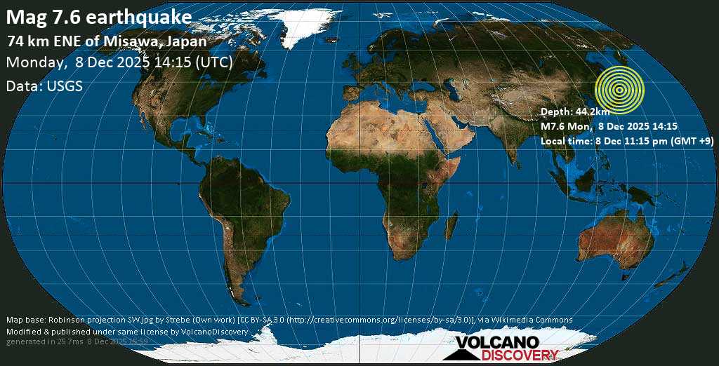
Major mag. 7.6 Earthquake - Aomori, 320 km north of Sendai, Miyagi, Japan, on Monday, Dec 8, 2025
Nancy Lieder / ZetaTalk: New Madrid Adjustment
New Madrid
There has been much made of an earthquake in the recent past long the New Madrid fault line, as this was unexpected, being in a quiescent area, and thus raised all manner of questions regarding the possibility of massive earthquakes in areas presumed to be safe. Simply put, there are no earthquake free areas, and during the coming pole shift, all parts of the globe will be subject to them, without exception. Thus, individuals living in areas which have never experienced an earthquake should not presume safety but should take the same steps in preparing for the pole shift that those living atop highly active fault lines take - stay out of old or masonry buildings, and anticipate earthquakes as severe as any that mankind has ever experienced and noted.
ZetaTalk ™
Our description on the pole shift itself describes not a single jolt when the crust stops moving but a series of jolts. Most severe earthquakes are like this, in fact, if one examines their pattern. There are small quakes ahead of time, swarms, and jiggling that unsettles people as they sense something is pending. Then when the rock fingers that are preventing the fault line from sliding or subducting suddenly break, a large jolt. This often, within minutes, results in more jolts as the pressure that was at one point now moves to be pressure at the next point where rock fingers are holding the slippage. Aftershocks result, as yet more rock fingers break, until a point arrives where there is so much resistance to slippage that the quake and its after effects is considered complete.
For the New Madrid, which will include the European tsunami in its effects, there will be one large jolt with a subsequent and almost immediate tearing of the Atlantic. We have stated that the European tsunami will be the largest, but smaller ones will follow in time. Likewise for the New Madrid adjustment, which involve a tearing of the entire N American continent from the seaway down to Mexico. This adjustment will not occur until minor rock fingers have been steadily broken in a number of places. The areas to be affected have already been experiencing quake swarms, buckling roadways, sinkholes, breaking dams, and unsettling jigging which is unexplained by the authorities. When the primary blockage gives, there will be a huge jolt, with little warning. Aftershocks will continue until the time of the pole shift itself.
ZetaTalk ™ 2010
Views: 522829
Comment
-
Comment by Nancy Lieder on September 24, 2023 at 1:50pm
-
Would the Zetas care to comment on New Orleans saltwater intrusion?
[and from another]
Google Earth readings for September 9:
“Everyplace else lost elevation from Aug:
Merida, Yucatan -38',
Chicago -587,
'Thebes. Ill. -418',
Pine Bluff, Ark -216',
Lafayette, La -29',
Evansville, Ind -373',
New Madrid, Mo -297' “
[and from another]
Saltwater Intrusion in Mississippi River could Impact Drinking Water in Louisiana
September 23, 2023
https://abcnews.go.com/US/salt-water-intrusion-mississippi-river-im...
New Orleans Mayor LaToya Cantrell has signed an emergency declaration over an intrusion of saltwater into the Mississippi River that officials say could impact the water supply in the region.
[and from another]
Water Levels on the Mississippi River are Plummeting for the Second Year in a Row
September 21, 2023
https://www.cnn.com/2023/09/21/us/mississippi-low-water-levels-drou...
The low water levels have made a unique rock formation in the Mississippi River, usually surrounded by water, accessible by foot, and the Army Corps of Engineers is increasing the size of a levee in Louisiana to prevent saltwater from surging into drinking water in New Orleans.SOZT
In describing the 7 of 10 Plate Movements in 2010 we explained that the New Madrid Adjustment would result in the SE Portion of N America bouncing up and moving toward the Northeast, while the Mainland Portion pulls down and to the Southwest. As can be seen by the SO2 Methane emission maps, the SE Portion and Mainland Portions are being pulled apart. How does one confirm that elevations are dropping throughout the Mainland? Satellite readings confirm the drop, and a lower elevation on the western side of the lower Mississippi River also confirms the drop. How else is seawater from the Gulf flowing North up the Mississippi River?
EOZTPrior ZT: http://www.zetatalk.com/ning/30sp2023.htm
We have explained the S America waggle as occurring as the S Pacific compresses, forcing S America to lean back into the Atlantic rather than its normal lean into the Pacific. A waggle thus allows the SE Portion toe to escape over the hump of the Caribbean Plate, expediting the New Madrid Rupture process. S America is currently in a perpetual waggle. Meanwhile the waggle also allows the Mainland Portion of the US to drop down upon Mexico and the Cocos Plate, in essence trapping the Caribbean in a waggle state. To ease the pressure on Central America, a hook of the Nazca Plate is preparing to snap off and become a platelet.
-
Comment by Kojima on September 23, 2023 at 11:30am
-
SO2,CO-World,
CO-US/FarEast-China,
SO2-Bridge
CO-Africa/S America
CO-WestEurasia
CO-India-SE Asia/Australia
2023/09/22T00UTC-09/23T00UTC
-
-
On September 22 an article appeared about the Mississippi River water level dropping. This is a trend predicted by the Zetas due to the anticipated Mainland drop pulling the land down, especially along the western shores of the Mississippi. As this Newsletter detailed. (https://www.zetatalk.com/newsletr/issue862.htm) One can see the distress in the Mainland Portion which has more jittery sites on the Heliplots than any other area on the globe.
Water levels on the Mississippi River are Plummeting for the Second Year in a row
September 21, 2023
https://www.cnn.com/2023/09/21/us/mississippi-low-water-levels-drou...
The low water levels have made a unique rock formation in the Mississippi River, usually surrounded by water, accessible by foot, and the Army Corps of Engineers is increasing the size of a levee in Louisiana to prevent saltwater from surging into drinking water in New Orleans.ZetaTalk 8/16/2006: https://www.zetatalk.com/index/zeta313.htm
What does this do to the N. American plate? It pulls it at a diagonal, ripping the rock fingers along the New Madrid fault such that the land to the East of the Mississippi moves up and to the East, toward New England, and the land to the West of the Mississippi moves down and to the West. This does more than tear most of the bridges along the Mississippi.
-
-
On September 22 the China Observer posted a video about the many quakes China has experienced from June to September. Movement seems constant. We here on the JOLT blog have been tracking the Ching Belly blowout but the media in China is suppressed. So this confirmation is welcomed.
In Beijing, Shanghai, and Shandong, Earthquakes Struck Four Areas Within a Day. Divine Fury?
https://www.youtube.com/watch?v=xD8LtUbhKyE
-
-
SO2,CO-World,
CO-US/FarEast-China,
SO2-Bridge
CO-Africa/S America
CO-WestEurasia
CO-India-SE Asia/Australia
2023/09/21T00UTC-09/22T00UTC
-
-
SO2,CO-World,
CO-US/FarEast-China,
SO2-Bridge
CO-Africa/S America
CO-WestEurasia
CO-India-SE Asia/Australia
2023/09/20T00UTC-09/21T00UTC
-
-
On September 21 we see the effects of the S American waggle. A massive quake swarm along the Nazca Plate border in the Pacific. The waggle allows the Toe of the SE Portion to pull away. This activity can be seen by the number of deep quakes on the Toe, where the ripping is most intense.
-
-
On September 20 a spot of SO2 methane burn appeared along the soft rock reaching up toward the Bridge. Soon the ZetaTalk team noted a surveillance plane coming over this region. Per the Zetas, the hard rock Bridge connecting the Ozarks with the Appalachian Mountains must give to allow the New Madrid Rupture to complete. This SO2 Methane release from ripping rock was occurring in the soft rock that reaches up toward the Bridge. But this is a sign that the unzipping of the Portions, coming up the Mississippi River from New Orleans, is making progress.
-
-
SO2,CO-World,
CO-US/FarEast-China,
SO2-Bridge
CO-Africa/S America
CO-WestEurasia
CO-India-SE Asia/Australia
2023/09/19T00UTC-09/20T00UTC
-
-
Is pumping up groundwater really the cause? According to ZetaTalk, as the New Madrid Adjustment progresses, the Mainland Portion of the US will be dropped down upon Mexico and the Cocos Plate, toward the southwest.
^^^^^^^^^^^^^^^^^^^^^^^^^^^^^^^^^^^^^^^^^^^^
https://www.businessinsider.com/american-southwest-mile-long-cracks-pumping-groundwater-2023-9
The US has pumped so much groundwater that it's literally splitting the ground open across the American Southwest
Maiya Focht and Sebastian Cahill Sep 12, 2023, 2:11 AM JST
A fissure tears open earth and roots in North Sulphur Springs Valley, Arizona. Joesph Cook/AZGS
The United States has been pumping so much groundwater it's splitting the ground open.
The giant cracks occur when the ground sags and splits as natural water levels lower beneath it.
Freshwater from groundwater is used for everything from food to farming.
The United States has been pumping so much groundwater that the ground is beginning to split open across southwestern parts of the country for miles on end.
These giant cracks, aka fissures, have been spotted in states including Arizona, Utah, and California.
Groundwater is one of the main sources of freshwater on Earth — it provides almost half of all drinking water, and about 40% of global irrigation.
Person flies a drone into a deep fissure in Arizona. Brian Conway/AZGS
But humans are pumping groundwater faster than Earth can naturally replenish it.
When too much groundwater gets pumped up from the natural aquifers below the surface, it causes the land to sag and create these cracks, Joseph Cook, who researches Earth fissures at the Arizona Geological Survey, told Insider.
The fissures "are not a naturally occurring thing," Cook said. "It's something we've caused to form."
A giant fissure in the Mojave Desert in California from groundwater pumping near Lucerne Lake. USGS
The cracks are signs of tension in the Earth, Cook said. They rim large flat areas of ground that sunk when it lost the support of groundwater.
Fissures commonly occur in the basins between mountains and can damage homes, roads, canals, and dams as well as threaten property values, livestock, and humans.
A fissure opened up beneath the road near Sulphur Hills. Joseph Cook/AZGS
Arizona has known about this problem for a long time and has been monitoring it since at least 2002.
There are 169 miles of fissures currently charted by the Arizona Geological Survey.
A drone view of a fissure over Picacho Basin, Arizona. Brian Gootee/ AZGS
A national crisis
A recent New York Times investigation noted that the fissures are evidence of a national crisis.
The Times investigated water levels at tens of thousands of sites across the US. It reported that the aquifers, which supply about 90% of US water systems, are being depleted so severely they may not be able to recover.
Some fissures can stretch for over a mile. Brian Conway/AZGS
Almost half of the monitored sites have "declined significantly" in the past 40 years. And four out of every 10 sites hit "all-time lows" in the past decade as American groundwater pumping outpaces water replenishment, per the Times.
Aquifers could take centuries or even thousands of years to recover if they can recover at all, the Times reported.
Some sites in Arizona are already beyond saving, according to Cook.
Deep groundwater reserves can take thousands of years to replenish. Joesph Cook/AZGS
Our water use has been so consistent and extreme that it hasn't allowed enough time for rainwater to replenish underground aquifers, he said.
"Basically, some of these basins in Arizona are so far beyond that point that it's never going to bounce back," Cook added.
Climate change makes it worse
When climate change is added into the mix, the makings of a "crisis" are well underway, University of Tulsa law professor and water expert Warigia Bowman told the Times.
As global temperatures rise, rivers shrink, forcing farmers to rely even more on groundwater reserves for freshwater, per the Times.
The Colorado River, which supplies freshwater for farmers across the Southwest including Arizona, has already declined by nearly 20% since 2000.
Last year, an emergency public fish salvage was issued for Queens Reservoir when drought conditions dried up the reservoir in Eads, Colorado. This fish didn't make it. RJ Sangosti/MediaNews Group/The Denver Post via Getty Images / Contributor / Getty Images
And if global temperatures in the Colorado River Basin rise another 2-5 degrees Fahrenheit by 2050, as predicted, it could reduce river flow by 10% to 40%, according to The Climate Reality Project.
How did it get this bad?
One of the main issues in addressing over-pumping is the lack of regulation that exists across the country.
The federal government has almost no regulations against groundwater pumping, and individual states have weak, variable rules from region to region, per the Times.
Giant cracks in Arizona are due to excessive groundwater depletion. Joseph Cook/AZGS
Arizona is no exception. For most of its history, groundwater has been unregulated in much of the state, operating on a first come first serve basis, according to the National Audubon Society.
This means no limit on how much groundwater can be used, and people can simply drain the groundwater until it runs out, Cook said.
A deep fissure near Picacho Basin, AZ Joseph Cook/AZGS
Also, it's rare to find studies of groundwater on a national scale. Most of the time research focuses on a single source or region.
As a result, the severity of excessive groundwater pumping nationwide is not as easy to recognize and may help explain why regulation on pumping is so limited.
Meanwhile, damaging practices, like farming crops in dry areas, are allowed to continue.
Fissures can carve through roads, homes, farms, or anything that sits on the surface of an area plagued by land subsidence. Joseph Cook/AZGS
If we don't change our habits and allow underground aquifers to naturally replenish themselves, these fissures will keep growing, Cook said.
"As long as we keep using more than what naturally recharges we're going to have this problem," he added.
^^^^^^^^^^^^^^^^^^^^^^^^^^^^^^^^^^^^^^^^^^^^
SEARCH PS Ning or Zetatalk
Nancy Lieder, Emissary of the Zetas.
https://poleshift.ning.com/xn/detail/3863141:Comment:1168188
Awakening to the Alien Presence ZetaTalk
The truth will likely never to be known to the public but be washed away in the Nibiru panic soon to engulf the world.
The Worst of the Cover-Up
https://poleshift.ning.com/profiles/blogs/the-worst-of-the-cover-up
Main Establishment Lies
https://poleshift.ning.com/profiles/blogs/main-establishment-lies
Donate
© 2025 Created by 0nin2migqvl32.
Powered by
![]()
You need to be a member of Earth Changes and the Pole Shift to add comments!
Join Earth Changes and the Pole Shift