EARTHQUAKES Worldwide! (Frequently Updated)
A 7.4‑magnitude earthquake struck western Colombia on August 10, 2026, causing major destruction across multiple cities — including Manizales, which suffered structural damage and at least two confirmed deaths.
Altering Earthquakes:
As of late, I have observed that USGS and EMSC are a bit lax on their reports of earthquakes. Sometimes not seeing anything reported for hours from the last update, or seeing periods of 90-200 minutes with no earthquakes in between. My question is, are they leaving swarms of earthquakes out of their reports, or there are actually periods of no earthquakes?
SOZT: Greater than 90% of the earthquake activity is being altered by the USGS at present, which is under orders to prevent any clue being given to the public about the Earth changes caused by the presence of Planet X. Over a decade ago, the approach was to de-sensitize the live seismographs periodically, so the displays do not turn black worldwide, and to ignore the twice-a-day patterns showing up on these seismographs. Then any quakes that could be dropped were dropped. This was obvious to some who were watching the database manipulation. Quakes in the list would suddenly disappear. This was particularly the case where a quake happened in a remote location, or out in the ocean. Dumbing down the magnitude quickly followed, but in order to ensure the public did not notice, the USGS took control of all websites reporting quake statistics. At times, this control breaks, and discrepancies are reported to the public. Some countries rebel. Quake swarms are another source of control, as they pepper the databases with many quakes and skew the statistics, and thus are pulled from the database. Else the question is raised, why so many? EOZT
Will the USGS internet system be a reliable warning system for the European tsunami by registering on the net the New Madrid earthquake on the exact time it occurs?
SOZT: It will not be a lack of information from the USGS that will be the point of confusion during the earthquakes leading up to the New Madrid adjustment, it will be knowing which quake is the big one vs the many minor quakes preceding it. The USGS downgrades almost all earthquakes, to prevent meaningful statistics from being generated from their databases. They also exclude quakes whenever they can, but this is unlikely to happen in the New Madrid area as it is in the center of a populated land mass. Thus you will have magnitude 6 quakes that will be called a 5.2, magnitude 7 quakes called a 6.1, and when a magnitude 8 or greater quake occurs, it will be called a 6.9.
We would advise that rather than watching the USGS quake statistics, that you watch the Earth changes. The adjustment that will incite the European tsunami will involve bridges on the Mississippi breaking, and being impassable. The land to the west of the Mississippi will drop so that the Mississippi will become 50 miles wide in the state of Mississippi. Watch for this. The New Madrid adjustment will be several large quakes of magnitude 8-9, though will be listed as a lesser magnitude. As the N American continent continues to unzip up to and along the Seaway, the quakes will be less than a magnitude 8 but very destructive to Cleveland and Toledo and Buffalo and the inland locks along the Seaway. Thus it is not what the USGS says that should be watched, but the condition of the bridges on the Mississippi, the impact on the cities along the Seaway, and whether the inland locks are reported as inoperable. EOZT
Views: 608094
Comment
-
Comment by jorge namour 11 hours ago
-
magnitude 6.0 earthquake struck off the coast of Hokkaido, Japan, on Sunday, August 23, 2026, at approximately 10:45 p.m. local time
https://www.facebook.com/61557977777913/posts/magnitude-60-earthqua...
----------------------------------------------------
M 4.9 - 8 km NNE of Bowangshan, China
2026-08-24 00:26:26 (UTC)28.379°N 105.069°E44.7 km depth
M 5.5 - 207 km SSE of Amahai, Indonesia
2026-08-24 10:02:58 (UTC)5.053°S 129.687°E10.0 km depth
---------------------------------------------------------------------------------||
M 4.9 - 10 km NNW of Cot, Costa Rica
2026-08-24 07:37:17 (UTC)9.985°N 83.913°W10.0 km depthhttps://earthquake.usgs.gov/earthquakes/eventpage/us6000tn2j/executive
TWO STRONG EARTHQUAKES SHAKE COSTA RICA AND RAISE ALARM
Earthquakes of 4.8 and 5.4 magnitude
https://www.facebook.com/61578006503003/videos/pcb.1221851941289335...
-
Comment by Juan F Martinez 15 hours ago
-
-
6.0M Lospalos, Timor Leste 8/24/26
Amahai, Indonesia 8/24/26
-
-
M 6.2 - Scotia Sea
2026-08-22 08:22:37 (UTC)60.379°S 47.605°W10.0 km depth
https://earthquake.usgs.gov/earthquakes/eventpage/us6000tmrw/executiveM 5.7 - Scotia Sea
2026-08-22 07:40:12 (UTC)60.265°S 47.259°W10.0 km depth
------------------------------------------------------------------
4.9
northern Mid-Atlantic Ridge
2026-08-22 04:21:25 (UTC-03:00)
10.05.0
6 km S of Kitcharao, Philippines
2026-08-22 01:44:08 (UTC-03:00)
10.05.3
southern Mid-Atlantic Ridge
2026-08-21 22:34:57 (UTC-03:00)
10.05.2
38 km NNE of Ruteng, Indonesia
2026-08-21 22:30:59 (UTC-03:00)
10.0 km5.7
194 km SW of Labuan, Indonesia
2026-08-21 14:41:44 (UTC-03:00)
10.0
-
-
Moderate Mag. 4.9 Earthquake - 2.4 km Southwest of Granada, Granada, Andalusia, Spain, on Tuesday, Aug 18, 2026, at 10:37 am (Madrid Time)
Moderate Mag. 4.6 Earthquake - 5 km ENE of Escúzar, Spain, on Tuesday, Aug 18, 2026, at 11:34 am (Madrid Time)
-
-
5.2 ~ Ende, Indonesia
Aug 15, 2026 5:14 AM5.4 ~ Angoram, PNG
Aug 15, 2026 4:10 AM6.9 ~ Pematangsiantar, Indonesia
Aug 15, 2026 3:54 AM5.1 ~ Ruteng, Indonesia
Aug 15, 2026 3:31 AM5.0 ~ Flores Region, Indonesia
Aug 15, 2026 2:32 AM5.1 ~ Ruteng, Indonesia
Aug 15, 2026 12:39 AM5.1 ~ Ende, Indonesia
Aug 14, 2026 11:28 PM5.0 ~ Ende, Indonesia
Aug 14, 2026 10:45 PM5.0 ~ Ende, Indonesia
Aug 14, 2026 8:54 PM5.1 ~ Ruteng, Indonesia
Aug 14, 2026 6:17 PM5.4 ~ Severo-Kuril'sk, Russia
Aug 14, 2026 5:43 PM5.1 ~ Ende, Indonesia
Aug 14, 2026 5:40 PM5.3 ~ Balleny Isl Region
Aug 14, 2026 5:40 PM5.0 ~ Ende, Indonesia
Aug 14, 2026 4:17 PM5.1 ~ Ruteng, Indonesia
Aug 14, 2026 4:12 PM5.2 ~ Otura, Spain
Aug 14, 2026 4:04 PM5.3 ~ Labuan Bajo, Indonesia
Aug 14, 2026 3:53 PM5.5 ~ Labuan Bajo, Indonesia
Aug 14, 2026 3:37 PM6.1 ~ Ende, Indonesia
Aug 14, 2026 3:28 PM5.6 ~ Ende, Indonesia
Aug 14, 2026 3:18 PM5.9 ~ Labuan Bajo, Indonesia
Aug 14, 2026 3:13 PM7.7 ~ Ende, Indonesia
Aug 14, 2026 2:58 PM
-
-
M 7.7 - 68 km NNW of Ende, Indonesia
2026-08-14 21:58:21 (UTC)8.310°S 121.352°E10.0 km depth
https://earthquake.usgs.gov/earthquakes/eventpage/us6000tkt2/executive5.5
49 km NE of Labuan Bajo, Indonesia
2026-08-14 19:37:17 (UTC-03:00)
10.0 k6.1
58 km N of Ende, Indonesia
2026-08-14 19:28:37 (UTC-03:00)
10.0 km
5.6
61 km NNW of Ende, Indonesia
2026-08-14 19:18:06 (UTC-03:00)
10.0 km
5.9
36 km NE of Labuan Bajo, Indonesia
2026-08-14 19:13:50 (UTC-03:00)
10.0 km
-
Comment by Tracie Crespo on August 15, 2026 at 1:05am
-
Magnitude 7.7 Region FLORES REGION, INDONESIA Date time 2026-08-14 21:58:24.1 UTC Location -8.374 ; 121.358 Depth 20 km Distance 162 km ENE of Labuan Bajo, Indonesia / pop: 188,000 / local time: 05:58:24.1 2026-08-15
62 km NW of Ende, Indonesia / pop: 77,200 / local time: 05:58:24.1 2026-08-15Source parameters reviewed by a seismologist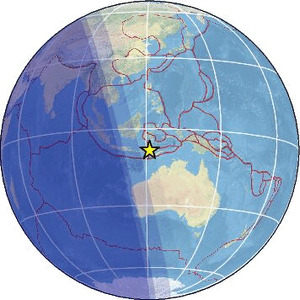
-
-
Part of Colombia's historic Manizales Cathedral comes crashing down as a powerful 7.4-magnitude earthquake rocks the country.
Debris spills into the streets of Manizales as the quake leaves widespread damage and injuries across several cities.
Emergency crews are now assessing the destruction while officials urge residents to stay alert for possible aftershocks.Video: https://t.me/ZetaTalk_Followers/92945
EARTHQUAKES Worldwide! (Frequently Updated) - Earth Changes and the...
-
-
A 7.4‑magnitude earthquake struck western Colombia on August 10, 2026, causing major destruction across multiple cities — including Manizales, which suffered structural damage and at least two confirmed deaths.
© 2026 Created by Juan F Martinez.
Powered by


You need to be a member of Earth Changes and the Pole Shift to add comments!
Join Earth Changes and the Pole Shift