EARTHQUAKES Worldwide! (Frequently Updated)
 Global Earthquake Maps
Regionally Specific Earthquake Maps
|
Related Informations:
Earthquakes during the poleshift Magnetic twist and the effects
|
Additional Information from the F.A.Q: Q: What is the "Earth Wobble"?
Q: How can I understand the Magnetosphere? - About the Magnetosphere
Q: Is there a relationship between disturbances in the magnetosphere and seismic activity? |
Altering Earthquakes:
As of late, I have observed that USGS and EMSC are a bit lax on their reports of earthquakes. Sometimes not seeing anything reported for hours from the last update, or seeing periods of 90-200 minutes with no earthquakes in between. My question is, are they leaving swarms of earthquakes out of their reports, or there are actually periods of no earthquakes?
SOZT: Greater than 90% of the earthquake activity is being altered by the USGS at present, which is under orders to prevent any clue being given to the public about the Earth changes caused by the presence of Planet X. Over a decade ago, the approach was to de-sensitize the live seismographs periodically, so the displays do not turn black worldwide, and to ignore the twice-a-day patterns showing up on these seismographs. Then any quakes that could be dropped were dropped. This was obvious to some who were watching the database manipulation. Quakes in the list would suddenly disappear. This was particularly the case where a quake happened in a remote location, or out in the ocean. Dumbing down the magnitude quickly followed, but in order to ensure the public did not notice, the USGS took control of all websites reporting quake statistics. At times, this control breaks, and discrepancies are reported to the public. Some countries rebel. Quake swarms are another source of control, as they pepper the databases with many quakes and skew the statistics, and thus are pulled from the database. Else the question is raised, why so many? EOZT
Will the USGS internet system be a reliable warning system for the European tsunami by registering on the net the New Madrid earthquake on the exact time it occurs?
SOZT: It will not be a lack of information from the USGS that will be the point of confusion during the earthquakes leading up to the New Madrid adjustment, it will be knowing which quake is the big one vs the many minor quakes preceding it. The USGS downgrades almost all earthquakes, to prevent meaningful statistics from being generated from their databases. They also exclude quakes whenever they can, but this is unlikely to happen in the New Madrid area as it is in the center of a populated land mass. Thus you will have magnitude 6 quakes that will be called a 5.2, magnitude 7 quakes called a 6.1, and when a magnitude 8 or greater quake occurs, it will be called a 6.9.
We would advise that rather than watching the USGS quake statistics, that you watch the Earth changes. The adjustment that will incite the European tsunami will involve bridges on the Mississippi breaking, and being impassable. The land to the west of the Mississippi will drop so that the Mississippi will become 50 miles wide in the state of Mississippi. Watch for this. The New Madrid adjustment will be several large quakes of magnitude 8-9, though will be listed as a lesser magnitude. As the N American continent continues to unzip up to and along the Seaway, the quakes will be less than a magnitude 8 but very destructive to Cleveland and Toledo and Buffalo and the inland locks along the Seaway. Thus it is not what the USGS says that should be watched, but the condition of the bridges on the Mississippi, the impact on the cities along the Seaway, and whether the inland locks are reported as inoperable. EOZT
Please collect earthquake-reports here. Significant Quakes or Magnitude 7+ can be posted separately.
[Edited by the Moderation]
Views: 578134
Comment
-
Comment by Tracie Crespo 19 hours ago
-
Magnitude 6.7 Region EASTERN NEW GUINEA REG., P.N.G. Date time 2025-10-07 11:05:19.5 UTC Location -6.688 ; 146.775 Depth 100 km Distance 313 km NNW of Port Moresby, Papua New Guinea / pop: 283,000 / local time: 21:05:19.5 2025-10-07
25 km W of Lae, Papua New Guinea / pop: 76,200 / local time: 21:05:19.5 2025-10-07Source parameters reviewed by a seismologist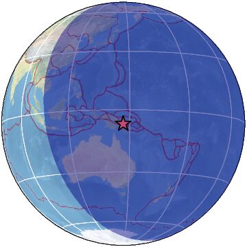
-
-
Magnitude 6.0 Region NEAR EAST COAST OF HONSHU, JAPAN Date time 2025-10-04 15:21:09.0 UTC Location 37.387 ; 141.653 Depth 47 km Distance 78 km NE of Iwaki, Japan / pop: 357,000 / local time: 00:21:09.0 2025-10-05
59 km E of Namie, Japan / pop: 21,800 / local time: 00:21:09.0 2025-10-05Source parameters provided by:
National Earthquake Information Center, U.S. Geological Survey -- Golden, United States (NEIC)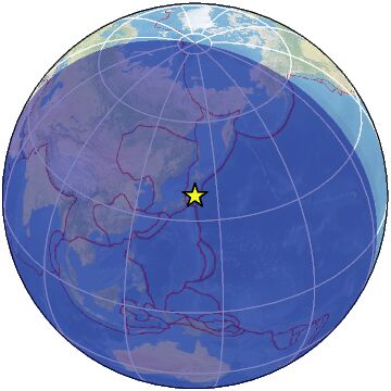
-
Comment by Juan F Martinez on Saturday
-
Strong mag. 5.5 Earthquake - Northern East Pacific Rise on Saturday, Oct 4, 2025, at 02:02 am (GMT -7)
-
-
5.1 quake Northern Mid-Atlantic Ridge Oct 3, 2025 04:17 am (Universal Time)
-
-
The moment of a 7.0 magnitude earthquake in the city of Cebu, Philippines. The settlement is located 95 kilometers from the epicenter. 30.09.25
Video: https://t.me/ZetaTalk_Followers/77308
-
Comment by jorge namour on September 30, 2025 at 4:37pm
-
M 6.9 - 11 km ESE of Calape, Philippines
2025-09-30 13:59:43 (UTC)11.151°N 124.138°E10.0 km depthhttps://earthquake.usgs.gov/earthquakes/eventpage/us6000rdrz/executive
------------------------------------------------------------------------5.5
92 km E of Petropavlovsk-Kamchatsky, Russia
2025-09-29 19:07:23 (UTC-03:00)
42.0 k
-
-
Magnitude 5.4 Region WESTERN TURKEY Date time 2025-09-28 09:59:16.8 UTC Location 39.323 ; 28.918 Depth 10 km Distance 84 km NW of Uşak, Turkey / pop: 152,000 / local time: 12:59:16.8 2025-09-28
27 km NNW of Simav, Turkey / pop: 34,900 / local time: 12:59:16.8 2025-09-28Source parameters reviewed by a seismologist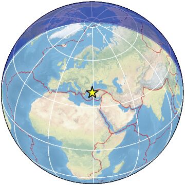 ------------------------------------------------------------------------------------------------------------------------------------------------------------
Magnitude 5.5 Region SOUTH OF FIJI ISLANDS Date time 2025-09-28 08:52:59.8 UTC Location -23.862 ; 178.842 Depth 556 km Distance 683 km SW of Nuku‘alofa, Tonga / pop: 22,400 / local time: 21:52:59.8 2025-09-28
637 km SSE of Suva, Fiji / pop: 77,300 / local time: 20:52:59.8 2025-09-28Source parameters provided by:
National Earthquake Information Center, U.S. Geological Survey -- Golden, United States (NEIC)
 -----------------------------------------------------------------------------------------------------------------------------------------------------------Turkey is on the move!
2025-09-28 12:15:15 13 min ago-6.730 106.590 13 2.5 JAVA, INDONESIA 2025-09-28 12:13:07 15 min ago19.189 -155.501 33 2.4 ISLAND OF HAWAII, HAWAII 2025-09-28 12:09:49 18 min ago39.240 29.005 10 2.9 WESTERN TURKEY 2025-09-28 11:59:30 28 min ago39.240 28.976 9 2.5 WESTERN TURKEY 2025-09-28 11:57:25 31 min ago39.280 28.918 6 1.7 WESTERN TURKEY 2025-09-28 11:54:59 33 min ago39.242 28.989 12 3.1 WESTERN TURKEY 2025-09-28 11:43:47 44 min ago39.189 28.941 6 1.3 WESTERN TURKEY 2025-09-28 11:40:55 47 min ago39.264 28.969 6 1.0 WESTERN TURKEY 2025-09-28 11:37:02 51 min ago39.221 29.006 10 1.4 WESTERN TURKEY 2025-09-28 11:35:37 52 min ago39.241 28.978 6 2.4 WESTERN TURKEY 2025-09-28 11:34:09 54 min ago39.253 28.880 10 1.5 WESTERN TURKEY 2025-09-28 11:31:47 56 min ago39.243 28.954 10 1.2 WESTERN TURKEY 2025-09-28 11:27:50 1 hr 00 min ago39.239 29.032 3 2.5 WESTERN TURKEY 2025-09-28 11:24:24 1 hr 04 min ago39.251 28.988 6 2.0 WESTERN TURKEY 2025-09-28 11:22:29 1 hr 05 min ago39.234 28.984 12 2.7 WESTERN TURKEY 2025-09-28 11:19:30 1 hr 08 min ago39.235 29.008 10 2.6 WESTERN TURKEY 2025-09-28 11:16:53 1 hr 11 min ago39.246 29.009 8 2.2 WESTERN TURKEY 2025-09-28 11:14:41 1 hr 13 min ago39.230 29.003 7 2.1 WESTERN TURKEY 2025-09-28 11:08:34 1 hr 19 min ago39.230 29.013 13 2.2 WESTERN TURKEY 2025-09-28 11:06:09 1 hr 22 min ago39.213 29.035 5 2.2 WESTERN TURKEY 2025-09-28 11:00:53 1 hr 27 min ago39.227 29.020 5 2.1 WESTERN TURKEY 2025-09-28 10:56:50 1 hr 31 min ago39.246 29.002 7 3.0 WESTERN TURKEY 2025-09-28 10:53:35 1 hr 34 min ago39.225 28.985 12 3.1 WESTERN TURKEY 2025-09-28 10:52:17 1 hr 36 min ago39.231 28.999 12 3.0 WESTERN TURKEY 2025-09-28 10:49:40 1 hr 38 min ago39.190 28.206 7 1.6 WESTERN TURKEY 2025-09-28 10:45:06 1 hr 43 min ago37.624 20.562 18 2.8 IONIAN SEA 2025-09-28 10:43:02 1 hr 45 min ago41.025 -5.456 0 2.0 SPAIN 2025-09-28 10:42:20 1 hr 46 min ago39.218 28.990 7 1.6 WESTERN TURKEY 2025-09-28 10:41:14 1 hr 47 min ago39.211 29.072 13 1.1 WESTERN TURKEY 3 2025-09-28 10:38:12 1 hr 50 min ago39.243 29.003 5 2.9 WESTERN TURKEY 2025-09-28 10:36:50 1 hr 51 min ago39.270 28.964 7 1.9 WESTERN TURKEY 1 2025-09-28 10:34:51 1 hr 53 min ago39.235 29.003 11 3.8 WESTERN TURKEY 2025-09-28 10:32:43 1 hr 55 min ago-5.520 104.500 10 2.9 SOUTHERN SUMATRA, INDONESIA 2025-09-28 10:30:55 1 hr 57 min ago39.244 28.986 7 1.8 WESTERN TURKEY 2025-09-28 10:28:52 1 hr 59 min ago39.244 28.969 5 3.3 WESTERN TURKEY 2025-09-28 10:28:09 2 hr 00 min ago-7.710 106.950 23 2.8 JAVA, INDONESIA 2025-09-28 10:25:11 2 hr 03 min ago39.218 29.039 10 2.2 WESTERN TURKEY 2025-09-28 10:23:58 2 hr 04 min ago39.215 29.001 15 2.2 WESTERN TURKEY 2025-09-28 10:23:41 2 hr 04 min ago38.292 38.176 7 1.2 EASTERN TURKEY 2025-09-28 10:22:23 2 hr 06 min ago39.223 29.019 10 2.8 WESTERN TURKEY 2025-09-28 10:20:24 2 hr 08 min ago39.149 -119.046 2 2.0 NEVADA 2025-09-28 10:20:21 2 hr 08 min ago39.221 28.988 11 2.7 WESTERN TURKEY 2025-09-28 10:14:15 2 hr 14 min ago39.207 29.002 10 2.7 WESTERN TURKEY 12 2025-09-28 10:12:59 2 hr 15 min ago39.246 28.997 6 3.0 WESTERN TURKEY 2025-09-28 10:11:29 2 hr 16 min ago28.833 -99.116 11 2.1 SOUTHERN TEXAS 2025-09-28 10:09:28 2 hr 18 min ago-8.720 117.340 143 2.5 SUMBAWA REGION, INDONESIA 2 2025-09-28 10:09:01 2 hr 19 min ago39.234 29.006 11 3.2 WESTERN TURKEY 2025-09-28 10:08:50 2 hr 19 min ago-7.490 105.970 13 3.5 JAVA, INDONESIA 2025-09-28 10:06:12 2 hr 22 min ago-19.915 -175.740 171 4.5 TONGA 73 2025-09-28 10:05:50 2 hr 22 min ago39.229 29.006 11 3.7 WESTERN TURKEY 6 2025-09-28 10:01:44 2 hr 26 min ago39.204 29.015 12 3.0 WESTERN TURKEY
-
-
Strong mag. 5.9 Earthquake - 231 km W of Bandon, Oregon, on Thursday, Sep 25, 2025, at 10:45 pm (GMT -8) - 10 hours ago
-
-
Magnitude 6.2 Region ZULIA, VENEZUELA Date time 2025-09-24 22:21:55.2 UTC Location 9.922 ; -70.717 Depth 8 km Distance 68 km NNW of Valera, Venezuela / pop: 244,000 / local time: 18:21:55.2 2025-09-24
24 km ENE of Mene Grande, Venezuela / pop: 60,500 / local time: 18:21:55.2 2025-09-24Source parameters provided by:
National Earthquake Information Center, U.S. Geological Survey -- Golden, United States (NEIC)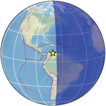
-
-
M 7.8 - 128 km E of Petropavlovsk-Kamchatsky, Russia
2025-09-18 18:58:12 (UTC)53.168°N 160.532°E10.0 km depth
https://earthquake.usgs.gov/earthquakes/eventpage/us7000qx2g/executive5.6
164 km ESE of Petropavlovsk-Kamchatsky, Russia
2025-09-18 17:03:02 (UTC-03:00)
10.0 km
4.7
150 km E of Petropavlovsk-Kamchatsky, Russia
2025-09-18 17:02:15 (UTC-03:00)
35.0 km
5.3
42 km WNW of Bacnotan, Philippines
2025-09-18 16:52:10 (UTC-03:00)
35.0 km
5.1
115 km ENE of Petropavlovsk-Kamchatsky, Russia
2025-09-18 16:38:02 (UTC-03:00)
52.9 km
5.6
163 km ESE of Petropavlovsk-Kamchatsky, Russia
2025-09-18 16:26:38 (UTC-03:00)
10.0 km
5.4
146 km E of Petropavlovsk-Kamchatsky, Russia
2025-09-18 16:19:24 (UTC-03:00)
32.8 km5.8
157 km E of Petropavlovsk-Kamchatsky, Russia
2025-09-18 16:08:20 (UTC-03:00)
10.0 k5.4
Scotia Sea
2025-09-18 16:07:47 (UTC-03:00)
10.0 km4.5
46 km SE of Hasaki, Japan
2025-09-18 15:39:19 (UTC-03:00)
25.1 km
6.1
28 km S of Nabire, Indonesia
2025-09-18 15:19:46 (UTC-03:00)
10.0
4.7
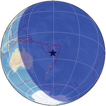
47 km W of Mendoza, Argentina
2025-09-18 15:03:21 (UTC-03:00)
124.4 km4.9
286 km E of Port Blair, India
2025-09-18 09:41:53 (UTC-03:00)
10.0 km4.9
Pacific-Antarctic Ridge
2025-09-18 05:19:01 (UTC-03:00)
10.0 km3.0
26 km S of Segundo, Colorado
2025-09-18 03:25:36 (UTC-03:00)
4.7 km4.5
65 km ESE of Kuqa, China
2025-09-17 21:13:43 (UTC-03:00)
10.0 km5.4
60 km SE of Petropavlovsk-Kamchatsky, Russia
2025-09-17 17:57:47 (UTC-03:00)
62.0 kmmagnitud 6.0
Países afectados: Islas Salomón y Papúa Nueva Guinea
A 147 km de Papúa Nueva Guinea · 16 sept, 1:59 p.m.magnitud 6.0
A 1433 km de Yuzhno-Sajalinsk, Rusia · 15 sept, 1:34 p.m.magnitud 5.5
Países afectados: India y Bután
A 12 km de Kharupatia, Assam, India · 14 sept, 8:11 a.
© 2025 Created by 0nin2migqvl32.
Powered by
![]()
You need to be a member of Earth Changes and the Pole Shift to add comments!
Join Earth Changes and the Pole Shift