EARTHQUAKES Worldwide! (Frequently Updated)

Global Earthquake Maps

ANF

EMSC

Global Incident Map

IRIS

SNNC

USGS

Regionally Specific Earthquake Maps

Australia

Canada

Germany

Japan

Iceland


Related Informations:


Earthquakes during the poleshift

Earth Wobble

Wobble effect

TT - Earth Wobble

Deep Quakes

Quake Swarms

Pre-Shift Quakes

Magnetic twist and the effects

Wobble sloshing

Scripted Drama

Quake charts


Additional Information from the F.A.Q:

Q: What is the "Earth Wobble"?
A: https://poleshift.ning.com/forum/topics/explaining-the-earth-wobble


Q: How can I understand the Magnetosphere?

- About the Magnetosphere
- What the graphs on the Magnetosphere Simulation mean


Q: Is there a relationship between disturbances in the magnetosphere and seismic activity?
- Magnetosphere Deformations and Earth Wobble Effects
- Approach to Earthquake Prediction from the Magnetosphere Simulation
- Analysis try; Earthquakes/plate movement and magnetosphere simula...

Altering Earthquakes:

ZetaTalk Aug 7, 2010

As of late, I have observed that USGS and EMSC are a bit lax on their reports of earthquakes. Sometimes not seeing anything reported for hours from the last update, or seeing periods of 90-200 minutes with no earthquakes in between. My question is, are they leaving swarms of earthquakes out of their reports, or there are actually periods of no earthquakes?

SOZT:   Greater than 90% of the earthquake activity is being altered by the USGS at present, which is under orders to prevent any clue being given to the public about the Earth changes caused by the presence of Planet X. Over a decade ago, the approach was to de-sensitize the live seismographs periodically, so the displays do not turn black worldwide, and to ignore the twice-a-day patterns showing up on these seismographs. Then any quakes that could be dropped were dropped. This was obvious to some who were watching the database manipulation. Quakes in the list would suddenly disappear. This was particularly the case where a quake happened in a remote location, or out in the ocean. Dumbing down the magnitude quickly followed, but in order to ensure the public did not notice, the USGS took control of all websites reporting quake statistics. At times, this control breaks, and discrepancies are reported to the public. Some countries rebel. Quake swarms are another source of control, as they pepper the databases with many quakes and skew the statistics, and thus are pulled from the database. Else the question is raised, why so many?   EOZT


ZetaTalk Jun 18, 2011

Will the USGS internet system be a reliable warning system for the European tsunami by registering on the net the New Madrid earthquake on the exact time it occurs?

SOZT:   It will not be a lack of information from the USGS that will be the point of confusion during the earthquakes leading up to the New Madrid adjustment, it will be knowing which quake is the big one vs the many minor quakes preceding it. The USGS downgrades almost all earthquakes, to prevent meaningful statistics from being generated from their databases. They also exclude quakes whenever they can, but this is unlikely to happen in the New Madrid area as it is in the center of a populated land mass. Thus you will have magnitude 6 quakes that will be called a 5.2, magnitude 7 quakes called a 6.1, and when a magnitude 8 or greater quake occurs, it will be called a 6.9.

We would advise that rather than watching the USGS quake statistics, that you watch the Earth changes. The adjustment that will incite the European tsunami will involve bridges on the Mississippi breaking, and being impassable. The land to the west of the Mississippi will drop so that the Mississippi will become 50 miles wide in the state of Mississippi. Watch for this. The New Madrid adjustment will be several large quakes of magnitude 8-9, though will be listed as a lesser magnitude. As the N American continent continues to unzip up to and along the Seaway, the quakes will be less than a magnitude 8 but very destructive to Cleveland and Toledo and Buffalo and the inland locks along the Seaway. Thus it is not what the USGS says that should be watched, but the condition of the bridges on the Mississippi, the impact on the cities along the Seaway, and whether the inland locks are reported as inoperable.   EOZT


Please collect earthquake-reports here. Significant Quakes or Magnitude 7+ can be posted separately.

[Edited by the Moderation]


Views: 576688

Comment

You need to be a member of Earth Changes and the Pole Shift to add comments!

Join Earth Changes and the Pole Shift

Comment by Tracie Crespo yesterday

https://www.nbcnews.com/world/asia/least-250-killed-6-magnitude-ear...


At least 800 killed as 6.0-magnitude earthquake rocks Afghanistan

Officials said hundreds of other people were injured in the quake, which struck outside the eastern city of Jalalabad near the border with Pakistan.


PESHAWAR, Pakistan — At least 800 people have been killed and more than 1,300 others injured in Afghanistan after a 6.0-magnitude earthquake hit the country, Taliban officials said Monday.

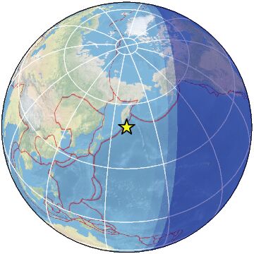
The earthquake struck 17 miles from the eastern city of Jalalabad, near the border with Pakistan, at aound midnight local time (3:30 p.m. ET Sunday), according to the U.S. Geological Survey.

Because the earthquake hit a remote mountainous area, “it will take time to get the exact information about human losses and damage to the infrastructure,” said Sharafat Zaman, a spokesperson for the Afghan Public Health Ministry.

“We have launched a massive rescue operation and mobilized hundreds of people to help people in the affected areas,” Zaman said.

AFGHANISTAN-EARTHQUAKE
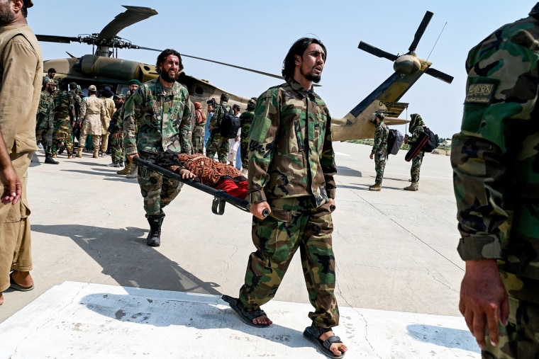
Taliban security personnel carry an earthquake victim evacuated by a military helicopter from the Nurgal district of Kunar province, in Jalalabad on Monday.Wakil Kohsar / AFP via Getty Images

Taliban spokesperson Zabihullah Mujahid said the death toll had risen to 800 people. Earlier, Afghan interior ministry spokesperson Mufti Abdul Matin Qani had said 622 people had been confirmed dead and more than 1,300 injured in the eastern provinces of Nangarhar, which includes Jalalabad, and Kunar.

The ministry said that 1,000 injured people had been evacuated and admitted to hospitals.

A U.N. team has been mobilized in Afghanistan, Secretary-General António Guterres said in a post on X. Several U.N. organizations, including the Children's Fund, the World Health Organization, Office for the Coordination of Humanitarian Affairs, and the International Organization for Migration, said on X that they were providing emergency assistance.

Image: TOPSHOT-AFGHANISTAN-EARTHQUAKE
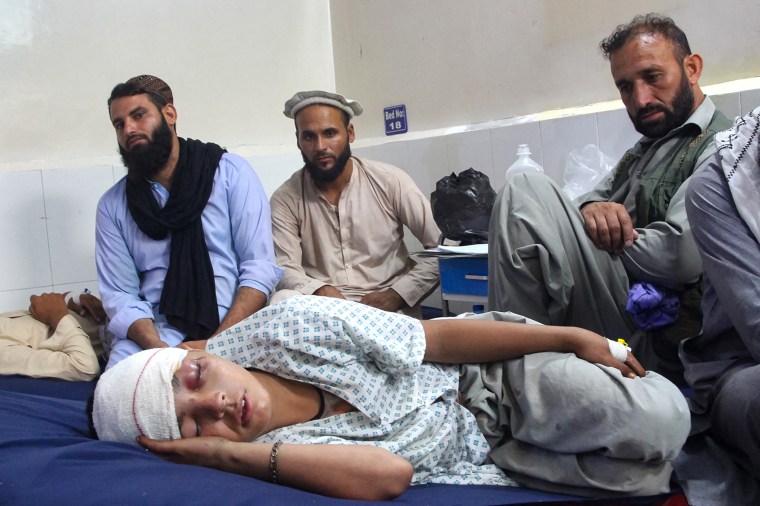
An injured Afghan boy being treated at a hospital in Jalalabad after the earthquake on Monday. AIMAL ZAHIR / AFP - Getty Images

Construction quality is poor in rural Afghanistan, where buildings are often made of mud bricks and wood. Videos from Kunar showed collapsed homes and rescuers combing through the rubble for survivors. Injured people from these remote areas were seen being lifted on gurneys onto helicopters.

'I was half buried'

Victims watched as their homes collapsed before their eyes at night. One survivor, Sadiqullah, said, "I was half buried and unable to get out."

Sadiqullah, who like other Afghans uses only one name, was awakened by what he described as a loud boom sound and rushed to grab his family, who were sleeping.

He was able to rescue three of his children but before he could rescue the rest of his family, the roof fell on top of him.

"My wife and two sons are dead and my father is injured and in hospital with me," he told the Associated Press. "We were trapped for three to four hours until people from other areas arrived and pulled me out.”

Since the initial quake, at least five aftershocks ranging from 4.5 magnitude to 5.2 magnitude have hit the area throughout Monday, according to the USGS.

Civil defense workers, locals, and army soldiers prepare to evacuate injured victims of an earthquake
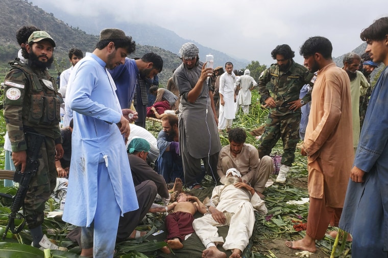
Civil defense workers, locals, and army soldiers prepare to evacuate injured victims in Mazar Dara, Kunar province, on Monday.Hedayat Shah / AP

Aftershocks can last for days and can sometimes be worse than the first quake.

Afghanistan is especially vulnerable to earthquakes as it sits on top of several fault lines where the Indian and Eurasian plates meet. The mountainous terrain of eastern Afghanistan is also prone to landslides, making it harder for emergency services to carry out rescues.

This quake was especially devastating as it hit at a shallow depth of 5 miles, making it far more destructive even at moderate magnitude.

People carry an earthquake victim on a stretcher to an ambulance at an airport in Jalalabad
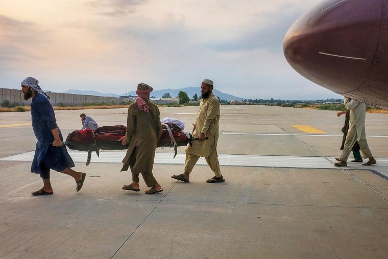
People carrying an earthquake victim to an ambulance at an airport in Jalalabad on Monday.Reuters

In 2022, around 1,000 people were killed and thousands more were injured when a 5.9-magnitude earthquake hit eastern Afghanistan.

That, too, was a shallow quake.

The next year, three 6.3-magnitude quakes hit the western Afghanistan province of Herat in one week. The Taliban said around 4,000 people were killed, though the United Nations put the death tally at 1,500.

Monday's quake comes at a challenging time for Afghanistan, one of the world’s poorest countries, which is suffering from four consecutive years of drought and the influx of over 2.3 million Afghans who have returned from Iran and Pakistan this year.

“Below-average first and second season crop production and reduced livestock income limit their ability to stock food for the winter,” the Famine Early Warning Systems Network, which was established by the United States Agency for International Development, said in a report last week.

Afghanistan’s humanitarian crisis has been fueled by decades of conflict, including the 20-year U.S. war with the Taliban. Aid agencies say roughly 23 million people — half of the country’s population — need aid.

Until last year, the U.S. provided nearly half of all humanitarian aid to Afghanistan. But under President Donald Trump, the U.S. has cancelled an estimated $1.7 billion of that support, according to a report filed to Congress in April by the Special Inspector General for Afghanistan Reconstruction.

The administration has also refused to restore its emergency food aid for Afghanistan, while restoring it for some other countries.

Mushtaq Yusufzai reported from Peshawar and Mithil Aggarwal from Hong Kong.

Comment by jorge namour on Wednesday

M 5.4 - 17 km E of Novokayakent, Russia
2025-08-26 20:33:30 (UTC)42.365°N 48.198°E10.0 km depth
https://earthquake.usgs.gov/earthquakes/eventpage/us7000qr6h/executive
.....................................................

5.0
western Xizang

2025-08-26 17:16:09 (UTC-03:00)
10.0 km

5.2
Drake Passage

2025-08-26 21:04:37 (UTC-03:00)
10.0 km

6.0
98 km E of Severo-Kuril’sk, Russia

2025-08-27 00:49:51 (UTC-03:00)
53.4 km

4.3
11 km SSE of Sındırgı, Turkey
2025-08-26 23:46:20 (UTC-03:00)
10.0 km

5.1
South Sandwich Islands region
2025-08-27 02:34:06 (UTC-03:00)
31.2 km

5.1
35 km SW of Ashkāsham, Afghanistan
2025-08-27 10:27:10 (UTC-03:00)
128.3 km
5.3
17 km ENE of Yilan, Taiwan
2025-08-27 10:10:59 (UTC-03:00)
116.0 km

5.2
Carlsberg Ridge
2025-08-27 07:19:59 (UTC-03:00)
10.0 km
,,,,,,,,,,,,,,,,,,,,,,,,,,,,,,,,,,,,,,,,,,,,,,,,,,,,,,,,,

AUSTRALIA REGION

FROM LINK

Magnitude 2 and above around AU
26th August 2024 to 26th August 2025

Comment by Tracie Crespo on August 25, 2025 at 1:11pm

Was a 6.7 not long ago...

https://www.emsc-csem.org/Earthquake_information/earthquake.php?id=...

Magnitude 6.2
Region EAST OF KURIL ISLANDS
Date time 2025-08-25 06:48:35.5 UTC
Location 49.418 ; 160.071
Depth 12 km
Distance 418 km SSE of Petropavlovsk-Kamchatsky, Russia / pop: 187,000 / local time: 18:48:35.5 2025-08-25
314 km ESE of Severo-Kuril’sk, Russia / pop: 2,400 / local time: 17:48:35.5 2025-08-25
Source parameters reviewed by a seismologist


Global view
May be an image of map and text that says '09:03 Earthquakes Tracker Free @Event Time 6.7 mb-East mb- Of Kuril Islands 14 minutes ago, 8:48 A uth KoreaJapan Japan Korea Papua New Guinea Googl CP Center Parcs 이기기 eHuttenh... DeHuttenh..Het.Meerdal Het Meerdal'
Comment by Tracie Crespo on August 23, 2025 at 2:26pm

https://www.emsc-csem.org/Earthquake_information/earthquake.php?id=...

Magnitude 6.0
Region OFFSHORE EL SALVADOR
Date time 2025-08-23 09:14:21.4 UTC
Location 13.075 ; -90.361
Depth 10 km
Distance 134 km SSW of Santa Ana, El Salvador / pop: 176,000 / local time: 03:14:21.4 2025-08-23
81 km SW of Acajutla, El Salvador / pop: 22,700 / local time: 03:14:21.4 2025-08-23
Source parameters provided by:

National Earthquake Information Center, U.S. Geological Survey -- Golden, United States (NEIC)


Global view
Comment by Juan F Martinez on August 22, 2025 at 6:17am

Here we go again, @ShadowofEzra blaming manmade causes for Nibiru Effects!

HAARP is Establishment Disinformation to hide the truth about Nibiru and the pending Pole Shift.

https://x.com/ZT_Followers/status/1958737727765323938

ZetaTalk: HAARP
https://zetatalk.com/govmt/g35.htm

The Worst of the Cover-Up - Earth Changes and the Pole Shift
https://poleshift.ning.com/profiles/blogs/the-worst-of-the-cover-up

Main Establishment Lies (NEW ZetaTalk) - Earth Changes and the Pole Shift
https://poleshift.ning.com/profiles/blogs/main-establishment-lies

Comment by Tracie Crespo on August 22, 2025 at 4:58am

Already downgraded, was an 8 a few minutes ago...

Magnitude 7.5
Region DRAKE PASSAGE
Date time 2025-08-22 02:16:20.1 UTC
Location -60.207 ; -61.720
Depth 10 km
Distance 962 km SE of Punta Arenas, Chile / pop: 117,000 / local time: 23:16:20.1 2025-08-21
717 km SE of Ushuaia, Argentina / pop: 58,000 / local time: 23:16:20.1 2025-08-21
Source parameters reviewed by a seismologist


Global view
Comment by jorge namour on August 14, 2025 at 8:34pm

MAY BE RELATED TO WESTERN TURKRY 6.1 QUAKE FELT IN ISTANBUL

https://www.facebook.com/photo/?fbid=1095354139405170&set=a.594...

Turkey Urgent

·#Urgent: The Istanbul Strait has been closed to shipping traffic.

Comment by jorge namour on August 14, 2025 at 7:57pm

6.2
111 km SSE of Lata, Solomon Islands

2025-08-14 13:22:35 (UTC-03:00)
52.7 km

magnitud 5.6
A 157 km de Neiafu, Tonga ·
1:38 a.m.

magnitud 5.4
País afectado: Indonesia
A 194 km de Dili, Timor Oriental
· 12 ago, 1:21 p.m.

magnitud 6.3
Países afectados: Indonesia y Papúa Nueva Guinea

A 31 km de Sarmi, Papúa, Indonesia · 12 ago, 5:24 a.m.

magnitud 5.9
A 99 km de Dededo, Guam · 10 ago, 1:56 a.m.

magnitud 5.9
Países afectados: El Salvador, Guatemala y México

A 102 km de Champerico, Guatemala · 9 ago, 5:40 p.m.

magnitud 6.0
A 1298 km de Yuzhno-Sajalinsk, Rusia
· 9 ago, 11:04 a.m.
------------------------------------------------------

5.0
104 km S of Severo-Kuril’sk, Russia
2025-08-14 13:46:56 (UTC-03:00)
54.4 km

4.2
37 km ESE of Lazi, Philippines
2025-08-14 05:34:03 (UTC-03:00)
541.7 km
4.3
29 km ENE of Biratori, Japan
2025-08-14 04:31:34 (UTC-03:00)
128.1 km

4.5
80 km ESE of Ozernovskiy, Russia
2025-08-14 04:19:36 (UTC-03:00)
69.4 km

4.6
164 km ESE of Severo-Kuril’sk, Russia
2025-08-13 20:42:36 (UTC-03:00)
19.4 km

3.2
26 km W of Hebgen Lake Estates, Montana

2025-08-13 20:23:10 (UTC-03:00)
12.5 km

4.6
165 km ESE of Severo-Kuril’sk, Russia
2025-08-13 20:11:55 (UTC-03:00)
10.0 km

4.6
77 km SE of Ozernovskiy, Russia
2025-08-13 18:31:36 (UTC-03:00)

72.3 km
4.3
4 km WNW of Rudna, Poland
2025-08-13 18:30:07 (UTC-03:00)
13.3 km
4.3
119 km ESE of Ozernovskiy, Russia
2025-08-13 17:28:43 (UTC-03:00)
43.4 km
4.9
36 km ESE of Hitachi, Japan
2025-08-13 16:13:39 (UTC-03:00)
59.6 km
4.0
northwest of the Kuril Islands
2025-08-13 15:20:30 (UTC-03:00)
306.8 km

Comment by Tracie Crespo on August 10, 2025 at 8:34pm
Magnitude 6.1
Region WESTERN TURKEY
Date time 2025-08-10 16:53:47.8 UTC
Location 39.278 ; 28.068
Depth 10 km
Distance 44 km SSE of Balıkesir, Turkey / pop: 238,000 / local time: 19:53:47.8 2025-08-10
14 km SSW of Bigadiç, Turkey / pop: 15,200 / local time: 19:53:47.8 2025-08-10
Source parameters reviewed by a seismologist


Global view
Comment by James of Idaho on August 10, 2025 at 8:16pm

August 6th, 2025   Quake clouds emanating from the Missouri River  upper Nebraska region.....Video link Below
https://www.facebook.com/share/v/17APBDDyAY/    Source link-GOES Imagery Viewer - NOAA / NESDIS / STAR

SEARCH PS Ning or Zetatalk

 
Search:

This free script provided by
JavaScript Kit

Donate

Donate to support Pole Shift ning costs. Thank you!

© 2025   Created by 0nin2migqvl32.   Powered by

Badges  |  Report an Issue  |  Terms of Service