EARTHQUAKES Worldwide! (Frequently Updated)
 Global Earthquake Maps
Regionally Specific Earthquake Maps
|
Related Informations:
Earthquakes during the poleshift Magnetic twist and the effects
|
Additional Information from the F.A.Q: Q: What is the "Earth Wobble"?
Q: How can I understand the Magnetosphere? - About the Magnetosphere
Q: Is there a relationship between disturbances in the magnetosphere and seismic activity? |
Altering Earthquakes:
As of late, I have observed that USGS and EMSC are a bit lax on their reports of earthquakes. Sometimes not seeing anything reported for hours from the last update, or seeing periods of 90-200 minutes with no earthquakes in between. My question is, are they leaving swarms of earthquakes out of their reports, or there are actually periods of no earthquakes?
SOZT: Greater than 90% of the earthquake activity is being altered by the USGS at present, which is under orders to prevent any clue being given to the public about the Earth changes caused by the presence of Planet X. Over a decade ago, the approach was to de-sensitize the live seismographs periodically, so the displays do not turn black worldwide, and to ignore the twice-a-day patterns showing up on these seismographs. Then any quakes that could be dropped were dropped. This was obvious to some who were watching the database manipulation. Quakes in the list would suddenly disappear. This was particularly the case where a quake happened in a remote location, or out in the ocean. Dumbing down the magnitude quickly followed, but in order to ensure the public did not notice, the USGS took control of all websites reporting quake statistics. At times, this control breaks, and discrepancies are reported to the public. Some countries rebel. Quake swarms are another source of control, as they pepper the databases with many quakes and skew the statistics, and thus are pulled from the database. Else the question is raised, why so many? EOZT
Will the USGS internet system be a reliable warning system for the European tsunami by registering on the net the New Madrid earthquake on the exact time it occurs?
SOZT: It will not be a lack of information from the USGS that will be the point of confusion during the earthquakes leading up to the New Madrid adjustment, it will be knowing which quake is the big one vs the many minor quakes preceding it. The USGS downgrades almost all earthquakes, to prevent meaningful statistics from being generated from their databases. They also exclude quakes whenever they can, but this is unlikely to happen in the New Madrid area as it is in the center of a populated land mass. Thus you will have magnitude 6 quakes that will be called a 5.2, magnitude 7 quakes called a 6.1, and when a magnitude 8 or greater quake occurs, it will be called a 6.9.
We would advise that rather than watching the USGS quake statistics, that you watch the Earth changes. The adjustment that will incite the European tsunami will involve bridges on the Mississippi breaking, and being impassable. The land to the west of the Mississippi will drop so that the Mississippi will become 50 miles wide in the state of Mississippi. Watch for this. The New Madrid adjustment will be several large quakes of magnitude 8-9, though will be listed as a lesser magnitude. As the N American continent continues to unzip up to and along the Seaway, the quakes will be less than a magnitude 8 but very destructive to Cleveland and Toledo and Buffalo and the inland locks along the Seaway. Thus it is not what the USGS says that should be watched, but the condition of the bridges on the Mississippi, the impact on the cities along the Seaway, and whether the inland locks are reported as inoperable. EOZT
Please collect earthquake-reports here. Significant Quakes or Magnitude 7+ can be posted separately.
[Edited by the Moderation]
Views: 574650
Comment
-
Comment by jorge namour 9 hours ago
-
M 8.7 - 126 km ESE of Petropavlovsk-Kamchatsky, Russia
2025-07-29 23:24:50 (UTC)52.510°N 160.261°E18.2 km depth
https://earthquake.usgs.gov/earthquakes/eventpage/us6000qw60/executive5.6
181 km SSE of Severo-Kuril’sk, Russia
2025-07-29 21:55:50 (UTC-03:00)
10.0 km
5.7
136 km SSE of Vilyuchinsk, Russia
2025-07-29 21:35:22 (UTC-03:00)
10.0 km
5.4
110 km SE of Petropavlovsk-Kamchatsky, Russia
2025-07-29 21:31:13 (UTC-03:00)
10.0 km
6.3
131 km SE of Vilyuchinsk, Russia
2025-07-29 21:16:03 (UTC-03:00)
10.0 km
6.9
147 km SE of Petropavlovsk-Kamchatsky, Russia
2025-07-29 21:09:53 (UTC-03:00)
10.0 km
-
-
FROM LINK
🚨HEADS UP UPGRADED: 8.7 EARTHQUAKE — Just Confirmed
The massive quake that struck off the east coast of Kamchatka, Russia has now been upgraded to a magnitude 8.7 by the USGS. This is one of the strongest quakes we’ve seen this year — and a Tsunami Watch remains in effect for the region.
📍 Location: Offshore Kamchatka
💥 Magnitude: 8.7
📏 Depth: 11 miles
🕓 Time: 4:24 PM local — July 29, 2025
🌊 Tsunami Watch active
This is unfolding in real-time — and we’re keeping a close eye on seismic and oceanic data. Kamchatka is highly volcanic, and this kind of energy release could trigger more movement.
Stay safe. Stay aware.
-
-
M 8.0 - 136 km ESE of Petropavlovsk-Kamchatsky, Russia
2025-07-29 23:24:50 (UTC)52.473°N 160.396°E19.3 km depth
https://earthquake.usgs.gov/earthquakes/eventpage/us6000qw60/executiveM 6.6 - south of the Fiji Islands
2025-07-29 17:53:41 (UTC)23.352°S 178.824°E553.0 km depth
https://earthquake.usgs.gov/earthquakes/eventpage/us6000qw1a/executive
...................................................4.5
74 km WNW of Ferndale, CA
2025-07-29 20:18:18 (UTC-03:00)
10.5 km
5.4
0 km W of Zapotitlán, Guatemala
2025-07-29 20:05:21 (UTC-03:00)
10.0 km
4.2
Izu Islands, Japan region
2025-07-29 19:50:08 (UTC-03:00)
441.1 km
4.8
3 km S of Comapa, Guatemala
2025-07-29 18:42:27 (UTC-03:00)
10.0 km6 km W of El Adelanto, Guatemala
2025-07-29 18:25:24 (UTC-03:00)
10.0 km
5.6
3 km WNW of Jerez, Guatemala
2025-07-29 18:21:48 (UTC-03:00)
7.7 k
-
Comment by Tracie Crespo yesterday
-
Magnitude 6.9 Region MACQUARIE ISLAND REGION Date time 2025-07-28 22:10:33.7 UTC Location -57.738 ; 157.219 Depth 10 km Distance 1598 km SSW of Dunedin, New Zealand / pop: 114,000 / local time: 10:10:33.7 2025-07-29
1448 km SSW of Bluff, New Zealand / pop: 1,900 / local time: 10:10:33.7 2025-07-29Source parameters reviewed by a seismologist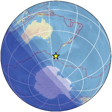
-
-
M 6.5 - 258 km WNW of Sabang, Indonesia
2025-07-28 18:41:48 (UTC)6.700°N 93.123°E10.0 km depth
https://earthquake.usgs.gov/earthquakes/eventpage/us6000qvpp/executive----------------------------------------------------
5.0
84 km SSW of Masachapa, Nicaragua
2025-07-28 17:55:20 (UTC-03:00)
10.0 km5.1
29 km NW of Rumonge, Burundi
2025-07-28 10:38:20 (UTC-03:00)
10.0 km5.1
138 km ESE of Petropavlovsk-Kamchatsky, Russia
2025-07-28 08:45:03 (UTC-03:00)
10.0 km
4.4
36 km WSW of Mohr, Iran
2025-07-28 08:24:19 (UTC-03:00)
10.0 km
4.6
south of the Fiji Islands
2025-07-28 08:22:37 (UTC-03:00)
130.3 k4.6
12 km NNW of Arta, Djibouti
2025-07-28 02:30:50 (UTC-03:00)
10.0 km
4.5
26 km WSW of Mohr, Iran
2025-07-28 02:19:53 (UTC-03:00)
10.0 km4.8
60 km SE of Hicks Bay, New Zealand
2025-07-27 22:07:40 (UTC-03:00)
14.7 km5.1
101 km WNW of Höfn, Iceland
2025-07-27 20:40:02 (UTC-03:00)
10.0 km
5.3
21 km N of Dutch Harbor, Alaska
2025-07-27 19:47:05 (UTC-03:00)
83.0 km
-
-
M 6.6 - 176 km SSE of Mata-Utu, Wallis and Futuna
2025-07-24 23:37:56 (UTC)14.815°S 175.720°W314.2 km depth
................................................................4.9
171 km E of Petropavlovsk-Kamchatsky, Russia
2025-07-24 20:27:39 (UTC-03:00)
10.0 km
5.8
157 km E of Petropavlovsk-Kamchatsky, Russia
2025-07-24 19:39:24 (UTC-03:00)
10.0 km6.1
167 km E of Petropavlovsk-Kamchatsky, Russia
2025-07-24 19:37:25 (UTC-03:00)
10.0 km5.4
Pagan region, Northern Mariana Islands
2025-07-24 16:22:39 (UTC-03:00)
143.0 km
4.6
139 km ESE of Petropavlovsk-Kamchatsky, Russia
2025-07-24 16:09:42 (UTC-03:00)
10.05.7
53 km WSW of Angoram, Papua New Guinea
2025-07-24 13:37:19 (UTC-03:00)
115.5 km4.7
south of the Fiji Islands
2025-07-24 11:55:30 (UTC-03:00)
230.0 km
4.7
west of Macquarie Island
2025-07-24 11:30:29 (UTC-03:00)
10.0 km5.6
66 km S of Poso, Indonesia
2025-07-24 10:08:19 (UTC-03:00)
34.7 km5.5
68 km NE of Masamba, Indonesia
2025-07-24 10:07:02 (UTC-03:00)
42.6 km4.9
Scotia Sea
2025-07-24 09:02:48 (UTC-03:00)
10.0 km
4.7
144 km SE of Petropavlovsk-Kamchatsky, Russia
2025-07-24 08:39:19 (UTC-03:00)
10.0 km5.2
29 km NNE of Calama, Chile
2025-07-23 21:46:20 (UTC-03:00)
111.5 kmmagnitud 6.3
Países afectados: Indonesia, Filipinas y Malasia
A 109 km de Gorontalo Regency, Gorontalo, Indonesia · 23 jul, 5:50 p.m.magnitud 6.1
A 1421 km de Yuzhno-Sajalinsk, Rusia · 21 jul, 10:59 p.m.magnitud 6.2
A 444 km de Unalaska, Alaska, EE. UU. · 20 jul, 7:28 p.m.
-
-
Magnitude 6.3 Region MINAHASA, SULAWESI, INDONESIA Date time 2025-07-23 20:50:44.1 UTC Location 0.426 ; 122.054 Depth 140 km Distance 285 km NE of Palu, Indonesia / pop: 282,000 / local time: 04:50:44.1 2025-07-24
113 km WSW of Gorontalo, Indonesia / pop: 144,000 / local time: 04:50:44.1 2025-07-24Source parameters provided by:
GeoForschungsZentrum (GFZ) -- Potsdam, Germany (GFZ)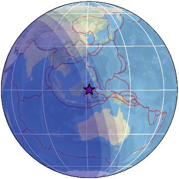 ----------------------------------------------------------------------------------------------------------------------------------------------------------
Magnitude 5.1 Region CRETE, GREECE Date time 2025-07-23 13:26:52.4 UTC Location 35.815 ; 23.464 Depth 50 km Distance 161 km W of Irákleion, Greece / pop: 137,000 / local time: 16:26:52.4 2025-07-23
40 km NW of Kíssamos, Greece / pop: 4,200 / local time: 16:26:52.4 2025-07-23Source parameters reviewed by a seismologist
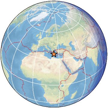 --------------------------------------------------------------------------------------------------------------------------------------------------------
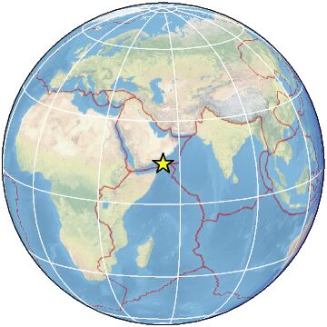
Magnitude 5.3 Region OWEN FRACTURE ZONE REGION Date time 2025-07-23 10:02:23.6 UTC Location 14.595 ; 53.776 Depth 10 km Distance 271 km S of Şalālah, Oman / pop: 163,000 / local time: 14:02:23.6 2025-07-23
218 km NNW of Hadibu, Yemen / pop: 8,500 / local time: 13:02:23.6 2025-07-23Source parameters reviewed by a seismologist
-
-
M 7.4 - 2025 Eastern Kamchatka, Russia Earthquake
2025-07-20 06:49:02 (UTC)52.899°N 160.759°E20.0 km depth
https://earthquake.usgs.gov/earthquakes/eventpage/us7000qdyl/executive4.7
151 km ESE of Petropavlovsk-Kamchatsky, Russia
2025-07-20 05:01:31 (UTC-03:00)
10.0 km
5.0
152 km E of Petropavlovsk-Kamchatsky, Russia
2025-07-20 04:53:24 (UTC-03:00)
10.0 km
4.6
144 km ESE of Petropavlovsk-Kamchatsky, Russia
2025-07-20 04:42:13 (UTC-03:00)
10.0 km
4.8
143 km E of Petropavlovsk-Kamchatsky, Russia
2025-07-20 04:36:27 (UTC-03:00)
10.0 km
6.0
166 km E of Petropavlovsk-Kamchatsky, Russia
2025-07-20 04:26:17 (UTC-03:00)
10.0 km
6.6
147 km E of Petropavlovsk-Kamchatsky, Russia
2025-07-20 04:22:58 (UTC-03:00)
9.4 km
5.3
150 km ESE of Petropavlovsk-Kamchatsky, Russia
2025-07-20 04:18:54 (UTC-03:00)
10.0 km
5.7
156 km ESE of Petropavlovsk-Kamchatsky, Russia
2025-07-20 04:12:58 (UTC-03:00)
10.0 km
5.6
157 km ESE of Petropavlovsk-Kamchatsky, Russia
2025-07-20 04:09:45 (UTC-03:00)
10.0 km
6.7
151 km E of Petropavlovsk-Kamchatsky, Russia
2025-07-20 04:07:43 (UTC-03:00)
8.7 km
5.2
141 km ESE of Petropavlovsk-Kamchatsky, Russia
2025-07-20 04:06:22 (UTC-03:00)
10.0 km
5.2
147 km E of Petropavlovsk-Kamchatsky, Russia
2025-07-20 04:02:09 (UTC-03:00)
10.0 km
2.7
16 km SW of Susitna, Alaska
2025-07-20 03:49:37 (UTC-03:00)
54.3 km
7.4
2025 Eastern Kamchatka, Russia Earthquake
2025-07-20 03:49:02 (UTC-03:00)
20.0 km
4.7
138 km ESE of Petropavlovsk-Kamchatsky, Russia
2025-07-20 03:44:37 (UTC-03:00)
10.0 km
4.6
143 km E of Petropavlovsk-Kamchatsky, Russia
2025-07-20 03:39:20 (UTC-03:00)
10.0 km
4.7
160 km ESE of Petropavlovsk-Kamchatsky, Russia
2025-07-20 03:37:28 (UTC-03:00)
10.0 km
2.7
17 km WSW of Johannesburg, CA
2025-07-20 03:32:46 (UTC-03:00)
6.9 km
5.2
152 km E of Petropavlovsk-Kamchatsky, Russia
2025-07-20 03:31:28 (UTC-03:00)
10.0 km
6.7
130 km E of Petropavlovsk-Kamchatsky, Russia
2025-07-20 03:28:16 (UTC-03:00)
15.0 km
................................................................5.0
132 km E of Petropavlovsk-Kamchatsky, Russia
2025-07-20 03:02:53 (UTC-03:00)
33.0 k5.5
98 km SSW of Basco, Philippines
2025-07-20 02:45:32 (UTC-03:00)
39.7 km4.4
83 km SSW of Puerto San José, Guatemala
2025-07-20 02:14:02 (UTC-03:00)
35.0 km4.7
78 km SSE of Sand Point, Alaska
2025-07-20 00:58:51 (UTC-03:00)
43.2 k4.5
central Mid-Atlantic Ridge
2025-07-20 00:35:32 (UTC-03:00)
10.0 km4.5
227 km WSW of Puerto Chacabuco, Chile
2025-07-19 23:43:12 (UTC-03:00)
10.0 k4.2
78 km SW of Puerto Madero, Mexico
2025-07-19 23:14:58 (UTC-03:00)
35.0 km
4.5
48 km NE of Tatsugō, Japan
2025-07-19 22:34:13 (UTC-03:00)
10.0 km
4.7
120 km E of Barcelona, Philippines
2025-07-19 21:29:16 (UTC-03:00)
10.0 km5.4
31 km E of Qarnābād, Iran
2025-07-19 18:37:47 (UTC-03:00)
10.0 km
5.2
northern East Pacific Rise
2025-07-19 18:26:39 (UTC-03:00)
10.0 km5.4
140 km E of Barcelona, Philippines
2025-07-19 13:25:20 (UTC-03:00)
10.0 km114 km S of Sand Point, Alaska
2025-07-19 13:20:58 (UTC-03:00)
42.6 km
5.6
northern East Pacific Rise
2025-07-19 12:55:08 (UTC-03:00)
10.0 km
5.4
northern East Pacific Rise
2025-07-19 12:28:44 (UTC-03:00)
10.0 km
4.5
146 km SSW of Manuel Ávila Camacho (Ponte Duro), Mexico
2025-07-19 11:41:04 (UTC-03:00)
10.0 km4.5
258 km NW of Nagqu, China
2025-07-19 08:53:20 (UTC-03:00)
10.0 km
3.4
33 km W of Okanagan Falls, Canada
2025-07-19 08:38:06 (UTC-03:00)
7.0 kmmagnitud 5.4
A 13 km de Kyauk Myaung, Myanmar (Birmania) · 18 jul, 6:30 a.m.
-
-
Magnitude 7.2 Region ALASKA PENINSULA Date time 2025-07-16 20:37:41.8 UTC Location 54.867 ; -160.531 Depth 32 km Distance 941 km SSW of Anchorage, United States / pop: 298,000 / local time: 12:37:41.8 2025-07-16
52 km S of Sand Point, United States / pop: 1,000 / local time: 12:37:41.8 2025-07-16Source parameters not yet reviewed by a seismologist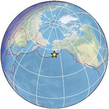
-
-
M 6.2 - 206 km S of Burica, Panama
2025-07-14 17:16:49 (UTC)6.179°N 82.681°W10.0 km depth
https://earthquake.usgs.gov/earthquakes/eventpage/us7000qclp/executive
-----------------------------------------------------------------------SPAIN REGION
FRKOM LINK
Two earthquakes hit close to Eurasia-Africa plate boundary
The first is 6.6
Depht 10km
And the second is moderate earthquake hit close to the coast of Spain
M5.2
Depht 10km https://earthquake.usgs.gov/earthquakes/eventpage/us7000qcif/executive#BREAKING: Airport roof collapses as Spain hit by powerful earthquake
.................................................................4.8
Izu Islands, Japan region
2025-07-14 13:53:18 (UTC-03:00)
10.0 km4.5
97 km SSW of Abepura, Indonesia
2025-07-14 11:24:26 (UTC-03:00)
27.9 km
3.2
36 km ESE of Malaga, New Mexico
2025-07-14 11:13:00 (UTC-03:00)
7.6 km
4.6
103 km NW of Ternate, Indonesia
2025-07-14 11:06:19 (UTC-03:00)
34.1 km
2.6
3 km W of Cobb, CA
2025-07-14 10:42:33 (UTC-03:00)
1.2 km
5.0
69 km NE of Masamba, Indonesia
2025-07-14 09:52:18 (UTC-03:00)
10.0 km
4.4
44 km ENE of Pedro Bay, Alaska
2025-07-14 09:18:02 (UTC-03:00)
134.8 km
4.7
80 km NE of Masohi, Indonesia
2025-07-14 08:37:02 (UTC-03:00)
10.0 km4.6
207 km E of Levuka, Fiji
2025-07-14 06:53:22 (UTC-03:00)
552.0 km
4.5
0 km SE of Kēng Tung, Burma (Myanmar)
2025-07-14 05:06:36 (UTC-03:00)
10.0 km
4.6
Auckland Islands, New Zealand region
2025-07-14 05:00:09 (UTC-03:00)
10.0 km5.0
228 km E of Ust’-Kamchatsk Staryy, Russia
2025-07-14 03:28:19 (UTC-03:00)
10.0 k4.1
43 km SSW of Jurm, Afghanistan
2025-07-13 18:18:38 (UTC-03:00)
191.8 km
4.3
31 km NE of Shwebo, Burma (Myanmar)
2025-07-13 18:04:00 (UTC-03:00)
10.0 km
© 2025 Created by 0nin2migqvl32.
Powered by
![]()
You need to be a member of Earth Changes and the Pole Shift to add comments!
Join Earth Changes and the Pole Shift