EARTHQUAKES Worldwide! (Frequently Updated)
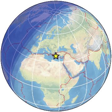
 Global Earthquake Maps
Regionally Specific Earthquake Maps
|
Related Informations:
Earthquakes during the poleshift Magnetic twist and the effects
|
Additional Information from the F.A.Q: Q: What is the "Earth Wobble"?
Q: How can I understand the Magnetosphere? - About the Magnetosphere
Q: Is there a relationship between disturbances in the magnetosphere and seismic activity? |
Altering Earthquakes:
As of late, I have observed that USGS and EMSC are a bit lax on their reports of earthquakes. Sometimes not seeing anything reported for hours from the last update, or seeing periods of 90-200 minutes with no earthquakes in between. My question is, are they leaving swarms of earthquakes out of their reports, or there are actually periods of no earthquakes?
SOZT: Greater than 90% of the earthquake activity is being altered by the USGS at present, which is under orders to prevent any clue being given to the public about the Earth changes caused by the presence of Planet X. Over a decade ago, the approach was to de-sensitize the live seismographs periodically, so the displays do not turn black worldwide, and to ignore the twice-a-day patterns showing up on these seismographs. Then any quakes that could be dropped were dropped. This was obvious to some who were watching the database manipulation. Quakes in the list would suddenly disappear. This was particularly the case where a quake happened in a remote location, or out in the ocean. Dumbing down the magnitude quickly followed, but in order to ensure the public did not notice, the USGS took control of all websites reporting quake statistics. At times, this control breaks, and discrepancies are reported to the public. Some countries rebel. Quake swarms are another source of control, as they pepper the databases with many quakes and skew the statistics, and thus are pulled from the database. Else the question is raised, why so many? EOZT
Will the USGS internet system be a reliable warning system for the European tsunami by registering on the net the New Madrid earthquake on the exact time it occurs?
SOZT: It will not be a lack of information from the USGS that will be the point of confusion during the earthquakes leading up to the New Madrid adjustment, it will be knowing which quake is the big one vs the many minor quakes preceding it. The USGS downgrades almost all earthquakes, to prevent meaningful statistics from being generated from their databases. They also exclude quakes whenever they can, but this is unlikely to happen in the New Madrid area as it is in the center of a populated land mass. Thus you will have magnitude 6 quakes that will be called a 5.2, magnitude 7 quakes called a 6.1, and when a magnitude 8 or greater quake occurs, it will be called a 6.9.
We would advise that rather than watching the USGS quake statistics, that you watch the Earth changes. The adjustment that will incite the European tsunami will involve bridges on the Mississippi breaking, and being impassable. The land to the west of the Mississippi will drop so that the Mississippi will become 50 miles wide in the state of Mississippi. Watch for this. The New Madrid adjustment will be several large quakes of magnitude 8-9, though will be listed as a lesser magnitude. As the N American continent continues to unzip up to and along the Seaway, the quakes will be less than a magnitude 8 but very destructive to Cleveland and Toledo and Buffalo and the inland locks along the Seaway. Thus it is not what the USGS says that should be watched, but the condition of the bridges on the Mississippi, the impact on the cities along the Seaway, and whether the inland locks are reported as inoperable. EOZT
Please collect earthquake-reports here. Significant Quakes or Magnitude 7+ can be posted separately.
[Edited by the Moderation]
Views: 566543
Comment
-
Comment by jorge namour 2 hours ago
-
M 6.5 - 36 km NNE of Olonkinbyen, Svalbard and Jan Mayen
2025-03-10 02:33:14 (UTC)71.197°N 8.193°W10.0 km depthhttps://earthquake.usgs.gov/earthquakes/eventpage/us6000pxvx/executive
-
-
4.1
10 km NW of Malibu, CA
2025-03-09 17:03:20 (UTC-03:00)
11.4 k https://earthquake.usgs.gov/earthquakes/eventpage/ci41075584/executiveM 4.6 - 121 km WNW of Mahabe, Madagascar
4.5
Bonin Islands, Japan region
2025-03-09 13:16:47 (UTC-03:00)
10.0 km4.3
5 km SSE of Boca de Yuma, Dominican Republic
2025-03-09 10:47:51 (UTC-03:00)
109.0 km4.7
4 km SSE of Gamut, Philippines
2025-03-09 06:46:45 (UTC-03:00)
74.1 km5.2
58 km ENE of Tatsugō, Japan
2025-03-09 02:57:57 (UTC-03:00)
38.7 km
4.8
114 km SSE of Sumbawa Besar, Indonesia
2025-03-09 01:31:10 (UTC-03:00)
64.9 km
5.1
56 km ENE of Tatsugō, Japan
2025-03-09 01:24:19 (UTC-03:00)
10.0 km
4.9
59 km ENE of Tatsugō, Japan
2025-03-09 01:20:54 (UTC-03:00)
37.5 km5.7
74 km ENE of Tatsugō, Japan
2025-03-08 20:42:54 (UTC-03:00)
26.0 km https://earthquake.usgs.gov/earthquakes/eventpage/us6000pxpv/executiveMagnitude 5.0
Region SOUTHERN GREECE
Date time 2025-03-09 00:13:08.6 UTC
Location 37.469 ; 21.735
Depth 18 kmMagnitude 4.4
Region GULF OF ADEN
Date time 2025-03-09 14:39:07.0 UTC
Location 13.410 ; 50.510
Depth 10 kmMagnitude 3.7
Region CUBA REGION
Date time 2025-03-09 15:36:38.0 UTC
Location 20.101 ; -74.588
Depth 42 kmMagnitude 5.2
Region RYUKYU ISLANDS, JAPAN
Date time 2025-03-09 05:57:56.6 UTC
Location 28.718 ; 130.181
Depth 28 kmMagnitude 5.7
Region RYUKYU ISLANDS, JAPAN
Date time 2025-03-08 18:54:03.5 UTC
Location 28.742 ; 130.223
Depth 15 kmmagnitud 4.5
Países afectados: Estados Unidos y Canadá
A 9 km de Washington, EE. UU. · 3 mar, 10:02 a.m.magnitud 5.4
A 6 km de Cayarani, Perú · 7 mar, 9:17 a.m.e magnitud 6.1
Países afectados: Bolivia, Chile y Argentina
A 105 km de Calama, Chile · 6 mar, 1:21 p.m.magnitud 5.5
A 65 km de Salina Cruz, Oax., México · 5 mar, 6:43 a.m.magnitud 5.4
Países afectados: India y Myanmar (Birmania)
A 51 km de Chongdan, Manipur, India · 5 mar, 2:36 amagnitud 3.8
A 4 km de Los Ángeles, California, EE. UU. · 3 mar, 3:13 a.m
-
Comment by Tracie Crespo on February 26, 2025 at 2:13am
-
Magnitude 6.1 Region MINAHASA, SULAWESI, INDONESIA Date time 2025-02-25 22:55:44.8 UTC Location 0.391 ; 124.830 Depth 10 km Distance 121 km S of Manado, Indonesia / pop: 451,000 / local time: 06:55:44.8 2025-02-26
102 km S of Tondano, Indonesia / pop: 33,300 / local time: 06:55:44.8 2025-02-26Source parameters provided by:
National Earthquake Information Center, U.S. Geological Survey -- Golden, United States (NEIC)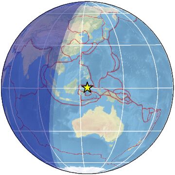
-
-
RED SEA DEAD SEA EGYPT REGIOM
MAY BE RELATED TO EARTHQUAKES IN SANTORINI GREECE REGION
https://www.facebook.com/61554943614743/videos/536927775481338
There is something very suspicious and dangerous that has recently and currently started to happen to the crystalline continental fault passing through the Red Sea and the Gulf of Aqaba, passing through the Dead Sea. Perhaps the suction of the Red Sea waters and their retreat on most of its shores during the past few days is due to the movement and expansion of the crystalline continental fault. These are signs and indications of danger, so prepare.
👇👇👇👇👇👇👇
✍️ Circulating 👌 in the news and all media and social media under the title of a very mysterious and suspicious phenomenon on the shores of the southern Sinai Peninsula in Egypt.. The waters of the Red Sea have withdrawn and receded tens of meters into the depths of the Red Sea and the secrets of the seabed are coming out to the shore.. Have the signs of the Hour appeared in Egypt 🤔🙄🤔???
.................................................................M 6.0 - 80 km SE of Lata, Solomon Islands
2025-02-23 18:16:18 (UTC)11.283°S 166.267°E36.0 km depthhttps://earthquake.usgs.gov/earthquakes/eventpage/us7000pfmk/executive
...........................................................4.5
61 km NNE of Āwash, Ethiopia
2025-02-23 21:52:18 (UTC-03:00)
10.0 km5.3
60 km NW of Āsbe Teferī, Ethiopia
2025-02-23 20:44:51 (UTC-03:00)
10.0 kmhttps://earthquake.usgs.gov/earthquakes/eventpage/us7000pfpk/executive
.............................................................FELT EARTHQUAKES MOROCCO TURKEY
4.9
222 km NNE of Barra Patuca, Honduras
2025-02-23 21:30:01 (UTC-03:00)
10.0 km5.2
122 km W of Panguna, Papua New Guinea
2025-02-23 19:50:10 (UTC-03:00)
10.0 km
4.4
38 km WNW of Hakui, Japan
2025-02-23 19:07:07 (UTC-03:00)
10.0 km26 km N of Waingapu, Indonesia
2025-02-23 16:21:17 (UTC-03:00)
46.5 km
4.8
38 km WNW of Hakui, Japan
2025-02-23 16:09:00 (UTC-03:00)
10.0 km
4.7
40 km SE of Wada, Japan
2025-02-23 16:07:52 (UTC-03:00)
86.2 km4.9
56 km SW of Wewak, Papua New Guinea
2025-02-23 10:54:27 (UTC-03:00)
10.0 km
4.7
42 km WNW of Tamarindo, Costa Rica
2025-02-23 09:18:07 (UTC-03:00)
35.0 km4.8
34 km SE of Tena, Ecuador
2025-02-23 04:25:17 (UTC-03:00)
10.0 kmsouth of the Fiji Islands
2025-02-23 03:36:23 (UTC-03:00)
514.0 km
5.0
292 km S of Bengkulu, Indonesia
2025-02-23 02:16:22 (UTC-03:00)
10.0 km
5.1
296 km SSW of Pagar Alam, Indonesia
2025-02-23 01:27:13 (UTC-03:00)
10.0 km
5.4
125 km SSE of Panguna, Papua New Guinea
2025-02-23 01:17:39 (UTC-03:00)
68.4 km
4.6
63 km SSE of Onagawa Chō, Japan
2025-02-23 01:08:06 (UTC-03:00)
62.6 kALBERTA CANADA 4.8
-
-
Campi Flegrei Vesuvip
NAPLES ITALY REGIOMhttps://www.facebook.com/photo?fbid=1078911087582642&set=a.4737...
Il Mondo dei Terremoti
sodrnoSpte81f0uu71ifhhui1utf6hBREAKING NEWS: a strong earthquake has just occurred inside the Campi Flegrei boiler. We don’t know exactly the magnitude and epicenter of the event yet, but the track of the Vesuvian Observatory speaks clearly, this is definitely the most intense earthquake of the day. Soon we will provide you with the revised data from INGV.
https://www.facebook.com/photo/?fbid=1078919177581833&set=a.473...
OFFICIAL DATA INGV: the strong earthquake warned at 00:19 had a magnitude of 3.9 and occurred between Solfatara and Pisciarelli at a depth of 2 km. In addition to the whale area, the earthquake was also strongly warned in the center of Naples, in Ischia, on the Domizio coast and on the Vesuvian coast between Portici, Ercolano and Torre Annunziata. The earthquake was preceded and followed by numerous events, including two M 3.0s that occurred at 23:45 and 23:46 More earthquakes are still happening and they still need to be evaluated by the Vesuvian Observatory. Keep in mind that since this afternoon over 150 earthquakes have been registered, including two 3.9: one at 15:30 in the Gulf of Pozzuoli and one at 00:19 near Solfatara.
Magnitude 3.9
Region SOUTHERN ITALY
Date time 2025-02-16 23:19:52.5 UTC
Location 40.829 ; 14.148
Depth 2 km
Distance 181 km ESE of Rome, Italy / pop: 2,318,000 / local time: 00:19:52.5 2025-02-17
10 km WSW of Naples, ItalyEARLIER
Magnitude 3.0
Region SOUTHERN ITALY
Date time 2025-02-16 14:30:02.1 UTC
Location 40.726 ; 14.097
Depth 10 km
Distance 20 km SW of Naples, ItalyMagnitude 2.7
Region SOUTHERN ITALY
Date time 2025-02-16 16:30:41.9 UTC
Location 40.833 ; 14.131
Depth 3 km
Distance 179 km ESE of Rome, Italy / pop: 2,318,000 / local time: 17:30:41.9 2025-02-16
12 km WSW of Naples, ItalY
...............................................................ETNA SICILY ITALY REGION
https://www.facebook.com/photo/?fbid=1078800384260379&set=pcb.1...
ETNA, THE FLOW HAS REACHED THE ALTOMONTANA TRACK: the lava outflow continues to progress slowly and in the past hours it has reached the Altomontana track, one of the most frequent and important trails of the volcano. The main front has cut the path in half and is crossing a small pine forest located at an altitude of about 1,850 meters. In the summit zone, the Strombolian activity is continuing by the South-East Crater, from which ash emissions have intensified in recent hours. Seppur modest, these emissions caused the temporary closure of the Catania airport.
...................................................................4.9
61 km SW of Champerico, Guatemala
2025-02-16 17:47:31 (UTC-03:00)
35.0 km
M 5.1 - 52 km N of Shahrak-e Kūlūrī, Iran4.3
28 km SW of Amorgós, Greece
2025-02-16 20:08:58 (UTC-03:00)
10.0 km4.1
26 km ENE of Firá, Greece
2025-02-16 17:55:58 (UTC-03:00)
10.0 km
-
-
M 6.0 - 6 km NNE of Metahāra, Ethiopia
2025-02-14 20:28:23 (UTC)8.956°N 39.934°E10.0 km depth
https://earthquake.usgs.gov/earthquakes/eventpage/us7000pdu6/executive
.........................................................magnitud 5.8
A 286 km de Kodiak, Alaska, EE. UU. · 13 feb, 8:59 p.m.magnitud 3.7
Países afectados: Estados Unidos y Canadá
A 17 km de Victoria, Columbia Británica, Canadá · 2:59 a.m.magnitud 3.6
A 4 km de Fairview, California, EE. UU. · 13 feb, 6:59 p.m.magnitud 5.1
A 2 km de Souk L'Qolla, MOROCCO 10 feb, 7:48 p.m.magnitud 3.6
Países afectados: Estados Unidos y México
A 7 km de San Bernardino, California, EE. UU. · 10 feb, 2:44 p.m.magnitud 5.9
A 66 km de Port Vila, Vanuatu · 9 feb, 9:09 p.m.4.8
43 km SW of Montecillos, Mexico
2025-02-14 12:26:55 (UTC-03:00)
10.0 km5.1
South Sandwich Islands region
2025-02-14 06:46:33 (UTC-03:00)
10.0 km
4.8
29 km NNE of Goroka, Papua New Guinea
2025-02-14 06:27:41 (UTC-03:00)
108.0 km
4.8
51 km SW of Angoram, Papua New Guinea
2025-02-14 05:09:58 (UTC-03:00)
116.4 km
4.7
211 km NNE of Barra Patuca, Honduras
2025-02-14 04:26:23 (UTC-03:00)
10.0 km
5.2
off the coast of Ecuador
2025-02-14 03:39:50 (UTC-03:00)
10.0 k2025-02-14 23:02:53
8 min ago
36.675 25.764 5 3.0 DODECANESE ISLANDS, GREECE
2025-02-14 22:45:18
25 min ago
36.647 25.786 12 4.0 DODECANESE ISLANDS, GREEC2025-02-14 20:18:55
2 hr 52 min ago
36.656 25.739 8 4.1 DODECANESE ISLANDS, GREECE
1 2025-02-14 20:17:45
2 hr 53 min ago
36.600 25.600 5 4.3 DODECANESE ISLANDS, GREECE
2025-02-14 20:15:40
2 hr 55 min ago
36.627 25.769 12 3.5 DODECANESE ISLANDS, GREECE
-
-
BREAKING NEWS: A powerful 7.6 magnitude earthquake occurred just over half an hour ago 200 kilometres southwest of the Cayman Islands, in the heart of the Caribbean Sea. According to current data, the quake occurred at a depth of only 10 km, therefore NOAA immediately issued a tsunami warning that is currently in effect for all countries facing the Caribbean Sea and the Gulf of Mexico.
01:40 AM UPDATE: The tsunami warning has returned to nearly every country, it remains in effect in Cayman Islands, Cuba and Jamaica.
https://www.facebook.com/photo/?fbid=1072627788210972&set=a.473...
-
-
M 7.6 - 209 km SSW of George Town, Cayman Islands
2025-02-08 23:23:14 (UTC)17.702°N 82.456°W10.0 km depthhttps://earthquake.usgs.gov/earthquakes/eventpage/us7000pcdl/executive
........................................................................
4.2
18 km E of Mesariá, Greece
2025-02-08 06:15:48 (UTC-03:00)
10.0 km
4.4
17 km NE of Firá, Greece
2025-02-08 06:10:06 (UTC-03:00)
10.0 km
5.1
13 km NE of Mesariá, Greece
2025-02-08 06:00:40 (UTC-03:00)
10.0 km
4.9
18 km NE of Firá, Greece
2025-02-08 05:36:04 (UTC-03:00)
10.0 km
-
-
Magnitude 6.0 Region SOUTH OF FIJI ISLANDS Date time 2025-02-07 10:26:58.8 UTC Location -23.924 ; -176.086 Depth 36 km Distance 323 km S of Nuku‘alofa, Tonga / pop: 22,400 / local time: 23:26:58.8 2025-02-07
320 km S of Tatakamotonga, Tonga / pop: 3,000 / local time: 23:26:58.8 2025-02-07Source parameters reviewed by a seismologist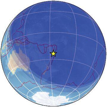
Magnitude 5.1 Region DODECANESE ISLANDS, GREECE Date time 2025-02-07 07:16:15.0 UTC Location 36.564 ; 25.631 Depth 7 km Distance 144 km N of Irákleion, Greece / pop: 137,000 / local time: 09:16:15.0 2025-02-07
25 km NE of Oía, Greece / pop: 3,300 / local time: 09:16:15.0 2025-02-07Source parameters reviewed by a seismologist
-
-
SantorinI GREECE
https://www.facebook.com/meteohellas/videos/584398624432249
the earth beneath the feet of the inhabitants does not stop shaking.
Newer amateur video shows the prevailing situation on the island of Santorini, at the time the seismic sequence is in full swing, and during yesterday's 5.1 R earthquake.
For the latest in our group Meteo Hellas🔴 VOLCANIC ERUPTION RECORDED IN GREECE, POPULATION BEGINS TO MIGRATE
https://www.facebook.com/carlos.aguela.9/videos/907753251240520
© 2025 Created by 0nin2migqvl32.
Powered by
![]()
You need to be a member of Earth Changes and the Pole Shift to add comments!
Join Earth Changes and the Pole Shift