Wild Weather, the Wobble Effect
TOTAL DESTRUCTION IN PARTS OF CEBU CITY, PHILIPPINES, 05.11.25
Massive flooding in Da Nang, Vietnam. 30.10.2025.
Giant waves crash over seawalls during a storm
in the suburbs of Taipei, Taiwan. 21.10.2025
"We warned at the start of ZetaTalk, in 1995, that unpredictable weather extremes, switching about from drought to deluge, would occur and increase on a lineal basis up until the pole shift. Where this occurred steadily, it has only recently become undeniable. ZetaTalk, and only ZetaTalk, warned of these weather changes, at that early date. Our early warnings spoke to the issue of global heating from the core outward, hardly Global Warming, a surface or atmospheric issue, but caused by consternation in the core. Affected by the approach of Planet X, which was by then starting to zoom rapidly toward the inner solar system for its periodic passage, the core was churning, melting the permafrost and glaciers and riling up volcanoes. When the passage did not occur as expected in 2003 because Planet X had stalled in the inner solar system, we explained the increasing weather irregularities in the context of the global wobble that had ensued - weather wobbles where the Earth is suddenly forced under air masses, churning them. This evolved by 2005 into a looping jet stream, loops breaking away and turning like a tornado to affect the air masses underneath. Meanwhile, on Planet Earth, droughts had become more intractable and deluges positively frightening, temperature swings bringing snow in summer in the tropics and searing heat in Arctic regions, with the violence of storms increasing in number and ferocity."
ZETATALK
Wild Weather, the Wobble Effect - Earth Changes and the Pole Shift
Views: 638457
Comment
-
Comment by Heather on July 1, 2013 at 3:51pm
-
check out the photo of the sun in this article
http://www.mnn.com/earth-matters/climate-weather/blogs/you-know-its...
You know it's hot outside when the traffic lights are meltingWIth temperatures hovering around 110 degrees in Kuwait right now, it shouldn't be too surprising to see something like a melted traffic light. What's even crazier? It's hotter than that in Phoenix right now.
Photo: Jets and Zeppelins/Flickr
Redditor Mohayat lives in Kuwait and snapped this amazing photograph of a traffic light literally melting under the hot summer sun. Here is the current weather and forecast for Kuwait.
-
Comment by KM on June 30, 2013 at 1:01am
-
http://www.huffingtonpost.com/2013/06/29/phoexix-heat-wave_n_352138...
Phoenix, Las Vegas Bake In Scorching Heat
By BRIAN SKOLOFF and CHRIS CARLSON 06/29/13 05:13 PM ET EDT

DEATH VALLEY, Calif. — Scorching heat blistered the Southwest on Saturday, where highs between 115 and 120 degrees were expected for parts of Arizona, Nevada and California through the weekend.
Forecasters said temperatures in sunbaked Las Vegas could match the record of 117 degrees Saturday. Phoenix also was expected to hit that mark, matching the record for June 29 set in 1994. And large swaths of California sweltered under extreme heat warnings, which are expected to last into Tuesday night – and maybe even longer.
Dan Kail was vacationing in Las Vegas when he heard that the temperature at California's Death Valley could approach 130 degrees this weekend. He didn't hesitate to make a trip to the desert location that is typically the hottest place on the planet.
"Coming to Death Valley in the summertime has always been on the top of my bucket list," the 67-year-old Pittsburgh man said. "When I found out it might set a record I rented a car and drove straight over. If it goes above 130 I will have something to brag about."
The forecast called for Death Valley to reach 128 degrees Saturday as part of a heat wave that has caused large parts of the western U.S. to suffer. Death Valley's record high of 134 degrees, set a century ago, stands as the highest temperature ever recorded on Earth.
-
Comment by lonne rey on June 29, 2013 at 1:12pm
-
France: an autumnal weather yesterday afternoon
june 29 2013
The week that we live in is, it has not escaped you, very cool ... while we are closer to the middle of summer ... Even the eastern regions that have previously been saved (after the short episode of intense heat of mid-month) experienced in all respects horrible weather . This last week of June is at the scale of France, the coolest month!
This cool for late June recalls the episode of bad weather experienced in late June 1981, when the maximum temperature did not exceed 11 to 14 ° C, with a gray sky and heavy rain.
A context weather season
With a depression centered on northern Europe, the cloudy and unstable returns concerned most of the country, sparing the Atlantic coast. These clouds, driven by a north wind chilled directly down the pole, have earned us this persistent gloom, whose highest point is reached since last Friday and now Saturday.
Temperatures below 10 ° C to seasonal averages
Friday afternoon, the regions extending from Midi-Pyrenees in the Franche-Comté and Rhône-Alpes, Auvergne or even Alsace, Lorraine and the Ile-de-France experienced weather conditions actually fall with a very low ceiling (stratus ubiquitous rain and moderate wind from the north-west). Temperatures struggled to reach 15 to 18 ° C over many cities.
Weather conditions are a far cry from the summer ...Rise in temperature from Sunday
On Sunday, with the direction of the current in the west and southwest Monday, temperatures begin to rise: between Friday and Monday, we will win in places more than 10 ° C. .. In feit we simply rejoin the middle of the season ...translated with google
Just for the record the temps from a year ago
-
-
June again too cold
the bilt - the Netherlands2013 threatens the books to go as a remarkably cold year. For the sixth month in a row it is indeed been too cold for the time of year.
The last time the six months in a row was colder than it was in 1985, reports the average KNMI. The average monthly temperature for June 2013, in De Bilt to 15.1 degrees to 15.6 normal. Especially at sea it was cool because the sea water is still too cold for the time of year.
Although the average temperature in June so disappointing, it was around June 18 that in much of the country it was briefly tropical warm. In Eindhoven it was then 32.4 degrees, the highest temperature of nationwide this month.
translated with google
-
-
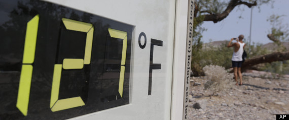
Historic, dangerous heat wave scorches western USA
All-time record temperatures are possible in Las Vegas, Reno and Flagstaff.

(Photo: Matt York, AP)
A blistering, potentially historic and record-breaking heat wave is beginning today in the West, and is forecast to last at least through the weekend.
Excessive heat warnings and watches have been issued today by the National Weather Service for most of Arizona, Nevada, California and parts of Utah. They are in effect through Monday.
"An excessive heat warning is issued when temperatures are forecast to reach dangerous levels that will stress the body if precautions are not taken," the weather service warns.
"Heat stroke symptoms include an increase in body temperature, which leads to deliriousness, unconsciousness and red, dry skin," according to a weather service online report. "Death can occur when body temperatures reach or exceed 106-107 degrees."
Infants and children, the elderly, as well as those with chronic medical conditions such as chronic kidney disease, asthma, hypertension and diabetes are at increased risk for heat-related illness, according to Robert Glatter, emergency room physician at Lenox Hill Hospital in New York. He says to prevent the adverse effects of heat-related illness, stay in a cool air-conditioned environment with access to plenty of cool fluids, mainly water.
The cause of the heat wave is a "massive and unusually strong high-pressure system" over the region, the weather service reports.

Extreme heat is supposed to hit the West on Friday and it could cause major travel woes for much of the country, whether you're flying, driving, or taking a train.
"Daytime temperatures will soar well into triple digits, and overnight lows will struggle to drop into the 70s and 80s," notes weather service meteorologist Mary Beth Gerhardt in a Weather Prediction Center report.
Notoriously hot Death Valley in California is forecast to reach 129 degrees, not far off the world-record high of 134 logged there exactly one century ago.
In some cities, record highs for any date throughout the year could be equaled or breached, says AccuWeather meteorologist Alex Sosnowski. Cities that could set all-time high temperature marks include Flagstaff, Ariz., Las Vegas and Reno, he adds.
An all-time record of 117 degrees could be broken Saturday in Las Vegas.
In Las Vegas Thursday afternoon, two Elvis impersonators and a performer costumed as the iconic "Welcome to Fabulous Las Vegas" sign said they still planned to keep up their routine of working the tourist corridor in the broad daylight and turning in for the evenings, heat notwithstanding.
"We'd much rather fight with the sun than fight with the drunk people," Elvis impersonator Cristian Morales said.
We're having a heat wave: Triple-digit heat out West: That's blazing hot
Utah isn't immune from the heat,either: Temperatures are expected to reach as high as 115 degrees in St. George, Utah, through the weekend.
"It's hard for us to say everyone should stay indoors when it's really hot," says David Heaton, the Southwest Utah Public Health Department public information officer. "There are always going to be folks going out during the day in hiking conditions. If you're going to go out, use caution, stay hydrated and watch for signs of heat exhaustion."
Little relief is in sight across the baked region: "A few isolated thunderstorms containing minimal precipitation will be possible along the higher elevations of the Rockies and Great Basin," according to Gerhardt. "Instead of providing relief from the heat this weekend, these dry storms will only enhance the fire weather threat across a very hot and dry region."
The National Weather Service is calling for temperatures to approach 120 degrees in Phoenix over the weekend. Phoenix has only been in the 120s three other times in history, according to Weather Channel meteorologist Chris Dolce.
Improbable as it might seem, the heat reminds Phoenix resident Anders Berg of his home in Sweden, where temperatures aren't likely to be much above 65 degrees this weekend. "It's like if it's a snowstorm in Sweden," he said. "You stay inside; you don't go out." The heat, like the bitter cold, isn't something to acclimate to, he said, but rather something to avoid.
While the West bakes this weekend, most of the East will see a humid, showery weekend, with heavy thunderstorms and an increased threat for flooding, AccuWeather forecasts.
Contributing: The Associated Press; Zach St. George, The Arizona Republic; Brian Passey, The Spectrum in St. George, Utah.


-
Comment by Wayne wilson on June 28, 2013 at 5:51pm
-
NASA launches IRIS sun-watching probe - June 28
NASA says the satellite's mission will be to examine a little-studied region of the sun in the hopes of improving space weather prediction."What is NASA trying to learn with this new satellite, which will be positioned exactly over the Equator at the same time each day? This is exactly what a scientist would need in order to ascertain a change in the Earth wobble! The satellite hugs the Earth, hugs the Equator in fact, so the angle of view toward the Sun should change only for the slow passing of the seasons. But during the daily Earth wobble, the angle of view toward the Sun changes as the N Pole is first pushed away from Planet X, then later compensates by bouncing back. The daily Figure 8 pattern also has the Earth first leaning to the right, then the left, a pattern that is overlaid over the polar push pattern.
"Since the wobble is palpable, measurable from the surface of the Earth by those measuring the Azimuth and timing of their sunrise and sunset, why does NASA need a satellite to give them details about the Earth wobble? More than the severity of the wobble can be ascertained, though the satellite will give this in exacting detail, showing and documenting trends. The magnetic blast coming toward Earth from the N Pole of Planet X will be measured, giving an early alert on the trend of steady increase expected to eventually devastate mankind’s electronics and satellites. After the announcement, NASA may admit the true use of this satellite, but we doubt it."


-
Comment by SongStar101 on June 27, 2013 at 2:05pm
-
Abnormal Percentages of Rainfall along East in June
http://www.accuweather.com/en/weather-news/east-us-poised-for-flood...

-
Comment by Gerard Zwaan on June 26, 2013 at 8:49am
-
In the east of the Netherlands it was around 0 near the ground during the night, only occurred once before at the end of June in 2000 since they started to measure in 1901.
-
Comment by Ryan X on June 26, 2013 at 2:13am
-
Granted this article does not reveal the "True" Cause, but another good example of extreme weather in Alaska. The words wobble and "drunken driver" describing the jet stream are prominently displayed.
WASHINGTON (AP) - The jet stream, the river of air high above Earth that generally dictates the weather, usually rushes rapidly from west to east in a mostly straight direction.
But lately it seems to be wobbling and weaving like a drunken driver, wreaking havoc as it goes. The more the jet stream undulates north and south, the more changeable and extreme the weather.The most recent example occurred in mid-June when some towns in Alaska hit record highs. McGrath, Alaska, recorded an all-time high of 94 degrees on June 17. A few weeks earlier, the same spot was 15 degrees, the coldest recorded for so late in the year.
http://www.komonews.com/news/national/96-in-Alaska-Weather-extremes...
-
-
http://saskatoon.ctvnews.ca/atchison-stay-away-from-the-river-1.133...
Atchison: Stay away from the river
ater levels on the South Saskatchewan River have officially peaked, according to the City of Saskatoon. The river is currently higher than it’s been in 100 years.
On Saturday, the Saskatchewan Water Security Agency began releasing water from Gardiner Dam at a rate of 2,000 cubic metres per second to deal with inflows into Lake Diefenbaker that are 12 times the normal rate of 500 cubic metres per second.
By mid-afternoon Sunday the river through Saskatoon had risen about 30 centimetres above the level seen during 2005.
SEARCH PS Ning or Zetatalk
Nancy Lieder, Emissary of the Zetas.
https://poleshift.ning.com/xn/detail/3863141:Comment:1168188
Awakening to the Alien Presence ZetaTalk
The truth will likely never to be known to the public but be washed away in the Nibiru panic soon to engulf the world.
The Worst of the Cover-Up
https://poleshift.ning.com/profiles/blogs/the-worst-of-the-cover-up
Main Establishment Lies
https://poleshift.ning.com/profiles/blogs/main-establishment-lies
Donate
© 2025 Created by 0nin2migqvl32.
Powered by
![]()
You need to be a member of Earth Changes and the Pole Shift to add comments!
Join Earth Changes and the Pole Shift