|
Weather: |
Tides and Whirlpools:
|
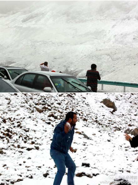
"We warned at the start of ZetaTalk, in 1995, that unpredictable weather extremes, switching about from drought to deluge, would occur and increase on a lineal basis up until the pole shift. Where this occurred steadily, it has only recently become undeniable. ZetaTalk, and only ZetaTalk, warned of these weather changes, at that early date. Our early warnings spoke to the issue of global heating from the core outward, hardly Global Warming, a surface or atmospheric issue, but caused by consternation in the core. Affected by the approach of Planet X, which was by then starting to zoom rapidly toward the inner solar system for its periodic passage, the core was churning, melting the permafrost and glaciers and riling up volcanoes. When the passage did not occur as expected in 2003 because Planet X had stalled in the inner solar system, we explained the increasing weather irregularities in the context of the global wobble that had ensued - weather wobbles where the Earth is suddenly forced under air masses, churning them. This evolved by 2005 into a looping jet stream, loops breaking away and turning like a tornado to affect the air masses underneath. Meanwhile, on Planet Earth, droughts had become more intractable and deluges positively frightening, temperature swings bringing snow in summer in the tropics and searing heat in Artic regions, with the violence of storms increasing in number and ferocity."
From the ZetaTalk Chat Q&A for February 4, 2012:
The wobble seems to have changed, as the temperature in Europe suddenly plunged after being like an early Spring, Alaska has its coldest temps ever while the US and much of Canada is having an extremely mild winter. India went from fatal cold spell to balmy again. Has the Earth changed position vs a vs Planet X to cause this? [and from another] Bitter cold records broken in Alaska - all time coldest record nearly broken, but Murphy's Law intervenes [Jan 30] http://wattsupwiththat.com/2012/01/30/bitter-cold-records-broken-in-alaska Jim River, AK closed in on the all time record coldest temperature of -80°F set in 1971, which is not only the Alaska all-time record, but the record for the entire United States. Unfortunately, it seems the battery died in the weather station just at the critical moment. While the continental USA has a mild winter and has set a number of high temperature records in the last week and pundits ponder whether they will be blaming the dreaded "global warming" for those temperatures, Alaska and Canada have been suffering through some of the coldest temperatures on record during the last week.
There has been no change in the wobble pattern, the wobble has merely become more severe. Nancy noted a Figure 8 format when the Earth wobble first became noticeable, in early 2005, after Planet X moved into the inner solar system at the end of 2003. The Figure 8 shifted along to the east a bit on the globe between 2005 and 2009, (the last time Nancy took its measure) as Planet X came closer to the Earth, encountering the magnetic N Pole with a violent push earlier in the day. But the pattern of the Figure 8 remained essentially the same. So what changed recently that the weather patterns became noticeably different in late January, 2012?
The N Pole is pushed away when it comes over the horizon, when the noon Sun is centered over the Pacific. This regularly puts Alaska under colder air, with less sunlight, and thus the historically low temps there this January, 2012 as the wobble has gotten stronger. But by the time the Sun is positioned over India, the N Pole has swung during the Figure 8 so the globe tilts, and this tilt is visible in the weather maps from Asia. The tilt has forced the globe under the hot air closer to the Equator, warming the land along a discernable tilt demarcation line.
The next loop of the Figure 8 swings the globe so that the N Pole moves in the other direction, putting the globe again at a tilt but this time in the other direction. This tilt is discernable in weather maps of Europe, again along a diagonal line. Depending upon air pressure and temperature differences, the weather on either side of this diagonal line may be suddenly warm or suddenly cold. The tilt and diagonal line lingers to affect much of the US and Canada, but the Figure 8 changes at this point to be an up and down motion, pulling the geographic N Pole south so the US is experiencing a warmer than expected winter under a stronger Sun. Then the cycle repeats, with the magnetic N Pole of Earth pushed violently away again as the Sun is positioned over the Pacific.
From the ZetaTalk Chat Q&A for April 6, 2013:
Would the Zetas be able to let us know what is causing the early break-up of the Arctic Ice, the ice seems to have taken on a swirling pattern at the same time, would this be wobble related? [and from another] http://www.vancouversun.com/news/national/Canada+Arctic+cracks+spec... The ice in Canada’s western Arctic ripped open in a massive “fracturing event” this spring that spread like a wave across 1,000 kilometres of the Beaufort Sea. Huge leads of water – some more than 500 kilometres long and as much as 70 kilometres across – opened up from Alaska to Canada’s Arctic islands as the massive ice sheet cracked as it was pushed around by strong winds and currents. It took just seven days for the fractures to progress across the entire area from west to east. [and from another] http://earthobservatory.nasa.gov/IOTD/view.php?id=80752&src=iot... A high-pressure weather system was parked over the region, producing warmer temperatures and winds that flowed in a southwesterly direction. That fueled the Beaufort Gyre, a wind-driven ocean current that flows clockwise. The gyre was the key force pulling pieces of ice west past Point Barrow, the northern nub of Alaska that protrudes into the Beaufort Sea.
The Figure 8 formed by the N Pole during the daily Earth wobble has shifted somewhat to the East, due to Planet X positioned more to the right of the Earth during its approach. This was anticipated, and well described in ZetaTalk, the Earth crowding to the left in the cup to escape the approach of Planet X, so the angle between these two planets would change slightly. This shift of the Figure 8 to the East is due to the push against the Earth’s magnetic N Pole occurring sooner each day than prior. Thus instead of occurring when the Sun is high over the Pacific, over New Zealand, it is now occurring when the Sun is high over Alaska. All the wobble points have shifted eastward accordingly.
This has brought a lingering Winter to the western US, and a changed sloshing pattern to the Arctic waters. Instead of Pacific waters being pushed through the Bering Straits into the Arctic when the polar push occurs, the wobble is swinging the Arctic to the right, and then later to the left, creating a circular motion in the waters trapped in the Arctic. Since the Earth rotates counterclockwise, the motion also takes this path. This is yet another piece of evidence that the establishment is hard pressed to explain. They are attempting to ascribe this to high pressure and wind, all of which are not new to the Arctic, but this circular early breakup of ice in the Arctic is new.
Comment
US: Snowiest April and Coolest April
For a printable version of the climate summary which includes more figures, data tables, and state summaries, click here.
Region Breakdown
The cooler conditions of March continued into April across the High Plains Region. Average temperatures were well below normal for the majority of the Region and in stark contrast to last year when many locations were in the top ten warmest on record. A rough southwest to northeast temperature gradient was apparent with average temperatures which were near normal across southwest portions of Colorado and Wyoming and up to 15.0 degrees F (8.3 degrees C) below normal in North Dakota and northeastern South Dakota.
Even with a late month warm-up, these cooler conditions caused locations in each state to be ranked in the top ten coolest Aprils on record. These cooler conditions were also accompanied by wintry weather and some locations ranked in both the top ten coolest and snowiest Aprils on record. Aberdeen, South Dakota had its coolest and 2nd snowiest April on record. The average temperature in Aberdeen was 34.9 degrees F (1.6 degrees C) which was 9.5 degrees F (5.3 degrees C) below normal (period of record 1893-2013). The old record occurred in 1950 with an average temperature of 36.0 degrees F (2.2 degrees C). More records occurred in Rapid City, South Dakota which had both the coolest and snowiest April. The average temperature was only 36.7 degrees F (2.6 degrees C) in Rapid City, and at 8.3 degrees F (4.6 degrees C) below normal, this temperature was able to easily beat the old record of 38.0 degrees F (3.3 degrees C) also set in 1950 (period of record 1942-2013).
[HPRCC News; 15 May 2013]
Here are some of daily high temperature records from May 14, 2013. Most locations had temperatures 20-30 degrees above their normal high temperature for the day. Furthermore, the locations of Omaha, Lincoln, and Grand Island all reached the 100 degree mark the earliest in their respective periods of record. The average time those cities hit the century mark is around the first week of July. These record high temperatures come just two days after some locations set daily low temperature records. During the morning hours of May 12, 2013 Omaha, Lincoln, and Norfolk had low temperature records of 32, 31, and 29, respectively. That is roughly a 70 degree temperature swing in approximately 60 hours(12th at 4am - 14th at 4pm).
This is a huge sign of Wobble!
The Omaha World-Herald reports that May 14 is the earliest day on record that the temperature in Omaha has reached triple digits, according to data from the National Weather Service. The temperature hasn’t been in that range in Omaha so early in the year since 1871.
In fact, Barbara Mayes of the National Weather Service says the official number could get even hotter before the day is over.
Amazingly, on Sunday there was still snow on the ground while on Tuesday, most residents were wearing shorts and sunscreen.
The largest temperature change on record within a 24 hour period occurred in Loma, Montana in 1972 when the temperature changed from -54 to 49 °F.
So, why was there such a dramatic shift in temperatures?
Dry air heading up from the Gulf of Mexico is to blame for both the extreme high and low temperatures, Mayes said that and a mixing of weather in the upper and lower levels of the atmosphere have led to a spike in temperatures across the region. On Tuesday, it was 103 degrees in Sioux City, Iowa and 100 degrees in Columbus, Ohio.
Adding to the weather drama, temperatures were already beginning to plummet in Omaha, with weather expected to be significantly cooler on Wednesday.
Happening right now. Mile wide tornado near Dallas TX with grapefruit sized hail
http://dfw.cbslocal.com/2013/05/15/tornadoes-large-hail-keeps-north...
The tornado, north of Evant, North Texas. Picture: Bruce Hansen via KWTX
PEOPLE have been killed by "grapefruit"-size hailstones as a tornado brings down buildings in Texas.
Hood County sheriff confirms fatalities, multiple injuries and extensive damage following the tornado, NewsBreaker reported.
The tornado, reported to be a mile-long is reported to be heading towards Cleburne, Texas.
"LIFE THREATENING SITUATION! Mile-wide tornado heading straight north now toward Cleburne, TX! TAKE COVER NOW! " reported Reed Timmer, of TVN.
Ryan Sloane of CNN reported that at least 10 people were injured in Hood County, Texas, with people trapped in homes.
The tornado slammed into the North Texas lakefront town of Granbury, demolishing homes and injuring an undetermined number of people, Houston Chronicle reported.
The tornado - part of a system of severe thunderstorms that spawned several tornadoes across North Texas - dropped large hail.
Police reported the hardest hit area was the Rancho Brazos subdivision and adjoining areas along Lake Granbury.
Another tornado hit the small town of Millsap, about 65km west of Fort Worth. Parker County Judge Mark Kelley said roof damage was reported to several houses and a barn was destroyed.http://www.perthnow.com.au/news/world/fatalities-in-hood-county-tex...
The official hurricane season in the Pacific east, starts on: June 1 and ends November 30, today is: 05/15/13, we have the first tropical storm, named: ALVIN.
Source: http://www.nhc.noaa.gov/graphics_ep1.shtml?5-daynl#contents
http://www.bbc.co.uk/news/uk-england-devon-22536139
Snow has fallen in parts of Devon in what has been described as "fairly unusual" weather for May.
Winds of up to 65mph also struck the South West coast overnight with a number of trees coming down, some blocking roads.
Western Power Distribution said homes in Cornwall were still without power after thousands were cut off overnight.
Two inches of snow also fell in Shropshire overnight and people have been warned to prepare for flooding.
Gavin Fabiani-Layman Princetown residentI went to walk the dog and opened the front door to a blizzard of snow”
Fourteen flood alerts are still in place in Devon and Cornwall following heavy rain on Monday.
Sheila Coates, from Princetown, told BBC Radio Devon: "It's crazy. When I went to bed last night I couldn't see out of my front window for the snow.
"I've lived here all my life and I've never known weather like it at this time of year."
'It was mad'
Gavin Fabiani-Laymon, who also lives in Princetown, took a photo of the snow and said it lasted "about an hour".
"I went to walk the dog and opened the front door to a blizzard of snow.
"It was mad, it took me by surprise," he said.
The MET office said the snow which fell in Devon was "a transient feature".
Forecaster Philip Avery said: "May snowfall is unusual but not unheard of, even in southern England.
"Snow has even managed to fall into June… but that really is a rarity.
"The last really widespread snowfall in May was 17th May 1955 when much of England and Wales was affected by several hours of snow.
"Coincidently, Devon also saw significant snow on 17th May 1935."
He said the snow was caused by very wet and windy weather across the region on Tuesday combined with falling temperatures after sunset.
The winds are expected to ease during Wednesday with the weather getting drier and brighter.
Massive Ice Bank Demolishes Homes on Manitoba Lake (May 10)
One minute, cottage owners on the southern shore of Manitoba’s Dauphin Lake were cooking on their barbecues, admiring the views across the still-frozen ice.
The next minute, that ice was rumbling up the shore like a giant nine-metre-high bulldozer, tearing apart their decks, then slicing through some homes and tipping others on their sides.
“The whole thing happened in about ten minutes,” said Clayton Watts, the deputy reeve of the Rural Municipality of Ochre River.
“We had people barbecueing on their decks. They turned around to go inside to get something, they came back out and their decks were ripping apart,” he added.
“It was like a freight train coming through, they say.”
A state of emergency has been declared in this rural municipality near Winnipeg after the giant wall of ice destroyed 12 homes on Friday. About 20 homes on three streets were damaged, and many were destroyed.
Strong winds pushed ice on Dauphin Lake onto homes and cottages on Ochre Beach, a summer community about 200 kilometres northwest of Winnipeg.
“Fortunately, nobody was hurt,” Deputy Reeve Clayton Watts said. “There was extensive damage, though.”
Some homes were completely destroyed. Others, like the one belonging to Donna Billows, were filled up when the charging ice flow pushed though doors and windows.
“I happened to look out the window and saw the ice just coming, just moving so quickly,” Billows told CTV News.
Billows, who was sitting down for dinner with her husband at the time, said she had little time to react.
“He said ‘Grab your purse, grab whatever you can. Get the keys. We’ve got to get out of here,’” Billows said.
Her home was packed with ice.
The community has rallied around Billows and others affected by the disaster.
“There were people working here that I didn’t even know who they were,” Billows said. “They just came in and said “What can we do?”
But just two years after dealing with floods that caused extensive damage in the community, Billows has had enough.
“Really, I don’t think I want to live here anymore,” she said.
Dennis Stykalo’s vacation home, which his family has owned for 38 years, was completely destroyed.
“Ice has come on this property historically over the years but never this close or of this magnitude,” he said.
Sources
http://www.ctvnews.ca/canada/huge-wall-of-ice-on-manitoba-lake-demo...
http://news.nationalpost.com/2013/05/11/owners-pick-through-remains...
http://www.cbc.ca/news/canada/manitoba/story/2013/05/10/mb-ochre-ri...
Drought-stricken Panama orders power rationing, closes schools [Reuters; 7 May 2013]
May 7 (Reuters) - Panama on Tuesday ordered government offices and private businesses to slash their power consumption and temporarily closed schools in response to a drought that has sapped the country's hydroelectric energy supply.
Opening hours for government offices will be reduced, while supermarkets, bars, cinemas, restaurants, casinos and other night spots would have to close between 10 p.m. and 6 a.m. from Monday to Thursday, according to a statement from the president's office.
Private businesses in the tropical Central American nation will also be forced to cut air-conditioning use by four hours a day, beginning Wednesday. It's unclear how long the rationing will last, though government officials say they would reconsider on Sunday how soon they could re-open schools.
Panama, one of Latin America's fastest-growing economies, uses hydroelectric power to generate 60 percent of its electricity.
But reservoirs are now low after months without rain.
The Panama Canal, which transports about five percent of world trade, is unaffected by the power rationing because it produces its own energy, a spokeswoman said.
The drought has killed hundreds of cattle, damaged crops, and caused some $200 million in losses in Panama. The government on Tuesday declared a drought emergency in four provinces, representing about a third of the nation's territory. (Reporting by Lomi Kriel; Editing by Paul Simao)
Shocking cold and snow in central U.S., first May snow on record in Arkansas
The third day of a brutal snap of wintry weather – in May – is shattering records in the central U.S. After the biggest snows ever observed in the month of May in Iowa, Minnes... Thursday, Arkansas experienced its first May snowflakes in history today.
The National Weather Service in Little Rock broke the news about the historic flakes with a tweet noting snow and/or sleet had been reported at 3 airports in the northwest part of the state.
Northwest Arkansas wasn’t the only location experiencing a historic snowfall. Kansas City experienced its first accumulating May snow (0.5 inches) since 1907 and as much as 6 inches fell in Missouri. Thursday afternoon’s Royals home game was called off due to a wintry mix of precipitation that changed to snow in the evening.
Here are some other notable snowfall records from the central U.S. from Thursday and today:
* Tulsa, Oklahoma experienced its latest spring snow on record
* Rochester, Minnesota’s 14.0 inches of snow Thursday was more than 3 times the combined total of all May snow (4.3 inches) since 1886 and its 4th snowiest day on record in any month.
* Eau Claire, Wisconsin’s 8.7 inches and Des Moines Iowa’s 3.4 inches Thursday were the greatest May snow totals on record for those cities.
http://www.washingtonpost.com/blogs/capital-weather-gang/wp/2013/05...
Video of the Tornado in: Italy, Emilia Romagna Region, at: 14:00 GMT, 11 injured, several houses destroyed, fields and crops also affected.
This free script provided by
JavaScript Kit
© 2025 Created by 0nin2migqvl32. Powered by
You need to be a member of Earth Changes and the Pole Shift to add comments!
Join Earth Changes and the Pole Shift