Prelude to Adjustments of N American Continent: The evidence is here. [Part 2]
Per the Zetas sequence during the 7 of 10, 7 of 10 Sequence, "what is holding the N American continent together has thus eased, so that when (8) the Japan adjustments are made, there is less holding the N American continent in place than before, and (9) the New Madrid gives way". Nancy has been presenting/giving us the evidence of a prelude to adjustments of the North American continent in her weekly newsletter or weekly chats.
http://www.zetatalk.com/newsletr/archives.htm
http://www.zetatalk.com/index/ningarch.htm
I picked out 53 items related to a prelude to adjustments of the North American continent from the newsletter since 2009, to show a part of the quotation from #1 to #31, items since 2010, on Part 1 and from #32 to #53, items in 2009, on Part 2.
---------------------------------------------------------------------
Part 1: Prelude to Adjustments of N American Continent: The evidence is her...
---------------------------------------------------------------------
List of the items (Part 2: #32-#53; in 2009);
32) California Cringing; Nov 15, 2009: http://www.zetatalk.com/newsletr/issue159.htm
33) Earth Roar; Oct 18, 2009: http://www.zetatalk.com/newsletr/issue155.htm
34) Water Main Breaks; Sep 13, 2009: http://www.zetatalk.com/newsletr/issue150.htm
35) Collapsing Bridges; Aug 30, 2009: http://www.zetatalk.com/newsletr/issue148.htm
36) Unstable Dams; Aug 9, 2009: http://www.zetatalk.com/newsletr/issue145.htm
37) Earthquake Lights; Jul 26, 2009: http://www.zetatalk.com/newsletr/issue143.htm
38) Sinking/Rising Land; Jul 26, 2009: http://www.zetatalk.com/newsletr/issue143.htm
39) Flaming Water; Jul 26, 2009: http://www.zetatalk.com/newsletr/issue143.htm
40) Quake Patterns; Jul 12, 2009: http://www.zetatalk.com/newsletr/issue141.htm
41) Falling Down; Jul 12, 2009: http://www.zetatalk.com/newsletr/issue141.htm
42) Brooklyn Building Collapse; Jun 28, 2009: http://www.zetatalk.com/newsletr/issue139.htm
43) Falling Down; May 23, 2009: http://www.zetatalk.com/newsletr/issue134.htm
44) Quake Ramifications; May 2, 2009: http://www.zetatalk.com/newsletr/issue131.htm
45) Booms and Shaking; Mar 8, 2009: http://www.zetatalk.com/newsletr/issue123.htm
46) North America on the Rack; Feb 15, 2009: http://www.zetatalk.com/newsletr/issue120.htm
47) Continental Divide; Jan 18, 2009: http://www.zetatalk.com/newsletr/issue116.htm
48) Harmonic Tremor; Jan 11, 2009: http://www.zetatalk.com/newsletr/issue115.htm
49) Caldera Eruptions; Jan 11, 2009: http://www.zetatalk.com/newsletr/issue115.htm
50) New Madrid Booms; Jan 11, 2009: http://www.zetatalk.com/newsletr/issue115.htm
51) Shifting Ground; Jan 4, 2009: http://www.zetatalk.com/newsletr/issue113.htm
52) Quake Uptick; Jan 4, 2009: http://www.zetatalk.com/newsletr/issue113.htm
53) 6 on 1-10 Scale; Jan 4, 2009: http://www.zetatalk.com/newsletr/issue113.htm
---------------------------------------------------------------------
[Part 2]
32) California Cringing
Per the Zetas, the N America continent is being put under a bow stress, as the Aleutian Islands are pulled toward the tip of Mexico. The N American continent has a flat top, a straight line running from Japan to Iceland, so cannot roll in place. Thus it is being pulled at a diagonal.
The center of this bow is in California near San Diego. The tension in the rock, pulled into a bow, have expressed recently in the many breaking water mains in San Diego and LA, and a roaring sound near San Diego. Quakes have likewise started to pick up in the area. But there are more signs of stress. On September 6, 2009 workmen discovered a cracked beam on the Bay Bridge connecting the city of San Francisco and Oakland, while doing routine repairs. Temporarily, a section of the bridge was closed to replace the cracked beam. A month later a cable snapped on the bridge, dropping the cable and 5,000 pounds of metal onto the roadway and narrowly missing commuters.
Water mains continue to break at an alarming rate along the coastline in southern California, sometimes dramatically.
But beyond breaking bridges and water mains, many in southern California are smelling sulfur! And seeing earthquake lights too. Quotes below are from a thread started on October 27, 2009 on the GodlikeProduction messageboard.
The smell of sulfur often accompanies rising magma, and can arise from fault lines prior to an earthquake. Since no major quakes have occurred in the LA area in the 3 weeks following these reports of sulfur smells, this appears to be simply more stress in the LA area and west into the desert. The Zetas have warned of an unknown fault line, running from the San Diego/LA area up toward Mammoth Lake in the Sierras, which will result in Mammoth Lake being an erupting volcanoe prior to the pole shift. Is Magma rising?
33) Earth Roar
You're heard of the Taos, NM hum, which lately has been documented in diverse places such as Green Bay, WI, and now Calgary. Booms and shaking are another aspect of rock under stress, breaking and vibrating, nothing new since Planet X arrived in the vicinity in 2003. The Seattle drums were never adequately explained, and now St. Paul, MN also reports a mysterious drum beat accompanied by regular shaking. But lately the booms and drums and shaking and humming have stepped up the pace - to a roar. This roar has been heard from San Diego to Vancouver to the mountains in Virginia and West Virginia. Those hearing the roar struggle to describe it, but someone in West Virginia captured this on an audio file, a small sample of which is the link below. This is more than the hum or a beat. This has evolved to a roar or a screech.
Per the Zetas, this is a result of the increasing stress the N American continent is under as it bows. The center of the bow is at San Diego. There, the roar apparently sounds like a plane about to crash.
San Diego is not the only place to hear a screech. An earthquake sensitive in Tennessee reports this has also emerged in her area.
Per the Zetas, this type of complaint from rock under stress can be expected the whole week prior to the pole shift, when rotation stoppage will force the crust to be in conflict with the core, which wants to continue to turn.
34) Water Main Breaks
Like the proverbial canary in the coal mine, water main breaks are one of the first indicators of earth movement. Buried in the ground, and often brittle from decades of use, they are put under stress when the ground shifts. Other signs of ground movement featured in this newsletter recently are collapsing bridges, unstable dams, sinking or rising land, buildings falling down, imploding buildings and booms. A rash of water main breaks within the past month, with multiple breaks in a single location, show that something other than old pipes and coincidence is afoot. Many of these breaks are accompanied by other signs of ground movement, such as booms or the smell of methane gas. In San Diego several water main breaks happened in close proximity to each other, one after the other. Days later a large main broke in LA, trapping a fire engine in the hole, while another main broke in Studio City. Note that California is showing other signs of stress, in that San Francisco had an odd unexplained methane gas odor just weeks before the San Diego water main breaks.
The Zetas have explained that San Diego is a stress point as it is the center of a bow which stretches from the Aleutian Islands to the tip of Mexico. Until the New Madrid Fault adjusts, this bow is pulling on the rock. It is no wonder that San Francisco had methane gas released, and a week later, water mains in San Diego and LA snapped.
The Crandall Canyon mining disasters on August 7, 2007 was near Salt Lake City, per the Zetas a result of the stress of the bowing on the West Coast. No wonder that a couple breaks in the water system near the hills there caused a geyser at the University. As with the San Diego/LA breaks, there were multiple breaks at the same time.
The diagonal stress on the North American continent pulls Mexico to the west while New England continues to tug east during the globe's daily rotation. This is putting increasing stress on the New Madrid Fault, reaching into Texas where swarms of quakes are strong enough to be felt in Dallas, TX and booms like the recent boom in Gatesville, TX have the populace concerned. Per the Zetas, the land west of the Mississippi will be drawn down as the New Madrid adjusts. In addition, the southeast US is being pulled down as the Atlantic is pulled apart. The coastline along the Gulf is sinking, adjusting, for both these reasons and this certainly includes Corpus Christi, TX where water main breaks are overwhelming the city's resources.
River bottom cities are also highly vulnerable, as per the Zetas land with little support in the rock strata sinks, so this is where the rivers flow. This vulnerability can be seen in two cities - Lousville, KY and Wheeling, WV - where multiple water main breaks occurred on the same day for both cities.
35) Collapsing Bridges
Someone noted in an email to me documenting that the pace of collapsing bridges, worldwide, seems to have picked up lately. During the past two months, bridges have collapsed in India, Ireland, Winnipeg, Iowa, Mexico, and China. In India, a bridge that stood for the past 100 years collapsed without explanation. In Ireland, Winnipeg, and Mexico, the collapse is ascribed to excess or erratic tides undermining the foundations of bridge footings. And in Iowa, ascribed to a particularly heavy truck. But aren't tides and heavy trucks a normal occurrence? What is going on here?
The Zetas have long predicted collapsing bridges, along with other Earth changes such as train derailment, buckling roadways, and sinkholes. This will greatly increase in the last weeks, making travel difficult if not impossible.
The individual who noted an increase in collapsing bridges also points out that imploding buildings and derailing trains have also increased during the past two months, confirming the Zeta predictions that such Earth changes are related and will all be on the increase at the same time.
36) Unstable Dams
Major dams, based on solid rock which presumably should not move unless a major quake strikes the area, are increasingly becoming a concern of emergency management teams. Leakage and sinkholes are a concern at the Hanson Dam on the Green River of late.
The cause of the sink holes is, per insider information, unknown.
That an immense catastrophe would occur should one of the major dams break is not contested.
And it is not just dams along the west coast, or the Hoover Dam, of concern. Dams in the Appalachian Mountains are also becoming unstable. The Lake Cumberland Dam above Nashville, Tennessee is becoming unstable too. The dam weakened at the same time a train derailment in the area occurred, and per the Zetas, this is no accident.
37) Earthquake Lights
Earthquake lights are in the news, at least in the Milwaukee Examiner news and in a spate of MUFON reports. The issue is slowly heating up because the incidence is increasing. They have been reported through history, associated with earthquake or occurring before earthquakes. If we're now seeing them across the US, this is a certain indication that the rock of the North American continent is under stress, as the Zetas have stated.
A dramatic video of Earthquake Lights was captured in China on May 12, 2008, 30 minutes prior to the Sichuan earthquake.
Reports describe these lights as multicolored, lighting up the entire sky, and often traveling horizontally. For instance, in Saratoga Springs, NY on February 19, 2009.
And in Lafayette, IN on February 11, 2009.
And from Leicester, NY on December 30, 2008.
And from Hilmar, CA on December 27, 2008.
And from Newark, NJ on December 20, 2008.
And from Portland, OR on December 21, 2008.
And from Rochester, PA on January 8, 2009 and Northwest, CT on December 29, 2008. These incidents continue, and recently in July, 2009 have hit the message board again. What causes earthquake lights? Wikipedia lists a number of theories, including rock under stress releasing electromagnetic bursts, methane gas released from pockets under pressure briefly flashing when lit, and even recombinant hydrogen and oxygen.
Examining these theories reduces the likely cause to electromagnetic bursts from rock under pressure. Recombinant hydrogen and oxygen is an unproven theory. Methane gas release has occurred in recent years, as the famous Earth Fart day on January 9, 2007, crossing oceans to strike Australia and the UK as well as the continential US. However, the predominant symptom of methane gas release is a smell of rotten eggs. When lighting, methane creates Light Towers, not multicolored light moving horizontally. Static on the radio from electromagnetic bursts released by rock under stress is a known precursor to an earthquake. The Zetas have confirmed, and explained the electromagnetic radio screeches are a sign of pending earthquakes. This is in fact the most accurate means of predicting a pending earthquake. It is these screeches that send pets fleeing and that causes static on the radio.
38) Sinking/Rising Land
A beach in Alaska suddenly heaved, rising 20 feet, and geologists are confused. No earthquake had occurred with enough force to cause this. What caused the beach to rise?
The Zetas have mentioned a bow stress on the N American west coast, all the way from the Aleutian Islands to the tip of Mexico. This is another proof that this bow stress exists! A torque, rather than the compression or slip slide of a large earthquake, caused the land to shift.
Land up in Alaska, land down in Germany. For unknown and unexplained reasons, a mass of land, long stable and populated, slid off into a nearby lake. Germany was also the site of the first dramatic incident of an imploding building, on March 3, 2009.
39) Flaming Water
Tap water in a Colorado household has lately become "flaming water", and the cause has been cited as methane gas.
Are there signs that Colorado has shifting rock, under stress, of late? Indeed there is. From the photo of the derailed Colorado train, it appears the derailing track was on flat land, on a straight stretch without features. What caused the track to deform?
40) Quake Patterns
The Zetas predicted that earthquakes would be on the increase, no longer a linear increase but similar to an exponential increase. Have quakes increased of late? Statistics often report deaths or destruction of structures, the dollar impact.
Statistics compiled from the Berkley database for all quakes between magnitude 6.0 and 9.5 during the four year period encompassing 2005-2007 show quakes increasing from a total of 150 in 2005 to a total of 196 for 2007, but this is scarcely enough to account for the death and destruction portrayed in the USGS chart on death and destruction. Why the difference? Did quakes suddenly decide to strike cities only in recent years? It's clear the USGS is lying about the number of quakes and their magnitude. This trend was noted years ago, in 2003, when the quake increase was to be suppressed as part of the cover-up over the arrival of Planet X. This was documented on January 8, 2003 when differences between live helicorders and live seismographs were noted, and July 1, 2003 in the USGS quirky explanation for why live seismographs were shaking worldwide, and July 4, 2003 with an analysis of the reported and apparent Richter, and August 16, 2003 with data showing the Richter is radically unreported, and September 2, 2003 where the primary quake in China was dropped while the aftershocks were retained, and September 9, 2003 where both quakes in China and Greece were reported in the news but dropped from the USGS quake database entirely, and Nov 17, 2003 where a series of four quakes on a single day were all registered as a 7.9 to avoid moving to a magnitude 8.0, for statistical purposes, and June 6, 2004 where complete control by the USGS over other quake reporting databases is shown.
In addition to the obvious increase in destructive earthquakes, the pattern shows that the diagonal pull zones have more than their share of earthquakes. The N American Continent is being pulled at a diagonal, per the Zetas, and this shows up in the charts.
Where the USGS is attempting to hide any quake increase, researchers in Berkley, California researches are reporting that stress on the San Andreas is increasing, exponentially.
41) Falling Down
In the May 23, 2009 Newsletter I listed a number of instances where buildings, otherwise sound, had just collapsed, seemingly without cause. This trend continues! On July 1 in Atlanta, Georgia an exterior spandrel beam popped out of its cradle, causing the partial collapse of a parking garage. The garage was relatively new, built in 2004. Out of the blue, boom.
An electrical fire under the streets of San Francisco that erupted on June 5, 2009 still does not have a cause, and likely never will. But something destabilized the situation there in San Francisco, which straddles the San Andreas fault line.
On July 2, 2009 in New Jersey a sinkhole appeared in the Lincoln Tunnel. No cause was given. If the ground is dropping near the river, is this not a concern?
Calgary, Canada is finding sinkholes increasingly common. And the reason for this increase? No reason given.
42) Brooklyn Building Collapse
Buildings are continuing to fall down, for no apparent reason. The latest in Brooklyn, where the only indication of a pending collapse was a long crack down the façade of the building. The crack had been there for 10 years. Shaking, was another recent problem, ongoing for 6 months. But no one expected the building to just collapse in a heap.
What occurred here? What was causing the periodic shaking in an otherwise sound building? I live in a 105 year old home that has cracked plaster in the walls due to settling, and when the freight train roars by the house jiggles due, I suspect, to water in the soil just 15 feet below ground level. I'm sure I'm not alone here in town. But I'm not expecting my house to suddenly collapse, nor have any in the village collapsed, ever.
43) Falling Down
Buildings collapsed within a week of each other in Tecumseh, Oklahoma, in Walthamstrow in the UK, in Waterloo, Iowa, and in Bristol, Pennsylvania. There was no ostensible cause for collapse. The building in Waterloo had stood for 100 years or so. What would cause this building to suddenly decide to collapse? The Zetas have stated that land near river bottoms is subject to being pulled apart and becoming thin, and is in fact a river bottom because it has dropped, in relationship to nearby land, lacking the support that thick rock layers provide. The town or Walthamstrow is in fact between a river and a marshy area. Waterloo has a river running through it. And certainly a town in north Philadelphia has a river nearby.
Sinkholes appear for no apparent reason. During this month alone such sinkholes have appeared in Springfield, Missouri and Cleveland, Ohio. No explanation was given for the sinkhole that swallowed an electric pole in Springfield, though the Cleveland sinkholes were ascribed by an engineering firm to "shifting soil". The sinkholes in Cleveland, Ohio were in an area along the stretching Saint Lawrence Seaway known to be experiencing the booms of cracking rock lately.
When soil moves, methane gas can be released from between the rock layers where rotting vegetation had been trapped. The owner of a Burger King in Cedar Rapids, Iowa that recently exploded was shocked to hear the conclusion of the insurance company investigation. It was not a natural gas explosion, but methane gas from an undetermined source. The Burger King will be rebuilt on the same site. Cedar Rapids is of course situated along a river.
Per the Zetas, these stretch zone accidents are caused by the Earth wobble, which tugs and shoves the Earth so that the plates pull apart and are thrown atop one another. Per the Zetas, this will only get worse as the time of the pole shift approaches.
44) Quake Ramifications
On April 27, 2009 at 16:46 UTC a 6.0 quake hit Mexico. This in and of itself is not that notable except for what accompanied this quake - a Black Hills wobble and a massive water main break in Baltimore, Maryland the following morning at 6:30 EDT. What do they have in common?
What do these three points have in common? They are all indicative of the diagonal stretch the N American continent is current suffering. The Yucatan quake occurred right on the N American plate boundary, the Black Hills are the end of the St Lawrence Seaway stretch, and Maryland is in the stretch zone where land is being pulled apart.
What does the timing of these disasters have in common? They are clustered around the time when the surface magnet along the Atlantic Rift is facing the Sun and the approaching Planet X. Quakes are listed in UTC time, universal time at Greenwich. The Yucatan quake occurred at 16:47 UTC, close to five hours past the Face point for the Atlantic Rift. The Baltimore, Maryland water main break was at 6:30 EDT, which is 11:30 UTC, just shy of the Face point. Tugging on the Atlantic Rift is a factor in the stress being placed on the N American continent.
45) Booms and Shaking
What is causing the increasing number of booms reported across the US, often accompanied by shaking? Are these earthquakes? Not according to the USGS. Skywatch Media recently reported on several of these cases, showing how prevalent they are. These incidences are not reported in the mainstream media, though they do make it into the local press. From Florida, Texas, Minnesota, California and even from Australia the reports just keep coming.
The Zetas have ascribed these booms and shaking and humming to Earth movement, often in a stretch zone where rock is being pulled apart. The issue comes up frequently. Per the Zetas, it is variously a snap when rock must break apart, or air clapping over water when the water heaves, or an explosion of methane gas released into the air. Booms are primarily an atmospheric phenomena, recorded in the atmosphere, where earthquakes recorded on seismographs are occurring deep within the rock strata.
46) North America on the Rack
What are the signs that the N American continent is being pulled at a diagonal, as the Zetas say.
What have the folks in Oklahoma and Arkansas been experiencing recently, that shows such a diagonal pull is in play?
And what is causing the quake swarms in Dillsburg, PA?
Per the Zetas, Pennsylvania is the point where land will bob up or be dragged down. The New England area will lift during the pole shift, due to the St. Lawrence Seaway being ripped open and the detachment between New England and Quebec allowing the land to bob up. But likewise, Florida and up along the East Coast as far as Pennsylvania will be dragged down, a total of 150 feet by the time the pole shift is complete. Pennsylvania has a lot of sinkholes, and now is reporting quake swarms.
47) Continental Divide
Not a month after a coal slurry dam on a Tennessee River estuary broke, spewing tons of potentially poisonous slurry toward the river inlets, another such Tennessee Valley Authority (TVA) dam broke in Alabama. Could two such dams collapsing within a month of each other be a coincidence? The Earth is clearly being pulled apart, skewed, with disastrous results.
Coal slurry dams are not the only indication of earth movement. Coal slurry dams may get into the national news coverage, and thus not missed, but sinkholes tend to only hit the local news. Nevertheless, they are an expression of the same earth movement that ruptured the coal slurry dams.
Upon close inspection, the two dam breaches along the TVA waterway and the sinkhole in the Tri-City area of Tennessee are all located along the Appalachian Continental Divide.
What could this mean? Are there particular stress points along the Continental Divide?
48) Harmonic Tremor
Harmonic tremor is a slow steady wave, or periodic pulse, that looks similar to a seismograph signature though with distinct differences. Long period events are similar to harmonic tremor, but with an even slower waveform. Harmonic tremor is not caused by an earthquake, but is caused by the movement of magma or superheated water within the volcano. Harmonic tremor is a signature that often portends a pending volcanic eruption.
Harmonic tremor appeared on Mount Saint Helen's seismographs the month before the last eruption. Harmonic tremor has also been evident at Yellowstone, though this also occurred in 2003 when no eruption occurred at Yellowstone. Compare the tremors recorded prior to the Mount Saint Helen eruption to those ongoing at Yellowstone, recorded at the Red Lodge and Bozman seismograph machines. Long Period trace is evident at Bozman.
Yellowstone is currently classed by the USGS as having a Volcano Alert Level of green, meaning it is not expected to erupt nor is it even considered to be at a caution level of yellow. But those following this closely have noted a delay in posting earthquakes above a magnitude 1 or 2, and earthquakes seem to disappear from the lists. A long running thread on the GodlikeProduction forum contained this transcribed conversation with a University of Utah analyst on January 5, 2009 regarding harmonic tremors and the delay in updating earthquake lists. Is there a cover-up, with the establishment worried about public panic? The analyst rather obviously evades a question about harmonic tremor.
The water level on Yellowstone lake has also been rising, despite the area being under freezing temps. This is measured by the outflow at the lake outlet, which is increasing in flow rate despite the lack of snowmelt. This could mean that the water is being heated, thus melting ice on the lake or swelling the water, or could mean that the lake bottom is heaving up. And an uplift in land north of the lake over recent years is palpable.
Does this mean that an eruption is pending? Per the Zetas, yes, but this will not be a supervolcano eruption, nor will it be sudden. Prior to the last weeks when the Zetas predict a volcanic eruption at Yellowstone, we can anticipate Yellowstone to do some oozing, replacing the hot water gushing with lava gushing, but with no violent eruptions prior to the last weeks.
49) Caldera Eruptions
The Zetas have long stated that Yellowstone will not erupt like a supervolcano, but will behave only like an ordinary erupting volcano during the last weeks prior to the pole shift.
Per the Zetas, what prevents Yellowstone from behaving like a supervolcano is the subduction of rock layers on the West Coast. These rock layers have created a buffer from rising magma. This can be seen on maps showing the Continental Divide, which traces through Yellowstone's caldera. There is not far to go before the Continental Divide lies to the east of the caldera, giving the Yellowstone vents even more of a buffer from rising magma.
But unlike their prediction for Yellowstone, the Zetas have predicted a potential eruption in the Long Valley caldera at Mammoth Lake in California. This eruption would accompany a rupture in the fault line running from San Diego/LA to Mammoth Lake.
50) New Madrid Booms
If Yellowstone's quake swarm started on December 26, 2008 the rest of the country was experiencing rock stress as well, right around the same time period. Primarily on December 31, 2008 booms were heard across the eastern half of the US in Georgia, Iowa, Missouri, South Carolina, and Indiana.
If there is anything consistent about the locales where the booms occurred, they are all locales that were affected by the 1811-12 New Madrid Fault line adjustment. Quakes went north from the New Madrid area into the Great Lakes area, skipped over the solid rock of the Appalachian Mountain area, but ran up the coastline to South Carolina and even ran bells in Boston.
51) Shifting Ground
A pollution horror happened in Harriman, TN when a dam holding back coal slurry broke, spewing the slurry downhill along ravines and toward the Tennessee River. Coal slurry contains heavy metals, and the spill is considered more damaging overall than the Exxon Valdez oil spill. Tennessee has not previously had a slurry dam breach, ever. The official reason for the breach? A moderately cold day, 14 F, and 2 inches of rain above the average for December. If this sounds like a lame excuse, it is.
Per the Zetas, this breach and others have been due to the Earth changes due to the ground shifting, but the Zetas warn the public not to expect honesty on this matter from the establishment. Fear of panic in the public is uppermost in the minds of the establishment, who will eventually invent some lame excuse for the breach.
The next day a water main in Maryland broke, creating the need for a dramatic and well televised rescue effort as many cars filled with commuters and shoppers were suddenly awash in cold water that was several feet deep. The 66" main, over 5' feet wide, was only 44 years old and was considered to be guaranteed to be secure against this type of problem for 100 years. As proof this was not merely a single pipe failure, a second main broke nearby the next day. Officials are not even proffering an excuse for the failures.
The breach happened along River Road, a low point in the terrain. Per the Zetas, river beds are points where the ground has pulled apart. In other words, River Road is in the stretch zone. Clearly, this was a stretch zone occurrence, as two, not one, breaks occurred.
In addition to the Maryland water main breaks, sinkholes due to water main breaks have been occurring in nearby New Jersey during this same time frame. As the Zetas predicted, such incidents make the local news, but not the national news, else the public might put two and two together and realize that the pace of such ground movement is increasing.
Per the Zetas, such stretch zone accidents will be on the increase between the present time and the time of the pole shift.
52) Quake Uptick
If stretch disasters took a sudden rise in late December, quakes did too. Yellowstone began a quake swarm on December 27-28 that was most unusual and is still ongoing. Between Christmas and News Years Eve over 250 measurable earthquakes were registered.
Whereas Yellowstone is very active, a swarm of this nature is still unusual.
The quake swarm is also showing a sensitivity to the 12 hour wobble, the tugging at the Earth's surface by Planet X that causes a signature global shuddering at approximately UTC 0:00 and UTC 12:00. For example, this chart for December 29, 2008 from the University of Utah shows a change in the seismograph during the 12:00 UTC time frame.
The Zetas warn that more is yet to come!
Whereas the Yellowstone swarm is alarming and unusual, significant quakes felt miles away have been occurring in places not accustomed to such quakes -- for instance, the area around the Three Mile Island nuclear facility in Pennsylvania on December 27, 2008.
The Zetas warn that the edges of the Earth plates have become smooth, allowing greater movement and thus more damage to mankind's infrastructure when the plates adjust. They have repeatedly warned that the uptick in quakes is only the start.
53) 6 on 1-10 Scale
On March 22, 2008 the Zetas were asked what to expect by the end of the year. On a scale of 1 to 10, with 10 being the pole shift itself, they predicted the globe would be experiencing a 6 by the end of 2008. The Zetas prefaced their prediction by stating that March 22, 2008 was already at a 2-3 on this scale. This uptick on the scale would include sociological unrest, economic downturns, crop shortages, weather irregularities and tidal waves caused by the Earth wobble as well as geological changes such as earthquakes and stretch zone accidents.
Since March we experienced increasingly erratic weather, including increasing earthquakes and the flooding in the Midwest in June, 2008. Per the Zetas, the state of affairs had risen by a couple notches on the scale to become a 4 or 4+.
By November of 2008 the anxious public was demanding to know what else might constitute a 6 of 10, beyond what had already occurred.
During December, the Zetas were being hammered during the live chats, being asked repeatedly what else might be pending for a 6 of 10 to be reached. Other than to admit that geological changes would be occurring, the Zetas continued to stonewall as the rules laid down by the Council of Worlds requires. They continued to warn that more is yet to come and matters on all fronts will get worse.
After the solstice, by December 27, 2008 a significant uptick in quakes had been noticed, as well as stretch zone disasters in Maryland and Tennessee. Was this it? Were we at a 6 of 10, or was something else yet pending? The Zetas continued to warn that more was yet to come, and stated that the close of 2008 should not necessarily be considered to be December 31, 2008.
So by the end of 2008 (or whenever we reach the 6 the Zetas predicted last March) we will have reached a new baseline. Taking into consideration the economic crash threatening to become a second Great Depression, the floods and temperature swings, the rising price of food, the stretch zone accidents and the significant earthquakes increasingly being registered we can approximate the state of affairs going into the pole shift. If we double the trouble we have experienced since March, 2008 to the point when the Zetas confirm we have arrived at a 6 of 10, we can approximate what to anticipate going into the hour of the pole shift. If we double the trouble we would theoretically move 4 more points from a 6 to a 10 on the 1-10 scale. Per the Zetas this is where we could anticipate being when the hour of the pole shift is near. However, 6 of 10 has not yet arrived, per the Zetas.
Views: 2870
Comment
-
Comment by lonne rey on June 24, 2012 at 7:03pm
-
Yellowstone geysers become active again after dormant periods
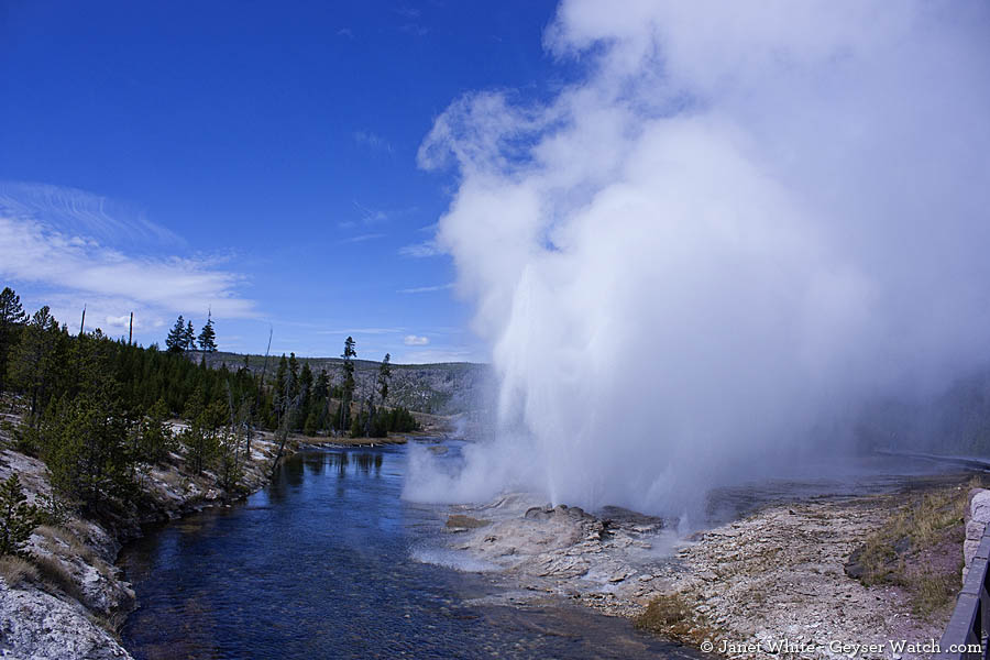
Fan and Mortar geysers in the Upper Geyser Basin of Yellowstone National Park fluctuate between active and dormant periods. (Janet White/Geyser Watch - click to enlarge)
By Janet White
Yellowstone geyser enthusiasts are reporting that a handful of Yellowstone National Park geysers appear to be active again after periods of dormancy, including one geyser that last erupted almost two decades ago.
http://www.yellowstonegate.com/2012/06/dormantyellowstone-geysers-a...
-
Comment by Recall 15 on April 9, 2012 at 7:53am
-
More on #38
April 9, 2012
Secretaría de Medio Ambiente y Recursos Naturales (Semarnat) confirm that 13,000 square m /42650.92 square ft of Los Frailes Beach sinks 140m/459.32 ft deep in Baja California South, Mexico after a loud sound. Sermanat warns that it is serious not only for the disappearance of the beach, but when entering the sea walking on the beach-just-five-steps it presents a cliff over 140 meters deep. Los Frailes Beach was closed to the Public by Proteccion Civil.
From:
SEARCH PS Ning or Zetatalk
Nancy Lieder, Emissary of the Zetas.
https://poleshift.ning.com/xn/detail/3863141:Comment:1168188
Awakening to the Alien Presence ZetaTalk
The truth will likely never to be known to the public but be washed away in the Nibiru panic soon to engulf the world.
The Worst of the Cover-Up
https://poleshift.ning.com/profiles/blogs/the-worst-of-the-cover-up
Main Establishment Lies
https://poleshift.ning.com/profiles/blogs/main-establishment-lies
Donate
© 2025 Created by 0nin2migqvl32.
Powered by
![]()
You need to be a member of Earth Changes and the Pole Shift to add comments!
Join Earth Changes and the Pole Shift