Please Place Evidence of the 7 of 10 Plate Movements Here
Kojima had created small snips of Konstantin's animation of the 7 of 10 Plate Movements.
Here is the full 7 of 10 Animation by Konstantin.
This blog is the place to document ongoing earth changes related to the 7 of 10 plate movements as described by the Zetas.
ZetaTalk: 7 of 10 Sequence
written October 16, 2010
The 7 of 10 scenarios describe plate movements, and for this to occur something has to release the deadlock, the current stalemate where the plates are locked against each other. Once the deadlock is broken and the plates start moving, sliding past each other, new points where the plates are locked against each other develop, but these are weaker locks than the one at present. The current lock, as we have so often stated, is the Indo-Australian Plate which is being driven under the Himalayans. This is no small lock, as the height of the Himalayans attests. Nevertheless, the activity in this region shows this likely to be the first of the 7 of 10 scenarios to manifest. Bangladesh is sinking and the Coral Sea is rising, showing the overall tipping of the Indo-Australian Plate. Now Pakistan is sinking and not draining its floods as it should, while Jakarta on the tongue of Indonesia is also sinking rapidly, showing that the tilt that will allow Indonesia to sink has already started.
Meanwhile, S America is showing signs of a roll to the west. Explosions on islands just to the north of the S American Plate occurred recently, on Bonaire and Trinidad-Tobago, and the Andes are regularly being pummeled. There is a relationship. As the Indo-Australia Plate lifts and slides, this allows the Pacific plates to shift west, which allows S America to shift west also. This is greatly increased by the folding of the Mariana Trench and the Philippine Plate. But it is the Indo-Australian Plate that gives way to incite change in these other plates, and this is what is manifesting now to those closely following the changes. Once the folding of the Pacific has occurred, Japan has been destabilized. We are not allowed to give a time frame for any of these plate movements, but would point out that it is not until the North Island of Japan experiences its strong quakes that a tsunami causing sloshing near Victoria occurs. There are clues that the New Madrid will be next.
Where the N American continent is under great stress, it has not slipped because it is held in place on both sides. The Pacific side holds due to subduction friction along the San Andreas, and the Atlantic side holds due to the Atlantic Rift's reluctance to rip open. What changes this dynamic? When S America rolls, almost in step with the folding Pacific, it tears the Atlantic Rift on the southern side. This allows Africa freedom to move and it rolls too, dropping the Mediterranean floor above Algeria. What is holding the N American continent together has thus eased, so that when the Japan adjustments are made, there is less holding the N American continent in place than before, and the New Madrid gives way. We are also not allowed to provide the time frame between the Japan quakes and New Madrid. Other than the relationship in time between the New Madrid and the European tsunami, no time frame can be given. The sequence of events is, thus:
- a tipping Indo-Australia Plate with Indonesia sinking,
- a folding Pacific allowing S America to roll,
- a tearing of the south Atlantic Rift allowing Africa to roll and the floor of the Mediterranean to drop,
- great quakes in Japan followed by the New Madrid adjustment,
- which is followed almost instantly by the tearing of the north Atlantic Rift with consequent European tsunami.
Source: http://www.zetatalk.com/index/zeta584.htm
Tipping Indo-Australia Plate with Indonesia sinking,
http://zetatalk.com/7of10/7of10-23.htm
http://zetatalk.com/7of10/7of10-24.htm
http://zetatalk.com/7of10/7of10-25.htm
http://zetatalk.com/7of10/7of10-26.htm
http://zetatalk.com/7of10/7of10-28.htm
http://zetatalk.com/7of10/7of10-30.htm
http://zetatalk.com/7of10/7of10-31.htm
http://zetatalk.com/7of10/7of10-32.htm
http://zetatalk.com/7of10/7of10-34.htm
http://zetatalk.com/7of10/7of10-37.htm
Folding Pacific
http://zetatalk.com/7of10/7of10-33.htm
http://zetatalk.com/7of10/7of10-38.htm
http://www.zetatalk.com/info/tinfx351.htm
http://zetatalk.com/7of10/7of10-47.htm
South American Roll
http://zetatalk.com/7of10/7of10-39.htm
http://zetatalk.com/7of10/7of10-40.htm
http://zetatalk.com/7of10/7of10-41.htm
http://zetatalk.com/7of10/7of10-42.htm
http://zetatalk.com/7of10/7of10-43.htm
http://zetatalk.com/7of10/7of10-44.htm
http://zetatalk.com/7of10/7of10-45.htm
http://zetatalk.com/7of10/7of10-47.htm
African Roll
http://www.zetatalk.com/7of10/7of10-46.htm
http://zetatalk.com/7of10/7of10-47.htm
http://zetatalk.com/7of10/7of10-48.htm
http://zetatalk.com/7of10/7of10-52.htm
Japan Quakes
http://www.zetatalk.com/7of10/7of10-53.htm
http://zetatalk.com/7of10/7of10-54.htm
New Madrid
http://www.zetatalk.com/7of10/7of10-59.htm
http://www.zetatalk.com/7of10/7of10-60.htm
http://zetatalk.com/7of10/7of10-61.htm
http://www.zetatalk.com/7of10/7of10-62.htm
http://zetatalk.com/7of10/7of10-63.htm
http://zetatalk.com/7of10/7of10-64.htm
http://zetatalk.com/7of10/7of10-65.htm
http://zetatalk.com/7of10/7of10-68.htm
European Tsunami
http://zetatalk.com/7of10/7of10-70.htm
http://zetatalk.com/7of10/7of10-71.htm
http://zetatalk.com/7of10/7of10-72.htm
http://zetatalk.com/7of10/7of10-73.htm
http://zetatalk.com/7of10/7of10-74.htm
Due to the slowing of the 7 of 10 plate movements by the Council of Worlds the impact of some of the events described above will be lessened.
The Zetas explain:
ZetaTalk: Pace Slowed
Written May 19, 2012
The effect of the thousands of humming boxes placed along fault lines and plate borders can be seen in several incidents that have occurred since the start of the 7 of 10 plate movements. The lack of tsunami during the 7 of 10 sinking of the Sunda Plate is one such example. We predicted at the start of the 7 of 10 scenarios in late 2010 that the Sunda Plate sinking would occur within 2-3 weeks, yet it dragged on through 2011. At the time we had predicted tsunami on the Sunda Plate, in general equivalent in height to the loss of elevation for a coastline. None of this occurred due to the slower pace.
The pace of mountain building in S America, where slowed, has still resulted in rumpling up and down the Andes, and stretch zone accidents likewise in lands to the east of the Andes. The shape of S America has clearly changed. Will the islands in the Caribbean be spared? At some point, as with the magnitude 7.9 quake in Acapulco on March 2, 2012 a significant adjustment will need to occur, and this will include depressing the Caribbean Plate so it tilts, sinking the islands and lands on that portion of the plate to the degree predicted. But the S American roll will likely continue to avoid the magnitude 8 quakes we originally predicted in deference to slow rumpling mountain building. The African roll was anticipated to be a silent roll in any case, so the slowed pace would not affect the outcome.
Will the slowed pace prevent the 7 of 10 scenarios for the Northern Hemisphere? Bowing of the N American continent has reached the point of pain, with breaking rock booming from coast to coast, but still there have been no significant quakes in the New Madrid area. Yet this is past due, and cannot be held back indefinitely. What has and will continue to occur for the Northern Hemisphere scenarios are silent quakes for Japan, which has already experienced drastic subduction under the north island of Hokkaido where mountain building is occurring as a rumple rather than a jolt. However, the anticipated New Madrid adjustment cannot be achieved without trauma. But this could potentially occur in steps and stages such that any European tsunami would be significantly lessened.
All rights reserved: ZetaTalk@ZetaTalk.com
Source: http://www.zetatalk.com/7of10/7of10109.htm
ZetaTalk , Written March 10, 2012
What happens when the pace of plate movement is slowed? The likelihood of tsunami is definitely reduced, as can be seen in the sinking on the Sunda Plate. The sinking occurred, and is almost complete, yet the possibility of tsunami we predicted for various regions on the Sunda Plate were avoided. The height and force of a tsunami is directly related to the degree of displacement in the sea floor, and if this happens in steps rather than all at once the displacement will be less for any given step.
This bodes well for the European tsunami. If the Council of Worlds is still imposing a slower pace on the 7 of 10 plate movements, this tsunami will definitely be lessened. The tear in the North Atlantic will be slight, each time. The amount of water pouring into this void will be less, each time. And the rebound toward the UK will likewise be less, each time. But our prediction is the worst case situation, and it also reflects what the Earth changes, unabated, would produce.
But what does a slower pace do to land masses where jolting quakes are expected? Does this reduce the overall magnitude of the quakes anticipated? Large magnitude quakes result when a catch point along plate borders is highly resistant, but snapping of rock finally results. Usually there is one place, the epicenter, where this catch point resides and a long distance along the plate border where smaller quakes have prepared the border for easy movement. A point of resistance within the body of a plate, such as the New Madrid, can likewise resist and suddenly give.
There is no way to lessen the resistance at these catch points, though the tension that accompanies such points can be reduced so that the quake itself is delayed. What this means for a slower 7 of 10 pace is that large magnitude quakes will be spread apart in time, and their relationship to our predictions thus able to be camouflaged by the establishment. Where sinking (such as the Caribbean Island of Trinidad) or spreading apart (such as to the west of the Mississippi River) are to occur, these land changes will eventually arrive. But like the sinking of the Sunda Plate, a slower pace unfortunately allows the cover-up time to maneuver and develop excuses.
All rights reserved: ZetaTalk@ZetaTalk.com
Comment
-
Comment by Howard on January 14, 2017 at 4:16am
-
Massive Land Fissure Opens in South Africa (Jan 12)
A massive crack in the land opened in the Northern Cape along the R31 between Daniëlskuil and Kuruman on January 12.
As a result, the R31 has permanently been closed, according to Arrive Alive.
Sources
http://www.enca.com/south-africa/watch-massive-sinkhole-in-northern...
http://citizen.co.za/news/news-national/1396381/watch-gigantic-sink...
-
Comment by Stanislav on January 4, 2017 at 7:44pm
-
Nigerian seismologists are all agreed that Nigeria is no longer an earthquake-free zone (aseismic)
as previously believed following the series of earth tremors in different parts of the country in recent times. This development requires that measures be put in place to mitigate the devastating effects when a major earthquake occurs in Nigeria. In this report, Vanguard Features presents the solutions as proffered by experts.4 January, 2017. Increasing seismic activities You may not have come to terms with its threatening reality. But some experts are convinced that there is a real possibility of an earthquake occurring somewhere within our shores. It all began with Mr. Umar Afegbua of the Centre for Geodesy and Geodynamics, National Space Research and Development Agency. According to him: “The recent trend of earthquakes/tremors in Nigeria is an indication that seismic activities within the country are increasing and urgent measures need to be adopted to avert devastating consequences of big earthquakes in the most populous black nation in the world.
The seismic events whose vibrations were felt heavily close to epicenters at the respective communities are now causing the entire country and indeed, the global seismological community a great concern” .
Professor Alexander Lar of the Department of Geology, University of Jos took it up from there. “Geologically, Nigeria is located in a so-called stable Pre-Cambrain–Paleozoic age Basement terrain believed to be seismically safe.
However, records have shown that earth tremors (minor earthquakes) have occurred in Nigeria from 1933-2016. An overview of these events would leave us with no other explanation than to question the previous assertion that Nigeria is seismically safe,” he submitted.Timeline: Nigeria experienced tremor in 1933, 1939, 1964, 1984, 1985 (in Komba Yaya), 1987 (in Akko) near Gombe; 1990, 1994, 1997, 2000, 2006, 2009 and 2016. Most of these occurrences were not instrumentally recorded because there were no functional seismological observatories in Nigeria but those of 1984 at Ijebu-Ode, 1990 at Ibadan and 2000 at Jushi Kwari were recorded.
South-West as epicentre “Earth tremors with different magnitudes and intensities have been observed or instrumentally recorded in Nigeria over the past 70 years. The epicenters of most of these events were mainly located in South-West Nigeria. However, no loss of lives or noticeable damages to property was recorded until recently in 2016,” said Afegbua. In their publication inwww.researchgate.net/publication/227304964_A_review_of_earthquake occurrences_and_observations_ n_Nigeria, Ajakaiye et al. 1988; Akpan, Yakubu 2010; Tsalha et al. 2015 noted that “the most frequent earthquakes were observed in the South-West of Nigeria, near Warri, Lagos, Ibadan and Akure. There are also records of earthquakes in Upper Benue Trough near Gombe, as well as Yola (in 1984 and 2005).”
“In 2016 alone, series of events with scary shakings were observed in Shaki community of Oyo State. Although the tremors were not recorded by the closest seismic station located in Ile-Ife, however, from the field observation and well-structured questionnaires data gathered by a team of experts from the Centre for Geodesy and Geodynamics under the National Space Research and Development Agency, NASRDA, the intensity of the tremors was established to range from three to four on the Modified Mercalli, MM, Intensity Scale, and the magnitudes subsequently estimated from the Ritcher Intensity-Magnitude Scale table,” stated Afegbua.
Bayelsa/Rivers: She continued: “While residents in the ancient community of Shaki were trying to come to terms with the tremors some residents described as strange and mysterious, the border communities of Bayelsa and Rivers states were hit with yet another tremor on July 10, 2016, and structures were seriously damaged in this case, but no loss of lives.
The tremors were widely felt within Bayelsa and Rivers states and this has changed the age-long belief that Nigeria is not active or free from earthquakes; and consequently, paving way for a new thinking and new focus on occurrence of earth tremors in the most populous Black nation. “Swiftly tailing the Bayelsa/Rivers states’ slip-up, were the Kaduna earthquakes, especially those that were witnessed at Kwoi and surrounding villages of Nok, Sanbang Daji and Chori, all in Jaba Local Government Area of Kaduna State on Sunday, 11th and Monday, 12th September, 2016. Damages to structures were noticed in the affected communities. The earthquakes at Kwoi were recorded by the seismic station at Kujama, Kaduna State and also operated by the Centre for Geodesy and Geodynamics, with magnitudes ranging from 2.6 to 3.0.”
Earthquake-causing faults: Earthquakes are said to occur along tectonic boundaries, faults, etc, as a result of sudden release of energy from strain failure. “Studies in Nigeria have suggested and in some cases, confirmed the existence of earthquake-causing faults within the country. Whether these intra faults are active or not, is a big question yet to be answered,” said Afegbua.
Source: vanguardngr.com
-
Comment by Kojima on December 21, 2016 at 3:36am
-
http://rev.seis.sc.edu/index.html
Attention REV and USArrayMonitor Users:
Due to major facilities maintenance on our building, REV and USArrayMonitor will be down for the next few weeks.
As these websites are quite old, it is possible that they will not be restarted after the facilities project is complete. We will confirm their status in the new year.
-
Comment by Stanislav on October 22, 2016 at 6:47pm
-
7 of 10 ZetaTalk accuracy. GNSS/GPS CORS show Southeastern US sinking and New Madrid strike-slip fault.
GNSS/GPS permanent stations for geodesy geodesy.unr.edu; data. Velocity (rates) in mm (millimeter) / year
GPS data:
Blewitt, G., C. Kreemer, W.C. Hammond, J. Gazeaux, 2016, MIDAS robust trend estimator for accurate GPS station velocities without step detection, accepted for publication in the Journal of Geophysical Research, doi: 10.1002/2015JB012552. geodesy.unr.edu; data
Important note on GPS (GNSS CORS) stations:
1) GPS stations measure changes only "point" and not on the area so that the rate of sinking or uplift should be used with cautiously. (as example see Houston-Gavelston area which already lose around 3 metres elevation) These maps should be used to see the trend! It's only around 6000 points on North America continent!
2) Many stations are relatively new and difficult to see the trend
3) 5 year minimum observation ( ... - 2016)
- Florida sinking
- Atlantic coast sinking
- Gulf of Mexico sinking
- New England uplift
- Great Lakes area sinking (stretching)
East Coast, US Continental rip, which is what occurs during pole shifts rather than continental drift, occurs down the length of the Atlantic Ocean. Prior to the rip, there is tension and consequent dragging down of the coast line on either side.
The East Coast of the US south of the New England area will suffer during the pole shift, due to this general stretching that the plates under the Atlantic during the crustal tension ahead of the shift. With the crust resisting a ripping apart so that the land on the edges of the Atlantic Ocean are pulled down.
This is most intense the closer one gets to the equator. This will bring the islands in the British Isles underwater, and along the southeastern US too for an astonishing drop in level beyond what the inhabitant think possible.
The New England states will find themselves bouncing up during the shift, due to the quick ripping of the already separating St. Lawrence Seaway prior to the shift, where the southern states will find themselves pulled under the water prior to the shift. The entire peninsula from central Pennsylvania north, will experience a bounce, but being on the edge of this drama, Pennsylvania will have its toes in water but its head above water.
Where tidal waves elsewhere will in general have the potential of rolling a hundred miles inland to a height of 200 feet or more within that buffer zone, for the East Coast south of the New England area, this must be calculated to be up to 500 miles inland where flat land or tidal bore has facilitated water flow. The land will drop in sea level, during the shift, 150 feet.
The water will rise steadily, not in a tidal wave, so that it will take many by surprise. This tension, and dragging down, will not be relieved until the shift itself, so where land might eventually be above water, prior to the sift it will be under water. Thus, the majority of the populace not well into the Appalachian mountains will drown.ZetaTalk: THE STRETCH ZONE, THAT SINKING FEELING
Severe flooding in Louisiana. Associated USA flood around Gulf of Mexico with 7 of 10? I do not know why but I think it is a loss of height. [and from another] http://www.disasternews.net/news/article.php?articleid=4510 Flood waters submerged parts of southern Louisiana Tuesday after heavy rains caused flash flooding and forced hundreds of rescues. The National Weather Service estimated 12 to 18 inches of rain fell across the region, with totals reaching up to 20 inches in some areas. Among the hardest hit areas in Lafayette Parish was Carencro, where reports indicated water was as high as high as 8 feet on some roads.
Just as the bowing in the S American Plate has produced stretching and consequent sinking in the swath of land from Rio to Buenos Aires, the bowing in the N American Plate has produced stretching and consequent sinking along the eastern seaboard and land bordering the Gulf of Mexico. Stretched land has only so many options. It can rip open to form a crevasse or a landslide or a sinkhole, or rock layers can pull apart so that train rails zip and zag and cause derailments and bridges pull from their moorings. In this case there is an adjustment in certain places, a pulling apart, which relieves the stress.
Stretched land also almost invariably drops in elevation, because the crust is thinned. This may not be apparent on the surface if the rock layers are pulling apart deep underground or under a river bed. But the underlying rock cannot spread out and thin without some evidence of this process above. For Florida, this evidence is the increasing number of sinkholes swallowing houses. Lopsided buildings, drooping roadways, and swamps extending their borders are other such symptoms. Drainage is invariably affected, as water lingers where it formerly drained. Rains and tides thus confuse the issue, with high tides blamed for much flooding, when sinking due to stretching is the cause.
ZetaTalk Chat Q&A for March 17, 2012
GPS data:
Blewitt, G., C. Kreemer, W.C. Hammond, J. Gazeaux, 2016, MIDAS robust trend estimator for accurate GPS station velocities without step detection, accepted for publication in the Journal of Geophysical Research, doi: 10.1002/2015JB012552. geodesy.unr.edu; data
7 Dead, Dozens Injured In I-35W Bridge Collapse [Aug 2] Interstate 35W bridge spanning the Mississippi River in Minneapolis collapsed, sending cars, people and debris into the river below. The collapse was likely structural in nature. It was not an act of terrorism. The bridge was undergoing repair work when it collapsed. Of the eight lanes on the roadway, four were closed for repair to the 40-year-old bridge's deck, joints, guardrails and lights. None of it would be related to the structure. The bridge was inspected by the Minnesota Department of Transportation in 2005 and 2006 and that no structural problems were noted. [and from another] Bridge Collapse Probe Focuses on Unexplained Shift [Aug 3]http://www.cnn.com/2007/US/08/03/bridge.structure/ Investigators trying to figure out what caused Wednesday's massive bridge collapse are focusing on the southern end of the span. The NTSB says one part of the bridge shifted 50 feet as it fell, while other sections collapsed in place. What's getting investigators' attention is the way the southern part of the bridge fell in a video they've already examined -- recorded by a security camera near the bridge's north end -- and the way the section settled after the collapse. It appears that it has shifted approximately 50 feet to the east and when we compare that to what we've seen in the rest of the bridge -- the rest of the bridge appears to have collapsed in place. [and from another] I live in a suburb of Minneapolis and nothing has ever happened like this before. There were reports in the news of a 'rotten egg smell' and an outbreak of of algae just a few days prior to this. I also felt, or heard, a strange frequency a couple of hours before this happened. [and from another] VIDEO: YouTube at Moment of Collapse http://www.youtube.com/watch?v=osocGiofdvc
We have predicted that bridges crossing the Mississippi will be affected when the New Madrid and related fault lines adjust, going into the pole shift. Was this bridge collapse which crossed the Mississippi in Minnesota caused by such an adjustment, the footings on one side of the bridge moving in an opposite direction from the footings on the other side, or perhaps the bridge being pulled apart? The Mississippi River is born in Minnesota, tumbling out of the headwaters in the highlands of Minnesota over a series of natural falls. This is a clue that adjustments in the rock strata could be involved. The highlands of Minnesota come to a point at Minneapolis, with lower land lying to the East along this point. What caused the land to the East to drop, unless this land was stretched in the past?
We have stated that the ripping apart of the St. Lawrence Seaway ends in the rumpled Black Hills of SD. Run a line from Montreal, at the mouth of the seaway, to Rapid City, SD and the line runs through Minneapolis. Why would an adjustment be made in the middle of this stretch zone while the seaway itself did not part? When we described the diagonal pull the N American continent is enduring, and just how this will snap when adjustments are made, we did not intend that this process would occur smoothly, all at once as described. Weak points along the rip lines give way one by one, each such adjustment placing stress on other points in a domino manner. The I35W bridge, being the larger of the bridges crossing the Mississippi at this point, was less able to adapt to a change in position vis-a-vis its footings on either side of the river, as it was an interstate bridge supporting several lanes, and thus had massive and thus rigid supports. Smaller bridges have more flexibility as they are built to withstand uneven loads on either end, thus are more springy by design.
Will there be more such disasters along the Mississippi and in the cities that will be affected by the New Madrid and seaway rip? This is just the start, and when the pace picks up, there will be no question that something other than Global Warming is the cause.
ZetaTalk: Minneapolis Bridge written Aug 2, 2007
GPS data:
Blewitt, G., C. Kreemer, W.C. Hammond, J. Gazeaux, 2016, MIDAS robust trend estimator for accurate GPS station velocities without step detection, accepted for publication in the Journal of Geophysical Research, doi: 10.1002/2015JB012552. geodesy.unr.edu; data
- Florida sinking
- Atlantic coast sinking
- Gulf Coast sinking
- Great lakes area sinking (stretching)
- New Madrid stress accumulation
- New Englanf uplift
Data faults: earthquake.usgs.gov; ceus-ssc.com
The ZetaTalk Newsletter Issue 76, Sunday May 4, 2008
GPS data:
Blewitt, G., C. Kreemer, W.C. Hammond, J. Gazeaux, 2016, MIDAS robust trend estimator for accurate GPS station velocities without step detection, accepted for publication in the Journal of Geophysical Research, doi: 10.1002/2015JB012552. geodesy.unr.edu; data
What are the areas affected the most, by being in the stretch zone, during the pole shift?
- Florida
- Stretching out into the ocean, Florida has a tenuous position during the coming cataclysms. The strikes against it are many. The land is too low to offer safe haven to tidal waves, which will roll over the state without hindrance, from one side to the other.
When the Atlantic stretches, just prior to the shift, the lands closest to the equator will feel the draw the most, as this is where the Atlantic rifts are deepest. Thus, where land in the southeastern US will be pulled under to the degree that water may lap at cities high in the Appalachian mountains, along the eastern seaboard, it will surely pull Florida under the water long enough to drown the populace totally.
Those in boats will find they must contend with whirlpools and sloshing water that can capsize even large ocean going vessels. And those in skyscrapers likewise should not assume that their foundations will not be undercut and eroded. This is not a safe place. - Georgia
- Low lying lands along the eastern coast of the United States will be drawn below sea level some 150 feet at the start of the pole shift, water rushing in over land pulled down temporarily by the stretch that the sea floor of the Atlantic will experience.
This in combination with the tidal waves that all ocean coasts can expect will wreak havoc on states such as Georgia. Where Georgia has land in it's headlands that border the Appalachian Mountains, the steady rise of land from coast to foothills will actually encourage the water to rise higher, as it will gain momentum.
Those living in the low lands of Georgia will in all likelihood drown, unless in boats that can deal with wildly sloshing water. Following the shift, these low lands will also steadily go under water due to the melting poles. Those wishing to survive are advised to move. - Atlanta
- Southern cities on the East Coast, such as Atlanta, Georgia, at an 800 foot above sea level height, will watch a flood approach. This is due in part to the timing of the stretch and rip, as the stretch will be sustained for the better part of an hour during a time when water will rush from the poles, where it has moved during the stopped rotation, and will have the push of on-coming water behind it as it flows up against the coastline. Atlanta, stationed between the Gulf and the Atlantic, will also find itself at a place where two floods, both with their own timing of ebb and flow, clash. This has the potential of heightening the water, forcing it up to an astonishing degree, where the clash occurs.
- South Carolina
- As with all area along the Eastern Seaboard, south of New York City, elevation will not save them from a dunking unless they are close to 1,000 feet in elevation and several hundred miles from the coast. The coastline will be pulled down several hundred feet just prior to continental rip, which will rent the deep Atlantic Ocean rifts further apart.
The permanent effect on the coastline along the southern portion of the US will be a drop of 150 feet, below its former level. For residents unprepared for this, the rise is sea level will be steady, not a wave as in a tidal wave, and will be completely confusing to those unaware of the coming changes.
The water will simply rise up to their feet and then over their heads, steadily. Those in the foothills of the Appalachian Mountains may find their toes only wet, but for safety, go to higher ground and return home after the shift. - New Jersey
- All areas along the Eastern Coast will have to deal with tidal waves as a fact they cannot discount, during the coming pole shift. No wall will be strong enough to resist the weight of water that will rise up, 100 feet high, in a steady flood tide, nor are there walls in place today constructed with that in mind. High rise buildings with doors and windows and sewage connections will do more than flood, on the lower floors, they will crush and drop, as the water will create uneven pressure on outside walls, pressure they were never expected to have to resist. New Jersey does not have the elevation or distance from the coast to assure safety.
- Montreal, Canada
- Because the tearing of the St. Lawrence seaway will begin as soon as the stretching of the Atlantic occurs, land along this seaway will not submerge nor will any noticeable influx of ocean water occur, as the influx will be filling the new river bed area, now to become more of a lake. The tear will occur principally where the St. Lawrence seaway now runs, as this is a low point only because of the existing tear. Weak spots are deep within the rock strata under the river bed, and the tearing is less of a deep rift than a pulling apart in many places, so the surface seems relatively smooth. Beneath this tear are many feathery fingers of rock, reaching toward each other, soon filled with hardened magma to solidify. Thus, even though Montreal is surrounded by water, it will simply find itself more of an island than another Atlantis.
- Niagara Falls
- Niagara Falls will split during the widening of the St. Lawrence Seaway, as will all natural and manmade barriers between the Great Lakes and the Atlantic. This will change the level of the lakes, and the drainage patterns, to some degree, depending upon the level of bordering land and the ocean tides. Salt water will be detected all the way up to Lake Michigan and Lake Superior, which will appear to be the fresh water lakes they are now. Niagara Falls appears dramatic only because the water way spills suddenly, rather than gradually, and being shattered and spread during the widening of the seaway, the falls will become merely rock walls along the new course of the waterway. Thus, the great seaway will become a mode of travel, and cities along this course such as Buffalo and Hamilton can anticipate being travel stops and point of commerce among survivors.
- Ottawa
- The Ottawa River will swell during the pole shift, and not return to it's former size. During the stretching of the Atlantic that occurs during the pole shift, and consequent widening of the St. Lawrence Seaway, Ottawa will also be stretched, with the result that the Ottawa River will become ocean, saltwater, and the two halves of Ottawa separated. Where this will not be the case in the northern region, this will go under water shortly so the separation by water will seem complete. The land close to Ottawa, the city, will ride high, and be relatively secure from the havoc from earthquakes and volcanoes that rack some other parts of the world along fault lines. Plan on fishing as a source of food, in the main, during the Aftertime.
ZetaTalk blog: THE STRETCH ZONE, THAT SINKING FEELING
GPS data:
Blewitt, G., C. Kreemer, W.C. Hammond, J. Gazeaux, 2016, MIDAS robust trend estimator for accurate GPS station velocities without step detection, accepted for publication in the Journal of Geophysical Research, doi: 10.1002/2015JB012552. geodesy.unr.edu; data
Blewitt, G., C. Kreemer, W.C. Hammond, J. Gazeaux, 2016, MIDAS robust trend estimator for accurate GPS station velocities without step detection, accepted for publication in the Journal of Geophysical Research, doi: 10.1002/2015JB012552. geodesy.unr.edu; data
ZetaTalk:
- Northern California uplift
- From San Diego to Moneterey uplift
- Sierra Nevada uplift
- West US summary uplift
- Great Basin some uplift
- Vancouver Island uplift (below image)
The San Andreas Fault line runs up through California and thence out into the Pacific. This is a slip-slide zone through California, so that mountain building occurs on both sides of the San Andreas Fault. Why would this be so, when the Pacific compresses greatly? There are points out in the Pacific, which is not one plate but at least four, that give more readily, thus sparing California from immediate subduction trauma. Yet the plates pushing under the West Coast of N America do cause mountain building all the way to the Continental Divide. How can this seeming contradiction exist? Plates are composed of layers of rock, a fact to which we have often alluded. These layers can pull apart to create a thinner crust in those parts of the globe that are in the stretch zone, thus causing those regions to drop in elevation, to sag.
Where the various rock layers find they meet a barrier, but some of the rock layers (perhaps the surface layers) have more resistance than the deeper layers, sliding of these layers can occur. This is a deep adjustment within the plate, which like a stack of papers finds it is still just as thick, though parts of the stack have shifted to this or that side. This is occurring in California. The top layers of the Pacific Plate pushing under the West Coast scrape off and rumple, creating the coastal mountains while the deeper layers proceed to push under all the way to the Continental Divide. This process will continue to occur during the pole shift, and thus there will be rumpling along the coastal mountains from San Diego to Monterey, though this new rumpling will occur at a deep level and not likely toss those on the surface about. There will be an elevation increase of perhaps 57 feet for this region.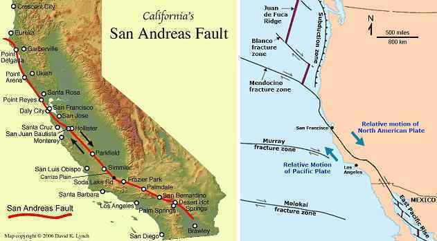
For northern California there is a similar rise in elevation but higher, perhaps to 92 feet. The San Francisco Bay area will notice this, as the rivers emptying into the Bay will become a waterfall at their joint outlet. However, as the oceans rise 675 feet within two years after the shift, this too will be covered in water. This rise in elevation does not continue beyond northern California, as the Juan de Fuca Plate absorbs any pressure from the push of the Pacific Plate. Thus the elevation rise for Oregon and Washington is not expected to be more than 25-30 feet. We have stated that Vancouver Island will get an increase of 100 feet and travel 100 miles further north from the Canadian coastline due to the fracturing of the Juan de Fuca and N American plates at this point. The tiny Explorer Plate is an indication of this. The San Andreas slip-slide will drag Vancouver Island along, and rumple this up to 100 feet above where it is today.
ZetaTalk ™ December 25, 2010
ZetaTalk Troubled times: San Andreas Slide
GPS data:
Blewitt, G., C. Kreemer, W.C. Hammond, J. Gazeaux, 2016, MIDAS robust trend estimator for accurate GPS station velocities without step detection, accepted for publication in the Journal of Geophysical Research, doi: 10.1002/2015JB012552. geodesy.unr.edu; data
GPS data:
Blewitt, G., C. Kreemer, W.C. Hammond, J. Gazeaux, 2016, MIDAS robust trend estimator for accurate GPS station velocities without step detection, accepted for publication in the Journal of Geophysical Research, doi: 10.1002/2015JB012552. geodesy.unr.edu; data
-
Comment by Stanislav on October 22, 2016 at 6:47pm
-
Horizontal GPS/GNSS velocity as of 2014
New Madrid strike-slip fault
Important horizontal GPS velocity notes:
A 'reference frame' is a point of view. If your reference frame is North America, you are standing on North America, seeing how other places move, from your point of view.
Plate Tectonics and GPS 'Reference Frames'
For example you might wonder how the Pacific plate is moving past North America, and use North America as the reference frame.
Plate Boundary Observatory (PBO) GPS derived data products for GPS station coordinates are available for two reference frames: the North American tectonic plate (NAM08) and a global reference frame (IGS08). NAM08 assumes that the interior eastern part of North America functions as a 'stable' rigid plate and deformation at the plate boundaries (particularly apparent that the western boundary) is shown in relation to the stable part of the plate. IGS08 is a 'no net rotation' reference frame. 'No net rotation' is the motion of each plate with respect to the weighted average of all of the world's plate velocities. It is sometimes referred to as absolute plate motion, since it appears to approximately represent the motions of the surface plates with respect to the Earth's deep interior. It closely resembles the apparent motion of the world's plates with respect to hot spot volcanoes. IGS08 is based on the International Terrestrial Reference Frame (ITRF).
The GEM Strain Rate Map Project provides a choice of several reference frames for their collection of thousands of velocity vectors from around the globe, and a 'no net rotation' reference frame.
Source: unavco.org
North America reference frame
Kreemer, C., G. Blewitt, E.C. Klein, 2014, A geodetic plate motion and Global Strain Rate Model, Geochemistry, Geophysics, Geosystems, 15, 3849-3889, doi:10.1002/2014GC005407. gsrm2.unavco.org
ZetaTalk:
- New England move to east
- Mexico move to west
- West US bow stress
North America reference frame
Kreemer, C., G. Blewitt, E.C. Klein, 2014, A geodetic plate motion and Global Strain Rate Model, Geochemistry, Geophysics, Geosystems, 15, 3849-3889, doi:10.1002/2014GC005407. gsrm2.unavco.org
ZetaTalk:
- Upper Midwest move to east
- Southwest move to west
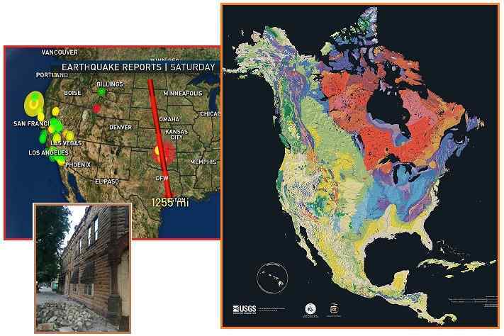
Clearly this deep quake was in preparation for adjustments along the New Madrid Fault Line, which will result in immense structural damage to mankind’s infrastructure. The Oklahoma quake adjustment was along rock strata that is more rigid than the soft rock that ripped, taking the path of least resistance by pulling apart soft rock throughout the midsection of the N American continent. Essentially, the upper Midwest moved somewhat further East, while the Southwest moved with Mexico to the West. This is the diagonal pull that the N American continent endures, which ultimately results in the New Madrid adjustment.
ZetaTalk Chat Q&A for September 10, 2016
North America reference frame
Kreemer, C., G. Blewitt, E.C. Klein, 2014, A geodetic plate motion and Global Strain Rate Model, Geochemistry, Geophysics, Geosystems, 15, 3849-3889, doi:10.1002/2014GC005407. gsrm2.unavco.org
North America reference frame
Kreemer, C., G. Blewitt, E.C. Klein, 2014, A geodetic plate motion and Global Strain Rate Model, Geochemistry, Geophysics, Geosystems, 15, 3849-3889, doi:10.1002/2014GC005407. gsrm2.unavco.org
Atlantic and Europe stretch. Mediterranean parts sinking
- Western England sinking
- Spain and Portugal sinking
- Morroco sinking
GPS data:
Blewitt, G., C. Kreemer, W.C. Hammond, J. Gazeaux, 2016, MIDAS robust trend estimator for accurate GPS station velocities without step detection, accepted for publication in the Journal of Geophysical Research, doi: 10.1002/2015JB012552. geodesy.unr.edu; data
GPS data:
Blewitt, G., C. Kreemer, W.C. Hammond, J. Gazeaux, 2016, MIDAS robust trend estimator for accurate GPS station velocities without step detection, accepted for publication in the Journal of Geophysical Research, doi: 10.1002/2015JB012552. geodesy.unr.edu; data
- Europe parts stretching
GPS data:
Blewitt, G., C. Kreemer, W.C. Hammond, J. Gazeaux, 2016, MIDAS robust trend estimator for accurate GPS station velocities without step detection, accepted for publication in the Journal of Geophysical Research, doi: 10.1002/2015JB012552. geodesy.unr.edu; data
GPS data:
Blewitt, G., C. Kreemer, W.C. Hammond, J. Gazeaux, 2016, MIDAS robust trend estimator for accurate GPS station velocities without step detection, accepted for publication in the Journal of Geophysical Research, doi:10.1002/2015JB012552. geodesy.unr.edu; data
We have stated that Africa is turning in place, its base at S Africa firmly nailed and unable to move, the top rolling to the East as the Atlantic yaws open. This action is what is causing the African Rift to spread so rapidly, in the Afar Triangle, where huge crevasses appear before astonished eyes and the land is dropping hundreds of feet. The Mediterranean will be destabilized. The African plate is a straight line across the top, and when it turns it will create a YAW in the Mediterranean, causing volcanoes in the area to become active as lava is exposed to the surface, and certainly destabilizing countries just to the north of the fault line dissecting the Mediterranean from East to West. The Mediterranean, in the past, was a swamp, but now is a sea. What caused the land to drop? The Black Sea participated in this drop, being inundated where formerly land above water. Istanbul lies at the center of the area that will first be affected when a serious roll of Africa occurs.
ZetaTalk: Phoenix Lights written Feb 10, 2007
ITRF08 Reference frame GPS data:
Kreemer, C., G. Blewitt, E.C. Klein, 2014, A geodetic plate motion and Global Strain Rate Model, Geochemistry, Geophysics, Geosystems, 15, 3849-3889, doi:10.1002/2014GC005407. gsrm2.unavco.org
UK - 68,5 cm move to Northeast since 1994. Source: geodesy.unr.edu
Iberian Peninsula - 52,3 cm move to Northeast since 1997. Source: geodesy.unr.edu
US - 17,7 cm move to Northwest since 2007 Source: geodesy.unr.edu
Kreemer, C., G. Blewitt, E.C. Klein, 2014, A geodetic plate motion and Global Strain Rate Model, Geochemistry, Geophysics, Geosystems, 15, 3849-3889, doi:10.1002/2014GC005407. gsrm2.unavco.org
Himalayan swirl
Yangtze reference frame (Yangtze Plate)
Kreemer, C., G. Blewitt, E.C. Klein, 2014, A geodetic plate motion and Global Strain Rate Model, Geochemistry, Geophysics, Geosystems, 15, 3849-3889, doi:10.1002/2014GC005407. gsrm2.unavco.org
Eurasian reference frame
Kreemer, C., G. Blewitt, E.C. Klein, 2014, A geodetic plate motion and Global Strain Rate Model, Geochemistry, Geophysics, Geosystems, 15, 3849-3889, doi:10.1002/2014GC005407. gsrm2.unavco.org
Eurasian reference frame
Kreemer, C., G. Blewitt, E.C. Klein, 2014, A geodetic plate motion and Global Strain Rate Model, Geochemistry, Geophysics, Geosystems, 15, 3849-3889, doi:10.1002/2014GC005407. gsrm2.unavco.org
Yangtze reference frame (Yangtze Plate)
Kreemer, C., G. Blewitt, E.C. Klein, 2014, A geodetic plate motion and Global Strain Rate Model, Geochemistry, Geophysics, Geosystems, 15, 3849-3889, doi:10.1002/2014GC005407. gsrm2.unavco.org
ZetaTalk:
- Himalayan swirl
The ZetaTalk Newsletter Issue 301, Sunday July 8, 2012
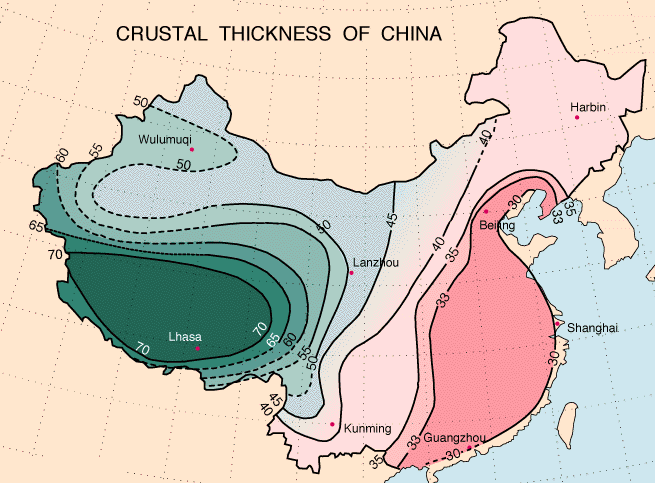
As noted in our explanation of the Hangzhou UFO sighting, which was seen from the airport at Hangzhou and down along the China coastline all the way to the Vietnam Sea, this coastline can anticipate participating in the 7 of 10 sinking of the plate tongue holding Indonesia. This is what is emerging. As we pointed out at that time, these regions were being warned about tsunami and a suddenly rising sea level as the plate tongue holding Indonesia is bent and pulled down. Note the path of the quakes you delineated, and they are along this path that was warned. This area of China is also subject to being bent, as the crust is not as thick as further inland, and as is known is having horrific sinkhole problems.
ZetaTalk Chat Q&A for January 22, 2011
GPS data:
Blewitt, G., C. Kreemer, W.C. Hammond, J. Gazeaux, 2016, MIDAS robust trend estimator for accurate GPS station velocities without step detection, accepted for publication in the Journal of Geophysical Research, doi: 10.1002/2015JB012552. geodesy.unr.edu; data
<...> Japan will experience an average of a 200 foot rise during the pole shift, but this will vary from the north end of the Japanese islands to the south. Japan lies on the N American continent, a tongue of which protrudes in that direction, encompassing the Aleutian Islands, Japan, and the Kamchatka region. We have stated that this tongue will not break off to become a separate plate, despite all pressure on it. That portion of the Japanese islands closer to the main plate, to the north, will remain further above the waves after the shift, due to rising with the main N American plate which will ride over the Pacific plates. Due to the crumbling of the Philippine Plate, the region near the southern part of the Japanese islands does not get pushed up as far, as that which would subduct under southern Japan finds an easier path through the crumble. Thus, northern Japan might find land rising 250 in elevation, while southern Japan experiences a 150 rise in elevation.
ZetaTalk Troubled Times: Japan
Africa twist
Kreemer, C., G. Blewitt, E.C. Klein, 2014, A geodetic plate motion and Global Strain Rate Model, Geochemistry, Geophysics, Geosystems, 15, 3849-3889, doi:10.1002/2014GC005407. gsrm2.unavco.org
Red sea expands
Kreemer, C., G. Blewitt, E.C. Klein, 2014, A geodetic plate motion and Global Strain Rate Model, Geochemistry, Geophysics, Geosystems, 15, 3849-3889, doi:10.1002/2014GC005407. gsrm2.unavco.org
Kreemer, C., G. Blewitt, E.C. Klein, 2014, A geodetic plate motion and Global Strain Rate Model, Geochemistry, Geophysics, Geosystems, 15, 3849-3889, doi:10.1002/2014GC005407. gsrm2.unavco.org
-
Comment by Stanislav on October 22, 2016 at 6:45pm
-
Some facts. ZetaTalk Accuracy.
US
The GPS/GNSS show massive continental scale sinking in US East Coast, Atlantic coast, Great lakes area and in many others parts in Western US. Also GPS/GNSS show massive uplift of parts West US, Vancouver island and New England.
Sierra Nevada uplift, from San Diego to Moneteray area uplift, Northern Calfornia uplift, Great Basin parts uplift and etc.
GPS/GNSS show New Madrid sesmic strain (strike-slip fault) upper Midwest (with New England to south-west) move to East and southwest move to west (with Mexico) also west area around Missisipi uplift while east area sinking.
Earthquakes increase in Arizona, Central California, Alaska, Missouri, Oklhaoma, Vrginia, Kansas, Ohio, Arkansasm Colorado, New Mexico, Texas
Certain areas of New Orleans have dropped 113cm [12] Parts of Harris County, Texas have dropped between 10 and 12 feet (3 metres) since the 1920s, according to data from the U.S. Geological Survey. [13] Central California sinking faster than ever [31]
India, Pakistan
India has already moved to Northeast (under Himalayas) around 1,2 metres since 1994 as show GPS/GNSS station [15] 45% of India's coastline facing erosion. [19] India'n deltas are sinking [22]
Cases of flooding with salt water (or so-called flood tide) in India are common, these are just a few examples: Sundarbans, Sagar Island [23] Mumbai [24] Machiwad village, Navsari [25] and etc. For Pakistan: in Badin floods salt water mixes with salt water [26] and etc. And many salt intrusion cases [27] [28] and etc
In Godavari delta some parts of the coastal area had sunk by 5 feet, at the rate of 3-4 inches per year and this sinking blamed for floods [29]
Atlantic expands
Pacific plate shrinks [20] while Atlantic expands -
UK - around 68,5 cm move to Northeast since 1994.
Iberian Peninsula - around 52,3 cm move to Northeast since 1997.
US - around 17,7 cm move to Northwest since 2007
Indonesia
North Jakarta has sunk four metres in the last 35 years. [1] Jakarta lose 0 - 2.6 metres since 1998 to 2014 [2]
In HUGE parts (suburbs, none-urban area and etc.) of Java and Sumatra show severe scale sinking 3 cm/year (InSAR 2006-2009 obervation) Also sinking detected in such cities Lhokseumawe, Medan, Jakarta, Bandung, Pekalongan, Semarang, Blanakan, Bungbulang, and in the Sidoarjo regency at rates up to 22 cm/yr (as example 5*22=110cm (for 5 years)). [6]
Mexico
In Mexico InSAR show 21 sinking areas, including 17 cities. Linear sinking rates of 30 cm/yr are observed in Mexico City, while in the other locations rates of 5-10 cm/yr are detected. [16] Mexico is already drop 32 feet (10 metres) elevation and also show 1 metres/year sinking rate [17]
Southeast Asia
Almost innumerable instances of flooding with seawater (or so-called flood tide). Some examples:
Bangkok [33] Singapore [34] Rakhine state, Myanmar [35] Malabon, Bulacan, Philippines [36] Ho Chi Minh City [37] Klang, Malaysia [38] and many etc.
Philippines
Manila already lose around 0.68 meter to 1.34 meters in 30 years (from 1979 to 2009) and continue 5.5 cm/y as show ENVISAT ASAR. [3]
Thailand
Bangkok lose around 100 cm from 1978 - 2011 [4] Parts of the Chao Phraya River delta have sunk 1.5 meters below sea level. [14]
Vietnam
Vietnam, Mekong delta parts sinking rates 2 cm/y with Ca Mau and No Chi Minh city higher than 4 cm/year [5]
North Vietnam, Bao Yen district (Lao Cai), Yen Bai city and Hai Hoa district (Yen Bai) the subsidence rate reached up to -60 mm/year. The author called the cause of subsidence fault slip (Red river Fault) [7] Parts of Hanoi also show around 40 mm/year subsidence rate [8]
Cau Mau subsided from 30 to 70 cm in many places [32]
Taiwan
Many areas in Taiwan already lose elevation - Taipei 2.11m, Yilan 0,48m in the north, Changhua 2,50m, Yunlin 2,47m, Chiayi 1,50m and Pingdong 3,40m in Central and Southern Taiwan. [9]
Bangladesh
GPS show sinking (see below picture)
Malaysia
GPS show sinking
China
Himalayan swirl also confrimed by GNSS/GPS (see below)
"Since the 1950s, constant land subsidence has occurred across nearly 70,000 square kilometers there, with some places sinking 3.18 meters and at an annual rate of more than 100 millimeters. Beijing, Tianjin, Tanggu and Cangzhou are the most affected areas – Cangzhou has sunk about 2.4 meters since the 1970s, said Wu Aimin of the Chinese Academy of Geological Environment Monitoring." [18]
"Shanghai has sunk by nearly 3 metres over the last 80 years, causing damage worth 14.5 billion yuan (US$1.7 billion), according to a report. The report also shows that 16 provinces and regions in China, and 46 major cities also suffer from subsidence.
The report shows that south of the Yangtze River, the land has sunk by an average of more than 20 centimetres over an area of almost 10,000 square kilometres. The most serious ground subsidence occurs in the urban districts of Shanghai Municipality and Suzhou, Wuxi and Changzhou in East China's Jiangsu Province, and Jiaxing in Zhejiang Province. Subsidence here can reach 2.63 metres." [21]Mediterranean and Europe
There are many cases of sea water floods (or so-called flood tide) examples:
Unsual tide floods in Msida, square, Malta [30] Isle of Man island unusually high tide flooded road [39] Channel Islands flooded after 'highest tide of the year' [40]
To see more details images, figure and etc see below
Confrimed facts
- Southeastern US sinking (GNSS/GPS CORS also many news sources, InSAR and etc )
- Great lakes stretching (sinking)
- Upper Midwest move to east with New England to south west. Southwest move to west with Mexico. While east coast remain stable (GNSS/GPS CORS)
- West US bow stress and uplift (some parts sinking) (GPS/GNSS CORS also many news sources, InSAR and etc)
- Arizona parts sinking due bow stress (InSAR)
- Spain parts, West England, Portugal, Morocco sinking (GNSS/GPS)
- Java and Sumatra HUGE parts sinking with 7 big cities (InSAR)
- Bangkok sinking (leveling)
- Metro Manila sinking and (InSAR)
- Bangladesh parts sinking (GNSS/GPS)
- India moving to Northeast around 1.2 metres (GNSS/GPS IGS08 Reference frame). Australia around 1.5 metres.
- Himalayan swirl (GNSS/GPS)
- Red sea expands (GNSS/GPS)
- Atlantic stretch - (GNSS/GPS IGS08 Reference frame) UK - around 68,5 cm move to Northeast since 1994. Iberian Peninsula - around 52,3 cm move to Northeast since 1997. US - around 17,7 cm move to Northwest since 2007
- Africa twist
References
[1] 1 May 2014. EGU2014: Land subsidence in coastal megacities outranges sea level rise Source: dutchwatersector.com
[2] Abidin, H. Z., Andreas, H., Gumilar, I., & Wibowo, I. R. R. (2015). On correlation between urban development, land subsidence and flooding phenomena in Jakarta. Proceedings of IAHS, 370, 15-20. proc-iahs.net
[3] 24 September, 2011. Large areas of Metro Manila sinking Source: opinion.inquirer.net
[4] 2 February, 2015. Caught between rising seas and subsidence, and hit by alternate droughts and floods, Bangkok is fighting for dry ground like never before Source: bangkokpost.com
[5] Erban, L. E., Gorelick, S. M., & Zebker, H. A. (2014). Groundwater extraction, land subsidence, and sea-level rise in the Mekong Delta, Vietnam. Environmental Research Letters, 9(8), 084010. iopscience.iop.org
[6] Chaussard, E., Amelung, F., Abidin, H., & Hong, S. H. (2013). Sinking cities in Indonesia: ALOS PALSAR detects rapid subsidence due to groundwater and gas extraction. Remote Sensing of Environment, 128, 150-161. rsmas.miami.edu
[7] Nguyen, Xuan Thi; Chang, Chung-Pai (2015) MAPPING SURFACE DEFORMATION IN RED RIVER FAULT ZONE USING SPACEBORNE SAR INTERFEROMETRY In Proceedings of the 36th Asian Conference on Remote Sensing (ACRS 2015), Manila, Philippines
[8] Le, S. T., & Chang, C. P. (2015, October). Surface deformation assessments in Hanoi, Vietnam using ALOS PALSAR interferometry. In Proceedings of the 36th Asian Conference on Remote Sensing (ACRS 2015), Manila, Philippines (pp. 19-23).
[9] Hsu, W. C., Chang, H. C., Chang, K. T., Lin, E. K., Liu, J. K., & Liou, Y. A. (2015). Observing Land Subsidence and Revealing the Factors That Influence It Using a Multi-Sensor Approach in Yunlin County, Taiwan. Remote Sensing, 7(6), 8202-8223. This is an open access article distributed under the Creative Commons Attribution License (CC BY 4.0).
[12] 10 August, 2016. Rising tides, sinking cities. Source: trtworld.com
[13] 28 May, 2016. For years, the Houston area has been losing ground. Source: houstonchronicle.com
[14] Deltas Sink Worldwide, Increasing Flood Risk. Source: worldwatch.org
[15] Nevada Geodetic Laboratory - station IISC
[16] Chaussard, E., Wdowinski, S., Cabral-Cano, E., & Amelung, F. (2014). Land subsidence in central Mexico detected by ALOS InSAR time-series. Remote sensing of environment, 140, 94-106. estellechaussard.com
[17] 5 March, 2016. Why This City of 21 Million People Is Sinking 3 Feet Every Year. Source: ecowatch.com
[18] 2 November, 2011. Sinking North China Plain threatens development. Source: china.org.cn
[19] Source: business-standard.com
[20] 27 August, 2014. Ring Of Fire Tectonic Plate Is Cooling - And Shrinking. Source: science20.com
[21] Source: in.china-embassy.org
[22] 9 April, 2014. India deltas are sinking Source: thehindu.com
[23] 26 August, 2014. Mystery tide floods Sagar Island. Source: timesofindia.indiatimes.com
[24] 30 December, 2015. High tide floods Mumbai, is city collapsing? Source: deccanchronicle.com
[25] 5 July, 2016. Seawater enters Machiwad village in Navsari. Source: nyoooz.com
[26] 6 September, 2011. Sindh floods: Salt water mixes with rain to add to Badin’s woes. Source: tribune.com.pk
[27] 10 January, 2015. Coastal villagers retreat as seas gobble land. Source: pakistantoday.com.pk
[28] 28 September, 2015. Arabian Sea eating up 100 acres of Sindh land daily. Source: geo.tv
[29] Land subsidence blamed for floods in Godavari. Source: archives.deccanchronicle.com
[30] 12 May, 2016. Unusual tide floods Msida square Source: timesofmalta.com
[31] 20 August, 2015. 2 inches a month: California sinking faster than ever, infrastructure in danger Source: rt.com
[32] 12 July, 2013. Land subsidence in Ca Mau Peninsula. Source: vietnambreakingnews.com
[33] 4 November, 2011. Flood water claims more areas of capital. Source: nationmultimedia.com
[34] 29 April, 2013 Flash floods hit eastern parts of S'pore. Source: news.asiaone.com
[35] 28 September, 2015. 4,000 Rakhine Rice Acres Unsuitable for Harvest This Season Source: mmbiztoday.com
[36] 24 January, 2013. High tide triggers Malabon, Bulacan floods Source: news.abs-cbn.com
[37] 5 December, 2013. Flood tide in HCM City hit record. Source: hanoitimes.com.vn
[38] 19 October, 2016. Homes damaged by floods, challenging times ahead for residents in Klang. Source: nst.com.my
[39] 3 January, 2014. Isle of Man roads closed by flooding after high tide Source: bbc.com
[40] 3 March, 2014. Channel Islands flooded after 'highest tide of the year' Source: bbc.com
-
Comment by Stanislav on October 22, 2016 at 6:44pm
-
West US Uplift
ZetaTalk: Mountain Building Note: written on May 15, 1999.
This time around, there will be strong mountain building, in particular in the Hymalayas and Andes, not so much along the West Coast of North American, and hardly at all in the Alps in Europe
California drought causes major tectonic uplift
Spatial distribution of ground displacements from March 1 of 2011 through 2014. Uplift is indicated by yellow-red colors and sinking by shades of blue. Gray regions show where stations were excluded in the Central Valley of California. Source: citylab.com
Vertical displacement data of GPS stations around the United States. The top image shows data for a year in which heavy precipitation occurred in the west (March 2011) and on the bottom during a drought year (March 2014).
Image Credit: Adrian Borsa, Scripps Institute of Oceanography, University of California San Diego. physicscentral.com
23 August, 2014. The lost water from the current severe drought has alleviated enough pressure from the crust to uplift land in California anywhere from 4 millimeters (.15 inch) to 15 millimeters (.6 inch) in the past few years.
Although clearly visible in before and after photographs, the water loss due to the drought in California can now be measured tangibly: the amount of water loss has been so great that the Earth’s crust is rising rapidly across the region.
According to the calculations of scientists from the Scripps Institution of Oceanography at the University of San Diego, the water deficit during the drought is currently 240 gigatons, or 63 trillion gallons. The lost water weight alleviated enough pressure from the crust to uplift land in California anywhere from 4 millimeters (.15 inch) to 15 millimeters (.6 inch) in the past few years.
<...> Though significant changes to the crust may alarm residents in an area with high plate tectonic activity already, the scientists stress that the uplifting has virtually no impact on the San Andreas fault and should not correlate with any increased seismic activity. Source: natmonitor.com
Source: slideplayer.com
California Central Valley groundwater depletion slowly raises Sierra Nevada mountains
14 May, 2014. Winter rains and summer groundwater pumping in California's Central Valley make the Sierra Nevada and Coast Mountain Ranges sink and rise by a few millimeters each year, creating stress on the state's faults that could increase the risk of an earthquake.
Gradual depletion of the Central Valley aquifer, because of groundwater pumping, also raises these mountain ranges by a similar amount each year—about the thickness of a dime—with a cumulative rise over the past 150 years of up to 15 centimeters (6 inches), according to calculations by a team of geophysicists. Source: phys.org
California's Thirst Triggers Earthquakes, Lifts Mountains
14 May, 2014. One of California's worst environmental disasters can move mountains and cause earthquakes.
The Sierra Nevada and other mountain ranges ringing fertile farmlands in California's Central Valley are springing upward atop land freed of an immense weight — enough water to fill Lake Tahoe.
Thirsty Californians have sucked so much water from beneath the Central Valley that scientists estimate the Sierra Nevada mountains and Coast Ranges both rose nearly 6 inches (15 centimeters) since groundwater pumping started in 1860. The Central Valley grows 25 percent of the nation's food, but most of its water comes from wells, not rainfall. Source: livescience.com
Groundwater Depletion Is Destabilizing the San Andreas Fault and Increasing Earthquake Risk
14 May, 2014. Source: sfpublicpress.org
Magma Causing Uplift in Oregon
4 January, 2012. Volcanic activity is causing the earth to rise in Oregon, scientists have found.
Though whether such uplift is a sign of an imminent eruption remains uncertain.
As early as the summer of 1996, a 230-square-mile (600-square-kilometer) patch of ground in Oregon began to rise. The area lies just west of the South Sister Volcano, which with the North and Middle Sisters form the Three Sisters volcanoes, the most prominent peaks in the central Oregon stretch of the Cascade Mountains.
Although this region has not seen an eruption in at least 1,200 years, the scattered hints of volcanic activity here have been a cause of concern, leading to continuous satellite-based monitoring. Now 14 years of data is revealing just how the Earth is changing there and the likely cause of the uplift — a reservoir of magma invading the crust 3-to-4 miles (5-to-7 km) underground.
Uplifting ground
The European Space Agency's European Remote Sensing and Envisat radar satellites revealed that the terrain deformed in three distinct phases since this uplift began. From 1996 to 1998, the ground rose by 0.4 inches (1 cm) per year. Then, from 1998 to 2004, uplift grew to 1.2-to-1.6 inches (3-to-4 cm) annually. However, for the rest of the decade, uplift declined to only a few millimeters per year, for a total of 9.8 inches (25 cm) of uplift so far. Source: livescience.com
-
Comment by Stanislav on October 22, 2016 at 6:44pm
-
Increase bow stress animation

Visualization of different generations of EarthScope Plate Boundary Observatory (PBO) network (consisting of over 1100 GPS stations, as well as other instruments) velocity solutions from UNAVCO using the Generic Mapping Tools (Wessel and Smith, 1989)
Image Credit: Thorsten W Becker, University of Southern California, Los Angeles. physicscentral.com
Increase of earthquakes in United States
Cumulative number of earthquakes with a magnitude of 3.0 or larger in the central and eastern United States, 1973-2015. The rate of earthquakes began to increase starting around 2009 and accelerated in 2013-2014. Source: usgs.gov
Within the central and eastern United States, the number of earthquakes has increased dramatically over the past few years. Between the years 1973–2008, there was an average of 21 earthquakes of magnitude three and larger in the central and eastern United States. This rate jumped to an average of 99 M3+ earthquakes per year in 2009–2013, and the rate continues to rise. In 2014, alone, there were 659 M3 and larger earthquakes. Most of these earthquakes are in the magnitude 3–4 range, large enough to have been felt by many people, yet small enough to rarely cause damage. There were reports of damage from some of the larger events, including the M5.6 Prague, Oklahoma earthquake and the M5.3 Trinidad, Colorado earthquake. Source: earthquake.usgs.gov
Within the central and eastern United States, the number of earthquakes has increased dramatically over the past few years. Between the years 1973–2008, there was an average of 21 earthquakes of magnitude three and larger in the central and eastern United States. This rate jumped to an average of 99 M3+ earthquakes per year in 2009–2013, and the rate continues to rise. In 2014, alone, there were 659 M3 and larger earthquakes. Most of these earthquakes are in the magnitude 3–4 range, large enough to have been felt by many people, yet small enough to rarely cause damage. There were reports of damage from some of the larger events, including the M5.6 Prague, Oklahoma earthquake and the M5.3 Trinidad, Colorado earthquake.
Cumulative number of earthquakes with a magnitude of 3.0 or larger in the central and eastern United States, 1970–2016. The long-term rate of approximately 29 earthquakes per year increased sharply starting around 2009. Source: earthquake.usgs.gov
Saltwater injection-related Earthquakes over time. (Credit: Matt Weingarten/UC-Boulder)
Earthquakes associated with saltwater-injection in 1975 and 2015. (Credit: Matt Weingarten/UC-Boulder)
Earthquakes since 1975. Bars in red are associated in time with saltwater injection while those in gray are not. (Credit: Matt Weingarten/UC Boulder) Source: forbes.com
Virginia Tech Seismological Observatory report. Source: Virginia Tech Seismological Observatory
Researchers at VTSO first developed an interest in induced seismicity after using the EarthScope transportable array (TA) of seismic stations to study wave propagation in the central United States. The TA is an array of 400 stations placed 70 km apart that started on the western side of the United States and has been leap-frogging across the country every two years. In 2010 and 2011, the TA was in the central US, where it collected data for many of the events in Oklahoma, Arkansas and Texas. The TA is providing a very unique opportunity to study seismicity in parts of the country that don't usually have enough seismic stations for very accurate research. With the TA now in the east, VTSO wanted to look at earthquakes in West Virginia and Ohio that seemed to be induced by wastewater disposal.
Fig. 4: Oklahoma earthquakes (red) and disposal wells (black)
Arkansas Earthquakes
Kansas Earthquakes
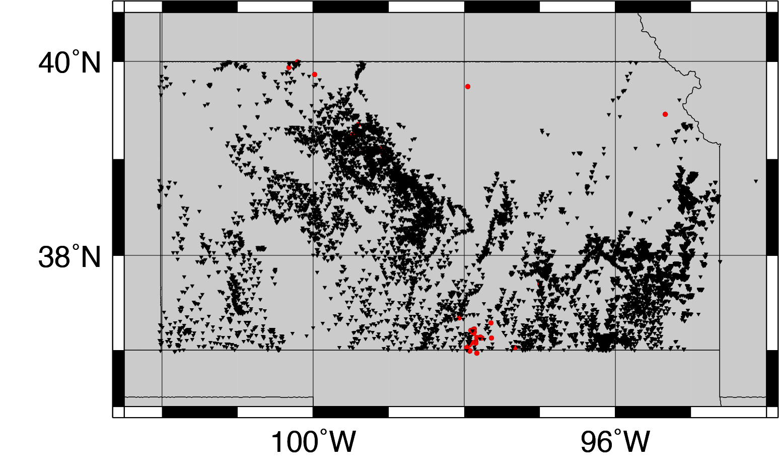
Fig. 14: Kansas earthquakes (red) and wastewater disposal wells (black). Click here for an interactive map of Kansas earthquakes and wells.
Colorado Earthquakes
New Mexico Earthquakes
Texas Earthquakes
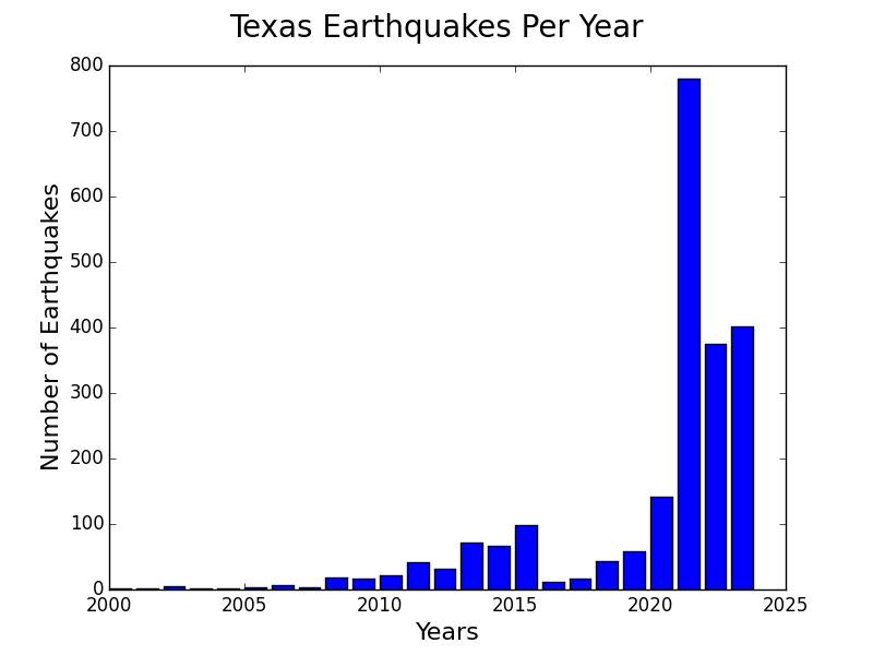
Fig. 21: Earthquakes in Texas spiked in 2011 and then again in 2013 (graph is updated daily using ANSS data)
Source: magma.geos.vt.edu
A study of the recent earthquakes that occurred in Ohio from 1990 to 2011 shows that the number has been increasing since the turn of the century and continues to do so. The data can be found on the Ohio Department of Natural Resource website: dnr.state.oh.us
Source: webberenergyblog.wordpress.com
Man-made earthquakes increasing in central and eastern U.S., study finds
For the first time, the U.S. Geological Survey has unveiled a map of earthquakes thought to be triggered by human activity in the eastern and central United States.
Oklahoma is by far the worst-hit state recently, according to the USGS study released Thursday. The state last year had more earthquakes magnitude 3 or higher than California, part of a huge increase recorded in recent years.
Seismic activity in Texas near the Dallas-Fort Worth area has also increased substantially recently. Kansas, Colorado, New Mexico and Ohio have all experienced more frequent quakes in the last year.
All of the areas highlighted on the map “are located near deep fluid injection wells or other industrial activities capable of inducing earthquakes,” the study said.
Mark Petersen, chief of the USGS' National Seismic Hazard Project, said the pattern of increased quakes is troubling.
“These earthquakes are occurring at a higher rate than ever before, and pose a much greater risk and threat to people living nearby,” Petersen said.


Source: latimes.com
State geologists compiled historical accounts of earthquakes recorded before 1964 and data from modern seismometers to compose an earthquake history of Virginia. Source: phys.org
USGS. 2013. “Earthquake Archive Search & URL Builder.” http://earthquake.usgs.gov/earthquakes/search. On this data portal, I searched for magnitude 2.0 or greater earthquakes using 1980-01-01 12:01:00 as the starting time and 2013-12-31` 11:59:59 as the ending time. I searched for a rectangle that approximated the State of Missouri, using 40.4891° as the northern boundary, 36.4985° as the southern boundary, -91.6478° as the western boundary, and -89.0994 as the eastern boundary. I selected this eastern boundary, even though it included some of Illinois, because I wanted to capture the portion of the New Madrid Zone in Missouri. I selected this western boundary, even though it omitted portions of Northwest Missouri because I wanted to omit the recent earthquake swarm in Oklahoma. I omitted the Illinois earthquakes from the data reported above, though they are shown on the map. Source: mogreenstats.com
Alaska shook from record number of earthquakes in 2014
13 January, 2015. Alaska experienced a busy year underground in 2014, according to experts who record the state's earthquakes.
The Alaska Earthquake Information Center detected 40,686 quakes in the state and bordering parts of Canada, significantly more that the previous high of nearly 32,000 in 2003, the Fairbanks Daily News-Miner reported.
In 2013, 28,000 earthquakes were detected with the center's seismometer network.
"We've blown away those benchmarks," said state seismologist Michael West. "There's never been a year where we identified 40,000 earthquakes in a year." Source: adn.com
Time-lapse video animation of earthquakes in and around Arizona from 1852 to 2011. The apparent increase in seismic events in the latter part of the 20th century and early 21st century stems from improved seismic monitoring. It is interesting to see where the most earthquakes occur.
Arizona earthquake numbers saw a large increase in 2011
11 April, 2011. According to the Arizona Geological Survey, 131 earthquakes were detected in 2011 compared with 53 in 2010. That was twice as many as in 2009 and about a third more than in 2008. Most of the earthquakes were in the northwestern part of the state. The Yuma area was also shaken by earthquakes associated with the Gulf of California Rift Zone. <...>
Source: wryheat.wordpress.com
Increase in earthquakes may be tied to groundwater pumping
For years, scientists have wondered what are the forces that keep pushing up California's mighty Sierra Nevada and central coast ranges, causing an increase in the number of earthquakes in parts of Central California.
On Wednesday, a group of scientists offered a new intriguing theory: that the quakes are being caused in part by pumping of groundwater in the Central Valley.
“These results suggest that human activity may give rise to a gradual increase in the rate of earthquake occurrence,” said the study published in the journal Nature Wednesday, written by scientists at Western Washington University, University of Ottawa, University of Nevada, Reno and UC Berkeley. <...> Source: latimes.com
Earthquake possible along new fault zone near Victoria say scientists
9 March, 2016. The Devil's Mountain Faults, indicated here by a red line, is actually made up of a series of faults that run from Washington to Victoria.
B.C. megathrust earthquake could rupture like a zipper, expert says
Seismologists in B.C. have confirmed the existence of a fault only five kilometres south of Victoria, giving South Coast residents one more thing to worry about when preparing for earthquakes.
It's called the Devil's Mountain Fault Zone and it's actually made up of a series of faults that run from Washington state to Victoria, running much closer to the B.C. capital than the point where the Juan de Fuca plate meets the North American plate, which scientists have predicted for decades will result in the 'Big One.' Source: cbc.ca
Risk of big earthquake on San Andreas fault rises after quake swarm at Salton Sea
1 October, 2016. The rumbling started Monday morning deep under the Salton Sea. A rapid succession of small earthquakes — three measuring above magnitude 4.0 — began rupturing near Bombay Beach, continuing for more than 24 hours. Before the swarm started to fade, more than 200 earthquakes had been recorded.
The temblors were not felt over a very large area, but they have garnered intense interest — and concern — among seismologists. It marked only the third time since earthquake sensors were installed there in 1932 that the area had seen such a swarm, and this one had more earthquakes than the events of 2001 and 2009. Source: latimes.com
USGS: New fault zone discovered following 2011 earthquake
11 February, 2015. The Aug. 23, 2011 Virginia earthquake may have been felt by more people than any other quake in U.S. history, and has led to the discovery of a new East Coast fault zone.
The magnitude 5.8 temblor marked the first time that a fault zone in the eastern United States produced a magnitude 5 or higher earthquake “clearly delineated by aftershocks,” according to a new report by the U.S. Geological Survey.
All those rattling aftershocks following the 2011 quake helped the USGS locate the new fault zone, which scientists have named the “Quail” fault zone.
“Most of these aftershocks were in the Quail fault zone, and outlying clusters of shallow aftershocks helped researchers to identify and locate other active faults,” the USGS said in a news release this week.
<...>
• New geologic mapping and trenching reveal previously unknown faults and evidence that the faults were active more than once in the past . Source: insidenova.com
-
Comment by Stanislav on October 22, 2016 at 6:43pm
-
Southeastern US sinking
[1] 25 May, 2015, Texas Flooding Called The Worst Ever By Governor. Source: huffingtonpost.com
[2] 29 May, 2015. Latest on flooding: Texas rain brings no major new problems - Article Photos. Source: newsok.com
[3] 1 June, 2016. Record floods hit US state of Texas again. Source: aljazeera.com
[4] 15 March, 2016. Texas governor visits communities engulfed by floods - Article Photos Source: newsok.com
[5] 27 June, 2016. West Virginia flood was ‘one in a thousand year event' Source: washingtonpost.com
[6] 25 June, 2016. Death Toll Rises to 24 in Devastating West Virginia Floods Source: nbcnews.com
[7] 28 December, 2015. Historic and unseasonable flooding overwhelms Central U.S., Mississippi River. Source: washingtonpost.com
[8] 30 December, 2015. Record Floods Affect Millions in the Midwest Source: nytimes.com
[9] 31 December, 2015. Shocking aerial photographs show devastation caused by historic Mississippi flooding that has killed at least 20 - and officials warn there are more deaths to come Source: dailymail.co.uk
[10] 5 October, 2015. Historic, 1,000-year flood ‘like nothing South Carolina has ever seen’ Source: postandcourier.com
[11] 6 October, 2015. Fourteen dead as South Carolina gripped by historic flooding Source: reuters.com
[12] 1 August, 2016. Deadly Maryland flood a '1-in-1,000' year event. Source: wtsp.com
[13] 30 July, 2016. Video and photos: Horrific flooding in ‘ruined’ Ellicott City, Md. Source: washingtonpost.com
[14] 24 January, 2016. Mid-Atlantic coastline flooded by blizzard’s storm surge. ‘This is worse than Sandy.’ Source: washingtonpost.com
[15] 10 March, 2016. Historic flooding leaves parts of Louisiana under water. Source: cbsnews.com
[16] 16 March, 2016. Floods in Texas, Louisiana, Mississippi and Oklahoma Leave 4 Dead, 2 Missing and 1000s of Homes Damaged Source: floodlist.com
[17] 16 August, 2016. Louisiana’s 1,000-year floods inundated 80,000 homes and businesses. Worst Louisiana flooding since Katrina. Source: varstechnica.com
[18] 17 August, 2016. Louisiana Flooding: Scope of Deadly Disaster as Told by the Numbers. Source: nbcnews.com
Coastal floods in US
[1] 2 October, 2015. Source: twitter.com
[2] 4 October, 2015. Six dead and hundreds stranded as dams break and cause 300 road collisions in ONE DAY during 1,000-year record rainfall across the Carolinas Source: dailymail.co.uk
[3] 10 June, 2015. Weekend Storm Soaks, Batters Coast Source: coastalreview.org
[4] 6 June, 2016. Tropical Storm Colin leaves flooded streets in Tampa Bay Source: tampabay.com
[5] 29 October, 2015. Your photos of Tybee Island flooding — and some heavy reading Source: politics.blog.ajc.com
Are Houston’s Sinking Suburbs Suffering Worse Flooding?
After the flooding last month in Houston, a local geologist noticed something that looked suspicious: some of the areas of Houston hit hardest were also areas where the land is sinking. The sinking is called “subsidence”. But there’s a debate over whether it’s actually making flooding worse.Top map shows worse subsidence in blue since the 1990s. Bottom map shows it moving northeast in 2011. Source: Journal of the International Society for the Prevention of Mitigation of Natural Hazards
23 May, 2016. What made last month’s flooding, especially in north Harris County, so bad?
Simple: a whole lot of rain says Mike Talbott, executive director of the Harris County Flood Control District.
“It has a lot to do with this phenomenal rainfall … people don’t want to talk about the rainfall,” Talbott tells News 88.7.
But people are talking about how other factors, besides the massive rainfall, may have made things worse. And one those people is a professor of geology at the University of Houston, Shuhab Khan.
“It’s making it worse,” says Khan.
What Professor Khan believes is making flooding worse in certain neighborhoods is a geological condition Houston and many cities suffer from and have for decades: subsidence. It’s where many acres of ground sink.
Historically in Harris County, subsidence has been worse in areas where over the decades, groundwater and oil and gas have been sucked out from under the ground, causing the land to sink by fractions of an inch a year, in some places by feet over many years.
Could it be that today, the ground that homes are built on is sinking in different places than it did decades ago and thus, could this make flooding worse in places where people say, “It never flooded like this before.”
When Professor Khan looked at maps showing where last month’s flooding damaged the most homes, those maps looked eerily similar to ones he’d drawn as part of a study two years ago, maps showing where subsidence was happening in Harris County.
“Those are the areas that are areas that are subsiding very rapidly. North and northwest. It used to be Jersey Village. (Now) it’s moving northeastwards, north and northeast these days. But it is the same area where the flooding was,” Khan tells News 88.7.
Khan says one subsidence zone is drifting northeast towards the Woodlands and seems to be affected by fault lines that traverse the area. Khan is not saying that subsidence alone is why there’s flooding.
“Of course there would be flooding. But maybe not huge,” says Khan. Source: houstonpublicmedia.orgKasmarek, Mark. 2013. Hydrogeology and Simulation of Groundwater Flow and Land-Surface Subsidence in the Northern Part of the Gulf Coast Aquifer System, Texas, 1891-2009. Scientific Investigations Report 2012-5154, Version 1.1, December 2013. U.S. Geological Survey. Figure 32, p. 47. Source: texaslandscape.org;
Caption: A map created using data from the United States Geological Survey shows how far Harris County has dropped in elevation since the 1920s. Though most of the region to the east has stabilized, areas to the west continue to subside at an significant rate, according to the agency. Remove the map to see which areas of Harris, Fort Bend and Montgomery County are experiencing decreasing aquifer levels. Source: houstonchronicle.com
Sinking Atlantic Coastline Meets Rapidly Rising Seas
Source: scientificamerican.com
14 April, 2016. Geological changes along the East Coast are causing land to sink along the seaboard. That’s exacerbating the flood-inducing effects of sea level rise, which has been occurring faster in the western Atlantic Ocean than elsewhere in recent years.
New research using GPS and prehistoric data has shown that nearly the entire coast is affected, from Massachusetts to Florida and parts of Maine.
Land subsidence and sea level rise are worsening flooding in Annapolis, Md., and elsewhere along the East Coast.
The relatively fast rate of rise in sea levels along the East Coast may have been a blip — for now. The rate of rise recorded so far this century may become the norm during the decades ahead. “Undoubtedly, these are the rates we’re heading towards,” said Simon Engelhart, a University of Rhode Island geoscientist.
Engelhart drew on data from prehistoric studies and worked with two University of South Florida, Tampa scientists to combine it with more modern GPS data to pinpoint the rates at which parts of the Eastern seaboard have been sinking.
<...>
The data suggests that some land in coastal Maine, New Hampshire and Massachusetts, on the other hand, is rising slightly, although not quickly enough to keep up with the global rate of sea level rise.The study shows that subsidence is occurring twice as fast now than in centuries past in a hot spot from Fredericksburg, Va. south to Charleston, which the scientists mostly blame on groundwater pumping.
<...>
Even without future warming, high tide flooding is already getting worse along the East and Gulf coasts, where subsidence and erosion are rife. The problems become most plainly clear during king tides.“We can have up to 4-foot tides,” said Christine Voss, a University of North Carolina, Chapel Hill ecologist involved with a project that’s documenting the effects of king tides. “People are noticing that these flooding events are occurring more frequently, and perhaps with greater depth of inundation.” Source: climatecentral.org
-
Comment by Stanislav on October 22, 2016 at 6:42pm
-
Chesapeake Bay
Source: Land Subsidence and Relative Sea-Level Rise in the Southern Chesapeake Bay Region (By Jack Eggleston and Jason Pope) pubs.usgs.gov
Land subsidence can also increase flooding in areas away from the coast. Low-lying areas, such as the Blackwater River Basin (fig. 2), can be subject to increased flooding as the land sinks. Locations along the Blackwater River in the city of Franklin and the counties of Isle of Wight and Southampton have experienced large floods in recent years (fig. 5; Federal Emergency Management Agency, 2002). Land subsidence may be altering the topographic gradient that drives the flow of the river and possibly contributing to the flooding.
Source: Land Subsidence and Relative Sea-Level Rise in the Southern Chesapeake Bay Region (By Jack Eggleston and Jason Pope) pubs.usgs.gov
Gulf of Mexico sinking
Top maps show vertical and horizontal velocity vectors in (a) southeastern Louisiana and (b) Houston. Bottom plots show vertical positional time series of subsiding stations in (c) southeastern Louisiana (> 1.5 mm yr?1) and (d) Houston-Galveston (>4.5 mm yr?1). The reference frame is SGOMRF.
Source: Yu, J., & Wang, G. (2016). GPS-derived ground deformation (2005–2014) within the Gulf of Mexico region referred to a stable Gulf of Mexico reference frame. Nat. Hazards Earth Syst. Sci, 16, 1583-1602. nat-hazards-earth-syst-sci.net CC Attribution 3.0 License
Vertical velocity vectors of 148 CGPS stations (> 4 years) in the Gulf of Mexico region. green dots represent the 13 reference stations. The blue vectors represent the average velocities referred to SGOMRF.
Source: Yu, J., & Wang, G. (2016). GPS-derived ground deformation (2005–2014) within the Gulf of Mexico region referred to a stable Gulf of Mexico reference frame. Nat. Hazards Earth Syst. Sci, 16, 1583-1602. nat-hazards-earth-syst-sci.net CC Attribution 3.0 License
Locations of three CGPS stations and cities within the greater Houston area. Black and blue velocity vectors represent horizontal and vertical velocities with respect to SGOMRF, respectively. Red lines are growth faults and yellow dots are salt domes (Garrity and Soller, 2009). Contours lines are subsidence rate from 2005 to 2012 (Kearns et al., 2015)
Source: Yu, J., & Wang, G. (2016). GPS-derived ground deformation (2005–2014) within the Gulf of Mexico region referred to a stable Gulf of Mexico reference frame. Nat. Hazards Earth Syst. Sci, 16, 1583-1602. nat-hazards-earth-syst-sci.net CC Attribution 3.0 License
Houston-Galveston area, Texas
Map showing contours of the average subsidence rate (mm/year) during the time span from 2006 to 2012. The contours are derived from subsidence observed from 72 GPS stations and 13 borehole extensometers. The red lines represent the locations of about 150 principle faults mapped by USGS in the Houston area using airborne LIDAR data collected after tropical storm Allison in 2001
Source: Yu, J., Wang, G., Kearns, T. J., & Yang, L. (2014). Is there deep-seated subsidence in the Houston-Galveston area?. International Journal of Geophysics,2014. Source: researchgate.net This is an open access article distributed under the Creative Commons Attribution License, which permits unrestricted use, distribution, and reproduction in any medium, provided the original work is properly cited
Recent horizontal and vertical ground deformation velocity vectors in the Houston-Galveston area derived from extensometer and GPS observations (2006–2012). The horizontal velocity vectors have been transformed to the stable Houston reference frame (SHRF). The red lines represent the locations of about 150 principle faults mapped by USGS in the Houston area using airborne LIDAR data collected after tropical storm Allison in 2001.
Source: Yu, J., Wang, G., Kearns, T. J., & Yang, L. (2014). Is there deep-seated subsidence in the Houston-Galveston area?. International Journal of Geophysics, 2014. researchgate.net This is an open access article distributed under the Creative Commons Attribution License, which permits unrestricted use, distribution, and reproduction in any medium, provided the original work is properly cited
[1] Yu, J., Wang, G., Kearns, T. J., & Yang, L. (2014). Is there deep-seated subsidence in the Houston-Galveston area?. International Journal of Geophysics,2014. Source: researchgate.net This is an open access article distributed under the Creative Commons Attribution License, which permits unrestricted use, distribution, and reproduction in any medium, provided the original work is properly cited
New Orleans is sinking faster than previously thought
Source: eos.org
When a city already sits below sea level, any additional sinking is cause for concern, says the Weather Channel. This is especially true of New Orleans, a major U.S. port with the largest metropolitan area in the state of Louisiana.
Scientists have known for some time that the "big easy" is sinking, but a new study has found that New Orleans and the surrounding metropolitan area is losing elevation at a faster rate than previously thought, says the Weather Channel.
The sinking is a process called subsidence, and with the use of satellite mapping, it was found that different areas of the city are sinking at varying rates, some as much as two inches or more a year due to a combination of natural geologic and human-induced processes Source: digitaljournal.comMaking sense of senseless sea level scares in Norfolk Virginia – 60% of the rise is from subsidence, the remainder from landfill settling (show PSMSL)
Source: wattsupwiththat.com
No solid ground
19 February, 2015. In the Raton Basin on the Colorado-New Mexico border, the U.S. Geological Survey has found evidence of subsidence in satellite images that is connected to underground water or gas withdrawal. The area had experience induced seismicity — increased seismic activity that was caused by wastewater injection in the area — and had begun to study surface deformation that followed a magnitude 5.3 earthquake that occurred there in 2011, which U.S. Geological Survey research had determined was induced.
In the satellite images used to study the ground surface deformation — which was occurring in the range of 5 mm to 10 mm per year — researchers could also see substantial ground subsidence that was likely tied to extraction of natural gas, says William Barnhart, a former research geophysicist for the U.S. Geological Survey and lead author of a study on the area that was recently released in the Journal of Geophysical Research. Source: boulderweekly.com
‘Nuisance flooding’ exceeds trends, breaks records in the United States: NOAA
8 June, 2016. Source: canadianunderwriter.ca
West US some sinking areas
San Joaquin Valley is sinking
28 October, 2015. Land all over the San Joaquin Valley is sinking. In some spots, the elevation has dropped more than two stories - mainly through the pumping of water from underground aquifers.
The sinking, or subsidence, occurs at different rates in different places. In some places, sinking has reached a rate of a foot a year. Source: yourcentralvalley.com
2 inches a month: California sinking faster than ever, infrastructure in danger
20 August, 2015. The rate at which land across vast areas of California are sinking due to overconsumption of groundwater is higher than ever, with some places subsiding two inches a month, a new NASA report says. It comes as the state’s farmers pump water faster amid the historic drought.
While California has been sinking for decades, the current rate is among the highest ever measured around the world. The alarming findings of NASA’s Jet Propulsion Lab are based on satellite and aerial photos and measurements of land subsidence in the state.
An area near Corcoran, in the Tulare basin, sank 13 inches in one recent eight-month period, according to the study conducted for the State Department of Water Resources. A stretch near the California Aqueduct, a key leg of the state canal and pipeline system that brings freshwater from the Sierra Nevada Mountains, sank 8 inches in just four months last year.
The problem is not limited to the San Joaquin Valley, the most arid part of the Central Valley of California. Land near Arbuckle in Colusa County sank five inches during the last half of 2014, the NASA report said.
Heavy pumping of groundwater causes clay between water pockets to collapse and ground to sink. This may damage critical infrastructure and also makes it harder for groundwater reservoirs to replenish. It may also hinder water from flowing through its natural underground pathways.
“Roads can be broken by fissures, pipelines have been exhumed, and the slope of the land can be altered, changing drainage patterns,” the NASA report warns.
Groundwater consumption remains at a historic high amid the drought, while its levels are dropping to record lows of up to 100 feet below previous measurements, says Mark Cowin, head of the California Department of Water Resources. Source: rt.com
GNSS (green points)-derived vertical displacement rates (negative of subsidence rates) in the Central Valley (includes the San Joaquin and southern portion of the Sacramento Valleys inside the boundary in purple), California, (Sec. S1, SI).
The planned California High-Speed Rail (CHSR) is red alternating with white line. GMT36 V5.1.3 is used to plot Fig. 1 (http://gmt.soest.hawaii.edu/). Overlapped are TOPEX/POSEIDON (red line) and ENVISAT (orange line) satellite ground tracks (labeled as satellite abbreviation-pass number), where vertical displacement rates at a 1-km interval are derived from the two altimeters (see Fig. 3). The topography is from the digital elevation model of SRTM15_PLUS37.
Near Hanford, California, subsidence rates reach 18cm yr1 with a cumulative subsidence of 206cm, which potentially could adversely affect operations of the planned California High-Speed Rail.
Hwang, C., Yang, Y., Kao, R., Han, J., Shum, C. K., Galloway, D. L., ... & Li, F. (2016). Time-varying land subsidence detected by radar altimetry: California, Taiwan and north China. Scientific Reports, 6. This work is licensed under a Creative Commons Attribution 4.0 International License. nature.com
GPS data:
Blewitt, G., C. Kreemer, W.C. Hammond, J. Gazeaux, 2016, MIDAS robust trend estimator for accurate GPS station velocities without step detection, accepted for publication in the Journal of Geophysical Research, doi: 10.1002/2015JB012552. geodesy.unr.edu; data
Subsidence area in Arizona data. Source: azwater.gov; Cracks, earth fissures in Arizona data. Source: azgs.az.gov
Is the recent sinkhole in Mexico City an effect of the stretch zone? I assume that it is based on reports on its size and appearance. [and from another] Massive Sinkhole Opens in Mexico City [July 9] http://www.msnbc.msn.com/id/19682106/ Even in a city where historic buildings regularly lean, crack, collapse or sink below sidewalk level due to excessive water extraction and unstable soil, the 45-foot-deep sinkhole - which measures about 15 yards in diameter - came as a shock.
We have mentioned that N America is being bowed and pulled on a diagonal, and at some point large quakes along the New Madrid will occur. Mexico is being pulled to the West, while New England is being pulled to the East. In addition, the West Coast is being pulled into a bow near the Southern California area, which will create cracks in the Arizona area. The recent sinkhole in Mexico is only more evidence of this.
ZetaTalk: GodlikeProduction Live written July 14, 2007
ASU study: Parts of metro Phoenix area are sinking
12 August, 2015. Ground elevation levels in Apache Junction are seeing the fastest drop, followed by Sun City West, Peoria and the north Valley, ASU researchers say.
Scientists at ASU’s School of Earth and Space Exploration say ground-elevation levels in Apache Junction are seeing the fastest drop. Sun City West, Peoria and the north Valley are also descending.
<...> State officials have been aware of what’s called “land subsidence” — where the earth collapses and drops —for years. The Arizona Department of Water Resources is working with NASA to collect radar data to compliment the department’s data and maps on where land has subsided. The department has been collecting and processing data since 2002 to monitor land subsidence, which is occurring over 2,800 square miles in Arizona. The department says land subsidence has been happening in Arizona since the early 1900s with parts of Maricopa and Pinal Counties subsiding more than 18 feet since then. In Arizona, land subsidence in so-called geographical basin areas like the Valley is usually due to a lowered water table, according to the department.
But not all areas of the Valley are sinking, the ASU study found. Parts of Scottsdale, Chandler and Mesa have risen by as much as half a centimeter. ASU scientists say they did not observe a change in most of the city of Phoenix.
<...>
But even with the reduced groundwater pumping — and subsequent increase in the groundwater level — research published in 2005 and 2011 found the ground continued sinking and cracking in parts of the Phoenix metro area and other locations, including Tucson, Casa Grande and Eloy.
<...> The ground sinking is not unique to the Valley. It’s also occurring in southwestern Arizona and agricultural valleys in California.
Land subsidance also has been identified in Denver, Colo., the New Jersey coast, Savannah, Ga., and New Mexico’s Albuquerque Basin. The U.S. Geological Survey has identified more than 17,000 square miles of land subsidence in 45 states, an area equivalent to the size of New Hampshire and Vermont combined.
<...> Source: azcentral.com
New fault near San Diego (ZetaTalk)
Should california expect much in the way of volcanic activity. I live near Mammoth Mountain,and am very worried it could errupt due to the influences of PX.
We have chimed in with Scallion on suspecting that a rip will occur from San Diego up toward Yellowstone, as there is a fault line there. Why would this rip, in a manner that would disrupt Mammoth? As we have stated in detailing the Earth Torque, wherein New England is pulled toward the East and Mexico toward the West, pulling the N American continent in a diagonal, fault lines will not be stressed in their traditional ways, but in new ways, during the coming months. New Madrid is an example. East of the Mississippi, going up, West of the Mississippi, going down. In a similar manner, the fault line from San Diego to Mammoth, and on up toward Yellowstone, will find the land South going West, with Mexico, and North staying with the land above this fault. Thus, should such rupture take place, in stages, evacuate Mammoth Lake!
ZetaTalk: GodlikeProduction Live written Sep 9, 2006
Baja earthquake. An unknown fault
20 November, 2011. After the El Mayor-Cucapah earthquake, scientists compared ascending (left) and descending (right) tracks from Synthetic Aperture Radar satellite images from the Advanced Land Observing Satellite to map how the land surface changed. The rupture did not occur on any of the region’s three main faults, indicated by red lines. When scientists looked at where the most earthquake displacement happened, they discovered a previously unknown fault in Mexico’s Cucapah Mountains, indicated by the blue shaded area. (Courtesy M. Wei and D. Sandwell)
Immediately after the El Mayor-Cucapah earthquake, scientists set out to find the fault that may have caused it. They suspected that the earthquake originated on one of two faults, the Cerro Prieto Fault or the Laguna Salida Fault, because the earthquake was centered between the two.
<...>
The resulting InSAR maps helped field scientists searching for the fault to navigate the rugged mountain terrain. “Field geologists took the InSAR maps and knew exactly where to go in the field to measure the fault lines,” said Sandwell. As Mexican researchers followed the fault lines and examined the freshly fractured landscape, they realized they were tracing neither of the suspected faults. They had discovered an entirely new one.This new fault, named the Indiviso Fault after the nearby Mexican town of El Indiviso, provides scientists a piece of California’s tectonic puzzle. “The fault that caused the El Mayor-Cucapah earthquake was not where anyone expected a fault,” Sandwell said. “The faults that have the high slip rates are where you’d expect all the big earthquakes. But that’s not where we’ve had the big earthquakes over the last forty years. That’s sort of scary,” Sandwell said.
Geologists measure the surface rupture caused by the El Indiviso Fault, which shifted the land surface as much as 1.2 meters (4 feet) in this location. (Courtesy C. Crosby)
Source: earthdata.nasa.gov
New analysis reveals large-scale motion around San Andreas Fault System
20 June, 2016. An array of GPS instruments near the San Andreas Fault System in Southern California detects constant motion of Earth's crust—sometimes large, sudden motion during an earthquake and often subtle, creeping motion. By carefully analyzing the data recorded by the EarthScope Plate Boundary Observatory's GPS array researchers from the University of Hawai'i at Manoa (UHM), University of Washington and Scripps Institution of Oceanography (SIO) discovered nearly 125 mile-wide "lobes" of uplift and subsidence—a few millimeters of motion each year—straddling the fault system. This large scale motion was previously predicted in models but until now had not been documented. Source: phys.org
SEARCH PS Ning or Zetatalk
This free script provided by
JavaScript Kit
Donate
© 2025 Created by 0nin2migqvl32.
Powered by
![]()
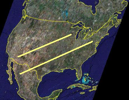

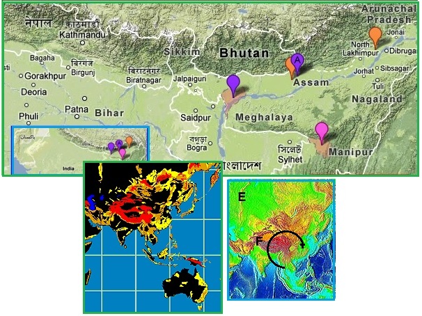


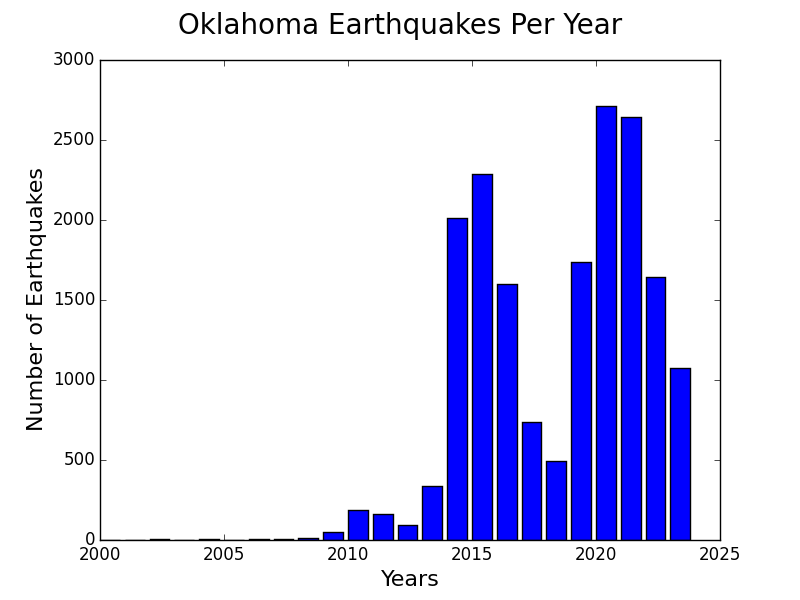
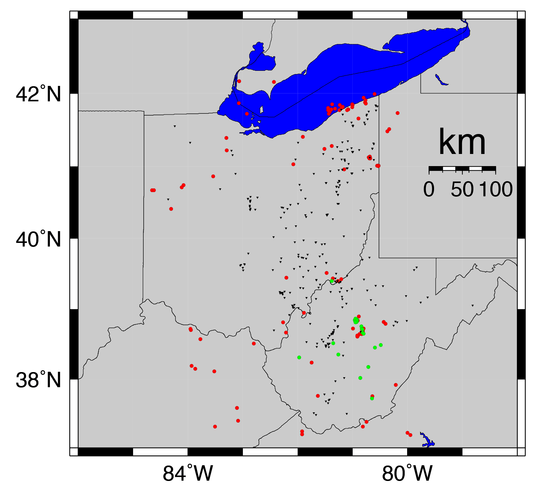
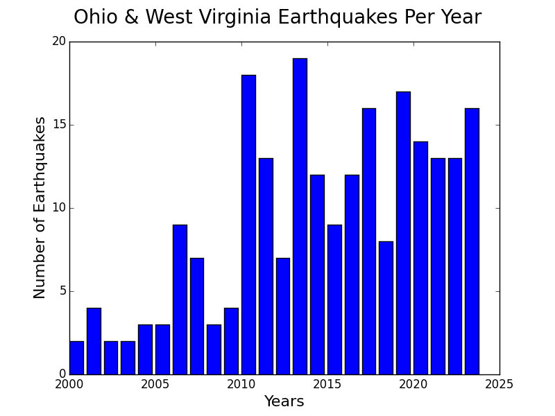
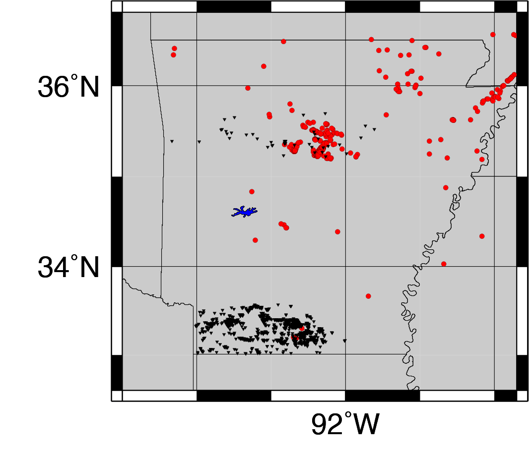
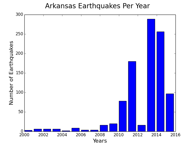
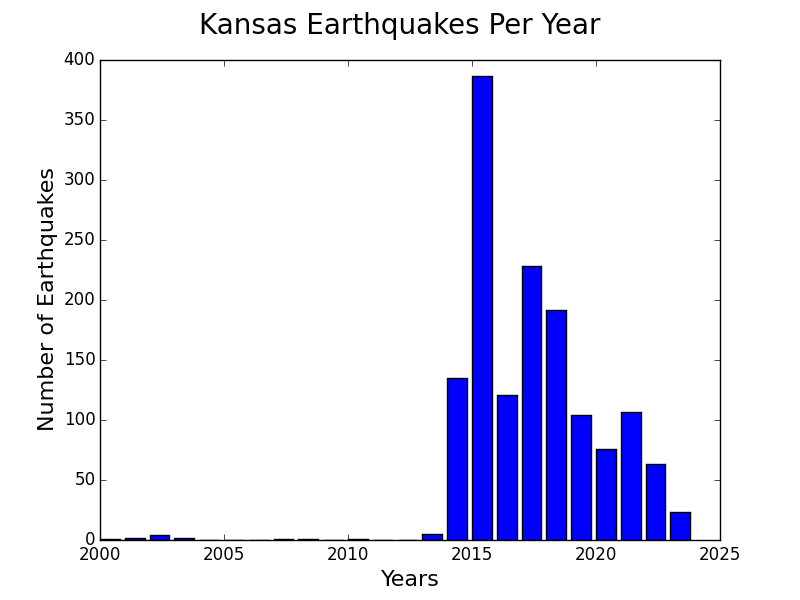

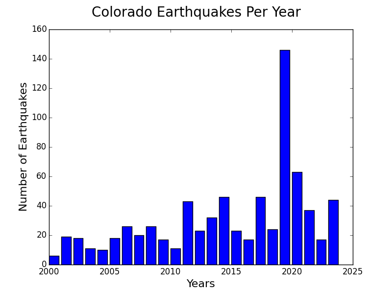
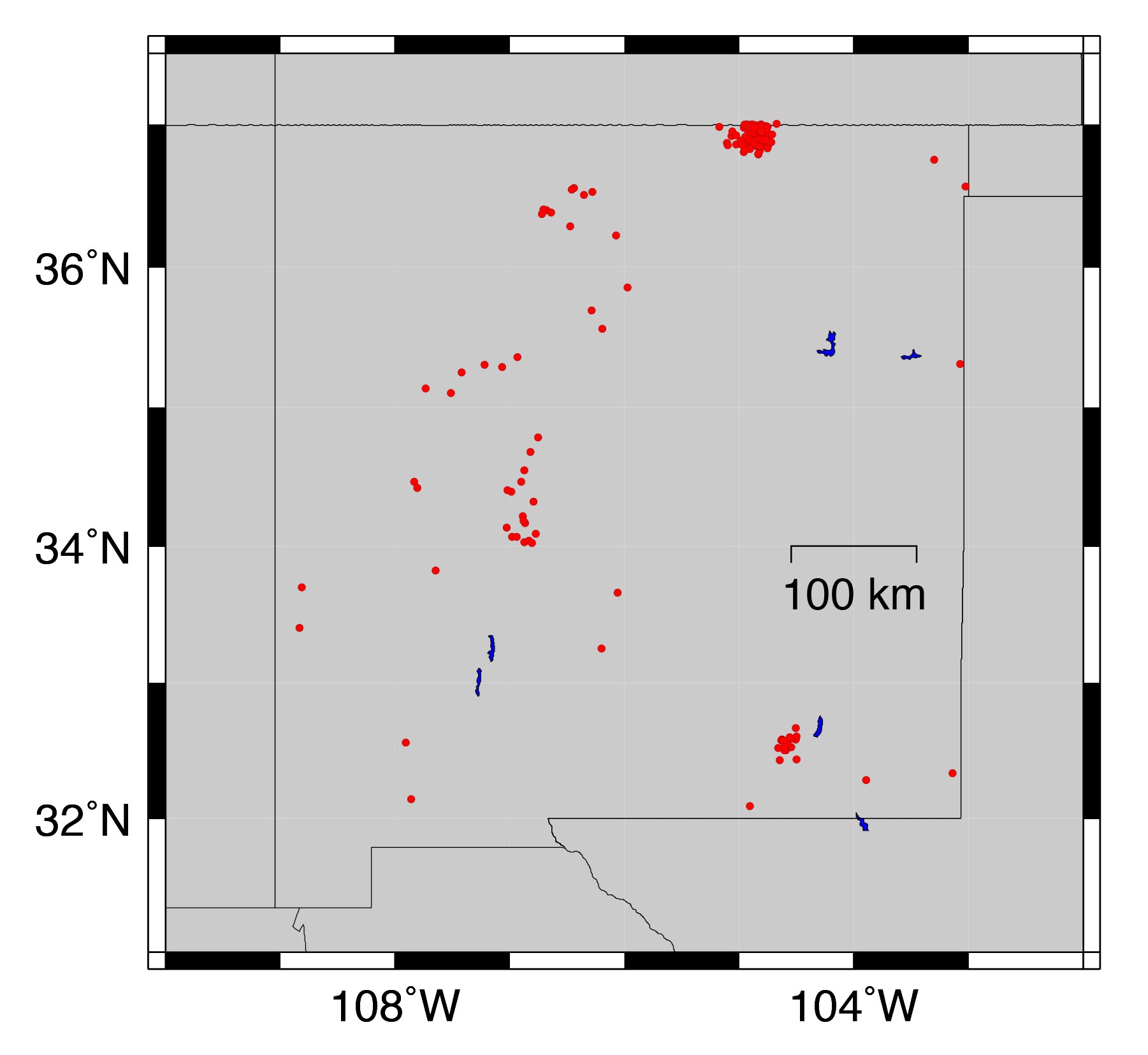
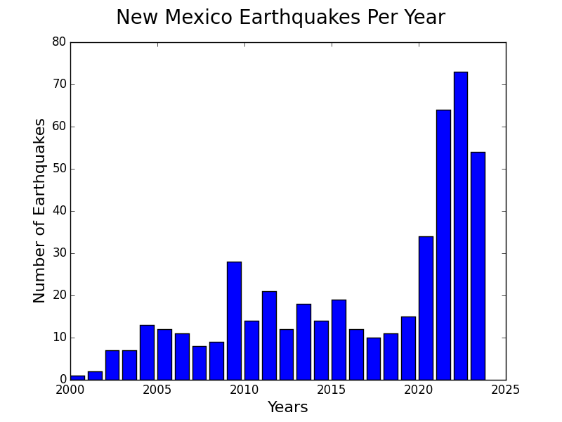
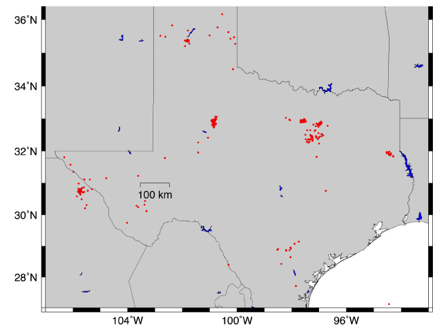


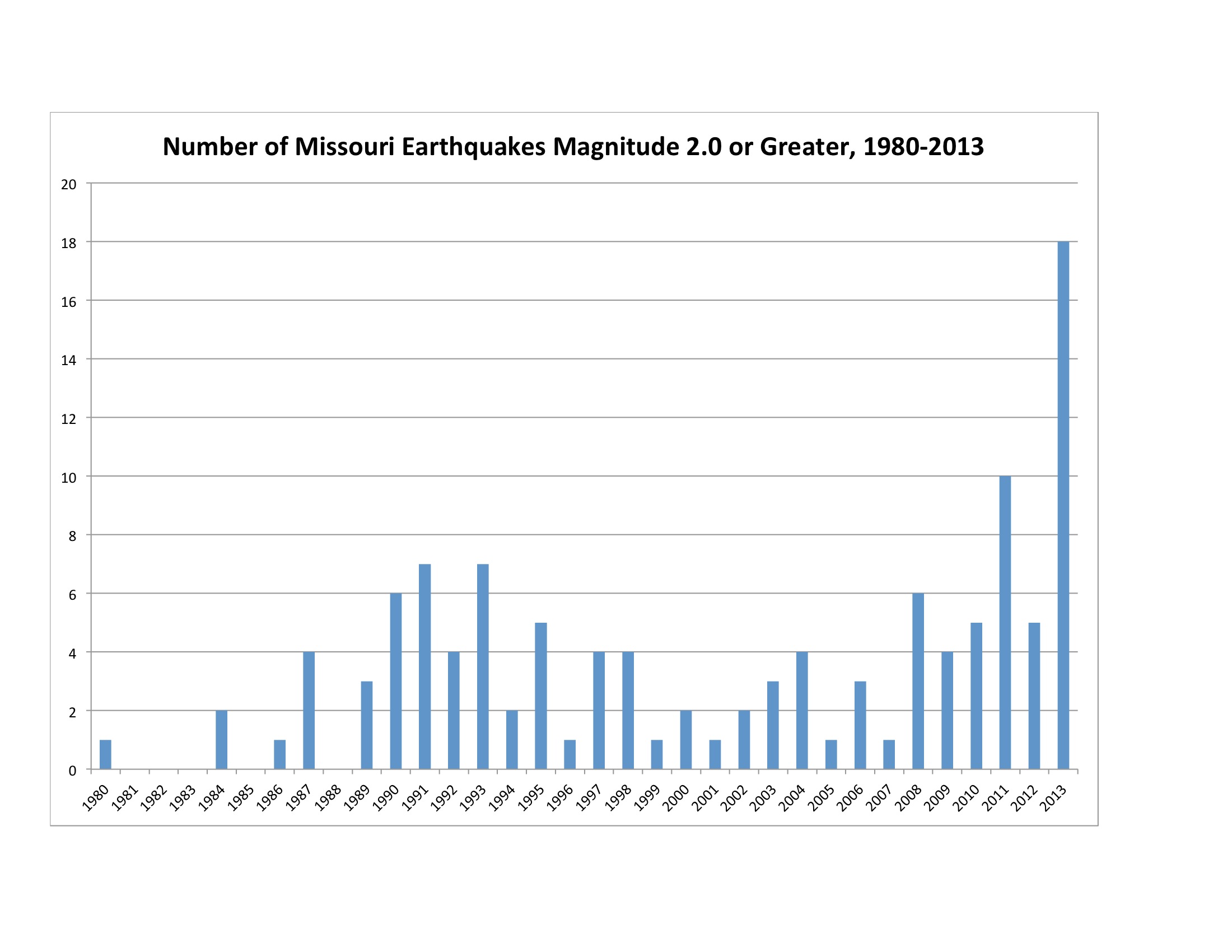


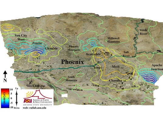


You need to be a member of Earth Changes and the Pole Shift to add comments!
Join Earth Changes and the Pole Shift