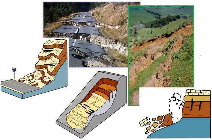
"The causes of landslides are not a mystery to mankind. Layers of rock and soil such that rain running along a clay or rock layer can create a slippery surface for the weight of the layers above it is a common cause. A rock jumble from previous mountain building, broken or fractured rock easily dislodged. We have stated that the earthquakes man experiences between the periodic passages of Planet X can be considered aftershocks from the last passage, and this is true of landslides also. Mountain building rumples the landscape, so the land is not flat but has steep ravines and hill sides. Older mountain ranges are recognized for their rounded or smoothed appearance, because of frequent landslides distributing the rubble.
"As we approach another passage, another Pole Shift, the pace of landslides has picked up. Why would this be? Plates under pressure will put pressure on regions that contain rumpled hillsides and deep ravines, as these give more readily than strictly flat land, thus act as a weak link. In addition, due to the wobble, the weather has gotten more extreme, with drought and deluge increasing in extremes. Dry ground, suddenly flooded with rainwater needing to seek its level as runoff, will create internal water slides between the rock and soil layers that constitute the rumpled hillsides. Is there an early warning system that mankind could use? The trembles that soil about to slide emits could be detected, yes. These are not earthquakes, and have their own frequency. "
Comment
http://www.dailymail.co.uk/news/article-2439778/5-hikers-killed-Col...
PUBLISHED: 01:10 GMT, 1 October 2013 | UPDATED: 02:03 GMT, 1 October 2013
Five hikers in Colorado have been killed after a rock slide buried them under boulders 'half the size of cars' on a popular trail.
A 13-year-old girl is the lone survivor from group. She was rescued from the debris field and flown to the Children's Hospital of Denver.
The hikers were buried Monday morning on a short mile-and-a-half trail at Agnes Vaille Falls near Mount Princeton - 130 miles southwest of Denver.
Rescuers: One 13-year-old girl was flown to a hospital after being pulled from the rubble. Her condition is not known
Trapped: Five hikers are buried beneath untold tons of rock and rubble Monday night and rescuers are afraid even more could come down on them if they stay at the site
27.09.30. Landslide, dozens of cracks and geological fault one kilometer long appeared in Rosario Ibarra, Chilpancingo, México. Residents said they heard a loud subterranean thunder, so some people have left their homes.
http://es-us.noticias.yahoo.com/fotos/lluvias-abren-enormes-grietas...
23.09.13. In Bocas cracks affected five communities, houses of 150 families are in danger of collapse.
http://pulsoslp.com.mx/2013/09/23/en-riesgo-150-familias-por-grietas/
23.09.13. Landslide in Zacapoaxtla, Puebla
http://municipiospuebla.com.mx/nota/2013-09-23/zacapoaxtla/construi...
25.09.13. Cracks in the Santa Gertrudis. Amira Ramos, a resident of the city said, that "obviously, we have more than 30 days from the aftershocks, recently we have up to 40 aftershocks within 24 hours, we did not sleep ...".
http://noticiasdechihuahua.com.mx/noticias-de-chihuahua-la-voz-cuah...
Penang Hill, Penang Malaysia
By CHONG KAH YUAN and LOGEISWARY THEVADASS
newsdesk@thestar.com.my
A bird’s eye view of a hill slope where soil erosion had occurred at Solok Tanjung Bungah.
“GEORGE TOWN: At least 13 locations in and around Penang Hill were hit by landslides following several days of downpour.
Bukit Bendera MP Zairil Khir Johari said soil erosion had occurred on several areas along the jeep trail, causing trees to be uprooted.
“Fortunately, there were no casualties. We advise the public to practise extreme caution when within the affected areas.
“The road at KM2.1 is intact and vehicles can pass through. However, half the road at KM4 has been damaged,” he said.
Zairil added that repair works would take about four months because of logistical problems.
“This problem has also resulted in the cost of the remedial works to escalate to RM1mil for each location,” he said. Zairil added that the area along KM2.5 had been cordoned off for safety reasons.
“Kebun Bunga assemblyman Cheah Kah Peng said the landslide was first detected on Sunday, but three major ones happened on Wednesday and Thursday.
“We will soon arrange a meeting with the residents and hikers who frequent KM2.5 (popularly known as Point 84) where there is a rest area,” said Cheah.
Meanwhile, residents in Tanjung Bungah are worried for their safety after several landslides also occurred there at around 11pm on Thursday.
A resident from a condominium, who was taking his usual morning walk in Solok Tanjung Bungah, said mounds of earth and a big boulder crashed down from the hill on Wednesday morning.
Another landslide occurred the following day.”
http://www.thestar.com.my/News/Nation/2013/09/14/Penang-Hill-hit-by...
Number of landslides hitting Britain up fivefold in a year:
http://www.dailymail.co.uk/news/article-2418047/Number-landslides-h...
Fewer than 60 landslides are reported on an average year, according to the British Geological Survey (BGS), but in 2012 there were 176.
In December 2012 alone there were 75 incidents, and the phenomenon continued into 2013, with 56 occurring in January.
Scientists found that in the 12 months following June 2012, there were five times the average incidents.
http://ibnlive.in.com/news/massive-landslide-in-arunachal-due-to-ra...
Massive Landslide in Arunachal India
September 8, 2013
With improvement in the weather, the water level of major rivers in Eastern Arunachal showed a receding trend even as West and Upper Siang districts in the state remained cut off due to massive landslides triggered by torrential rain. Chief Minister Nabam Tuki on Saturday undertook an aerial survey of the affected areas accompanied by Chief Secretary Hari Krishna and Secretary, Disaster Management, Kapa Kholie, officials said on Sunday. Reports had poured in of the Noa Dihing River rising over danger level and inundating portions of Dumpani and four other villages under Diyun circle in Changlang district. Massive landslide in Arunachal due to rainfall, 2 districts remain cut off At least 13,246 people of eleven villages have been affected by the current wave of flood. Landing at Diyun, Tuki took first hand report of the situation from local Legislator C C Singpho and officials of the district administration, sources said. The swollen river has triggered landslides in at least seven villages while about 85 hectares have been submerged in five villages, they said. Another five villages are under danger of being affected if the river continued to be in spate or proper preventive measures are not taken up immediately, sources said. To a plea for adequate fund to tackle the situation urgently, the chief minister announced an amount of Rs 2.5 crore for emergency protection works, particularly at Dumpani village, and directed Secretary, Disaster Management, to release the same to the district administration by Monday. Meanwhile, the district administration has provided 10,000 gunny bags to villagers for erection of temporary embankments/bunds at vulnerable locations. At least ten families living near the river bank have been directed to shift to safer locations and necessary assistance is being provided to them for relocation. The chief minister also took an aerial survey of all affected areas at Namsai, Chowkham, Mahadevpur and Tezu in Lohit district, Roing and Dambuk in Lower Dibang Valley and Mebo and Pasighat areas in East Siang district. At Pasighat, he was apprised of the flood situation by the district administration officials. The rising waters of Siang River have been causing concern for the people of the area and an alert has been sounded by the administration. An official of the Border Road Organization assured Tuki that the eroded approach to Siku Bridge on NH 52 between Pasighat and Mebo would be restored soon. While appealing to the people to remain vigilant, Tuki requested the Union Home Ministry to send a team to survey and assess the damages caused due to the flash floods. He also directed the district administrations to keep in stock enough ration items and medicines besides keeping men and machinery ready to tackle any eventuality
http://www.himvani.com/news/2013/08/29/devastating-landslide-tirah-...
August 29, 2013
Ffifteen army houses were razed to ground and over a dozen houses were badly damaged as a massive landslide struck the area. The houses were mainly of ex-servicemen. The incident took place at Tirah Lines which is almost 5 kms from Dharamshala.
There was no loss of life as people moved to safer places as soon as they got to know about this. The news went viral. In no time army reached the place and helped the victims. Mrs. Parvati, a resident of the place said, “Army men followed by Himachal police, home-guards, people from taxi stand and nearby areas helped us in tough times”.
The place was later visited by Mr. Sudhir Sharma, who overlooked the situation and promised to help the victims. At that time, victims were residing in tents in army area. But now, government has provided them with apartments in I&PH colony at Darnu, which is few kilometers from Dharamshala. This accommodation is provided to them for the next one year. The Government also promised to provide all the families with a monetary compensation of Rs. 3 lakhs and land in Molly, Khanyara.
The victims are trying hard to get back on track, but are still facing some problems. There are nearly two families residing in each apartment which is provided by the government. They are also facing problems to cook food for themselves because of shared kitchens. Mr. S.R. Thapa says, “Many of our belongings are still lying at our damaged houses, and we can not even bring it because the accommodation is very small”. Though transportation facility was provided to them to move to other place, still they could not bring all of their things.
On the whole the victims are happy with the help provided by the government and the local masses.They are hopeful that the government will fulfill its promises.
http://www.abc.net.au/news/2013-09-01/taiwan-boulder-car-video-land...
http://www.youtube.com/watch?v=8wWuH7MIeCA
A driver has narrowly escaped being crushed beneath a massive boulder that tumbled across a road in Taiwan during a landslide.
A camera mounted on the dashboard of a second vehicle travelling behind the car captured the dramatic moment when the landslide hit the road and the boulder, several times the car's size, crashed down, stopping within metres.
Heavy rain has triggered a series of mudslides across Taiwan.
The near-miss took place on the island in Keelung City.
Rocks began shifting at the top of a hillside, and the video - posted on YouTube - shows the drivers below apparently oblivious to the danger until debris started raining down.
Elsewhere, 19 people were injured in a train derailment.
http://www.dailymail.co.uk/news/article-2406871/Landslide-Huge-clif...
PUBLISHED: 13:49 GMT, 30 August 2013 | UPDATED: 13:49 GMT, 30 August 2013
A huge section of cliff crashed into the sea at a popular resort, covering holidaymakers and residents in a cloud of red dust.
The rose-coloured rocks fell 200ft after the massive landslide, half-a-mile from the town of Sidmouth in Devon.
The area on the Devon coast is prone to landslides, with some residents worrying their homes will soon be next.
Holidaymakers and residents were shocked to see the rock falling from the cliff and into the sea
Locals first knew of Wednesday's landslide when they heard a massive rumbling sound coming from the cliff face.
They looked up to see a huge chunk of rock plunging into the sea while throwing up a towering dust cloud.
The slip occurred near properties at the notoriously unstable Pennington Point, where homes edge ever closer to the sea with each collapse.
Richard Thurlow, chairman of campaign group Save Our Sidmouth, said: 'It was a fairly major one, quite immense.
The red dust which was sprayed from the cliff covered local properties and eroded residents' gardens
'Outside my home, which is half a mile away, a fine red dust was deposited on all the flat surfaces
Landslide Resembling Waterfall Buries Highway in S. China (Aug 29)
Although blamed on rain, this looks more like a cascade of dry dirt and rock.
"The traffic in the Du'an City section of the national Highway 210 in south China's Guangxi region was completely handicapped by a landslide.
At the section in Jiangcheng Village, Gaoling Town, the mud and rocks covered the highway for dozens of meters. No vehicles or people were hit.
The stranded vehicles stretched for around three kilometers, as the section is one of the most important roads connecting Guangxi and southwest China. The landslide site was cordoned off dozens of meters away, banning entry.
http://www.ksdk.com/news/article/395429/28/Landslide-cripples-highw...
Hunting Landslides with Landsat [Earth Observatory: 30 August 2013]
If a landslide occurs in a remote mountain range but nobody sees or hears it, does it matter? Unequivocally yes, says Columbia University geophysicist and landslide specialist Colin Stark. Even when they occur in remote areas, large landslides can dam rivers and lead to devastating downstream floods.“It’s especially critical that we monitor ‘catastrophic’ landslides—fast-moving slides that involve more than a million tons of debris,” Stark says. “These are the most dangerous landslides, but they often go undetected.”
Stark is working to change that. Along with colleague Göran Ekström, he has pioneered a new method to detect landslides by analyzing seismic waves—the vibrations that radiate through Earth’s crust because of sudden movements of rock, ice, magma, or debris. Stark and his colleagues used the technique to locate the landslide shown in the satellite images above.
Automated earthquake detection systems are tuned to monitor intense, “short-period” waves produced by sudden slips along tectonic faults. Landslides produce seismic waves as well, though their short-period signal is weak. Instead, they make powerful long-period waves that are sometimes detectable at great distances.
Stark and Ekström are developing a computer algorithm to scan seismographic data specifically for the long-period waves associated with landslides. They started by applying their technique to historical data. As the pair detailed in a study published in Science, their approach detected about ten large landslides that occurred between 1980 and 2012 that did not register on standard earthquake-monitoring systems.
In July 2013, Stark and Ekström had an opportunity to test their technique in real time. On July 25, one of Stark’s colleagues, Clément Hibert, noted a possible landslide event in southeastern Alaska. Stark’s initial analysis of the seismic data suggested the slide occurred in eastern Alaska and had a mass of about 20 metric tons (44,000 pounds). However, seismic data alone could not tell the researchers exactly where the slide had occurred, only that it happened within a 25 square-kilometer (10 square-mile) area in the Wrangell Mountains.
That’s where satellites proved critical. When Stark informed the NASA Earth Observatory about the possibility of a slide, EO staff checked the imagery acquired by the Operational Land Imager (OLI) on NASA’s Landsat 8 satellite. Within a few days, they located the slide.
The landslide occurred in Wrangell-St. Elias National Park at 61.978° North latitude and 143.168° West longitude. Since the landslide is difficult to make out in the true-color OLI image below, the location has been highlighted in yellow. Click on the image to see how the landslide looks without yellow highlighting.
See also;
http://poleshift.ning.com/profiles/blogs/smoldering-mountaintop-in-...
This free script provided by
JavaScript Kit
© 2024 Created by 0nin2migqvl32. Powered by
You need to be a member of Earth Changes and the Pole Shift to add comments!
Join Earth Changes and the Pole Shift