EARTHQUAKES Worldwide! (Frequently Updated)
 Global Earthquake Maps
Regionally Specific Earthquake Maps
|
Related Informations:
Earthquakes during the poleshift Magnetic twist and the effects
|
Additional Information from the F.A.Q: Q: What is the "Earth Wobble"?
Q: How can I understand the Magnetosphere? - About the Magnetosphere
Q: Is there a relationship between disturbances in the magnetosphere and seismic activity? |
Altering Earthquakes:
As of late, I have observed that USGS and EMSC are a bit lax on their reports of earthquakes. Sometimes not seeing anything reported for hours from the last update, or seeing periods of 90-200 minutes with no earthquakes in between. My question is, are they leaving swarms of earthquakes out of their reports, or there are actually periods of no earthquakes?
SOZT: Greater than 90% of the earthquake activity is being altered by the USGS at present, which is under orders to prevent any clue being given to the public about the Earth changes caused by the presence of Planet X. Over a decade ago, the approach was to de-sensitize the live seismographs periodically, so the displays do not turn black worldwide, and to ignore the twice-a-day patterns showing up on these seismographs. Then any quakes that could be dropped were dropped. This was obvious to some who were watching the database manipulation. Quakes in the list would suddenly disappear. This was particularly the case where a quake happened in a remote location, or out in the ocean. Dumbing down the magnitude quickly followed, but in order to ensure the public did not notice, the USGS took control of all websites reporting quake statistics. At times, this control breaks, and discrepancies are reported to the public. Some countries rebel. Quake swarms are another source of control, as they pepper the databases with many quakes and skew the statistics, and thus are pulled from the database. Else the question is raised, why so many? EOZT
Will the USGS internet system be a reliable warning system for the European tsunami by registering on the net the New Madrid earthquake on the exact time it occurs?
SOZT: It will not be a lack of information from the USGS that will be the point of confusion during the earthquakes leading up to the New Madrid adjustment, it will be knowing which quake is the big one vs the many minor quakes preceding it. The USGS downgrades almost all earthquakes, to prevent meaningful statistics from being generated from their databases. They also exclude quakes whenever they can, but this is unlikely to happen in the New Madrid area as it is in the center of a populated land mass. Thus you will have magnitude 6 quakes that will be called a 5.2, magnitude 7 quakes called a 6.1, and when a magnitude 8 or greater quake occurs, it will be called a 6.9.
We would advise that rather than watching the USGS quake statistics, that you watch the Earth changes. The adjustment that will incite the European tsunami will involve bridges on the Mississippi breaking, and being impassable. The land to the west of the Mississippi will drop so that the Mississippi will become 50 miles wide in the state of Mississippi. Watch for this. The New Madrid adjustment will be several large quakes of magnitude 8-9, though will be listed as a lesser magnitude. As the N American continent continues to unzip up to and along the Seaway, the quakes will be less than a magnitude 8 but very destructive to Cleveland and Toledo and Buffalo and the inland locks along the Seaway. Thus it is not what the USGS says that should be watched, but the condition of the bridges on the Mississippi, the impact on the cities along the Seaway, and whether the inland locks are reported as inoperable. EOZT
Please collect earthquake-reports here. Significant Quakes or Magnitude 7+ can be posted separately.
[Edited by the Moderation]
Views: 577720
Comment
-
Comment by Tracie Crespo on October 24, 2016 at 1:23am
-
www.emsc-csem.org/Earthquake/earthquake.php?id=538738
Magnitude mb 5.8 Region KURIL ISLANDS Date time 2016-10-23 20:25:26.5 UTC Location 44.04 N ; 148.10 E Depth 30 km Distances 556 km E of Sapporo-shi, Japan / pop: 1,884,000 / local time: 05:25:26.5 2016-10-24
530 km SE of Yuzhno-Sakhalinsk, Russian Federation / pop: 177,000 / local time: 07:25:26.5 2016-10-24
114 km E of Шикотан, Russian Federation / pop: 2,100 / local time: 07:25:26.5 2016-10-24
2016-10-23 23:10:33.309min ago 40.76 N 124.24 W 16 2.0 OFFSHORE NORTHERN CALIFORNIA 2 IV 2016-10-23 22:59:37.920min ago 19.25 N 104.45 W 60 5.1 COLIMA, MEXICO 2016-10-23 22:47:25.032min ago 60.05 N 153.10 W 114 3.5 SOUTHERN ALASKA 2016-10-23 22:15:58.01hr 03min ago 45.33 N 150.77 E 66 5.3 KURIL ISLANDS 2016-10-23 20:29:01.82hr 50min ago 19.20 N 155.48 W 36 2.2 ISLAND OF HAWAII, HAWAII F 2016-10-23 20:25:26.52hr 54min ago 44.04 N 148.10 E 30 5.8 KURIL ISLANDS 8 IV 2016-10-23 19:41:58.43hr 37min ago 37.20 N 22.02 E 2 4.3 SOUTHERN GREECE 2016-10-23 19:32:46.73hr 47min ago 18.33 S 177.71 W 600 4.3 FIJI REGION 2016-10-23 18:59:15.74hr 20min ago 39.46 N 20.62 E 10 4.1 GREECE 2016-10-23 18:57:27.14hr 22min ago 19.38 N 155.24 W 3 2.1 ISLAND OF HAWAII, HAWAII 2016-10-23 17:25:52.15hr 54min ago 17.88 N 65.65 W 14 2.3 PUERTO RICO REGION 2016-10-23 16:52:00.06hr 27min ago 59.04 N 154.08 W 112 3.0 SOUTHERN ALASKA 2016-10-23 16:27:52.16hr 52min ago 38.82 N 122.80 W 12 2.2 NORTHERN CALIFORNIA 6 IV 2016-10-23 15:56:39.27hr 23min ago 26.02 N 90.24 E 10 4.6 ASSAM, INDIA 2016-10-23 15:51:14.57hr 28min ago 34.35 N 116.17 W 1 2.0 SOUTHERN CALIFORNIA 2016-10-23 12:48:56.810hr 30min ago 19.53 N 65.31 W 67 2.7 PUERTO RICO REGION 2016-10-23 11:20:10.011hr 59min ago 61.93 N 151.72 W 93 3.9 SOUTHERN ALASKA 2016-10-23 11:03:17.6 11.69 S 89.30 E 10 5.1 SOUTH INDIAN OCEAN 2016-10-23 10:37:30.7 19.83 N 66.18 W 62 3.4 PUERTO RICO REGION 2016-10-23 08:43:19.4 19.21 N 155.48 W 35 2.2 ISLAND OF HAWAII, HAWAII 2016-10-23 08:22:03.1 38.34 N 42.06 E 10 4.2 EASTERN TURKEY 2016-10-23 07:33:09.7 36.92 N 121.41 W 8 2.3 CENTRAL CALIFORNIA 2016-10-23 07:26:59.0 2.98 S 147.83 E 10 4.8 ADMIRALTY ISLANDS REGION, P.N.G. 2016-10-23 07:24:02.5 38.82 N 122.82 W 0 2.1 NORTHERN CALIFORNIA 1 F 2016-10-23 06:09:17.5 30.85 S 71.49 W 40 4.6 COQUIMBO, CHILE 2016-10-23 05:57:15.1 19.19 N 155.43 W 36 2.3 ISLAND OF HAWAII, HAWAII 2016-10-23 05:45:44.3 7.64 S 106.94 E 52 4.6 JAVA, INDONESIA 2016-10-23 05:21:59.4 18.57 N 65.60 W 41 2.7 PUERTO RICO REGION 2016-10-23 05:06:44.3 36.44 N 98.77 W 7 2.5 OKLAHOMA 2016-10-23 05:04:24.2 19.12 N 66.14 W 9 2.9 PUERTO RICO REGION 2016-10-23 04:17:08.1 35.76 N 97.45 W 5 2.1 OKLAHOMA 2016-10-23 04:10:08.0 55.46 S 28.25 W 10 4.6 SOUTH SANDWICH ISLANDS REGION 2016-10-23 03:04:27.5 36.27 N 97.10 W 3 2.0 OKLAHOMA 1 F 2016-10-23 02:10:14.8 23.44 S 68.82 W 100 4.6 ANTOFAGASTA, CHILE 2016-10-23 00:32:55.0 32.76 N 117.33 W 12 2.1 CHANNEL ISLANDS REG., CALIFORNIA 2016-10-23 00:16:48.4 19.07 N 64.88 W 11 2.3 VIRGIN ISLANDS REGION 2016-10-23 00:13:57.3 18.89 N 64.51 W 6 2.3 VIRGIN ISLANDS REGION 2016-10-22 23:44:34.2 19.23 N 65.92 W 26 2.8 PUERTO RICO REGION 1 F 2016-10-22 22:44:52.3 7.81 S 107.60 E 80 4.7 JAVA, INDONESIA 2016-10-22 22:38:02.1 19.68 N 145.49 E 140 4.7 MAUG ISLANDS REG, N. MARIANA IS. 2016-10-22 22:31:46.6 2.13 S 140.35 E 10 4.6 NEAR N COAST OF PAPUA, INDONESIA 2016-10-22 21:12:47.6 49.40 N 120.52 W 0 2.1 BRITISH COLUMBIA, CANADA 2016-10-22 20:05:40.7 18.12 N 66.45 W 1 2.4 PUERTO RICO 2016-10-22 18:47:17.6 85.60 N 84.49 E 2 4.7 NORTH OF SEVERNAYA ZEMLYA 2016-10-22 18:46:36.5 19.01 N 64.94 W 19 2.5 VIRGIN ISLANDS REGION 2016-10-22 17:49:32.1 6.34 S 129.92 E 10 5.0 BANDA SEA 1 F 2016-10-22 17:17:05.4 47.54 N 121.92 W 24 3.0 PUGET SOUND REGION, WASHINGTON 2016-10-22 16:42:19.2 52.15 N 177.07 W 140 4.8 ANDREANOF ISLANDS, ALEUTIAN IS. 2016-10-22 16:29:43.0 57.87 N 156.33 W 127 3.2 ALASKA PENINSULA 2016-10-22 15:35:58.5 18.46 N 67.44 W 18 2.4 MONA PASSAGE, PUERTO RICO
-
Comment by Stanislav on October 22, 2016 at 4:47pm
-
National earthquakes data. Graphics show earthquakes increase in Spain (and neabry areas), France, Netherlands (and neabry areas), Switzerland, Finland (Northern Europe also), Turkey (and neabry areas), Italy, Mexico, Puerto Rico, Canada, US Central, Greece, Colombia
Showing increase: Spain (and neabry areas), France, Netherlands (and neabry areas), Switzerland, Finland (Northern Europe also), Turkey (and neabry areas), Italy (and neabry areas), Mexico, Puerto Rico, Canada, US Central, Colombia, Greece
No increase: Germany, Brazil, Australia, Nicaragua
Earthquakes data source: ign.es
Netherlands earthquakes list.txt
Earthquake data source: knmi.nl
Switzerland earthquakes list.txt
Source of earthquakes data: Swiss Seismological Service (SED) Earthquake Catalog of Switzerland 2009 ECOS-09
Source of earthquake data: (ingv.it) ISIDe working group (2016) version 1.0, DOI: 10.13127/ISIDe
Source of earthqaukes data: Le Bureau Central Sismologique Francais (BCSF)
Cara, M., Cansi, Y., Schlupp, A. et al., 2015. SI-Hex: a new catalogue of instrumental seismicity for metropolitan France. Bull. Soc. geol. France, 2015, t. 186, no 1, pp. 3-19, doi:10.2113/gssgfbull.186.1.3.
Source of earthquakes data: Turkey AFAD of earthquake departament
Source of earthquakes data: Turkey AFAD of earthquake departament
Source of earthquakes data: Greece Institute of Geodynamics - National Observatory of Athens
Source of earthqaukes data: helsinki.fi
Northern Europe earthquakes list.txt
Source of earthqaukes data: helsinki.fi
Source of earthquakes data: Servicio Sismológico Nacional | UNAM, México - ssn.unam.mx
Puerto Rico earthquakes list.txt
Source of earthquakes data: redsismica.uprm.edu
Source of earthquakes data: Red Sismologica Nacional de Colombia - Servicio Geologico Colombiano

Within the central and eastern United States, the number of earthquakes has increased dramatically over the past few years. Between the years 1973–2008, there was an average of 21 earthquakes of magnitude three and larger in the central and eastern United States. This rate jumped to an average of 99 M3+ earthquakes per year in 2009–2013, and the rate continues to rise. In 2014, alone, there were 659 M3 and larger earthquakes. Most of these earthquakes are in the magnitude 3–4 range, large enough to have been felt by many people, yet small enough to rarely cause damage. There were reports of damage from some of the larger events, including the M5.6 Prague, Oklahoma earthquake and the M5.3 Trinidad, Colorado earthquake.
Cumulative number of earthquakes with a magnitude of 3.0 or larger in the central and eastern United States, 1970–2016. The long-term rate of approximately 29 earthquakes per year increased sharply starting around 2009. Source: earthquake.usgs.gov
Source of earthquakes data: Natural Resources Canada - earthquakescanada.nrcan.gc.ca
USGS Worldwide Deadly & Destructive Earthquakes Between Magnitudes 6 and 8 Since 1900
Source: tedmontgomery.com
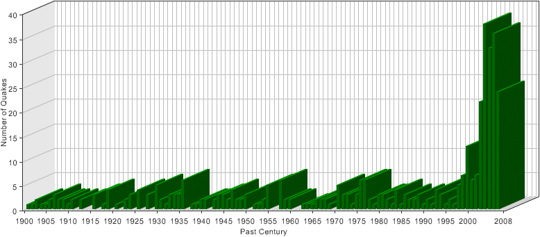
Numbers of world earthquakes per month
Source: research.dlindquist.com
Numbers of world earthquakes per year
Source: research.dlindquist.com
-
Comment by jorge namour on October 21, 2016 at 12:12pm
-
Euro-Med Seismological Centre (EMSC)
2 hrs ·
[BREAKING] #Japan: M6.2 #earthquake shakes Western Honshu.- JAPAN
Felt it? Please report ↓
Train services disrupted and Okayama airport closed, but no abnormalities were detected at the Shimane nuclear plant.
http://www.japantimes.co.jp/news/2016/10/21/national/strong-earthqu...
Homes damaged, power cut after strong quake rattles parts of western Honshu
A powerful earthquake with a preliminary magnitude of 6.6 shook parts of western Honshu early Friday afternoon, damaging homes and roads and cutting power to almost 40,000 households.
The Meteorological Agency said the earthquake occurred at 2:07 p.m. in central Tottori Prefecture, about 700 km west of Tokyo, at a depth of 10 km. It was followed by a weaker aftershock about 30 minutes later.
The agency said there was no danger of a tsunami from the inland temblor.
Two houses collapsed in the town of Hokuei, Tottori Prefecture, according to the local fire department. Roads were cracked and roof tiles laid strewn in the town.
In Kurayoshi in the prefecture, ATMs at some local banks temporarily went offline due to a power outage.
All up, the blackout affected nearly 40,000 households in Tottori Prefecture, according to Chugoku Electric Power Co.
Okayama City Fire Department said a woman was taken to hospital after she fell and injured herself.
West Japan Railway Co. temporarily suspended all services on the Sanyo Shinkansen Line between Shin-Osaka and Hakata stations.
https://www.facebook.com/SismoMundial/photos/a.806148329453999.1073...
# JAPAN The latest aftershocks of M 6.6 #Tottori registered with the JMA.
https://www.facebook.com/SismoMundial/posts/1178705152198313
World Seismology added 4 new photos.
2 hours ·
# GALLERY important local twitterers reported after earthquake damage #Tottori #Japon.
* The images were taken by @ kino331 @masteee @ytv_miyaneya_
-
-
www.emsc-csem.org/Earthquake/earthquake.php?id=537934
Magnitude mb 6.2 Region JAVA SEA Date time 2016-10-19 00:26:01.4 UTC Location 4.92 S ; 108.19 E Depth 629 km Distances 162 km N of Masjid Jamie Baitul Muttaqien, Indonesia / pop: 1,000,000 / local time: 07:26:01.4 2016-10-19
156 km N of Indramayu, Indonesia / pop: 124,000 / local time: 07:26:01.4 2016-10-19
2016-10-19 00:52:12.531min ago 42.81 N 13.23 E 9 3.0 CENTRAL ITALY F 2016-10-19 00:35:00.049min ago 36.40 N 7.59 E 10 3.2 NORTHERN ALGERIA 4 III 2016-10-19 00:26:01.458min ago 4.92 S 108.19 E 629 6.2 JAVA SEA 2016-10-19 00:16:30.01hr 07min ago 59.96 N 148.92 W 6 3.5 KENAI PENINSULA, ALASKA 11 IV 2016-10-19 00:08:46.81hr 15min ago 38.35 N 21.90 E 10 4.1 GREECE 2016-10-18 23:54:36.81hr 29min ago 37.05 N 28.36 E 5 2.0 WESTERN TURKEY 2016-10-18 23:09:52.92hr 14min ago 18.01 N 68.45 W 87 3.5 DOMINICAN REPUBLIC REGION 2016-10-18 22:54:12.62hr 29min ago 38.66 N 31.04 E 4 3.4 WESTERN TURKEY 2016-10-18 22:47:17.02hr 36min ago 60.33 N 140.65 W 0 2.0 SOUTHERN YUKON TERRITORY, CANADA 2016-10-18 22:35:59.02hr 48min ago 29.52 S 71.76 W 37 2.5 OFFSHORE COQUIMBO, CHILE 2016-10-18 22:26:41.32hr 57min ago 18.03 N 65.38 W 14 2.7 PUERTO RICO REGION 2 F 2016-10-18 22:09:07.73hr 15min ago 36.71 N 121.31 W 8 3.5 CENTRAL CALIFORNIA 4 IV 2016-10-18 22:08:13.93hr 15min ago 15.20 N 61.48 W 147 5.6 DOMINICA REGION, LEEWARD ISLANDS 2016-10-18 21:49:46.33hr 34min ago 38.67 N 31.05 E 5 2.7 WESTERN TURKEY 2016-10-18 21:36:49.83hr 47min ago 47.06 N 7.93 E 22 1.9 SWITZERLAND 2016-10-18 21:28:19.83hr 55min ago 40.14 N 31.57 E 4 2.1 WESTERN TURKEY 2016-10-18 21:26:52.83hr 57min ago 19.19 N 155.43 W 35 2.0 ISLAND OF HAWAII, HAWAII 2016-10-18 21:03:05.64hr 21min ago 39.18 N 29.14 E 7 2.1 WESTERN TURKEY 2016-10-18 20:55:37.24hr 28min ago 36.70 N 22.52 E 10 3.7 SOUTHERN GREECE F 2016-10-18 20:33:31.54hr 50min ago 38.69 N 31.06 E 5 3.8 WESTERN TURKEY 2016-10-18 20:21:58.45hr 02min ago 36.96 N 121.57 W 7 2.1 NORTHERN CALIFORNIA 182 IV 2016-10-18 20:13:54.55hr 10min ago 42.04 N 21.41 E 1 1.8 KOSOVO-SERBIA-FYROM BORDER REG. 2016-10-18 20:11:32.05hr 12min ago 25.63 S 70.47 W 72 4.0 ANTOFAGASTA, CHILE 2016-10-18 20:02:35.45hr 21min ago 39.18 N 29.14 E 6 2.3 WESTERN TURKEY 2016-10-18 19:36:03.95hr 48min ago 38.97 N 27.76 E 5 2.1 WESTERN TURKEY 2016-10-18 19:32:25.15hr 51min ago 38.93 N 27.72 E 9 2.5 WESTERN TURKEY 2016-10-18 19:24:14.05hr 59min ago 52.77 N 168.82 W 46 4.7 FOX ISLANDS, ALEUTIAN ISLANDS 2016-10-18 19:22:46.46hr 01min ago 38.57 N 43.70 E 30 4.1 EASTERN TURKEY 2016-10-18 19:02:11.46hr 21min ago 39.59 N 27.58 E 7 2.6 WESTERN TURKEY 2016-10-18 18:42:45.06hr 41min ago 38.67 N 26.61 E 12 2.3 NEAR THE COAST OF WESTERN TURKEY 2016-10-18 18:07:05.37hr 17min ago 18.94 N 155.55 W 39 2.1 HAWAII REGION, HAWAII 2016-10-18 17:36:01.87hr 48min ago 35.47 N 31.02 E 22 2.5 CYPRUS REGION 2016-10-18 17:15:54.08hr 08min ago 18.64 N 65.10 W 33 2.4 VIRGIN ISLANDS REGION 2016-10-18 16:47:46.98hr 36min ago 18.41 N 66.04 W 117 2.5 SAN JUAN URBAN AREA, PUERTO RICO 2016-10-18 16:47:00.08hr 37min ago 38.48 N 14.71 E 15 2.8 SICILY, ITALY 2016-10-18 16:42:13.28hr 41min ago 37.93 S 177.52 E 10 3.0 OFF E. COAST OF N. ISLAND, N.Z. 2016-10-18 16:36:51.68hr 47min ago 45.50 N 26.35 E 138 2.6 ROMANIA 2016-10-18 16:36:40.78hr 47min ago 23.35 S 179.95 W 533 6.0 SOUTH OF FIJI ISLANDS 2016-10-18 16:30:05.38hr 54min ago 18.28 N 65.19 W 106 2.3 PUERTO RICO REGION 2016-10-18 16:19:36.99hr 04min ago 39.27 N 28.43 E 7 2.5 WESTERN TURKEY F 2016-10-18 16:19:32.79hr 04min ago 39.52 N 9.17 W 8 3.0 PORTUGAL 2016-10-18 16:12:44.69hr 11min ago 40.49 N 30.00 E 2 2.3 WESTERN TURKEY 2016-10-18 15:55:58.39hr 28min ago 39.73 N 20.68 E 9 2.2 GREECE 2016-10-18 15:44:35.09hr 39min ago 30.52 S 72.07 W 16 3.4 OFFSHORE COQUIMBO, CHILE 2016-10-18 15:31:14.09hr 52min ago 6.80 N 73.14 W 148 2.4 NORTHERN COLOMBIA 2016-10-18 15:24:40.49hr 59min ago 37.74 N 110.53 W 8 2.9 UTAH 2016-10-18 15:08:35.710hr 15min ago 39.45 N 33.04 E 10 2.0 CENTRAL TURKEY 2016-10-18 14:40:50.510hr 43min ago 36.41 N 96.84 W 4 2.1 OKLAHOMA 2016-10-18 14:20:24.011hr 03min ago 34.76 S 71.77 W 41 2.9 LIBERTADOR O'HIGGINS, CHILE 2 F 2016-10-18 13:51:08.711hr 32min ago 41.87 N 22.16 E 1 2.5 FYR OF MACEDONIA
-
Comment by Poli on October 17, 2016 at 3:44pm
-
Magnitude Mw 6.8
Region NEW BRITAIN REGION, P.N.G.
Date time 2016-10-17 06:14:57.9 UTC
Depth 40 kmhttp://www.emsc-csem.org/Earthquake/earthquake.php?id=537490
-
-
MeteoWeb
EARTHQUAKES
HERE ARE STRONG SHOCK OF THE LAST 24 HOURS IN CENTRAL / EASTERN #MEDITERRANEAN
https://www.facebook.com/meteoweb/photos/a.268265436538012.73321.25...
An earthquake with a magnitude of 4.8 magnitude struck Black Sea on Oct. 15 and was felt in Istanbul. - TURKEY
http://www.hurriyetdailynews.com/48-quake-shakes-black-sea.aspx?pag...
An earthquake with a magnitude of 4.8 magnitude struck Black Sea on Oct. 15 and was felt in Istanbul.
he epicenter of the quake, which took place at 11:18 a.m. was 11.4 kilometers below the Earth’s surface and occurred 192 kilometers northeast of Istanbul.
Some local residents in the Kandıra district of the northwestern province of Kocaeli reportedly went outside their residences after panicking during the moments of the quake.
Meanwhile, the 4.8 magnitude quake was also felt in Istanbul.
http://www.emsc-csem.org/Earthquake/?view=1 NOT AVAILABLE
http://geofon.gfz-potsdam.de/eqinfo/list.php GEOFON
2016-10-16 00:48:20 5.1 39.79°N 20.56°E 28 A Greece-Albania Border Region
2016-10-16 00:41:17 4.8 39.79°N 20.53°E 24 A Greece-Albania Border Region
2016-10-16 00:10:03 4.7 39.82°N 20.53°E 46 C Greece-Albania Border Region
2016-10-15 23:07:01 4.4 39.69°N 20.63°E 23 C Greece-Albania Border Region
Region: Greece-Albania Border Region
Mw Beach Ball
Time: 2016-10-15 20:14:52.2 UTC
Magnitude: 5.4 (Mw)
Epicenter: 20.54°E 39.82°N
Depth: 33 km
Status: C - confirmed http://geofon.gfz-potsdam.de/eqinfo/event.php?id=gfz2016uhsyhttps://translate.google.com/translate?sl=it&tl=en&js=y&...
Strong earthquake in Greece, so scared in Salento: People in the street in Lecce, Brindisi and Taranto [MAPS]
Earthquake, today many strong shocks between Greece and Turkey: Fear from Istanbul to Crete [DATA]Region: Black Sea
Mw Beach Ball
Time: 2016-10-15 08:18:33.9 UTC
Magnitude: 4.8 (Mw)
Epicenter: 30.66°E 42.20°N
Depth: 10 km
Status: M - manually revised http://geofon.gfz-potsdam.de/eqinfo/event.php?id=gfz2016ugviF-E Region: New Britain Region, P.N.G.
Mw Beach Ball
Time: 2016-10-15 08:03:38.9 UTC
Magnitude: 6.3 (Mw)
Epicenter: 150.34°E 4.28°S
Depth: 453 km
Status: C - confirmed http://geofon.gfz-potsdam.de/eqinfo/event.php?id=gfz2016uguv
-
-
www.emsc-csem.org/Earthquake/earthquake.php?id=536567
Magnitude Mw 5.8 Region NEW IRELAND REGION, P.N.G. Date time 2016-10-12 03:21:23.6 UTC Location 5.32 S ; 153.48 E Depth 10 km Distances 832 km NE of Port Moresby, Papua New Guinea / pop: 284,000 / local time: 13:21:23.6 2016-10-12
172 km SE of Kokopo, Papua New Guinea / pop: 26,300 / local time: 13:21:23.6 2016-10-12
Source parameters reviewed by a seismologist
2016-10-12 11:29:38.019min ago 46.23 N 6.99 E -1 1.5 SWITZERLAND 2016-10-12 10:39:13.51hr 09min ago 10.71 N 144.81 E 10 5.1 SOUTH OF MARIANA ISLANDS 116 IV 2016-10-12 09:39:02.42hr 09min ago 42.01 N 21.48 E 6 2.6 KOSOVO-SERBIA-FYROM BORDER REG. 2016-10-12 08:51:05.42hr 57min ago 37.45 N 38.80 E 5 2.3 EASTERN TURKEY 2016-10-12 08:29:30.03hr 19min ago 27.66 N 85.95 E 10 4.1 NEPAL 2016-10-12 08:24:44.33hr 24min ago 51.13 N 177.53 W 40 4.3 ANDREANOF ISLANDS, ALEUTIAN IS. 2016-10-12 08:12:36.93hr 36min ago 39.32 N 32.79 E 8 2.0 CENTRAL TURKEY 2016-10-12 08:10:05.23hr 38min ago 40.97 N 22.74 E 2 2.7 GREECE 2016-10-12 07:49:39.03hr 59min ago 61.74 N 150.39 W 50 2.6 SOUTHERN ALASKA 2016-10-12 07:39:17.04hr 09min ago 19.69 S 71.04 W 37 3.4 OFF COAST OF TARAPACA, CHILE 2016-10-12 07:32:34.74hr 16min ago 36.49 N 98.81 W 6 3.1 OKLAHOMA 2016-10-12 05:41:53.56hr 06min ago 35.96 N 23.26 E 2 3.0 CRETE, GREECE 2016-10-12 05:03:00.06hr 45min ago 61.77 N 152.05 W 105 2.5 SOUTHERN ALASKA 2016-10-12 05:00:04.96hr 48min ago 39.66 N 25.62 E 15 1.9 AEGEAN SEA 2016-10-12 04:33:03.27hr 15min ago 41.95 N 20.10 E 19 2.4 ALBANIA 2016-10-12 04:16:23.77hr 32min ago 20.93 S 178.52 W 581 5.4 FIJI REGION 2016-10-12 04:13:07.07hr 35min ago 62.34 N 149.20 W 188 2.0 CENTRAL ALASKA 2016-10-12 04:06:53.07hr 41min ago 5.35 S 153.47 E 40 4.9 NEW IRELAND REGION, P.N.G. 2016-10-12 04:06:48.77hr 42min ago 38.77 N 122.72 W 2 2.2 NORTHERN CALIFORNIA 2016-10-12 04:01:25.17hr 47min ago 13.42 N 50.71 E 10 4.3 GULF OF ADEN 2016-10-12 03:57:31.87hr 51min ago 11.53 S 165.22 E 10 4.7 SANTA CRUZ ISLANDS 2016-10-12 03:21:23.68hr 27min ago 5.32 S 153.48 E 10 5.8 NEW IRELAND REGION, P.N.G. 2016-10-12 03:16:19.08hr 32min ago 65.67 N 145.18 W 0 2.2 NORTHERN ALASKA 2016-10-12 03:16:01.48hr 32min ago 8.36 N 125.99 E 20 4.9 MINDANAO, PHILIPPINES 2016-10-12 03:06:26.68hr 42min ago 37.43 N 26.82 E 13 2.0 DODECANESE ISLANDS, GREECE 2016-10-12 03:03:01.18hr 45min ago 17.88 N 65.66 W 10 2.1 PUERTO RICO REGION 2016-10-12 03:00:50.08hr 48min ago 42.15 N 7.76 W 15 2.9 SPAIN 2016-10-12 02:57:45.08hr 51min ago 65.68 N 145.23 W 15 3.9 NORTHERN ALASKA 2016-10-12 02:53:04.58hr 55min ago 35.61 N 36.59 E 20 3.2 SYRIA 2016-10-12 02:47:33.69hr 01min ago 18.67 N 65.91 W 37 2.9 PUERTO RICO REGION 2016-10-12 02:36:59.39hr 11min ago 36.15 N 29.65 E 6 2.1 WESTERN TURKEY 2016-10-12 02:23:47.69hr 25min ago 36.47 N 28.75 E 5 1.9 DODECANESE IS.-TURKEY BORDER REG 2016-10-12 02:08:16.59hr 40min ago 42.69 N 13.26 E 13 2.5 CENTRAL ITALY 1 F 2016-10-12 01:59:21.79hr 49min ago 30.70 S 71.51 W 41 4.7 COQUIMBO, CHILE 2016-10-12 01:40:10.410hr 08min ago 32.94 N 117.53 W 14 2.1 GULF OF SANTA CATALINA, CALIF. 2 F 2016-10-12 01:39:26.810hr 09min ago 13.63 N 120.88 E 147 5.3 MINDORO, PHILIPPINES 2016-10-12 01:32:35.010hr 16min ago 60.18 N 141.39 W 3 2.1 SOUTHERN ALASKA 2016-10-12 01:26:41.010hr 22min ago 39.35 N 29.90 W 10 2.5 AZORES ISLANDS, PORTUGAL 2016-10-12 01:14:51.310hr 33min ago 40.62 N 28.96 E 6 1.6 WESTERN TURKEY 2016-10-12 01:10:13.010hr 38min ago 39.48 N 29.72 W 63 2.9 AZORES ISLANDS, PORTUGAL 2016-10-12 01:00:08.710hr 48min ago 37.43 N 26.85 E 7 2.1 DODECANESE ISLANDS, GREECE 2016-10-12 00:56:55.010hr 51min ago 38.89 N 44.55 E 5 2.2 TURKEY-IRAN BORDER REGION 2016-10-12 00:22:36.011hr 26min ago 60.97 N 145.54 W 15 2.4 SOUTHERN ALASKA 2016-10-11 23:59:34.611hr 49min ago 17.96 N 66.88 W 15 2.5 PUERTO RICO 2016-10-11 23:49:41.111hr 59min ago 40.66 N 28.86 E 15 1.8 WESTERN TURKEY 2016-10-11 23:49:07.511hr 59min ago 17.96 N 66.89 W 14 2.4 PUERTO RICO 2016-10-11 23:47:45.7 40.60 N 28.96 E 6 1.9 WESTERN TURKEY 2016-10-11 23:44:18.7 40.62 N 28.95 E 6 2.0 WESTERN TURKEY 2016-10-11 23:42:43.6 40.61 N 28.95 E 5 3.1 WESTERN TURKEY 2016-10-11 23:41:32.2 40.60 N 28.94 E 20 2.3 WESTERN TURKEY
-
-
www.emsc-csem.org/Earthquake/earthquake.php?id=536094
Source parameters not yet reviewed by a seismologist
2016-10-09 14:41:40.21hr 07min ago 40.54 N 23.62 E 5 2.2 GREECE 2016-10-09 14:18:37.61hr 30min ago 45.07 N 127.81 W 10 4.3 OFF COAST OF OREGON 2016-10-09 14:16:02.01hr 33min ago 6.84 N 73.19 W 144 3.5 NORTHERN COLOMBIA 2016-10-09 13:59:23.81hr 49min ago 39.01 N 27.70 E 8 1.9 WESTERN TURKEY 2016-10-09 13:44:27.02hr 04min ago 19.47 N 154.72 W 12 3.8 HAWAII REGION, HAWAII 2016-10-09 13:31:22.42hr 18min ago 36.72 N 28.22 E 64 1.9 DODECANESE IS.-TURKEY BORDER REG 2016-10-09 13:15:54.22hr 33min ago 38.85 N 27.70 E 1 2.0 WESTERN TURKEY 2016-10-09 13:13:07.72hr 36min ago 40.10 N 40.93 E 11 2.8 EASTERN TURKEY 2016-10-09 13:02:29.12hr 46min ago 17.89 N 66.64 W 6 2.2 PUERTO RICO REGION 2016-10-09 12:57:26.02hr 51min ago 58.73 N 141.55 W 47 2.1 OFF COAST OF SOUTHEASTERN ALASKA 2016-10-09 12:48:25.13hr 00min ago 62.38 N 2.35 E 2 4.8 NORWEGIAN SEA 2016-10-09 12:23:05.33hr 26min ago 36.44 N 96.89 W 5 3.8 OKLAHOMA 2 F 2016-10-09 12:04:11.43hr 45min ago 38.19 N 20.21 E 5 4.0 GREECE 2016-10-09 11:58:04.83hr 51min ago 37.25 N 27.87 E 26 1.7 WESTERN TURKEY 2016-10-09 11:27:10.34hr 22min ago 39.41 N 32.16 E 10 1.7 CENTRAL TURKEY 2016-10-09 11:04:29.44hr 44min ago 18.93 N 66.73 W 37 2.7 PUERTO RICO REGION 2016-10-09 11:02:13.54hr 47min ago 36.52 N 28.74 E 20 2.0 DODECANESE IS.-TURKEY BORDER REG 2016-10-09 11:01:21.74hr 48min ago 18.71 N 64.24 W 61 2.2 VIRGIN ISLANDS REGION 2016-10-09 10:59:52.94hr 49min ago 49.86 N 91.17 E 10 3.9 WESTERN MONGOLIA 2016-10-09 10:59:36.34hr 49min ago 17.88 N 66.64 W 12 2.4 PUERTO RICO REGION 2016-10-09 10:56:46.04hr 52min ago 60.16 N 151.32 W 22 2.7 KENAI PENINSULA, ALASKA 2016-10-09 10:55:50.04hr 53min ago 6.82 N 73.15 W 148 3.1 NORTHERN COLOMBIA 2016-10-09 10:52:24.44hr 56min ago 39.01 N 27.70 E 7 2.7 WESTERN TURKEY 2016-10-09 10:51:14.84hr 58min ago 39.01 N 27.71 E 7 2.7 WESTERN TURKEY 1 F 2016-10-09 10:39:19.45hr 10min ago 9.05 N 125.61 E 59 4.8 MINDANAO, PHILIPPINES 2016-10-09 10:33:02.65hr 16min ago 42.63 N 13.21 E 11 2.8 CENTRAL ITALY 2016-10-09 10:17:50.05hr 31min ago 20.72 S 69.13 W 110 2.9 TARAPACA, CHILE 2016-10-09 10:05:57.95hr 43min ago 36.51 N 33.82 E 12 1.6 CENTRAL TURKEY 2016-10-09 09:29:40.86hr 19min ago 17.84 N 67.01 W 6 2.0 PUERTO RICO REGION 2016-10-09 09:19:43.06hr 29min ago 20.16 S 69.24 W 94 3.3 TARAPACA, CHILE 2016-10-09 09:06:44.46hr 42min ago 37.17 N 27.86 E 5 1.8 WESTERN TURKEY 2016-10-09 09:03:51.76hr 45min ago 37.15 N 27.87 E 5 1.7 WESTERN TURKEY 2016-10-09 08:29:53.77hr 19min ago 45.79 N 15.42 E 1 1.5 CROATIA 2016-10-09 08:29:17.07hr 20min ago 58.15 N 153.74 W 56 3.3 KODIAK ISLAND REGION, ALASKA 2016-10-09 08:18:49.87hr 30min ago 37.85 N 29.19 E 5 2.5 WESTERN TURKEY 2016-10-09 08:13:30.07hr 35min ago 8.71 N 83.33 W 15 4.3 COSTA RICA 2016-10-09 07:58:52.37hr 50min ago 37.51 N 35.57 E 5 2.0 CENTRAL TURKEY 2016-10-09 07:49:30.37hr 59min ago 18.53 N 64.27 W 5 2.3 VIRGIN ISLANDS REGION 2016-10-09 07:26:22.08hr 23min ago 60.52 N 144.29 W 0 2.0 SOUTHERN ALASKA 2016-10-09 07:04:14.68hr 45min ago 37.78 N 21.87 E 1 2.1 SOUTHERN GREECE 2016-10-09 07:00:33.98hr 48min ago 17.88 N 66.67 W 10 2.3 PUERTO RICO REGION 2016-10-09 06:45:43.69hr 03min ago 33.23 N 116.75 W 9 2.2 SOUTHERN CALIFORNIA 2016-10-09 06:41:26.29hr 07min ago 36.52 N 29.13 E 19 1.7 WESTERN TURKEY 2016-10-09 06:33:14.19hr 16min ago 42.85 N 85.74 E 1 4.1 NORTHERN XINJIANG, CHINA 2016-10-09 06:27:51.99hr 21min ago 37.20 N 28.14 E 5 1.6 WESTERN TURKEY 2016-10-09 06:21:00.59hr 28min ago 39.00 N 27.71 E 12 4.0 WESTERN TURKEY F 2016-10-09 06:07:00.09hr 42min ago 29.86 S 71.57 W 33 3.4 OFFSHORE COQUIMBO, CHILE 2016-10-09 05:56:04.99hr 53min ago 38.91 N 31.46 E 9 1.8 WESTERN TURKEY

-
-
Euro-Med Seismological Centre (EMSC)
September 30 at 5:39pmThe California Office of Emergency Services has issued an earthquake advisory for Southern California.
http://www.keyt.com/news/earthquake-advisory-for-parts-of-southern-...
Posted: Sep 29, 2016
Earthquake advisory for parts of Southern Califonia
Increased probability of moderate earthquakeThe California Office of Emergency Services has issued an earthquake advisory for Southern California. Alerting several counties that the probability of a major earthquake is more likely this week.
The earthquake advisory is in effect for the following counties: Ventura, San Diego, San Bernardino, Riverside, Orange, Los Angeles, Kern and Imperial.
The advisory was issued following a series of small magnitude earthquakes near Bombay Beach, Salton Sea.
“The scientist rated that there was an increased probability of up to 1% so a slight increase. Really at the end of the day it is a great reminder to us that we live in earthquake country and that earthquakes can strike, suddenly, violently and with no warning so everyones best bet is to be prepared prior to,” said Kevin McGowan with the Ventura County Office of Emergency Services.
While the Operation of Emergency Services prepares there are also a few things you can do as well.
“Drop, cover, and hold when an earthquake occurs. Prior to, have a disaster kit. Definitely an important thing 3-days at a minimum worth of water and food, extra clothing is important. If you have prescription medicine, definitely have prescription medicine on hand,” said McGowan. CONTINUE...
-----------------------------------------
https://www.facebook.com/SismoMundial/photos/a.806148329453999.1073...
World Seismology
· Yesterday · Edited ·[19:06 HL] ⚠ #Now unusually strong M5.0 earthquake on the coast of Cuba with a depth of 10 km. #temblor #USGS
M 5.7 - LUZON, PHILIPPINES - 2016-10-02 13:40:10 UTC
http://earthquake.usgs.gov/earthquakes/eventpage/us10006ui7#executiveM 5.3 - PAKISTAN - 2016-10-01 08:04:38 UTC
http://www.emsc-csem.org/Earthquake/earthquake.php?id=534540Magnitude mb 4.9
Region SOUTHWEST INDIAN RIDGE
Date time 2016-10-02 12:51:51.4 UTC
Location 29.19 S ; 61.02 E
Depth 10 km http://www.emsc-csem.org/Earthquake/earthquake.php?id=5347282016-10-01 ML 3.6 FRANCE
http://www.emsc-csem.org/Earthquake/Testimonies/comments.php?id=534651
----------------------------------------Watch: Steam visible above Mt Ruapehu - NZ HERALD NEW ZEALAND
http://www.nzherald.co.nz/nz/news/article.cfm?c_id=1&objectid=1...
30 SEPTEMBER 2016. Steam plumes have been seen above Mt Ruapehu this morning, as the crater lake has heated up close to its natural peak, GNS Science says.
The lake began heating early this month, rising from 13C to its current level of about 37C. CONTINUE...
-
-
Quake Hunter Australia
3 hrs ·Hey guys. Had reports of a shake near Gladstone in Queensland.
We can not find any data to suggest a quake occurred.http://www.couriermail.com.au/news/queensland/queenslanders-reporti...
Queenslanders reporting seeing bright lights in sky followed by tremor
SEPTEMBER 26 2016UNDREDS of Queenslanders have reported seeing “a flash of light” in the sky, following by a “tremor”.
Police received multiple calls from residents in the Gladstone area reporting their houses shaking in what was initially believed to be an earthquake.
But Geoscience Australia has since officially ruled out an earthquake.
There were reports as far south as the Sunshine Coast, with one Nambour man saying he heard a loud noise and a flash of light just before 8.30pm
Lanky Jones said the light was very bright and it appeared as though an object was burning up in the sky.
“It sounded a lot like a sonic boom, which would make sense if something was travelling too fast into the atmosphere,” he said.
“I don’t know what what it was, whether a meteorite or piece of space junk, I didn’t feel the tremor but the sound suggests something came down to earth.
“It’s definitely not something you see every day.”
M 4.3 - 6km SSE of Bombay Beach, CA FELT EMSC
http://earthquake.usgs.gov/earthquakes/eventpage/ci37700296#executive
2.5
7km SSE of Bombay Beach, CA
2016-09-26 14:35:45 (UTC)
2.0 km
3.0
2km ESE of Bombay Beach, CA
2016-09-26 14:33:44 (UTC)
14.8 kmM 6.0 - 113km NNE of Nago, Japan
http://earthquake.usgs.gov/earthquakes/eventpage/us10006sp7#executive4.8
169km NE of Gisborne, New Zealand
2016-09-26 05:17:25 (UTC)
10.0 km http://earthquake.usgs.gov/earthquakes/eventpage/us10006sp6#executive5.0
50km SSW of Shizunai, Japan
2016-09-26 02:24:38 (UTC)
65.0 km
http://earthquake.usgs.gov/earthquakes/eventpage/us10006sn0#executiveM 2.7 - WESTERN MONTANA - 2016-09-26 08:50:27 UTC
http://www.emsc-csem.org/Earthquake/earthquake.php?id=533350M 4.6 - OFFSHORE O'HIGGINS, CHILE - 2016-09-26 02:57:39 UTC FELT
http://www.emsc-csem.org/Earthquake/earthquake.php?id=533263M 3.8 - WESTERN TURKEY - 2016-09-25 20:51:20 UTC
http://www.emsc-csem.org/Earthquake/earthquake.php?id=533205M 5.1 - SOUTH OF KERMADEC ISLANDS - 2016-09-24 23:52:02 UTC
http://www.emsc-csem.org/Earthquake/earthquake.php?id=533055
M 4.9 - SOUTH OF KERMADEC ISLANDS - 2016-09-24 23:42:49 UTC
M 5.3 - SOUTH OF KERMADEC ISLANDS - 2016-09-24 23:27:18 UTC
M 6.7 - FIJI REGION - 2016-09-24 21:28:40 UTC
http://www.emsc-csem.org/Earthquake/earthquake.php?id=533012M 6.4 - TONGA - 2016-09-24 21:07:12 UTC
http://www.emsc-csem.org/Earthquake/earthquake.php?id=5330042016-09-24 11:09:42.7 1.84 S 140.63 E 10 5.6 PAPUA REGION, INDONESIA
2016-09-24 11:04:29.2 1.91 S 140.69 E 10 5.9 PAPUA REGION, INDONESIA
© 2025 Created by 0nin2migqvl32.
Powered by
![]()
You need to be a member of Earth Changes and the Pole Shift to add comments!
Join Earth Changes and the Pole Shift