Category 5 – Strongest Hurricane on Record So Far North and East in the Atlantic Ocean
Sep 30, 2019
Lorenzo has now weakened but is still a danger to the Azores Tuesday night or early Wednesday, while Lorenzo’s post-tropical remnant may end up in western Europe later in the week.
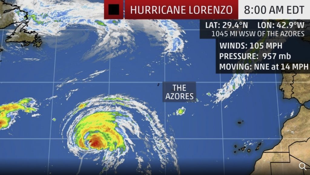
Hurricane Lorenzo Now
Hurricane and tropical storm watches have been issued for the Azores ahead of Hurricane Lorenzo’s close swipe by the northeast Atlantic islands early this week.
Lorenzo has weakened from its brief stint as a Category 5 hurricane over the weekend, smashing a record for the easternmost Atlantic hurricane to attain such a strong intensity.
But Lorenzo should still bring a burst of strong winds, locally heavy rain and pounding surf to the Azores.
Lorenzo’s Record Eastern Atlantic Intensity
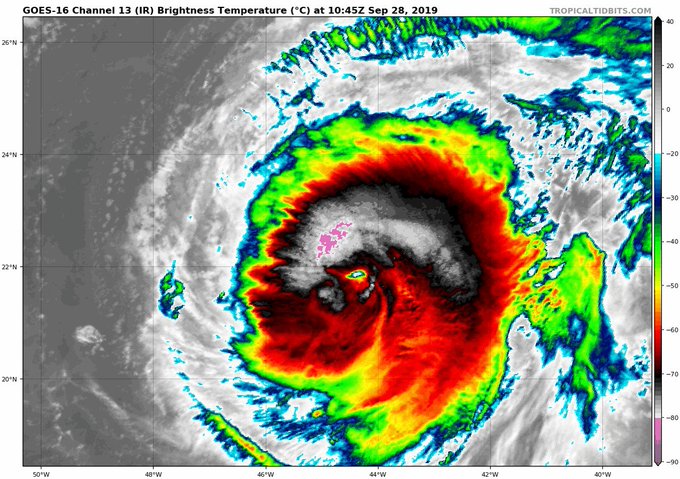
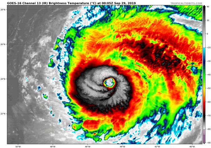
Lorenzo rapidly deepened Saturday from Category 3 status with estimated maximum sustained winds of 115 mph at 11 a.m. EDT to Category 5 status with winds of 160 mph just 12 hours later.
This is by far the farthest east in the Atlantic Ocean any of the previous 35 Category 5 hurricanes have occurred in records dating to the 1920s.
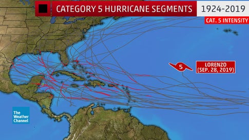 Hurricane Lorenzo records: Lorenzo became a Category 5 hurricane on Sept. 28, 2019, farther east than any previous Category 5 Atlantic hurricane on record.
National Hurricane Center forecaster Eric Blake noted Lorenzo became a Category 5 hurricane almost 650 miles farther east than the previous easternmost Category 5 hurricane, Hugo in 1989.
Lorenzo also had the lowest pressure for a hurricane east of 50 degrees west longitude on record Saturday evening.
#Lorenzo's current central pressure of 925 hPa is the lowest by any Atlantic #hurricane east of 50°W on record. Prior record was 933 hPa by Edouard (1996), Gert (1999) and Igor (2010).
Moreover, it has been a major hurricane for the longest period of time east of 45 degrees west longitude on record.
#Lorenzo has now been a major (Category 3+) #hurricane east of 45°W for 2 days - the most major hurricane days by an Atlantic hurricane east of 45°W on record. This breaks the old Atlantic record set by Hurricane Carrie of 1.75 days set in 1957.
Lorenzo was the second Category 5 hurricane of the 2019 Atlantic hurricane season and the sixth such top-end hurricane to form in the Atlantic Basin in a little less than three years, following Matthew, Irma, Maria, Michael and Dorian.
2019 is the 7th Atlantic #hurricane season on record with at least 2 Category 5 hurricanes. Other years are: 1932, 1933, 1961, 2005, 2007, and 2017. 2019's Category 5 hurricanes are #Dorian and #Lorenzo.
Lorenzo Forecast
Lorenzo has since weakened from its lofty perch, but it is forecast to pass near the Azores Tuesday night or Wednesday as a still formidabl hurricane.
The National Hurricane Center (NHC) mentioned Lorenzo’s wind field is large, increasing the chances it may impact the group of Portuguese islands about 900 miles west of Portugal.
A hurricane watch has been issued in the Azores for Flores, Corvo, Faial, Pico, Sao Jorge, Graciosa and Terceira. That means hurricane conditions (74-plus mph winds) are possible within 48 hours.
There is also a tropical storm watch posted for Sao Miguel and Santa Maria. That means tropical storm conditions (39-plus mph winds) are possible within 48 hours.
Heavy rain from Lorenzo may also lead to life-threatening flash flooding in the Azores late Tuesday into Wednesday.

Hurricane Lorenzo forecast for the next few days: Azores and then UK.
After it passes the Azores, it will lose its tropical characteristics but still be a powerful storm. What remains of Lorenzo may bring a blast of strong winds, rain and pounding surf to Ireland and the United Kingdom later this week.
From the History Books
According to NOAA’s historical database, only seven Category 2 or stronger hurricanes have tracked within 200 nautical miles of the Azores in records dating to the mid-19th century.
Ophelia passed south the Azores as a Category 3 hurricane in mid-October 2017 and produced tropical-storm-force winds (39-plus mph), downing a fe trees and triggering some minor flooding, according to the NHC’s final report.
A September 1926 Category 2 hurricane with estimated winds of 105 mph tracked over the island of São Miguel.
As meteorologist Yaakov Cantor mentioned last Thursday, there have been a number of strange eastern Atlantic hurricanes and tropical storms in recent years, including Leslie almost making it to Portugal as a hurricane in 2018 and a bizarre January strike from Hurricane Alex in the Azores.
The past several years have seen a number of Atl hurricanes unusually far NE- Vince 2005 hit Portugal as a TD, Gordon 2006 became ET just W of Portugal, Alex 2016 hit the Azores, Ophelia 2017 became ET just before hitting UK, Leslie 2018 became ET just before hitting Portugal
Lorenzo’s large circulation is generating swells over much of the North Atlantic Ocean that will lead to dangerous surf at the beaches of the East Coast of the United States, many Caribbean islands, the Bahamas, Bermuda, western Europe, Atlantic Canada and even western Africa over the next few days.
Lorenzo’s Other Records
Even before becoming a Category 5, Lorenzo was a historic storm.
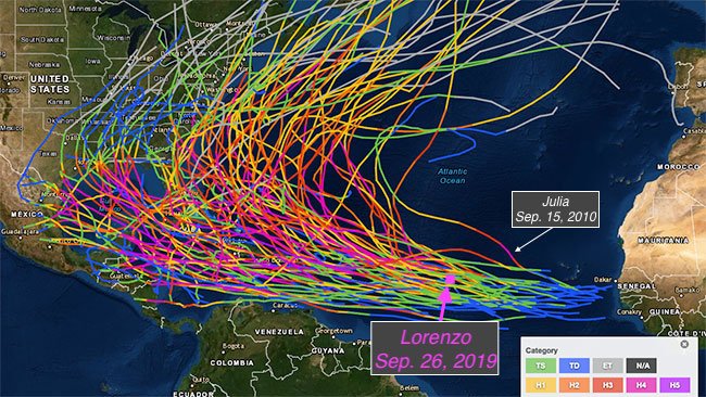
When Lorenzo first became a Category 4 hurricane, it was also an outlier, particularly when considering only those that became Category 4 hurricanes from Sept. 26 through the end of the season:
Jonathan Erdman ✔@wxjerdmanThat map has 1950-2017 Atlantic Basin Cat. 4+ hurricanes. Adding 2018's Florence & Michael, and 2019's Dorian and #Lorenzo, that makes 103 Cat. 4+ since 1950. Only 1 of those became that strong farther east than Lorenzo did today. https://twitter.com/weatherchannel/status/1177290056744218625 …
The Weather Channel ✔@weatherchannel#Lorenzo is a Cat. 4 #hurricane. That's impressive enough. Where it became a Cat. 4, though, is very rare. https://weather.com/safety/hurricane/news/2019-09-26-hurricane-lore...;…
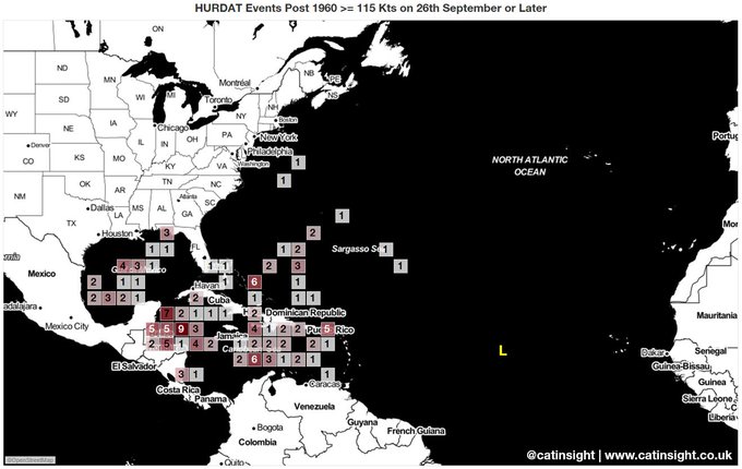
And if you look at the data and restrict it to a) satellite era and b) on or after 26th September, Lorenzo looks freakish.
September 2010’s Hurricane Julia was the only other hurricane on record to intensify to Category 4 status farther east in the Atlantic Ocean than Lorenzo. But Julia’s estimated winds peaked at 140 mph, slightly lower than Lorenzo.
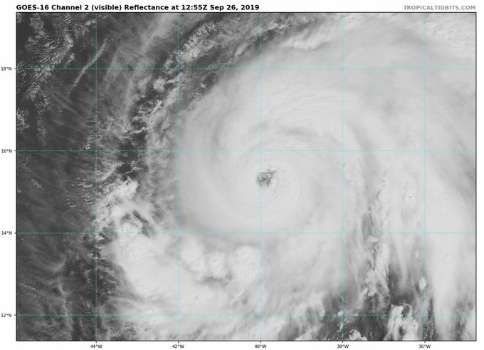
#Lorenzo is now a Category 4 #hurricane - the only Atlantic hurricane on record to reach Category 4 intensity farther east in the Atlantic on record is Julia in 2010.
Even in the heart of hurricane season, tropical waves moving off the coast of western Africa usually take some time to mushroom into intense hurricanes.
This is often due to intrusions of dry air, known as Saharan air layers, moving off Africa’s Sahara Desert. Fledgling tropical disturbances need warm, moist air to intensify, so battling these intrusions can prevent intensification or even spell doom in the eastern Atlantic Ocean.
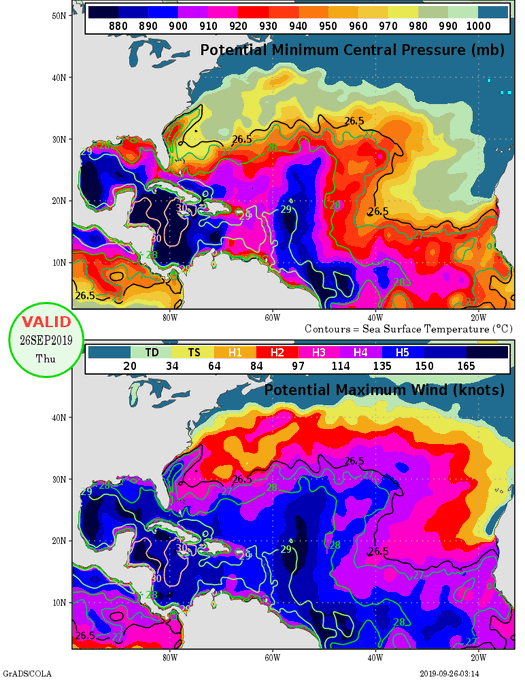
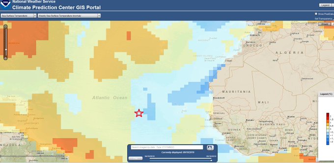
In Lorenzo’s case, that wasn’t a big problem. A lack of shearing winds, typically warm ocean water and moist air allowed Lorenzo to rapidly intensify so far east.
In this particular case, where #Lorenzo reached major #hurricane strength (highlighted by red star) had near average sea surface temperatures. Very low vertical wind shear and high mid-level moisture likely primarily drivers of intensification this far east.
Lorenzo strengthened from a tropical storm last Tuesday into a hurricane by Wednesday, before reaching Category 4 hurricane strength by late Thursday morning.
If I was living in the Azores, I would really have a plan for this Hurricane Lorenzo. The storm will be intense… That’s the least we can say!
Source: https://strangesounds.org/2019/09/hurricane-lorenzo-becomes-a-categ...
SEARCH PS Ning or Zetatalk
Nancy Lieder, Emissary of the Zetas.
https://poleshift.ning.com/xn/detail/3863141:Comment:1168188
Awakening to the Alien Presence ZetaTalk
The truth will likely never to be known to the public but be washed away in the Nibiru panic soon to engulf the world.
The Worst of the Cover-Up
https://poleshift.ning.com/profiles/blogs/the-worst-of-the-cover-up
Main Establishment Lies
https://poleshift.ning.com/profiles/blogs/main-establishment-lies
Donate
© 2025 Created by 0nin2migqvl32.
Powered by
![]()





You need to be a member of Earth Changes and the Pole Shift to add comments!
Join Earth Changes and the Pole Shift