7 of 10 TILTING & SINKING ZetaTalk Accuracy! Fiji worst ever floods!
Map of maximum extent inundation. Not all areas were inundated at the same time or for the whole time. This map shows the sum of all flooded areas; in Sunda region (Myanmar, Thailand, Cambodia, Vietnam, China, Philippines, Malaysia, Southern Indonesia edge, Singapore, Brunei) since 2010 and in South Asia since 2007 (India, Pakistan, Bangladesh, Nepal). Red it's extent of floodwater, now dry
Red 2007; Orange 2008; Purple 2009; Yellow 2012; Green 2013; The map shows the sum of all flooded areas.
ZetaTalk Prediction:
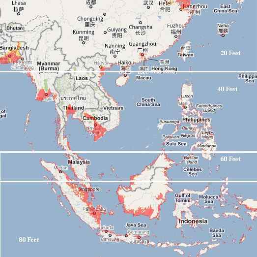 We have spoken previously of the areas to be affected by the bending of the tongue holding Indonesia, but can now give more specifics. Draw a line from the city of Hangzhou directly east, and consider this horizontal line the point of bend. This does not mean that points north can rest easy, as when the tongue bends down water from various sides will rush in to fill the void, and these waters will have a rebound in the form of tsunami which can race northward at a height of 20-30 feet. The southern coast of China was likewise warned that they could experience loss of elevation. How much will their coastline drop, that they needed this warning from the Hangzhou UFO? This coastline, in general, can anticipate losing 20 feet in elevation, which will likewise afflict Taiwan though Taiwan is high land and will not be as devastated.
Thought the tipping of the Philippine Plate at first gives the islands of the Philippines some relief, as the subduction of the plate is pushing under them, as the bending of the tongue holding Indonesia progresses, they too find an astonishing loss of sea level. However, other than some small islands and the direct coastline, little of the Philippines will be affected by this rise in sea level, and safety can be gained if the coastal residents head for the hills at the first sign of sinking. Tsunami will affect the Philippines, to a potential height of 40 feet, so a prompt evacuation to be at least 20 miles inland is necessary. If the coast of southern China will lose 20 feet in elevation, the Philippines will ultimately lose twice that much, to a total loss of 40 feet in elevation. Due to the tilting of the Indo-Australia Plate, Bangladesh gains temporary relief from the steady sinking it has experienced the past few years. And the tsunami likely to race northward will not come their way because the waters from the Bay of Bengal will be rushing into the South China Sea, and there clashing to push north. If the loss of 40 feet in elevation is not devastating to the Philippines, it is to the coastline of southern Burma, Tailand, and Cambodia, which have vast areas that will suddenly and permanently be flooded.
It is the southern tip of the tongue which is utterly devastated. Draw a line just north of the Malaysia border and over the top of Borneo. The land on the tongue from this point south will double its elevation loss, so that Java and the islands bordering the Banda Sea will find they have lost a full 80 feet in elevation, sinking many coastal cities and small islands out of sight. Singapore will be awash, its streets hopelessly inundated. Vast areas of the northern coastline of Sumatra and the southern coastline of Borneo will likewise be inundated. And if having the sea rush in were not horrific enough, the sudden drop in elevation will bring with it water from the Indian Ocean and the Philippine Sea which will create turmoil, unpredictable waves that clash and boil. There is no predictor indicating that the bend and drop are about to happen that we could point to. There are, as we mentioned there would be, indicators of the direction that the plates are being pushed, as Jakarta has been sinking, Pakistan sinking, and the Coral Sea floor rising. We are telling you your coastlines are not safe, and the rest is up to you!
ZetaTalk: Indonesia loss elevation
Fiji
ZetaTalk Prediction:
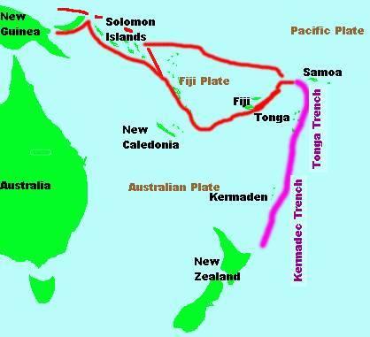 The islands at the plate borders in this region do not do well during the plate adjustments to come. The primary devastation will come during the hour of the pole shift, but the devastation has started during the 7 of 10 adjustments. Samoa rides on the Pacific Plate, which is pushing under the eastern edge of the Indo-Australian Plate, and as this process continues and accelerates, approaching the pole shift, will virtually disappear. The Solomon Islands do not fare much better, for the same reasons. Tonga and New Caledonia ride high. The little Fiji Plate, as the recent sinking indicates, will be a loser, pushed down into the notch as the Pacific Plate presses ever westward.
4 March, 2012. Sinking feeling
THE effects of climate change and rising sea level have seen a daily overflow of seawater into the village of Vunidogoloa in Cakaudrove.
In fact, the 40 households have become used to having seawater under their homes or in the compound during high tide. The seawater enters the village through drains within compounds."It doesn't happen only during heavy rain or natural disaster when the waves come into the village. It happens everyday when there is high tide and we are getting worried," said villager Samuela Banicau.
"I was born in this village and this is the first time I have seen seawater entering the village everyday during high tides." Mr Banicau said the village used to sit at least three metres above sea level when he was a child.
"Today the village is at the same level with the sea and when we sit in our houses, we just look straight out to sea which never used to happen.
"Before, we used to look down at the sea and I guess what's happening today is all part of climate change," Mr Banicau said. Government has already prepared the new village site about two kilometres inland from the current site.
When The Fiji Times visited the village last week, little ponds of seawater could be seen on the village green.
Mr Banicau said the villagers have become used to having a flooded compound every day. Source: fijitimes.com
27 February, 2014. Flood, tide hit Lovu Village
THE sea-side village of Lovu on the Island of Gau is flooded this morning from the continuous downpour and also the increasing swells from the sea.
Lovu villager Tautusi Sovakatini said water was already in the village and waves from the sea were already lapping on the doorsteps of a house on the edge of the village.
"We are stuck between the rainwater flow from the land and the waves from the sea,'' he said.
"Rain started last night and has not stopped since and the waves are beginning to touch a house situated at the edge of the village." Source: fijitimes.com
15 January, 2012. Dakuinuku fights on
The villagers of Dakuinuku in Tailevu are waging a losing war.
It's a war against mother nature- one they have almost no chance of winning.
Since last year, Dakuinuku has experienced heavy flooding every day from the sea. At high tide, the waves sweep over the beach front of the village.
The sea intrudes to the doorsteps of the houses, covering up half of Dakuinuku. It lays claim to half of the village every high tide. A troubled Turaga Ni Mataqali ko Saniveikau, Epeli Duvaga fears his village may disappear some day.
He relates his experiences of the flooding with a smile that hides his true concern for the land he calls home. Speaking in Fijian, he tells stories of how the daily flooding has become a part of their lives.
"When the tides come in, the small children can ride bilibilis inside the village, that's how bad the flooding is," said Mr Duvaga. "If you were to look from far off, you would think the houses were boats sailing at sea," he says with a chuckle.
The signs of the sea entering the village are evident, it left swampy patches on the village rara and ate away at posts raising the houses.
"When the tides come in, there is nothing to stop the sea coming into the village."
The scope of the villagers concern does not end with the flooding from the sea. The villagers have tried to rebuild a sea wall built by government, using tires and coral but their efforts are a temporary solution to a permanent problem.
Some have even moved to a new site called Cakaudrove, in attempts to get away from the flooding.
But Cakaudrove is too small to accommodate the 32 families of Dakuinuku and they have built big houses which cannot be easily moved. Source: fijitimes.com
4 April, 2013. Villager shares effects of seawater on his home
TEN years ago, Jone Biuduadua remembers seeing the sea about 12 metres away from his home at Vunisavisavi Village in Cakaudrove.
Today, seawater flows into his compound and floods the bottom of his house during high tide. The situation has forced him to repair and replace the poles of his house twice.
"The sea level has risen so fast and it seems that every year, it rises to a metre up.
"10 years ago, I remember seeing the sea out and away from my front yard. The coconut trees I planted in front of my house are also being affected by the seawater," Mr Biuduadua said.
"I had to change the stilts of my house because the seawater corroded them and washed out the soil so I had to set the new poles on concrete and wooden slabs. It is not an easy experience for me," he said.
"Even my kitchen (which is) outside would at times have seawater seeping in so I had to pull it down before I moved to Labasa." Mr Biuduadua moved to Labasa to take care of his children's education needs.
"I now live in Labasa but every time I come back home, it aches my heart to see my compound flooded with seawater. This happens every day and it has become a norm to see my compound filled with seawater.
"It is getting worse every year and sometimes when it is high tide, seawater seeps into the floor of the house and we also had to change that." Source: fijitimes.com
15 April, 2012. Nadi underwater by 2030
TO MOVE or not to move. This is the question that is currently playing in the minds of the fathers of the Jetset town of Nadi right now. Even though it is too early to address it as clean up efforts are still taking place, some of Nadi's prominent citizens clearly know that one way or another, they will have to address this issue in the very near future.
The Nadi Chamber of Commerce president Doctor Ram Raju himself admitted that this is something that will be on the minds of Nadi residents.
"After this particular incident, many will want to re-consider moving the town to higher grounds. I am saying that is what many people would be feeling right now," Dr Raju says.
With the bad memories of the January floods still fresh on their minds, the citizens of Nadi were put under siege again last week by flood waters, again, losing more lives and more property in the process.
Added to this, is the knowledge that the dredging of the Nadi River that have been undertaken to prevent further floods, has clearly been ineffective against floodwaters.
The debate of relocating the Nadi Town area to elevated lands is not new and was in fact started by Geography professor Doctor Patrick Nunn who revealed that Nadi, Labasa and Navua would be underwater by the year 2030.
Replying to emailed questions from Sunday Times, Dr Nunn reiterated his earlier stance, saying that rising sea levels along with the sinking of the Nadi river delta, where the Nadi town sits on, will see the town underwater by the year 2030.
"The flooding problem is going to worsen in Nadi over the next ten years and after that. This is because the sea level is likely to continue rising and the land on which Nadi is built is likely to continue sinking, there is no evidence that either trend will halt or reverse. The issue on which you may care to focus is the sea-level rise, which is a result of climate change. Thus Nadi, like atolls in Tuvalu and Kiribati, is becoming one of the most visible victims of global climate change in the Pacific islands," Dr Nunn says. Source: fijitimes.com
March Fiji floods 2012:


31 March, 2012. Worst floods 'in living memory' in Fiji
Three people have died and dozens are missing after Fiji has been hit by massive flooding for the second time in three months.
There is widespread damage on the island of Viti Levu, particularly in the towns of Nadi, Ba and Lautoka and the flooding left dozens stranded on buildings and forced the cancellation of flights in and out of Fiji. The water came in heavy and fast, inundating streets and buildings in just a matter of hours and the rains came just two months after a flood that left eleven people dead.
But eyewitnesses say this storm appeared even worse - with twice as much water in half the time. “This is the worst in living memory and the damage is unbelievable,” says resident Dorsami Naidu. “Every shop in Nadi would have been affected and a lot of shops would have lost all their items.” Source: 3news.co.nz
3 April, 2012. Fiji's Prime Minister Frank Bainimarama, who has been visiting affected areas, has called for a solution to the country's flooding problems, saying that this was ''three to four times worse'' than the last devastating flood in 2009. Source: bbc.com
18 April, 2012. Worst floods in 8 decades
SHE is still reeling from the fear created by the devastating floods which caused havoc in the Western Division.
The flooding experienced by Ram Rati in early 2009 was nothing compared to what she and other families faced on March 30. The 80-year old said she had never experienced such floods in her lifetime like the one earlier this month.
She said a man rescued her and other people at the neighbour's house and took them by boat to the Sigatoka Methodist School. "While we were going in the boat, I could see only the top half of my house visible as there was water everywhere. "There was water in the school compound too but it was not that bad as the floodwaters in my area.
"The last time we experienced flooding was in early 2009 when part of the old Sigatoka bridge was washed away because of the force of the water from the highlands.
"But this time, flooding happened twice early Friday morning and then later in the afternoon," she added. Ms Rati said the flood experienced on March 30 was worse than the floods of early 2009.
"I've lived almost all my life in Waibogi and only the road there gets blocked whenever there is continuous rain. "But this is the first time I experienced something like this I've never seen anything like this in my whole life. It was something else and I still think about that frightening morning and how we were saved by the man who came in a boat."
Ms Rati said the only thing people could do was take precautions because the floods were a wrath of nature.
"Take precautions and heed warnings when given. We can not fight the wrath of nature," she said. Source: fijitimes.com
2 April, 2012. Senator Carr said the flash floods, which have killed at least three people and displaced 8000 from their homes, were even worse than the January disaster.
"They're the worst floods the country's ever had and to have this cyclone hobbling off the coast just confirms the risks to Fiji," he said. Source: news.smh.com.au
31 March, 2012. ONE person is dead and five others reported missing as heavy rain and the sudden rise of floodwaters wreaked havoc across the Western Division,
From Sigatoka to Rakiraki emergency services were stretched in what has been described as the worst floods ever. Source: fijitimes.com
January Fiji floods 2012:
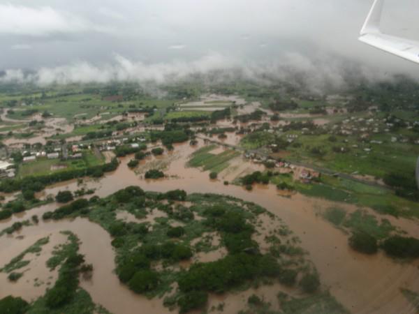
 An aerial shot of a flooded villager near the Ba coast. Picture: ISLAND DEVELOPMENTS. Source: fijitimes.com
26 January, 2012. 'Worse than 2009'
BA remained closed to all people and vehicular traffic yesterday in what has been termed "one of the worst floods ever".
With further rain forecast for the Western Division until the weekend, there are fears that floodwaters could rise to record heights in the next few days.
Ba special administrator Arun Prasad said he had never seen anything like it.
"This is worse than the flood in 2009 because of the duration and disruption to services and business. Elevated parts of Ba Town are under five to right feet of water while lower areas are under as much as 15 feet of water," he said. Source: fijitimes.com
Salt water is a clear indication that it is a sinking. The land is sinking, and the drainage affected.
26 January, 2012. Farmers lose out
FARMERS are losing livestock and seawater is inundating flat land as flooding continues to ravage the Western and Northern divisions.
This was confirmed by Ministry of Agriculture permanent secretary Colonel Mason Smith.
"The initial reports coming in are that farmers are losing their livestock because they are not able to move their livestock to higher ground in time," said Col. Smith. He said Monday night's high tide coupled with rain from the mountains had also caused a lot of farmers to lose their crops.
"If the water does not drain quickly, we stand to lose quite a bit, especially in the sugarcane areas, the dalo growing areas of the Ra province and likewise in the north," he said. Col. Smith said with livestock dying there was a risk of diseases like leptospirosis, however, these were issues the department would deal with on a case-by-case basis. He also advised farmers to harvest and preserve whatever crops they could and to relook at how they could handle flooding in the future.
With flooding continuously damaging Nadi plantations, Col. Smith said the department understood the need to relook at the drainage systems in the west.
"We will also look at our river dredging, we are currently working at the Ba River, the Rewa River and the Nadi River."
He said the department would also review its systems for preventing floods.
"Given the fact that flooding occurs all over the Western Division we will have to look at it holistically, whether we are cutting down too many trees up in the ridge, whether we are undertaking sustainable farming practices and whether the community understands not to plant along the river," said Col. Smith.
He said teams were trying to get indications of the initial damage to crops and livestock in the west. Source: fijitimes.com
11 January, 2012. Flooding sparks concern
VILLAGERS of Dakuinuku in Tailevu are pleading for assistance as they fight a losing battle with the sea which floods their village at high tide every day. Epeli Duvaga, the turaga ni mataqali Saniveikau said the villagers suspect the flooding is being caused by excavations of gravel at a riverbed upstream.
"So when the tides come in, the water flows into the village causing flooding." Mr Duvaga said the flooding had forced some villagers to relocate. Source: fijitimes.com
Views: 2545
Comment
SEARCH PS Ning or Zetatalk
Nancy Lieder, Emissary of the Zetas.
https://poleshift.ning.com/xn/detail/3863141:Comment:1168188
Awakening to the Alien Presence ZetaTalk
The truth will likely never to be known to the public but be washed away in the Nibiru panic soon to engulf the world.
The Worst of the Cover-Up
https://poleshift.ning.com/profiles/blogs/the-worst-of-the-cover-up
Main Establishment Lies
https://poleshift.ning.com/profiles/blogs/main-establishment-lies
Donate
© 2025 Created by 0nin2migqvl32.
Powered by
![]()
You need to be a member of Earth Changes and the Pole Shift to add comments!
Join Earth Changes and the Pole Shift