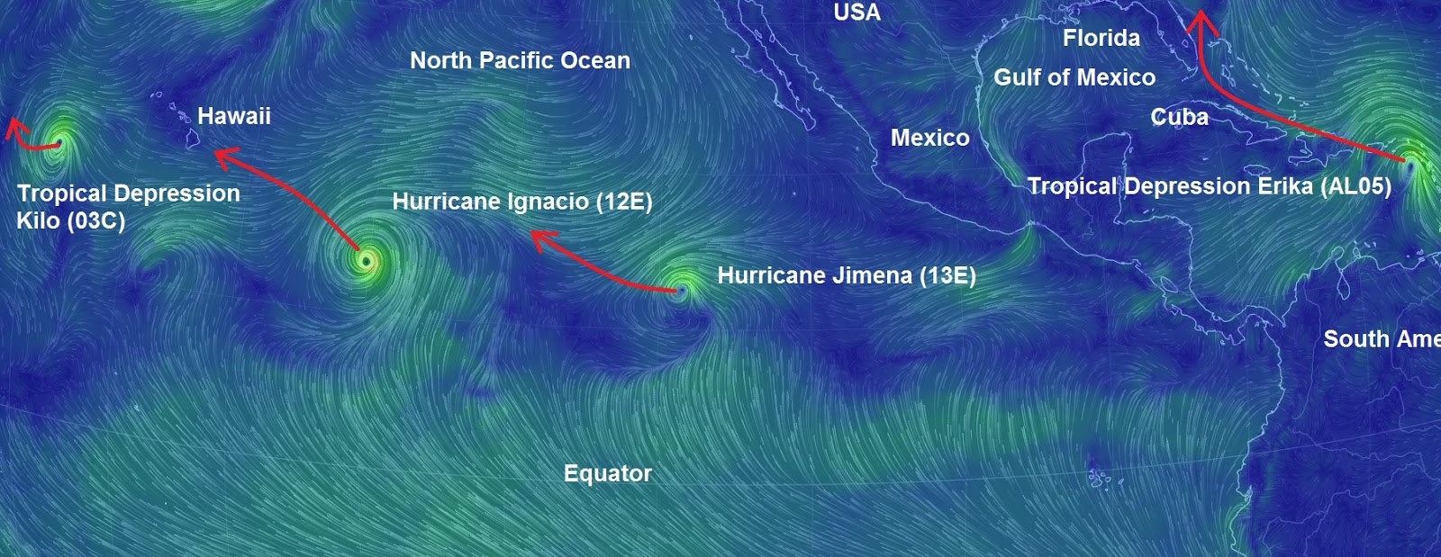
"We warned at the start of ZetaTalk, in 1995, thatunpredictable weather extremes, switching about from drought to deluge,would occur and increase on a lineal basis up until the pole shift. Where this occurred steadily, it has only recently become undeniable. ZetaTalk, and only ZetaTalk, warned of these weather changes, at that early date. Our early warnings spoke to the issue of global heating from the core outward, hardly Global Warming, a surface or atmospheric issue, but caused by consternation in the core. Affected by the approach of Planet X, which was by then starting to zoom rapidly toward the inner solar system for its periodic passage, the core was churning, melting the permafrost and glaciers and riling up volcanoes. When the passage did not occur as expected in 2003 because Planet X had stalled in the inner solar system, we explained the increasing weather irregularities in the context of the global wobble that had ensued - weather wobbles where the Earth is suddenly forced under air masses, churning them. This evolved by 2005 into a looping jet stream, loops breaking away and turning like a tornado to affect the air masses underneath. Meanwhile, on Planet Earth, droughts had become more intractable and deluges positively frightening, temperature swings bringing snow in summer in the tropics and searing heat in Artic regions, with the violence of storms increasing in number and ferocity."
The wobble seems to have changed, as the temperature in Europe suddenly plunged after being like an early Spring, Alaska has its coldest temps ever while the US and much of Canada is having an extremely mild winter. India went from fatal cold spell to balmy again. Has the Earth changed position vs a vs Planet X to cause this?[and from another]Bitter cold records broken in Alaska - all time coldest record nearly broken, but Murphy's Law intervenes[Jan 30]http://wattsupwiththat.com/2012/01/30/bitter-cold-records-broken-in-alaskaJim River, AK closed in on the all time record coldest temperature of -80°F set in 1971, which is not only the Alaska all-time record, but the record for the entire United States. Unfortunately, it seems the battery died in the weather station just at the critical moment. While the continental USA has a mild winter and has set a number of high temperature records in the last week and pundits ponder whether they will be blaming the dreaded "global warming" for those temperatures, Alaska and Canada have been suffering through some of the coldest temperatures on record during the last week.
There has been no change in the wobble pattern, the wobble has merely become more severe. Nancy noted a Figure 8 format when the Earth wobble first became noticeable, in early 2005, after Planet X moved into the inner solar system at the end of 2003. The Figure 8 shifted along to the east a bit on the globe between 2005 and 2009, (the last time Nancy took its measure) as Planet X came closer to the Earth, encountering the magnetic N Pole with a violent push earlier in the day. But the pattern of the Figure 8 remained essentially the same. So what changed recently that the weather patterns became noticeably different in late January, 2012?
The N Pole is pushed away when it comes over the horizon, when the noon Sun is centered over the Pacific. This regularly puts Alaska under colder air, with less sunlight, and thus the historically low temps there this January, 2012 as the wobble has gotten stronger. But by the time the Sun is positioned over India, the N Pole has swung during the Figure 8 so the globe tilts, and this tilt is visible in the weather maps from Asia. The tilt has forced the globe under the hot air closer to the Equator, warming the land along a discernable tilt demarcation line.
The next loop of the Figure 8 swings the globe so that the N Pole moves in the other direction, putting the globe again at a tilt but this time in the other direction. This tilt is discernable in weather maps of Europe, again along a diagonal line. Depending upon air pressure and temperature differences, the weather on either side of this diagonal line may be suddenly warm or suddenly cold. The tilt and diagonal line lingers to affect much of the US and Canada, but the Figure 8 changes at this point to be an up and down motion, pulling the geographic N Pole south so the US is experiencing a warmer than expected winter under a stronger Sun. Then the cycle repeats, with the magnetic N Pole of Earth pushed violently away again as the Sun is positioned over the Pacific.
Would the Zetas be able to let us know what is causing the early break-up of the Arctic Ice, the ice seems to have taken on a swirling pattern at the same time, would this be wobble related?[and from another]http://www.vancouversun.com/news/national/Canada+Arctic+cracks+spec... The ice in Canada’s western Arctic ripped open in a massive “fracturing event” this spring that spread like a wave across 1,000 kilometres of the Beaufort Sea. Huge leads of water – some more than 500 kilometres long and as much as 70 kilometres across – opened up from Alaska to Canada’s Arctic islands as the massive ice sheet cracked as it was pushed around by strong winds and currents. It took just seven days for the fractures to progress across the entire area from west to east.[and from another]http://earthobservatory.nasa.gov/IOTD/view.php?id=80752&src=iot... A high-pressure weather system was parked over the region, producing warmer temperatures and winds that flowed in a southwesterly direction. That fueled the Beaufort Gyre, a wind-driven ocean current that flows clockwise. The gyre was the key force pulling pieces of ice west past Point Barrow, the northern nub of Alaska that protrudes into the Beaufort Sea.
The Figure 8 formed by the N Pole during the daily Earth wobble has shifted somewhat to the East, due to Planet X positioned more to the right of the Earth during its approach. This was anticipated, and well described in ZetaTalk, the Earth crowding to the left in the cup to escape the approach of Planet X, so the angle between these two planets would change slightly. This shift of the Figure 8 to the East is due to the push against the Earth’s magnetic N Pole occurring sooner each day than prior. Thus instead of occurring when the Sun is high over the Pacific, over New Zealand, it is now occurring when the Sun is high over Alaska. All the wobble points have shifted eastward accordingly.
This has brought a lingering Winter to the western US, and a changed sloshing pattern to the Arctic waters. Instead of Pacific waters being pushed through the Bering Straits into the Arctic when the polar push occurs, the wobble is swinging the Arctic to the right, and then later to the left, creating a circular motion in the waters trapped in the Arctic. Since the Earth rotates counterclockwise, the motion also takes this path. This is yet another piece of evidence that the establishment is hard pressed to explain. They are attempting to ascribe this to high pressure and wind, all of which are not new to the Arctic, but this circular early breakup of ice in the Arctic is new.
Barely two tornadoes a year are recorded in Turkey every year, the last created damage in the heart of Istanbul in August 2014. Yesterday, a very impressive phenomenon occurred in the province of Isparta, west Turkey, in a very stormy context.
China Evacuates Thousands Ahead of Typhoon Chan-hom
People wait for a bus leaving a shopping district in Hong Kong as Typhoon Linfa approaches, July 9, 2015.
Chinese authorities have evacuated tens of thousands of people, canceled scores of trains and flights and shuttered seaside resorts as a super-typhoon with wind gusts up to 200 kph (125 mph) heads toward the southeastern coast.
China's national weather service said super Typhoon Chan-hom is expected to make landfall by early Saturday at the eastern province of Zhejiang, and has issued its highest-level alert.
Zhejiang's Civil Affairs Bureau said nearly 60,000 people were evacuated from coastal areas. The country's railway service said more than 100 trains between the region's cities are canceled through Sunday.
Services canceled
In the seaside city of Zhoushan, all flights in and out of its airport have been canceled.
The city has halted bus services and speedboat ferry services. Several tourist spots also were closed. In the nearby port city of Ningbo, 34 flights were canceled, the airport said.
Another 37 flights were canceled at the airport for another coastal city, Wenzhou.
This NOAA photo shows two typhoons in the Philippine Sea and a tropical storm near the China coast near Hong Kong and Macau which have the region on alert, taken July 10, 2015.
Several area cities also have announced suspension of inter-city bus services.
Chan-hom caused 20 injuries as it moved over islands in southern Japan, Kyodo news agency reported, citing the local government in Okinawa prefecture.
Weather warnings
The Japan Meteorological Agency warned of strong winds and high waves through the night.
The storm also dumped rain on northern Philippines and was expected to pass by Taiwan, where several flights were suspended.
The stock market and public offices were closed Friday in Taipei, the island's capital, authorities announced.
Southern China already was struck by another typhoon earlier this week. Typhoon Linfa displaced 56,000 people in southern Guangdong province.
In Twente was measured in the night from Thursday to Friday light frost.That is unique for July.The official measurement in Twente, at the airport, 1.3 degrees below zero was measured.
That means no outdoor sprinklers, no filling up swimming pools, and no washing cars, driveways, sidewalks, or buildings. Strict rules for watering gardens are also in effect.
A breakdown of the different levels of water restrictions, from levels 1 to 4.
The City of Vancouver is currently under a level 2 water restriction, which means lawn-watering is allowed, but only on certain days of the week.
Across the province, 197 fires are burning, prompting nine evacuation orders and eight states of local emergency. The B.C. government has spent nearly $97 million fighting the flames, far exceeding its $63-million budget already.
A blanket of green algae has covered at least 35,000 square kilometres of water along the coast of eastern China’s Shandong province.
While extreme enteromorpha algae blooms have been occurring here since 2007, it’s been quite the spectacle recently in the seaside towns of Qingdao and Rizhao.
The New York Times reported during the 2013 algae bloom that scientists still had no concrete explanation for the extraordinary coverage of algae.
Although green algae is not known to be harmful to humans, it can cause widespread destruction to marine life.
Chinese authorities spent millions of dollars on algae cleanup in 2008, the South China Morning Post reports. Officials deployed the People’s Liberation Army to rid the beaches of the green mess as the waters were being used for sailing events during the Beijing Olympic Games.
Neighborhoods Evacuated Near Indianapolis; Meteorologists Warn More Flooding Likely
Residents from the Southern Plains to the Ohio Valley could see more dangerous flash flooding again Wednesday, forecasters say.
On Tuesday, heavy storms dumped hours-worth of rain in pockets across these regions. First responders pulled people from vehicles and homes in three separate states: Texas, Kentucky and Missouri.
Downpours slammed Indianapolis on Tuesday evening, prompting evacuations west of the city.
The streets of Manhattan, Indiana, under water Tuesday.
This is the same system that brought heavy flooding to Kansas City, Wichita, Las Vegas and Reno, Nevada, on Monday night.
You can get the latest forecast at the weather.com severe tracker.
Here's the very latest from the impacted states:
Indiana
Nearly 4.5 inches of rain was recorded at the Indianapolis International Airport Tuesday afternoon, according to weather.com meteorologist Linda Lam, breaking a 100-year-old record. The city of Plainfield, just west of the airport, received 5.4 inches in less than four hours.
Wayne Township was hard hit. WISH TV reported about 20 homes were flooded and up to 60 people were evacuated.
The rain started before sunrise, around 5 a.m., and drenched parts of western Kentucky with 5 inches in a short amount of time.
McCracken County Emergency Management Director Jerome Mansfield told the Associated Press the "torrential downpour of rain" led to an apartment complex and a motel being evacuated and crews rescuing multiple people from vehicles that got stuck in high water, mostly in low-lying areas. He said he wasn't sure how many people were evacuated and rescued.
No injuries were reported and Mansfield said officials were trying to assess the damage now that the rain has stopped.
The American Red Cross was opening a shelter in Paducah overnight for anyone who couldn't return to their homes because of flooding.
West Kentucky Star reports that Paducah police participated in at least 18 water rescues from stalled vehicles.
Missouri
Enlarge
Cars swept into a pile Tuesday by flooding in Branson, Missouri. (Sierra Dobson) (Sierra Dobson)
A flash flood emergency was issued Tuesday morning for parts of Stone and Taney counties in Missouri, including the city of Branson. Significant flash flooding was reported in Kimberling City, Reeds Spring and along Roark Creek. Multiple water rescues have been reported in Branson, according to Branson Fire-Rescue.
The Barry County Sheriff's department told the Joplin Globe crews have had to evacuate some Cassville residents and rescue others because of flooding. The sheriff's department advises people to stay away from Cassville, saying on its Facebook page that "Cassville is CLOSED! Do NOT come to Cassville!"
The Missouri Department of Transportation also closed several highways and roads around Cassville.
The Abilene Regional Airport recorded 7.15 inches of rain on Tuesday through 1:40 p.m. CDT, making it their all-time wettest calendar day on record. The previous record was 6.54 inches on May 11, 1928.
By afternoon, storms over San Angelo prompted at least 20 water rescues, according to the sheriff's office.
As a very strong earthquake: the tornado that struck yesterday afternoon the Riviera del Brenta Venetian has literally leveled Villa Fini, known historically as Villa Santorini-Toderini-Fini, dating back at least four centuries ago.
The tornado of Mira and Dolo: an F4 with winds of 300km / h, among the most violent in the history of Italy
The tornado of Mira and Dolo and the Fujita scale: it was an event of category F4
July 9, 2015
The tornado that yesterday afternoon, Wednesday, July 8, hit the Brenta River between Mira, Dolo, Cazzago Sambruson and was one of the most violent in the history of Italy. Based on the damage caused to the ground, we can classify without any shadow of doubt this tornado as an F4 on the Fujita Scale. F2 not as it seemed at first, not F3 as we assumed in late last night, but even an F4, a violent phenomenon, in a scale ranging from F0 to F5 then the fifth level on a scale of six.
Based on the damage yesterday in Venice, the tornado was certainly of category F4 in areas where this has resulted in the total destruction of brick houses and lifted the car at great speed and distance
The winds in this category range between 270 and 320km / h, it is therefore likely that yesterday you have reached 300km / h. The images of Villa Fini razed in Dolo are impressive , but the brick houses destroyed by the tornado are lots , over 100.
Very impressive video of the severe downburst near Halle/Saale in NNE Germany yesterday. Wait until the end to see how the powerful winds can cause severe destruction. JULY 7 2015
Unprecedented Wildfires in Canada by the Numbers (Jul 7) Drought conditions have sparked wildfires across western Canada, contributing to smoky haze seen as far east as Quebec and the United States.
Here's a breakdown of the current situation:
British Columbia
Wildfires have burned through over half a million acres in B.C. this year.
Since April 1, 900 wildfires have been sparked in B.C. alone.
There are 184 active wildfires currently burning in B.C.
More than 800 people have been evacuated or put on evacuation alert across the province.
June 18, or 22 days ago, was the last time B.C.'s South Coast has seen measurable rainfall.
On Tuesday, the air quality rating in Whistler was on par with some of the world's most polluted cities.
Smoke from the B.C. fires has spread across all three Prairie provinces and into Ontario and Quebec.
The smoke is large enough to be spotted from space by NASA satellites.
Saskatchewan
There have been 582 wildfires in Saskatchewan so far this season, compared to 210 in 2014.
13,000 people have been evacuated in northern Saskatchewan due to wildfire threat.
1,400 military personnel may be sent to help with the fires in Saskatchewan.
As of July 7, there were 113 active wildfires in Saskatchewan.
Smoke from the wildfires has affected areas in the United States, including Wisconsin and Colorado.
You need to be a member of Earth Changes and the Pole Shift to add comments!
Join Earth Changes and the Pole Shift