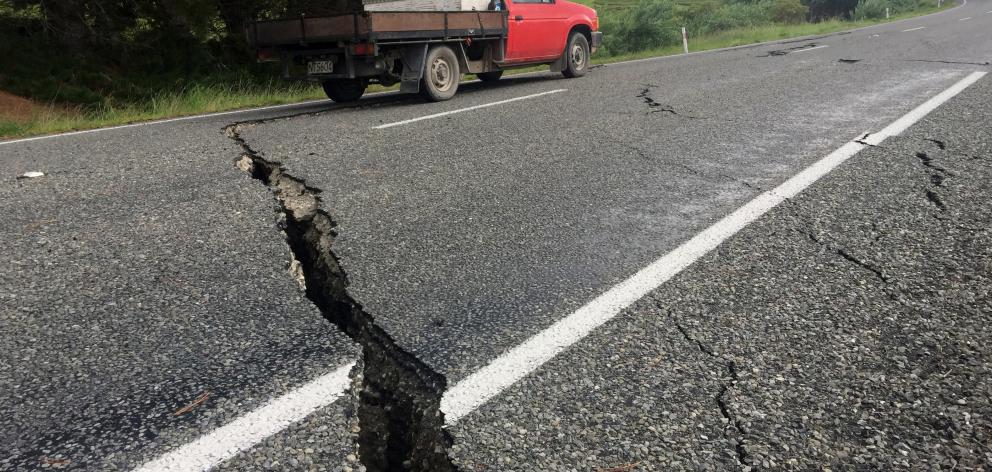
A truck drives over the fractured road caused by the November 14 Kaikoura earthquake south of the town of Ward.
Earthquakes Today, November 7, 2025
Altering Earthquakes:
As of late, I have observed that USGS and EMSC are a bit lax on their reports of earthquakes. Sometimes not seeing anything reported for hours from the last update, or seeing periods of 90-200 minutes with no earthquakes in between. My question is, are they leaving swarms of earthquakes out of their reports, or there are actually periods of no earthquakes?
SOZT: Greater than 90% of the earthquake activity is being altered by the USGS at present, which is under orders to prevent any clue being given to the public about the Earth changes caused by the presence of Planet X. Over a decade ago, the approach was to de-sensitize the live seismographs periodically, so the displays do not turn black worldwide, and to ignore the twice-a-day patterns showing up on these seismographs. Then any quakes that could be dropped were dropped. This was obvious to some who were watching the database manipulation. Quakes in the list would suddenly disappear. This was particularly the case where a quake happened in a remote location, or out in the ocean. Dumbing down the magnitude quickly followed, but in order to ensure the public did not notice, the USGS took control of all websites reporting quake statistics. At times, this control breaks, and discrepancies are reported to the public. Some countries rebel. Quake swarms are another source of control, as they pepper the databases with many quakes and skew the statistics, and thus are pulled from the database. Else the question is raised, why so many? EOZT
Will the USGS internet system be a reliable warning system for the European tsunami by registering on the net the New Madrid earthquake on the exact time it occurs?
SOZT: It will not be a lack of information from the USGS that will be the point of confusion during the earthquakes leading up to the New Madrid adjustment, it will be knowing which quake is the big one vs the many minor quakes preceding it. The USGS downgrades almost all earthquakes, to prevent meaningful statistics from being generated from their databases. They also exclude quakes whenever they can, but this is unlikely to happen in the New Madrid area as it is in the center of a populated land mass. Thus you will have magnitude 6 quakes that will be called a 5.2, magnitude 7 quakes called a 6.1, and when a magnitude 8 or greater quake occurs, it will be called a 6.9.
We would advise that rather than watching the USGS quake statistics, that you watch the Earth changes. The adjustment that will incite the European tsunami will involve bridges on the Mississippi breaking, and being impassable. The land to the west of the Mississippi will drop so that the Mississippi will become 50 miles wide in the state of Mississippi. Watch for this. The New Madrid adjustment will be several large quakes of magnitude 8-9, though will be listed as a lesser magnitude. As the N American continent continues to unzip up to and along the Seaway, the quakes will be less than a magnitude 8 but very destructive to Cleveland and Toledo and Buffalo and the inland locks along the Seaway. Thus it is not what the USGS says that should be watched, but the condition of the bridges on the Mississippi, the impact on the cities along the Seaway, and whether the inland locks are reported as inoperable. EOZT
Views: 581182
Comment
6.9
94km WSW of Kirakira, Solomon Islands
2016-12-09 19:10:07 (UTC)
20.6 km http://earthquake.usgs.gov/earthquakes/eventpage/us20007zlq#executive
6.1
78km SW of Kirakira, Solomon Islands
2016-12-09 21:38:23 (UTC)
14.0 km http://earthquake.usgs.gov/earthquakes/eventpage/us20007zn7#executive
5.0
93km WSW of Kirakira, Solomon Islands
2016-12-09 21:33:17 (UTC)
10.0 km
4.7
77km SW of Kirakira, Solomon Islands
2016-12-09 20:44:45 (UTC)
37.9 km
5.1
90km SW of Kirakira, Solomon Islands
2016-12-09 20:35:15 (UTC)
15.8 km
5.5
86km SW of Kirakira, Solomon Islands
2016-12-09 19:43:26 (UTC)
33.7 km
5.3
95km WSW of Kirakira, Solomon Islands
2016-12-09 19:38:35 (UTC)
45.5 km
4.9
106km WSW of Kirakira, Solomon Islands
2016-12-09 19:34:57 (UTC)
41.1 km USGS
5.2
58km W of Kirakira, Solomon Islands
2016-12-09 18:13:11 (UTC)
58.9 km
4.9
97km WSW of Kirakira, Solomon Islands
2016-12-09 18:12:00 (UTC)
35.0 km
5.4
102km WSW of Kirakira, Solomon Islands
2016-12-09 17:55:51 (UTC)
38.6 km
5.2
84km W of Kirakira, Solomon Islands
2016-12-09 17:24:42 (UTC)
43.0 km
------------------------
Euro-Med Seismological Centre (EMSC)
7 hrs ·
#Croatia | Pictures sent from one of our Twitter followers: "Asphalt cracks on Split streets!"
BREAKING] M4.7 #earthquake (#potres / #zemljotres) felt in #Croatia & #Bosniaandherzegovina.
8.0
68km WSW of Kirakira, Solomon Islands
2016-12-08 17:38:47 (UTC)
40.3 km http://earthquake.usgs.gov/earthquakes/eventpage/pt16343053#executive
Felt earthquake M6.8 in OFF COAST OF NORTHERN CALIFORNIA also felt in San Francisco Bay Area, Calif. 26 minutes ago More info EMSC
6.5
157km W of Ferndale, California
2016-12-08 14:49:46 (UTC)
10.0 km
http://earthquake.usgs.gov/earthquakes/eventpage/us20007z6r#executive USGS
http://www.emsc-csem.org/Earthquake/Testimonies/comments.php?id=551181 EMSC
Euro-Med Seismological Centre (EMSC)
4 hrs ·
[BREAKING] #Indonesia: "The tremors felt even stronger than the 2004 earthquake."
Deadly magnitude 6.5 earthquake hits Aceh in Indonesia
http://www.bbc.com/news/world-asia-38232611?ns_mchannel=social&...
In 2004, a huge undersea quake off the coast of Aceh caused a tsunami that killed more than 160,000 people in Indonesia alone.
There was no tsunami after Wednesday's tremor, which the US Geological Survey said struck just offshore at 05:03 local time (22:03 GMT Tuesday) at a depth of 8km
The quake shook Banda Aceh and prompted many people across the region to flee their homes. Many are said to be reluctant to go back indoors, amid a number of aftershocks.
Musman Aziz, who lives in Meureudu, another affected town, told AP news agency: "It was very bad, the tremors felt even stronger than (the) 2004 earthquake... I was so scared the tsunami was coming."
Felt earthquake M6.4 in NORTHERN SUMATRA, INDONESIA 14 minutes ago
M 6.4 - NORTHERN SUMATRA, INDONESIA - 2016-12-06 22:03:32 UTC
http://www.emsc-csem.org/Earthquake/earthquake.php?id=550779
Felt earthquake M5.8 in TRINIDAD REGION, TRINIDAD-TOBAGO EMSC
5.8
25km SW of Scarborough, Trinidad and Tobago
2016-12-06 21:42:20 (UTC)
35.8 km http://earthquake.usgs.gov/earthquakes/eventpage/us10007ggp#executive
Recap: Severe earthquake rocks central New Zealand
December 4 2016
http://i.stuff.co.nz/national/87180415/live-severe-earthquake-rocks...
Magnitude 4.6
Region COOK STRAIT, NEW ZEALAND
Date time 2016-12-06 20:40:46.5 UTC
Location 41.82 S ; 174.27 E
Depth 30 km http://m.emsc.eu/earthquake/earthquake.php?evid=550768
Magnitude 4.4
Region OFF COAST OF NORTHERN CALIFORNIA
Date time 2016-12-06 17:07:29.1 UTC
Location 41.44 N ; 126.25 W
Depth 11 km http://m.emsc.eu/earthquake/earthquake.php?evid=550740
Magnitude mb 5.4
Region VANUATU
Date time 2016-12-06 01:21:18.4 UTC
Location 14.91 S ; 167.32 E
Depth 105 km
Magnitude 5.3
Region JUJUY, ARGENTINA
Date time 2016-12-05 18:06:04.8 UTC
Location 23.26 S ; 66.58 W
Depth 199 km http://m.emsc.eu/earthquake/earthquake.php?evid=550518
Magnitude 4.6
Region PUERTO RICO REGION
Date time 2016-12-05 14:29:52.3 UTC
Location 17.78 N ; 65.88 W
Depth 8 km http://m.emsc.eu/earthquake/earthquake.php?evid=550487
Magnitude M 6.1
Region BANDA SEA
Date time 2016-12-05 01:13:04.4 UTC
Location 7.35 S ; 123.43 E
Depth 530 km http://www.emsc-csem.org/Earthquake/earthquake.php?id=550338
Magnitude mb 4.5
Region DOMINICAN REPUBLIC
Date time 2016-12-05 00:44:03.8 UTC
Location 18.59 N ; 69.04 W
Depth 137 km
Magnitude 4.6
Region GREECE
Date time 2016-12-03 21:04:34.8 UTC
Location 38.11 N ; 21.95 E
Depth 10 km
Magnitude mb 6.0
Region NEAR ISLANDS, ALEUTIAN ISLANDS
Date time 2016-12-03 09:23:36.7 UTC
Location 52.46 N ; 174.22 E
Depth 40 km
http://www.emsc-csem.org/Earthquake/earthquake.php?id=549966
Magnitude 6.0
Region SOUTHERN PERU
Date time 2016-12-01 22:40:32.5 UTC
Location 15.44 S ; 70.81 W
Depth 60 km
http://m.emsc.eu/earthquake/earthquake.php?evid=549648
https://www.odt.co.nz/news/national/unusual-seismic-activity-prompt...
Civil Defence Minister Gerry Brownlee says a public statement about unusual seismic activity in the lower North Island is not a cause for alarm.
In a statement released this afternoon, Mr Brownlee said GNS Science had observed "unusual activity involving patches of slow-slip activity'' between tectonic plates under the region.
"The heightened activity increases the uncertainty about the likelihood and size of future earthquakes,'' he said.
Mr Brownlee said the observations by GNS were a timely reminder for New Zealanders to be prepared for earthquakes.
Speaking to reporters at Parliament later, the minister clarified that his statement did not amount to a warning about future quakes.
"I just want to make sure that what we are doing is putting that information out there that it is advisable to be prepared.
"We're not creating alarm, we're just creating awareness.''
Since the November 14 earthquake near Kaikoura, a series of simultaneous "slow-slip'' quakes have been observed in Gisborne, the Hawkes Bay, and Kapiti.
Slow-slip quakes move just millimetres at a time and are detected by GPS because they cannot be picked up by seismographs.
Mr Brownlee said GNS Science was still trying to understand what the slow-slip quakes meant for the region. The phenomenon had only been analysed in New Zealand for a relatively short period of 15 years.
"So what we're saying is `Does this mean the risk is a little heightened?' And [GNS] is saying `It would be prudent to restate the public [civil defence] messages'.''
It was also important for the Government to issue robust scientific information to stop "amateurs interpreting scientific information in a negative way'', Mr Brownlee said.
GNS has advised that it is extremely unlikely there will be an aftershock of similar scale or larger than the Magnitude 7.8 quake on November 14.
In a blog post published today, GNS scientist Laura Wallace said it was not known what impact the slow-slip events could have on future earthquakes. Slow-slip quakes had been recorded in the lower North Island for 15 years, but not in multiple locations all at once, she said.
"But we've never tracked slow-slip events after a large magnitude 7.8 earthquake, so this could [be] the normal pattern after a large quake.''
The exact risk of a future quake could not be calculated because the science slow-slop movement was still "in its infancy'', Ms Wallace said.
Tsunami Warning for Central America:
https://translate.google.com/translate?hl=es&sl=auto&tl=en&...
Gulf of Fonseca 7.2 Quake
https://translate.google.com/translate?hl=es&sl=auto&tl=en&...
meanwhile Iris is Offline:
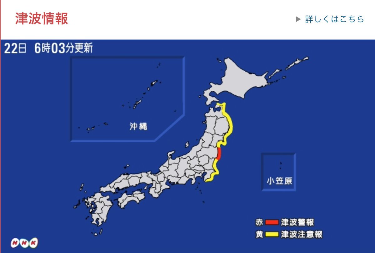
Tsunami waves and meteorite caught on camera after Japan quake
http://www.dailymail.co.uk/news/article-3958936/Videos-reveal-panic...
https://www.rt.com/news/367700-japan-fukushima-earthquake-tsunami/
A powerful 7.3 magnitude earthquake has struck Fukushima Prefecture in Japan, USGS reported. A three meter tsunami wave alert was issued for Fukushima, Nippon reported.

http://www.emsc-csem.org/Earthquake/alert/?id=DBPO0;INFO&date=2...
Nancy Lieder, Emissary of the Zetas.
https://poleshift.ning.com/xn/detail/3863141:Comment:1168188
Awakening to the Alien Presence ZetaTalk
The truth will likely never to be known to the public but be washed away in the Nibiru panic soon to engulf the world.
The Worst of the Cover-Up
https://poleshift.ning.com/profiles/blogs/the-worst-of-the-cover-up
Main Establishment Lies
https://poleshift.ning.com/profiles/blogs/main-establishment-lies
© 2025 Created by 0nin2migqvl32.
Powered by
![]()
You need to be a member of Earth Changes and the Pole Shift to add comments!
Join Earth Changes and the Pole Shift