EARTHQUAKES Worldwide! (Frequently Updated)

Domino Quakes 4/24/26

Significant Earthquakes, April 23, 2026


Altering Earthquakes:

ZetaTalk Aug 7, 2010

As of late, I have observed that USGS and EMSC are a bit lax on their reports of earthquakes. Sometimes not seeing anything reported for hours from the last update, or seeing periods of 90-200 minutes with no earthquakes in between. My question is, are they leaving swarms of earthquakes out of their reports, or there are actually periods of no earthquakes?

SOZT:   Greater than 90% of the earthquake activity is being altered by the USGS at present, which is under orders to prevent any clue being given to the public about the Earth changes caused by the presence of Planet X. Over a decade ago, the approach was to de-sensitize the live seismographs periodically, so the displays do not turn black worldwide, and to ignore the twice-a-day patterns showing up on these seismographs. Then any quakes that could be dropped were dropped. This was obvious to some who were watching the database manipulation. Quakes in the list would suddenly disappear. This was particularly the case where a quake happened in a remote location, or out in the ocean. Dumbing down the magnitude quickly followed, but in order to ensure the public did not notice, the USGS took control of all websites reporting quake statistics. At times, this control breaks, and discrepancies are reported to the public. Some countries rebel. Quake swarms are another source of control, as they pepper the databases with many quakes and skew the statistics, and thus are pulled from the database. Else the question is raised, why so many?   EOZT


ZetaTalk Jun 18, 2011

Will the USGS internet system be a reliable warning system for the European tsunami by registering on the net the New Madrid earthquake on the exact time it occurs?

SOZT:   It will not be a lack of information from the USGS that will be the point of confusion during the earthquakes leading up to the New Madrid adjustment, it will be knowing which quake is the big one vs the many minor quakes preceding it. The USGS downgrades almost all earthquakes, to prevent meaningful statistics from being generated from their databases. They also exclude quakes whenever they can, but this is unlikely to happen in the New Madrid area as it is in the center of a populated land mass. Thus you will have magnitude 6 quakes that will be called a 5.2, magnitude 7 quakes called a 6.1, and when a magnitude 8 or greater quake occurs, it will be called a 6.9.

We would advise that rather than watching the USGS quake statistics, that you watch the Earth changes. The adjustment that will incite the European tsunami will involve bridges on the Mississippi breaking, and being impassable. The land to the west of the Mississippi will drop so that the Mississippi will become 50 miles wide in the state of Mississippi. Watch for this. The New Madrid adjustment will be several large quakes of magnitude 8-9, though will be listed as a lesser magnitude. As the N American continent continues to unzip up to and along the Seaway, the quakes will be less than a magnitude 8 but very destructive to Cleveland and Toledo and Buffalo and the inland locks along the Seaway. Thus it is not what the USGS says that should be watched, but the condition of the bridges on the Mississippi, the impact on the cities along the Seaway, and whether the inland locks are reported as inoperable.   EOZT 

Views: 596685

Comment

You need to be a member of Earth Changes and the Pole Shift to add comments!

Join Earth Changes and the Pole Shift

Comment by Juan F Martinez on Sunday

2.9M earthquake by Detroit, Michigan and Amherstburg, Canada.

Comment by Juan F Martinez on Sunday

Days of Mystery Shaking in SAN BERNARDINO CO., California. Residents across the Victor Valley reported feeling shaking throughout Friday, Apr 24, as well as over the past several days, with many describing rattling windows, moving doors & vibrations strong enough to shake their homes.

The source of the shaking remains unconfirmed.

According to the USGS, data recorded on a seismic monitoring website shows a minor event labeled “M 1.1 Quarry Blast – 9 km NNW of Big Bear Lake, CA,” with a timestamp of Apr 24, 2026, at 16:39:56 & coordinates of 34.322°N, 116.933°W at a depth of -1.7 km.

The negative depth reading is consistent with surface-level activity such as quarry blasting rather than a natural earthquake.

Despite the recorded event, officials have not confirmed whether the shaking felt across the Victor Valley is directly connected to quarry operations, military activity, or experimental flight testing.

https://t.me/ZetaTalk_Followers/87582

Comment by Juan F Martinez on Saturday

Earthquakes, Petrolia, California 4/25/26

Comment by Juan F Martinez on Saturday

Significant Earthquakes Alaska 4/25/26

3.7 ~ Ninilchik, Alaska
Apr 25, 2026, 6:36 AM

3.3 ~ Akutan, Alaska
Apr 25, 2026, 5:19 AM

3.5 ~ Akutan, Alaska
Apr 25, 2026, 4:03 AM

3.6 ~ Akutan, Alaska
Apr 25, 2026, 2:43 AM

3.2 ~ Akutan, Alaska
Apr 25, 2026, 2:42 AM

3.5 ~ Akutan, Alaska
Apr 25, 2026, 2:26 AM

3.4 ~ Akutan, Alaska
Apr 25, 2026, 2:11 AM

5.4 ~ Akutan, Alaska
Apr 25, 2026, 2:05 AM

3.1 ~ Rat Islands, Aleutian Islands, Alaska
Apr 24, 2026, 11:24 PM

4.5 ~ Attu Station, Alaska
Apr 24, 2026, 11:18 PM

4.2 ~ Attu Station, Alaska
Apr 24, 2026, 10:16 PM

3.1 ~ Willow, Alaska
Apr 24, 2026, 5:59 PM

Comment by Juan F Martinez on April 25, 2026 at 5:06am

Domino earthquakes are a sign of the Pacific Ocean compressing. It began with a magnitude 5.1 at the Fox Islands in the Aleutians, Alaska, then quakes followed in a chain along the Pacific coast to California and continued down to Chile.

The severe Earth wobble is causing significant plate movement all around the planet. The Zetas predict that continental drift will start before the pole shift, be followed by a massive shift during it, and continue for some time afterward.

3.5 ~ Atka, Alaska
Apr 24, 2026, 10:48 AM

3.1 ~ Trapper Creek, Alaska
Apr 24, 2026, 10:21 AM

3.1 ~ Akutan, Alaska
Apr 24, 2026, 8:21 AM

3.3 ~ Nikolski, Alaska
Apr 24, 2026, 6:12 AM

3.9 ~ Adak, Alaska
Apr 24, 2026, 4:02 AM

4.1 ~ Nikolski, Alaska
Apr 24, 2026, 3:34 AM

4.0 Petrolia, California

April 24, 2026 1:29 PM

5.0 Atacama, Chile

April 24, 2026 1:29 PM

Comment by Juan F Martinez on April 24, 2026 at 6:49pm

4.4 ~ Taiwan Region
Apr 24, 2026, 8:56 AM

5.1 ~ E Coast Kamchatka
Apr 24, 2026, 6:49 AM

5.4 ~ E Coast Kamchatka
Apr 24, 2026, 4:04 AM

5.3 ~ E Coast Kamchatka
Apr 24, 2026, 2:59 AM

4.5 ~ Kuril Islands
Apr 24, 2026, 2:46 AM

4.6 ~ Molucca Sea
Apr 24, 2026, 2:41 AM

4.3 ~ Kepulauan Babar, Indonesia
Apr 24, 2026, 2:30 AM

4.8 ~ New Ireland Region, P.N.G.
Apr 24, 2026, 1:26 AM

4.4 ~ S Coast Myanmar
Apr 24, 2026, 1:03 AM

5.0 ~ E Coast Honshu, Japan
Apr 23, 2026, 11:13 PM

5.3 ~ Molucca Sea
Apr 23, 2026, 10:45 PM

4.5 ~ Tonga
Apr 23, 2026, 9:15 PM

4.0 ~ Kep. Tanimbar Region, Indonesia
Apr 23, 2026, 9:10 PM

5.4 ~ S Kermadec Islands
Apr 23, 2026, 7:52 PM

4.5 ~ Vanuatu
Apr 23, 2026, 6:21 PM

4.9 ~ Rota Region, N Mariana Islands
Apr 23, 2026, 5:22 PM

5.0 ~ SE Ryukyu Islands
Apr 23, 2026, 4:52 PM

4.6 ~ Kepulauan Babar, Indonesia
Apr 23, 2026, 4:13 PM

4.2 ~ Izu Islands, Japan Region
Apr 23, 2026, 4:10 PM

4.8 ~ S Kermadec Islands
Apr 23, 2026, 11:46 AM

4.6 ~ E Coast Honshu, Japan
Apr 23, 2026, 10:56 AM

https://poleshift.ning.com/profiles/blogs/earthquakes-worldwide

Comment by Tracie Crespo on April 20, 2026 at 2:04pm

Strong earthquake hits off Japan’s coast, tsunami advisory issued


A television shows a news report on Japan Meteorological Agency's tsunami warning on Monday, saying the agency expects tsunami waves of up to three meters (9.8 feet) to reach coastal areas in northeastern Japan.


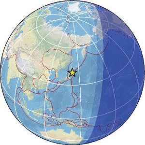
A three-meter (9.8-foot) tsunami warning was issued for Japan on Monday after a strong 7.4 magnitude earthquake struck off the northeastern coast, according to the Japan Meteorological Agency and the US Geological Survey. The threat was later revised down to a tsunami advisory, authorities said.

The Japan Meteorological Agency initially issued a three-meter tsunami warning for the Iwate prefecture and parts of Hokkaido and Aomori – later downgraded to an advisory. It also issued an advisory in other areas of northeastern Japan, estimating a tsunami of up to one meter (3.3 feet). The agency also warned that aftershocks of a similar magnitude could happen in the coming week.

So far, observations of tsunami waves are all well below the warning level that was issued. One 0.8-meter (2.6-foot) tsunami has struck Kuji Port in Iwate Prefecture, where Japan’s national broadcaster NHK has reported the water is still rising. Another 0.4-meter (1.3-foot) tsunami hit Miyako Port in Iwate Prefecture.

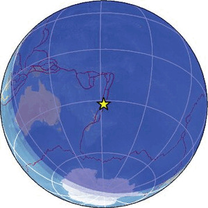
The US Tsunami Warning System reported that the magnitude of the earthquake off the east coast of Honshu, Japan, was 7.4. The tsunami threat was issued at 8:52 UTC (4:52 a.m. ET). Japan’s national agency later revised its figure up to 7.7 magnitude, although it’s unclear why there is a discrepancy in the numbers.

No injuries or damage to homes has been recorded as of yet, chief cabinet secretary Minoru Kihara said in an update Monday evening local time, but the situation is still being assessed. Kihara added that there are 200 power outages across the impacted areas and authorities are working to restore service.

CNN’s producer on the ground in Tokyo reported feeling the building they were in shake for about seven minutes when the earthquake struck.

Japanese Prime Minister Sanae Takaichi has urged residents in affected areas to evacuate immediately and said the government had set up an emergency task force.

“Residents in areas where tsunami warnings have been issued should immediately evacuate to higher ground or safer locations such as evacuation buildings,” Takaichi told reporters in a news briefing on Monday, shortly after the earthquake.

Authorities are doing their “utmost to assess the damage, implement emergency disaster response measures such as search and rescue operations, and provide timely and accurate information to the public,” Takaichi said. “At this time, we are still confirming the extent of human and material damage, but we will receive detailed reports shortly and proceed with disaster response efforts.”

The operator of the bullet train service that runs between Tokyo and Shin-Aomori station said the train had been suspended due to a power outage caused by the earthquake, NHK reported. Train services have also been suspended between Akita Station and Morioka Station in northern Japan. All local trains in Iwate prefecture have halted services, according to NHK.

Tokyo Electric Power Company said in a statement that no abnormalities have been detected at its Fukushima Daiichi and Fukushima Daini nuclear power plants, although it has evacuated workers. The Tohoku Electric Power Company said that its Onagawa nuclear plant and Higashidori nuclear plant further north have also not experienced abnormalities, with radioactive material levels still within normal range.

Japan is one of the most earthquake-prone countries in the world. It lies on the Ring of Fire, an area of intense seismic and volcanic activity on both sides of the Pacific Ocean. The worst quake in recent Japanese history was the 9.1-magnitude Tohoku earthquake in 2011, which triggered a major tsunami and nuclear disaster.

He added that Japan also accounts for roughly 20% of the world’s magnitude-6+ earthquakes.

“Even waves that do not look dramatic can still be dangerous,” Karmpadakis added in a statement. “A tsunami does not need to be towering to cause harm: the real danger is fast-moving water surging in and out, creating currents strong enough to knock people over, damage boats and push water up rivers and into harbours.”

This is a developing story and has been updated.

https://www.cnn.com/2026/04/20/world/earthquake-tsunami-warning-jap...

Comment by Tracie Crespo on April 20, 2026 at 1:57pm
Magnitude  7.4
Region NEAR EAST COAST OF HONSHU, JAPAN
Date time 2026-04-20 07:52:58.2 UTC
Location 40.027 ; 142.968
Depth 11 km
Distance 135 km ESE of Hachinohe, Japan / pop: 239,000 / local time: 16:52:58.2 2026-04-20
97 km NE of Miyako, Japan / pop: 51,700 / local time: 16:52:58.2 2026-04-20
Source parameters reviewed by a seismologist


Global view
Comment by Tracie Crespo on April 19, 2026 at 8:47pm
Magnitude  6.1
Region TONGA
Date time 2026-04-19 17:34:47.4 UTC
Location -15.126 ; -173.616
Depth 36 km
Distance 246 km SW of Apia, Samoa / pop: 40,400 / local time: 06:34:47.4 2026-04-20
207 km SSW of Asau, Samoa / pop: 6,600 / local time: 06:34:47.4 2026-04-20
Source parameters provided by:

National Earthquake Information Center, U.S. Geological Survey -- Golden, United States (NEIC)


Global view
-------------------------------------------------------------------------------------------------------------------------------------------
Magnitude  3.7
Region UTAH
Date time 2026-04-19 14:43:47.6 UTC
Location 38.725 ; -112.476
Depth 5 km
Distance 182 km SSW of Provo, United States / pop: 115,000 / local time: 08:43:47.6 2026-04-19
34 km WSW of Richfield, United States / pop: 7,500 / local time: 08:43:47.6 2026-04-19
Source parameters provided by:

National Earthquake Information Center, U.S. Geological Survey -- Golden, United States (NEIC)
 
Global view
---------------------------------------------------------------------------------------------------------------------------------------
Magnitude  4.7
Region NEVADA
Date time 2026-04-19 14:39:16.3 UTC
Location 39.292 ; -119.115
Depth 13 km
Distance 66 km ESE of Reno, United States / pop: 241,000 / local time: 07:39:16.3 2026-04-19
17 km SE of Silver Springs, United States / pop: 5,200 / local time: 07:39:16.3 2026-04-19
Source parameters provided by:

National Earthquake Information Center, U.S. Geological Survey -- Golden, United States (NEIC)
 
Global view
Comment by Tracie Crespo on April 18, 2026 at 2:49pm
Magnitude  5.9 (was listed as a 6.1 just a while ago)
Region SOUTH OF KERMADEC ISLANDS
Date time 2026-04-18 10:47:54.9 UTC
Location -32.088 ; -178.063
Depth 10 km
Distance 815 km NNE of Tauranga, New Zealand / pop: 110,000 / local time: 22:47:54.9 2026-04-18
697 km NNE of Hicks Bay, New Zealand / pop: 1,300 / local time: 22:47:54.9 2026-04-18
Source parameters provided by:

National Earthquake Information Center, U.S. Geological Survey -- Golden, United States (NEIC)


Global view

SEARCH PS Ning or Zetatalk

 
Search:

 ZetaTalk: Most Terrible Day

https://poleshift.ning.com/forum/topics/last-trimester-event-timeline

NEW POLE SHIFT UPDATE!

Nancy Lieder November 11, 2025 ZetaTalk Chat for November 30, 2025 - Earth Changes and the Pole Shift

Nancy Lieder, Emissary of the Zetas.

https://poleshift.ning.com/xn/detail/3863141:Comment:1168188

Awakening to the Alien Presence ZetaTalk

The truth will likely never to be known to the public but be washed away in the Nibiru panic soon to engulf the world.

The Worst of the Cover-Up
https://poleshift.ning.com/profiles/blogs/the-worst-of-the-cover-up

Main Establishment Lies

https://poleshift.ning.com/profiles/blogs/main-establishment-lies

Donate

Donate to support Pole Shift ning costs. Thank you!

© 2026   Created by Juan F Martinez.   Powered by

Badges  |  Report an Issue  |  Terms of Service