EARTHQUAKES Worldwide! (Frequently Updated)
Earthquakes December 10, 2025
Altering Earthquakes:
As of late, I have observed that USGS and EMSC are a bit lax on their reports of earthquakes. Sometimes not seeing anything reported for hours from the last update, or seeing periods of 90-200 minutes with no earthquakes in between. My question is, are they leaving swarms of earthquakes out of their reports, or there are actually periods of no earthquakes?
SOZT: Greater than 90% of the earthquake activity is being altered by the USGS at present, which is under orders to prevent any clue being given to the public about the Earth changes caused by the presence of Planet X. Over a decade ago, the approach was to de-sensitize the live seismographs periodically, so the displays do not turn black worldwide, and to ignore the twice-a-day patterns showing up on these seismographs. Then any quakes that could be dropped were dropped. This was obvious to some who were watching the database manipulation. Quakes in the list would suddenly disappear. This was particularly the case where a quake happened in a remote location, or out in the ocean. Dumbing down the magnitude quickly followed, but in order to ensure the public did not notice, the USGS took control of all websites reporting quake statistics. At times, this control breaks, and discrepancies are reported to the public. Some countries rebel. Quake swarms are another source of control, as they pepper the databases with many quakes and skew the statistics, and thus are pulled from the database. Else the question is raised, why so many? EOZT
Will the USGS internet system be a reliable warning system for the European tsunami by registering on the net the New Madrid earthquake on the exact time it occurs?
SOZT: It will not be a lack of information from the USGS that will be the point of confusion during the earthquakes leading up to the New Madrid adjustment, it will be knowing which quake is the big one vs the many minor quakes preceding it. The USGS downgrades almost all earthquakes, to prevent meaningful statistics from being generated from their databases. They also exclude quakes whenever they can, but this is unlikely to happen in the New Madrid area as it is in the center of a populated land mass. Thus you will have magnitude 6 quakes that will be called a 5.2, magnitude 7 quakes called a 6.1, and when a magnitude 8 or greater quake occurs, it will be called a 6.9.
We would advise that rather than watching the USGS quake statistics, that you watch the Earth changes. The adjustment that will incite the European tsunami will involve bridges on the Mississippi breaking, and being impassable. The land to the west of the Mississippi will drop so that the Mississippi will become 50 miles wide in the state of Mississippi. Watch for this. The New Madrid adjustment will be several large quakes of magnitude 8-9, though will be listed as a lesser magnitude. As the N American continent continues to unzip up to and along the Seaway, the quakes will be less than a magnitude 8 but very destructive to Cleveland and Toledo and Buffalo and the inland locks along the Seaway. Thus it is not what the USGS says that should be watched, but the condition of the bridges on the Mississippi, the impact on the cities along the Seaway, and whether the inland locks are reported as inoperable. EOZT
Views: 583239
Comment
-
Comment by Tracie Crespo yesterday
-
Already downgraded...
Magnitude 5.9 Region OFF EAST COAST OF KAMCHATKA Date time 2025-12-18 12:37:20.3 UTC Location 52.954 ; 159.733 Depth 50 km Distance 1580 km ENE of Komsomolsk-on-Amur, Russia / pop: 275,000 / local time: 22:37:20.3 2025-12-18
75 km E of Petropavlovsk-Kamchatsky, Russia / pop: 187,000 / local time: 00:37:20.3 2025-12-19Source parameters reviewed by a seismologist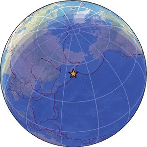
-
Comment by Juan F Martinez on Tuesday
-

Strong mag. 5.3 Earthquake - Ionian Sea, 59 km southwest of Zakynthos Island, Greece, on Tuesday, Dec 16, 2025, at 01:41 am (GMT +2)

-
-
Magnitude 5.7 Region ROTA REGION, N. MARIANA ISLANDS Date time 2025-12-15 23:06:14.7 UTC Location 14.350 ; 145.839 Depth 100 km Distance 96 km SSE of Saipan, Northern Mariana Islands / pop: 48,200 / local time: 09:06:14.7 2025-12-16
73 km SSE of San Jose Village, Northern Mariana Islands / pop: 15,000 / local time: 09:06:14.7 2025-12-16Source parameters provided by:
National Earthquake Information Center, U.S. Geological Survey -- Golden, United States (NEIC)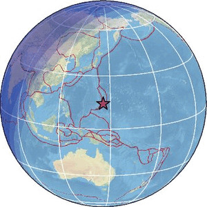 ------------------------------------------------------------------------------------------------------------------------------------------------------This one was downgraded from a 6 to a 5.6...
 -------------------------------------------------------------------------------------------------------------------------------------------------The downgraded evidence:
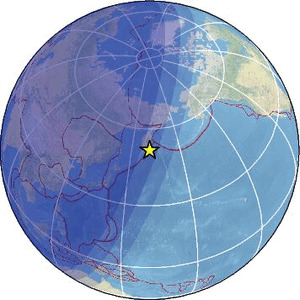
Magnitude 5.6 Region OFF EAST COAST OF KAMCHATKA Date time 2025-12-15 19:33:08.1 UTC Location 51.700 ; 161.140 Depth 45 km Distance 1651 km NE of Asahikawa, Japan / pop: 356,000 / local time: 04:33:08.1 2025-12-16
228 km ESE of Petropavlovsk-Kamchatsky, Russia / pop: 187,000 / local time: 07:33:08.1 2025-12-16Source parameters provided by:
Geophysical Survey of the Russian Academy of Sciences -- Obninsk, Russia (GSRAS)
-
-
https://www.volcanodiscovery.com/earthquakes/quake-info/22492849/in...
Very strong mag. 6.7 Earthquake - North Pacific Ocean, Hokkaido, 115 km northeast of Hachinohe, Aomori, Japan, on Friday, Dec 12, 2025, at 12:44 pm (GMT +10) - 12 hours ago

-
Comment by Mario Valencia-Rojas on December 12, 2025 at 6:21am
-
THE RING OF FIRE IS LIT UP TONIGHT | December 11, 2025
A fresh look at global seismic data shows intense activity sweeping the entire Pacific Rim. Clusters of quakes are hitting Indonesia, Japan, the Aleutians, the West Coast of the Americas, Central America, and South America all at once. Volcanic hotspots along the same arc are active at the same time. The entire system is in motion and the distribution covers every major subduction segment across the Pacific.
-
-
West Coast and San Andreas earthquakes 11.12.25.
-
-
Magnitude 6.5 Region NEAR EAST COAST OF HONSHU, JAPAN Date time 2025-12-10 14:52:24.2 UTC Location 40.905 ; 142.625 Depth 33 km Distance 159 km ENE of Aomori, Japan / pop: 298,000 / local time: 23:52:24.2 2025-12-10
105 km NE of Hachinohe, Japan / pop: 239,000 / local time: 23:52:24.2 2025-12-10Source parameters not yet reviewed by a seismologist
-
-
Magnitude 7.6 Region HOKKAIDO, JAPAN REGION Date time 2025-12-08 14:15:11.1 UTC Location 41.029 ; 142.156 Depth 47 km Distance 122 km ENE of Aomori, Japan / pop: 298,000 / local time: 23:15:11.1 2025-12-08
81 km NNE of Hachinohe, Japan / pop: 239,000 / local time: 23:15:11.1 2025-12-08Source parameters reviewed by a seismologist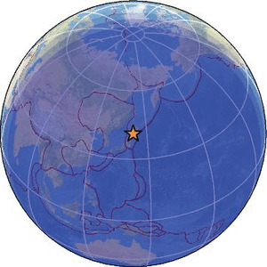
-
-
Magnitude 5.1 Region WESTERN TURKEY Date time 2025-12-08 10:21:32.4 UTC Location 37.016 ; 30.802 Depth 95 km Distance 176 km SW of Konya, Turkey / pop: 875,000 / local time: 13:21:32.4 2025-12-08
15 km NNE of Antalya, Turkey / pop: 758,000 / local time: 13:21:32.4 2025-12-08Source parameters reviewed by a seismologist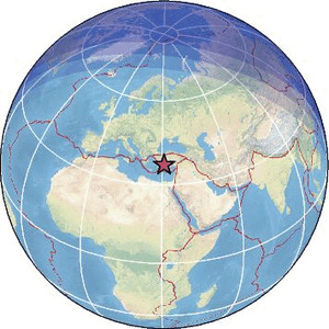
-
-
Magnitude 6.2 Region KURIL ISLANDS Date time 2025-12-07 16:34:03.8 UTC Location 50.223 ; 156.903 Depth 5 km Distance 338 km S of Petropavlovsk-Kamchatsky, Russia / pop: 187,000 / local time: 04:34:03.8 2025-12-08
74 km ESE of Severo-Kuril’sk, Russia / pop: 2,400 / local time: 03:34:03.8 2025-12-08Source parameters not yet reviewed by a seismologist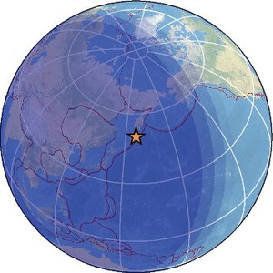
SEARCH PS Ning or Zetatalk
Nancy Lieder, Emissary of the Zetas.
https://poleshift.ning.com/xn/detail/3863141:Comment:1168188
Awakening to the Alien Presence ZetaTalk
The truth will likely never to be known to the public but be washed away in the Nibiru panic soon to engulf the world.
The Worst of the Cover-Up
https://poleshift.ning.com/profiles/blogs/the-worst-of-the-cover-up
Main Establishment Lies
https://poleshift.ning.com/profiles/blogs/main-establishment-lies
Donate
© 2025 Created by 0nin2migqvl32.
Powered by
![]()
You need to be a member of Earth Changes and the Pole Shift to add comments!
Join Earth Changes and the Pole Shift