- More than 200 people have been reported dead after a landslide hit coltan mines in the Democratic Republic of Congo.
ZetaTalk: Most Terrible Day


"The causes of landslides are not a mystery to mankind. Layers of rock and soil such that rain running along a clay or rock layer can create a slippery surface for the weight of the layers above it is a common cause. A rock jumble from previous mountain building, broken or fractured rock easily dislodged. We have stated that the earthquakes man experiences between the periodic passages of Planet X can be considered aftershocks from the last passage, and this is true of landslides also. Mountain building rumples the landscape, so the land is not flat but has steep ravines and hill sides. Older mountain ranges are recognized for their rounded or smoothed appearance, because of frequent landslides distributing the rubble.
"As we approach another passage, another Pole Shift, the pace of landslides has picked up. Why would this be? Plates under pressure will put pressure on regions that contain rumpled hillsides and deep ravines, as these give more readily than strictly flat land, thus act as a weak link. In addition, due to the wobble, the weather has gotten more extreme, with drought and deluge increasing in extremes. Dry ground, suddenly flooded with rainwater needing to seek its level as runoff, will create internal water slides between the rock and soil layers that constitute the rumpled hillsides. Is there an early warning system that mankind could use? The trembles that soil about to slide emits could be detected, yes. These are not earthquakes, and have their own frequency. "
Views: 125178
Comment
https://english.news.cn/20260208/7c939843002a4cd4af60a8789956c095/c...
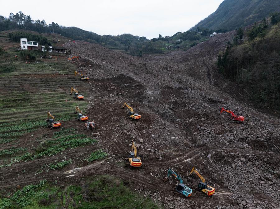
CHENGDU, Feb. 8 (Xinhua) -- Continuous rainfall-induced infiltration that softened mudstone on a high-steep slope caused a landslide in southwest China's Sichuan Province, and no direct link has been found between mining activities and the disaster, according to an investigation report released on Saturday.
The report, published by the provincial department of natural resources, identified the disaster in Jinping Village of Junlian County, under the city of Yibin, as a compound natural disaster involving a sudden high-position landslide that evolved into a long-distance debris flow.
The landslide occurred at 11:50 a.m. on Feb. 8, 2025, leaving 10 people dead, 19 missing and two injured, with direct economic losses exceeding 6 million yuan (about 862,193 U.S. dollars).
A massive rockfall in Ubrique in the province of Cádiz, Andalusia, Spain 🇪🇸 (04.02.2026)
Via https://t.me/Disaster_News
Torcross, UK
Part of the A379 coast road near Torcross in Devon has collapsed after sea defences were damaged during last month’s storms.
Residents woke up on Tuesday 3rd February to find a section of the road had washed away.
Posting on social media, the owners of The Start Bay Inn at Torcross said: “It’s a mess, like a bomb has gone off. The road to the pub on the Leyside is filled with debris and not drivable.”
Councillor Laurel Lawford said the damage was “really, really bad”.
“I’ve spoken to someone who has sent their drone over and they estimate there is approx 300 metres of damage. It’s very bad, and the drop down to the beach from the destroyed road is about 15 feet deep, I would guess…”
Massive landslide cut off the road in Pondok Balik, Central Aceh, Indonesia 🇮🇩 (01.02.2026)
Via https://t.me/Disaster_News
https://news.sky.com/story/more-than-200-killed-after-landslide-hit...
Heavy rain in the Democratic Republic of Congo leads to the collapse of mines used to extract coltan - used in phones, computers and aircraft engines.
Saturday 31 January 2026 10:35, UK

Many bodies are still buried under the mud following the tragedy near Rubaya, in the east of the country, earlier this week.
The mines are under the control of rebel group M23. Lumumba Kambere Muyisa, a spokesperson of the rebel-appointed governor of North-Kivu province, said the landslide was caused by heavy rain.
"More than 200 people were victims of this landslide, including miners, children and market women," he said. "Some people were rescued just in time and have serious injuries," he said.

A former miner at the site spoke of the dangers of repeated landslides because tunnels had been dug by hand, poorly constructed, and left without maintenance.
"People dig everywhere, without control or safety measures," Clovis Mafare said. "In a single pit, there can be as many as 500 miners, and because the tunnels run parallel, one collapse can affect many pits at once."
Sky News found children as young as four working in the unregulated mines in the DRC.
The country has been hit by violence between government forces and different armed groups, including the Rwanda-backed M23, for decades.
In May 2024, M23 seized Rubaya and took control of its mines.
Landslides sweep through a city on Italy's Sicilian island, where a massive landslide has caused entire residential neighborhoods to collapse from the slopes.
The landslide, triggered by heavy rains, extended up to 4 kilometers and is still expanding.
Thousands of residents have been evacuated from the threatened areas.
Niscemi, Italy
About 500 residents were evacuated after a landslide tore through part of the Italian town of Niscemi, damaging a key access road and raising fears the area could be cut off, according to officials.
The landslide was reported Sunday in the Sante Croci neighborhood of Niscemi, a town in Sicily, Italy’s largest island.
Authorities said the slope failure occurred near the Benefizio stream and affected a section of Provincial Road SP10, one of the main links between the area and the town center. The ground collapse was estimated at about 20 feet (6 meters).
Authorities said geological surveys were underway to determine whether the current landslide is connected to a separate slope failure reported on January 16 in another nearby area that also damaged a provincial road.
Videos in Comments: https://t.me/ZetaTalk_Followers/83057
https://www.facebook.com/share/p/1CRk7UC5kW/

At least 6 people killed and 89 are missing after a landslide in Pasirlangu, Cisarua District, West Java, Indonesia 🇮🇩
Via https://t.me/Disaster_News
https://www.aljazeera.com/news/2026/1/24/seven-dead-82-missing-afte...
Latest disaster comes just weeks after deadly floods and landslides left more than 1,000 people dead in Indonesia’s west.


Rescue teams are searching for survivors after a landslide in the West Bandung region of Indonesia’s West Java province left at least seven people dead and dozens missing, local officials have said.
“The number of missing persons is high, we will try to optimise our search and rescue efforts today,” Abdul Muhari, the spokesperson for Indonesia’s disaster mitigation agency, said on Saturday.
Indonesian news outlet Kompas said a landslide hit Pasirlangu village in West Bandung at about 2am local time on Saturday morning (19:00 GMT on Friday).
“A strong flow” of water and loose soil from the slopes of Mount Burangrang smashed into some 30 homes in the village while most of their inhabitants were sleeping, Kompas said.
Local Police Chief AY Yogaswara said the landslide was accompanied by flash flooding, according to Jakarta-based Antara news agency.
“When the incident occurred, residents heard a loud rumbling sound,” Yogaswara said.
Indonesia’s armed forces, the regional disaster management agency, volunteers, and the local community are all involved in emergency response efforts, he said.
Fearing further tragedy, local authorities have ordered the evacuation of residents in areas which are known to be prone to landslides. The area affected by the landslide on Saturday is estimated to cover some 30 hectares (74 acres), Kompas reports.
 Indonesia’s weather agency had warned of extreme weather, including heavy rains in West Java province for a week from Friday, according to reports.
Antara also reported that flooding hit 20 of the 30 sub-districts of West Java’s Karawang regency, due to the Citarum and Cibeet rivers overflowing. Regional government officials had advised residents living near the rivers to evacuate immediately, according to Antara.
Saturday’s disaster follows deadly landslides and flooding last month that left more than 1,170 people dead across Indonesia’s North Sumatra, West Sumatra, and Aceh provinces.
The Indonesian government has filed lawsuits against six companies over environmental degradation suspected of contributing to the deadly disaster.
Indonesia is facing increased risks of natural disasters due to environmental changes, including deforestation – often linked to global palm oil demand – climate change and rising sea levels.
https://timesofmalta.com/article/piece-filfla-breaks-off-duing-stor...
Experts warn stronger and more frequent storms will endanger marine and bird species

 The missing piece of Filfla on the island's eastern side. Photo: Jonathan Borg
If you gazed towards Filfla today and thought it looked a bit different than usual, that’s because it is, after a substantial piece of the tiny island off Malta’s south coast collapsed during Storm Harry earlier this week.
Photos taken by Times of Malta and from Facebook page Dwardu Photography show a missing piece and a new sheer cliff on the eastern side of the islet when compared to photos taken before the storm.
Speaking to Times of Malta, biologist Alan Deidun said that while he had not heard about the collapse, he was not surprised by it, as the rock is fragile and highly unstable.
 A close-up of the collapsed cliff face. Photo: Dwardu Photography
Not only is the islet exposed to the elements on all sides, but up until 1971 it was used by the Royal Navy and Royal Air Force for target practice. Unexploded ordnance from these bombardments can still be found on and around Filfla.
While it is mostly barren, since 1980 Filfla has also been a bird reserve. Martin Austad, the head of seabird research at Bird Life Malta, said the island is home to the biggest colony of European storm petrels (Kanġu ta' Filfla) in the Mediterranean.
“Filfla is constantly changing due to weather and sea erosion. If it were ever to be lost, it would have huge knock-on effects on the species around the world,” he said.
Austad said that the effects of climate change, which resulted in stronger and more frequent storms, together with increased construction and light pollution, were putting pressure on species of birds that roost in cliff faces, such as the Yelkouan shearwater
“Having fewer places where to lay their eggs means that colonies will be more concentrated into smaller areas, making the species more vulnerable to coastal erosion,” he said.
Meanwhile, Deidun said the worst hit marine flora and fauna during Storm Harry were those that lived in shallow areas and couldn’t move to caves or deeper waters to seek shelter, including Neptune grass (Posidonia oceanica), coral, sea urchins and other similarly immobile creatures.
“The degradation of Posidonia meadows also worsens the impact of such storms, as the grass absorbs some of the energy of the waves before they reach the shore,” he said.
Filfla was by no means the only place to face the full force of Storm Harry, which peaked on Tuesday. In Siġġiewi’s Għar Lapsi, which is located directly opposite Filfla, the storm demolished a platform popular with bathers ,as well as the lower end of a slipway and a flight of steps that lead to the cave.
https://poleshift.ning.com/forum/topics/last-trimester-event-timeline
NEW POLE SHIFT UPDATE!
Nancy Lieder November 11, 2025 ZetaTalk Chat for November 30, 2025 - Earth Changes and the Pole Shift
Nancy Lieder, Emissary of the Zetas.
https://poleshift.ning.com/xn/detail/3863141:Comment:1168188
Awakening to the Alien Presence ZetaTalk
The truth will likely never to be known to the public but be washed away in the Nibiru panic soon to engulf the world.
The Worst of the Cover-Up
https://poleshift.ning.com/profiles/blogs/the-worst-of-the-cover-up
Main Establishment Lies
https://poleshift.ning.com/profiles/blogs/main-establishment-lies
© 2026 Created by 0nin2migqvl32.
Powered by
![]()
You need to be a member of Earth Changes and the Pole Shift to add comments!
Join Earth Changes and the Pole Shift