Giant waves crash over seawalls during a storm

in the suburbs of Taipei, Taiwan. 21.10.2025

"We warned at the start of ZetaTalk, in 1995, that unpredictable weather extremes, switching about from drought to deluge, would occur and increase on a lineal basis up until the pole shift. Where this occurred steadily, it has only recently become undeniable. ZetaTalk, and only ZetaTalk, warned of these weather changes, at that early date. Our early warnings spoke to the issue of global heating from the core outward, hardly Global Warming, a surface or atmospheric issue, but caused by consternation in the core. Affected by the approach of Planet X, which was by then starting to zoom rapidly toward the inner solar system for its periodic passage, the core was churning, melting the permafrost and glaciers and riling up volcanoes. When the passage did not occur as expected in 2003 because Planet X had stalled in the inner solar system, we explained the increasing weather irregularities in the context of the global wobble that had ensued - weather wobbles where the Earth is suddenly forced under air masses, churning them. This evolved by 2005 into a looping jet stream, loops breaking away and turning like a tornado to affect the air masses underneath. Meanwhile, on Planet Earth, droughts had become more intractable and deluges positively frightening, temperature swings bringing snow in summer in the tropics and searing heat in Arctic regions, with the violence of storms increasing in number and ferocity."

ZETATALK

Wild Weather, the Wobble Effect - Earth Changes and the Pole Shift

Views: 636939

Comment

You need to be a member of Earth Changes and the Pole Shift to add comments!

Join Earth Changes and the Pole Shift

Comment by Tracie Crespo 22 minutes ago

https://www.cnn.com/2025/10/25/weather/hurricane-melissa-storm-trac...


Tropical Storm Melissa expected to explode into a Category 4 hurricane and could bring catastrophic impact to Jamaica


Satellite view of Melissa in the Caribbean Sea.

Tropical Storm Melissa is forecast to rapidly intensify into a major hurricane this weekend as it lashes Jamaica and parts of the northern Caribbean, bringing days of life-threatening, potentially catastrophic impact.

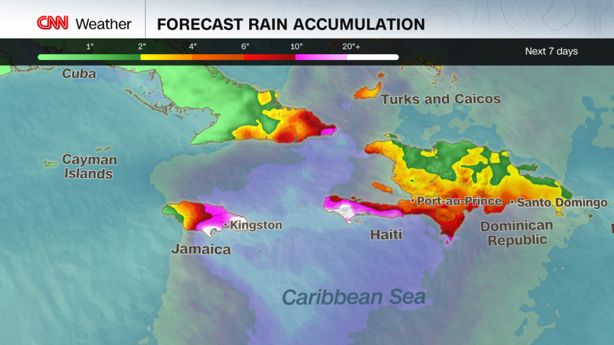
Jamaica looks to be the epicenter for the worst of Melissa’s triple threat of extreme rainfall flooding, wind damage and storm surge. Melissa could make landfall on Jamaica late Monday or early Tuesday. Haiti also continues to be in thick of Melissa’s destructive flood and landslide threats.

A hurricane warning is effect for Jamaica, where strong winds are expected to begin tonight. Southern Haiti is under a hurricane watch.

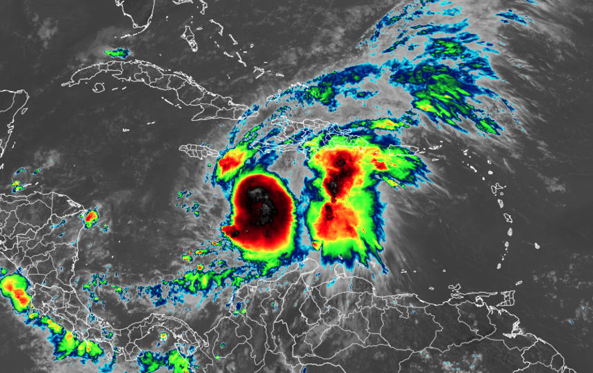
Melissa has been moving at a snail’s pace for days and it won’t pick up speed anytime soon as it tracks generally westward through Sunday night. The storm is centered 165 miles southeast of Kingston, Jamaica, and is packing winds up to 70 mph as of Saturday morning.

That slow movement has already caused problems. Torrential rain bands have swamped Haiti and the Dominican Republic for much of the week, causing flooding and triggering landslides. At least three deaths have been reported in Haiti due to the storm, two of which were the result of a landslide, the Haitian Civil Protection Agency said in a statement. In the Dominican Republic, at least one person has died and more than 1,000 people have evacuated or been displaced, officials said Friday.

Melissa is expected to rapidly intensify into a Category 4 or stronger hurricane by Sunday afternoon, ramping up its destructive wind and storm surge threats alongside the intense rain as it tracks near or south of Jamaica through early next week. Landfall as a Category 5 hurricane cannot be ruled out and Melissa could be the strongest hurricane on record to make landfall in Jamaica.

This explosive strengthening is happening more often as the world warms due to fossil fuel pollution. Three of the four Atlantic hurricanes this season underwent extreme rapid intensification: Erin, Gabrielle and Humberto.

Melissa’s extreme threats

Jamaica, Haiti and the southern Dominican Republic will face the worst of the storm into at least early next week. Next in line for strong winds, storm surge and flooding rain will be eastern Cuba, the southern Bahamas and Turks and Caicos.

AL STORM1 TROP RAIN ACCUM.png

“Extensive damage to roads and buildings is expected, potentially isolating communities for an extended period of time,” in Haiti on Saturday, the hurricane center warned. “This is a life-threatening situation and immediate preparations to protect life and property should be taken.”

Jamaica will not only endure Melissa’s torrential rain, but will also have to contend with days of ferocious winds. The nation of nearly 3 million people will likely see hurricane-force winds by Sunday or Monday. The most extreme winds will likely occur as Melissa tracks near Jamaica on Monday into Tuesday. Downed trees, power outages and structural damage could be widespread.

Officials in the country are already preparing for the worst.  All public hospitals have been in “emergency mode” since Thursday evening, halting outpatient and elective procedures to ensure more beds are open, according to Christopher Tufton, Jamaica’s Minister of Health and Wellness.

Jamaica’s airports remain open for now, but will likely close within 24 hours of a hurricane warning being issued, according to Daryl Vaz, Minister of Science, Energy, Telecommunications and Transport.

Jamaican Prime Minister Andrew Holness urged people to take the threat seriously at a Friday news conference: “You have been given enough notice that (Melissa) is coming and that it could be disastrous, so take all measures to protect yourself.”

The United States mainland is not expected to be directly threatened by Melissa. Even so, rough surf and rip currents could spread along the US East Coast next week.

Why Melissa’s forecast is so alarming

  • It’s barely moving. When a storm crawls, rainfall piles up over the same towns for days. A similar setup produced catastrophic floods in 2017 with Hurricane Harvey, which dumped over four feet of rain on parts of Texas, and in 2019 with Hurricane Dorian, which dropped nearly two feet of rain in the Bahamas and over a foot in parts of South Carolina.
  • Mountains magnify the flood threat. Haiti, Jamaica and the Dominican Republic’s steep terrain will force air upward, wringing out more moisture from the storm, just like squeezing a wet sponge, turning tropical humidity into torrents racing downhill. Mudslides are all but guaranteed in this scenario. This happened when Hurricane Helene devastated western North Carolina last year.
  • Heat in the Caribbean Sea runs deep. The Caribbean’s exceptionally-warm water extends far below the surface, preventing the usual “stirring up” of cooler water that can weaken hurricanes. Melissa is expected to feast on that deep reservoir of heat, raising the ceiling on its potential intensity.

Hurricane Beryl in July 2024 was the last storm to heavily impact Jamaica. It did not make landfall, but still lashed the island with flooding rain and strong winds as it passed to the south as a Category 4.

CNN Meteorologists Briana Waxman and Mary Gilbert contributed to this report.

Comment by Juan F Martinez 22 hours ago

Flooding in the city of Taiping, Malaysia. 23.10.2025.

VIDEO: https://t.me/ZetaTalk_Followers/78351

ZetaTalk: Malaysia
Malaysia stands in the path of rushing water, which will drown even the mainland country of Thailand during the pole shift. Several factors will create a rush of water over the Malaysian peninsula. When the crust of the Earth stops its slide and the plates begin to slam into each other, the Pacific will shorten, and the India/Australia plate will subduct violently into the Himalayas. As this occurs, there will be a drop in sea level over India, the waters about India rushing in to fill the gap. Likewise, the Pacific will compress, so the sea level there is relatively higher, and as water seeks an even level this water will rush into the gap over the hapless and drowning India. The Malaysian peninsula stands in the path of this rush, and once water begins to move, it creates its own force, such that there is a press of water moving in the direction of India, and this pressure will be great enough to create tidal bore that will go up and over any mountains in its path. Malaysia, and other countries in the path of this flood, will utterly drown. Malaysia is riding on the tongue of the Eurasian Plate and will suffer when plate movements occur prior to the pole shift. The Malaysia peninsula is lowland, and any reduction in sea level is devastating.

ZetaTalk ™

More: Indonesia Elevation Loss
https://www.zetatalk.com/info/tinfx341.htm

Comment by Tracie Crespo yesterday

https://www.nst.com.my/news/nation/2025/10/1301229/heavy-rain-high-...

Heavy rain, high tide cause worsening floods in Perak

By Zahratulhayat Mat Arif
October 24, 2025 @ 5:05amtwitter sharing button
whatsapp sharing button

TAIPING: The main cause of flooding in the affected areas of Perak is the continuous heavy rainfall combined with the high tide.

State Infrastructure, Energy, Water and Public Transport Committee chairman Datuk Seri Mohammad Nizar Jamaluddin said the existing drainage and irrigation systems could no longer accommodate the runoff, resulting in overflow.

"Hydrological data from the affected areas recorded a significant and continuous increase in rainfall over an extended period, with total rainfall exceeding 50mm.

"The rainfall recorded at several stations in the districts of Larut, Matang and Selama, and Kerian equalled or exceeded the average monthly rainfall for October — particularly at the Pondok Tanjung Station (244.5mm), Bukit Larut (136mm), and Sungai Kurau Batu 14 (174mm).

"The heavy and prolonged downpour that afternoon, coinciding with the high tide phenomenon, further worsened the situation in the districts of Kerian; Larut, Matang and Selama; as well as Manjung," he said.

He said that to reduce the risk and impact on residents in the affected districts, the Department of Irrigation and Drainage deployed two boats to assist in the rescue of flood victims.

"Continuous and periodic monitoring of flood-affected areas is being carried out, along with the immediate activation and installation of mobile pumps to reduce stagnant water in low-lying areas," he said.

He added that the state government also urged all parties, including local authorities and the local community, to work together to ensure that drainage systems remain clean and free from blockages caused by garbage or waste materials.

Meanwhile, Nizar said the release of water from the Bukit Merah Dam was necessary to maintain the dam's structural integrity and ensure public safety following continuous heavy rainfall since Wednesday.

He said prolonged downpours in the dam's upper catchment areas had caused a sharp rise in water levels.

"This prompted the Department of Irrigation and Drainage to initiate controlled water discharge in accordance with the dam's Standard Operating Procedure and Emergency Action Plan.

"Between 6pm and 9pm yesterday, the inflow rate surged from 61.8 cubic metres per second to 200 cubic metres per second, and remained high until the next morning.

"The dam's water level also rose from 28.65ft— the normal level — to 30.0ft, which is at the danger mark," he said in a statement today.

Nizar said the release was a necessary preventive measure to stabilise the dam after the inflow rate into the Bukit Merah reservoir became excessively high within a short period.

"The step was crucial to ensure the dam remains safe and continues to function optimally.

"It was carried out in line with standard procedures after taking into account both the inflow rate and dam safety factors," he added.

He said the state government would continue to monitor the downstream effects of the release and coordinate with the Kerian District Disaster Management Committee should there be any risk of flooding.

"The public is advised to stay alert and follow instructions from the authorities as the situation develops," he said.

Comment by Juan F Martinez yesterday

Strong wind gusts reaching up to 28 meters per second swept through Wellington, New Zealand, knocking a girl off her feet and tossing her onto the roadway.

VIDEO:  https://t.me/ZetaTalk_Followers/78325

Comment by Juan F Martinez on Tuesday

Giant waves crash over seawalls during a storm in the suburbs of Taipei, Taiwan. 21.10.2025.

VIDEO: https://t.me/ZetaTalk_Followers/78286

Comment by Juan F Martinez on October 18, 2025 at 8:58pm

A van loaded with people is seen washed away down a river during intense rains and flash floods in Idukki district, India, Kerala state. 17.10.2025.

VIDEO: https://t.me/ZetaTalk_Followers/78153

Comment by Tracie Crespo on October 18, 2025 at 3:33pm

https://mexiconewsdaily.com/news/mexicos-devastating-floods/

A week after Mexico’s floods, the death toll is at 72 and dozens remain missing

Mudslides and damaged bridges have left several regions isolated, particularly in the state of Hidalgo northeast of Mexico City and in the Gulf Coast state of Veracruz. Infrastructure, Communications and Transportation Minister Jesús Esteva said 127 towns remain virtually inaccessible as of Thursday night.

PROTESTERS IN XALAPA
The post-flood actions in Veracruz have reached the protest stage, with those accused of an inadequate response including Gov. Rocío Nahle and, in the case seen here, authorities of the Veracruz University, where some students are said to be among the missing. (Yerania Roló/Cuasrtoscuro.com)

Esteva said his ministry is documenting and mapping the damage to facilitate rescue and recovery operations, while more than 8,000 soldiers are working in the affected areas to search for the missing and remove debris.

The Defense Ministry has been operating around the clock, tasking 21 helicopters with deliveries and medical supplies, especially to isolated regions of Hidalgo and Veracruz.

Esteva said the government is working with some urgency as the weekend weather forecast indicates a cold front will be moving in, bringing with it heavy rain, though the storms are projected to be south of the areas affected by last week’s flooding.

Veracruz, the state hardest hit by the flooding, has reported 32 fatalities with 14 residents counted as missing, followed by Hidalgo (21 dead) and Puebla (18).

Veracruz Governor Rocío Nahle is facing growing criticism for her handling of the disaster. On Thursday, she insisted that the state Civil Protection agency did issue an early alarm and thousands were evacuated, “although some residents preferred to remain in their homes.”

Some residents insist no such alarm sounded

While on Friday Nahle said her administration would work to make sure all families affected by the disaster are safe and secure, one columnist pointed out that the governor canceled the state’s natural disaster insurance policy.

Near Poza Rica, Veracruz, where thousands are without shelter and fetid water remains ankle deep, residents in the area are voicing concern about the potential spread of typhoid fever and cholera.

In Puebla, government officials are working to find accommodations for more than 200 people who lost everything in the flooding. Although nearly 2,000 people have left state-run shelters in hopes of salvaging their homes and property, dozens of families face an uncertain future.

The newspaper Milenio reported that the state is preparing to close down the shelters, but more than 200 people who lost everything — primarily campesinos — say they have nowhere to go. 

“We are just simple farmers. We have no wages, no other means of support except whatever help the government might provide,” said Jesús Hernández, a resident of Colonia Los Manguitos who was in a shelter in the municipality of Xicotepec with his wife and several grandchildren. 

North of the impacted areas in the state of Tamaulipas, residents of Tampico and Ciudad Madero along the Gulf Coast are taking precautions as the Pánuco River has reached critical levels. 

The National Water Commission (Conagua) has sought to assuage concerns, reporting late Thursday that flood stage would not be reached for another 80 hours, and only if conditions worsen. For now, Conagua said, the forecast is not cause for alarm.

Even so, the state Water Resources Ministry has ordered Civil Protection agents to take preventive measures in low-lying areas of the adjacent municipalities.

With reports from El UniversalLa JornadaProceso and Milenio

Comment by Tracie Crespo on October 17, 2025 at 3:38pm

https://apnews.com/article/alaska-typhoon-evacuation-village-airlif...

Evacuees detail harrowing scenes of flooding in coastal Alaska villages as airlift continues


From the lone dry room where Alexie Stone and his brothers and children gathered, he could look outside and see under the water, like an aquarium. A shed drifted toward them, threatening to shatter the glass, but turned away before it hit.

The house came to rest just a few feet away from where it previously stood, after another building blocked its path. But it remains uninhabitable, along with most of the rest of Stone’s Alaska Native village of Kipnuk, following an immense storm surge that flooded coastal parts of western Alaska, left one person dead and two missing, and prompted a huge evacuation effort to airlift more than 1,000 residents to safety.

“In our village, we’d say that we’re Native strong, we have Native pride, and nothing can break us down. But this is the hardest that we went through,” Stone said Thursday outside the Alaska Airlines Center, an arena in Anchorage, where he and hundreds of others were being sheltered. “Everybody’s taking care of everybody in there. We’re all thankful that we’re all alive.”

Additional articles: 

https://www.theguardian.com/us-news/2025/oct/16/alaska-typhoon-halo...

https://www.nbcnews.com/news/us-news/alaska-works-rescue-storm-vict...

https://alaskabeacon.com/2025/10/16/in-photos-tears-and-uncertainty...

Alaska Typhoon Aftermath

Comment by Juan F Martinez on October 17, 2025 at 4:21am

Waitomo, New Zealand—Aerial images have revealed the extent of damage caused by flooding earlier this week.

On Tuesday, some communities in parts of the central North Island were cut off as torrential rain caused widespread flooding, slips, and extensive road closures.  Repairs were "likely to take years and cost millions of dollars", the council said.

More: https://t.me/ZetaTalk_Followers/78062

Comment by Juan F Martinez on October 17, 2025 at 1:36am

A powerful tornado struck Sijangkang in the Kuala Langat District, Malaysia, 15.10.2025.

VIDEO: https://t.me/ZetaTalk_Followers/78055

Wild Weather, the Wobble Effect
https://poleshift.ning.com/profiles/blogs/wild-weather

SEARCH PS Ning or Zetatalk

 
Search:

This free script provided by
JavaScript Kit

Donate

Donate to support Pole Shift ning costs. Thank you!

© 2025   Created by 0nin2migqvl32.   Powered by

Badges  |  Report an Issue  |  Terms of Service