


Deadly wildfire razes entire town in Chile: 'Literally like Dante's Inferno'
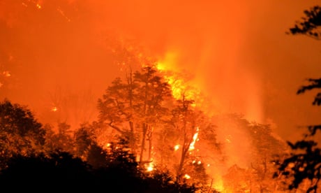
An entire town has been consumed by flames in Chile as unusually hot, dry weather undermined efforts to combat the worst forest fires in the country’s recent history.
One body was later recovered from the ruins. Two people are missing, but most of the residents were evacuated unharmed. Few will have a home to return to.
Drone images showed entire neighbourhoods reduced to ashes. The roads are still neatly symmetrical, but the buildings in block after block lie in smouldering ruins under a hazy sky.
Even for a region that is frequently hit by earthquakes and floods, the extent of the destruction was shocking.
“Nobody can imagine what happened in Santa Olga. What we have experienced here is literally like Dante’s Inferno,” said the Carlos Valenzuela, the mayor of the encompassing municipality Constitución. “We were recovering after the last earthquake, but this tragedy has messed up everything.”
He said the smaller communities of Putú and Cabezalillo had also been damaged.
“The situation is awful. It’s the worst catastrophe we’ve had in a number of years. I believe that this surpasses any tragedy that we have had before, this is much worse than when it was the earthquake or the floods. It is a thing that does not stop, is advancing,” said Francisco Henríquez, director of Orca Chile, a civil organisation deployed in the area.
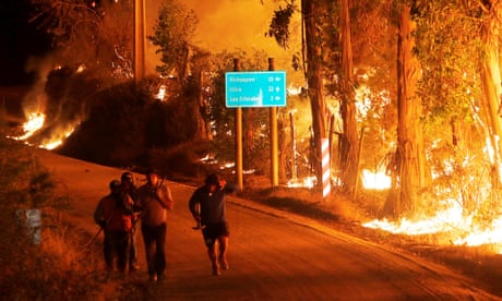
Residents expressed dismay and fury as they returned to charred livestock, collapsed buildings and blackened farm fields. Some felt abandoned by the authorities.
“When the politicians need our votes they come here, they put their face and expect us to vote for them. Now they’re not here,” Miguel Reyes, a resident of Santa Olga, told BioBioChile
But even with 5,000 firefighters, government resources have been overstretched.
More than 90 wildfires have broken out in the past few weeks and spread rapidly across vegetation that has been dried by unseasonably high temperatures. Many regions have suffered heatwaves. Santiago registered a record 37C on Wednesday.
At least four firefighters have been killed in the battle to control the blazes. Including police and civilians, the overall death toll is now seven, according to local media.
The economic impact is still to be calculated. According to the National Forestry Corporation, 238,000 hectares of forests in central and southern Chile have been burned, forcing the evacuation of at least 4,000 people and damaging farms, cattle ranches and vineyards.
President Michelle Bachelet has declared a state of emergency and called for international help in dealing with fire on a scale “never seen in the history of Chile”. Dozens of helicopters, light aircraft and a Boeing 747 “supertanker” have dumped water and flame retardants from the skies, but at least 30 fires continue to rage.
There have been successes. Penco, a town of 50,000 inhabitants, in the region of Bío Bío, was saved by firebreaks that kept the advancing flames at bay. But the threat continues.
The interior minister, Mahmud Aleuy, warned more fires might break out because weather forecasters predict several more days of high temperatures, strong winds and low humidity.
The government has pledged to investigate the cause of the fires and the effectiveness of the official response.
As well as climate change, tourist negligence and poor park management, the country’s timber and wood pulp industry may come under the spotlight.
Biologists say plantations of non-indigenous forests, such as eucalyptus and pine, help to spread the fires more quickly.
“About 42% of the forest fires are in plantation forests, which are like matchboxes,” said Mary Kalin Arroyo of the University of Chile. “They spread fire to native forests.”
")
 Torrential downpours caused rivers to overflow in central Bolivia and southern Peru


You need to be a member of Earth Changes and the Pole Shift to add comments!
Join Earth Changes and the Pole Shift