Giant waves crash over seawalls during a storm

in the suburbs of Taipei, Taiwan. 21.10.2025

"We warned at the start of ZetaTalk, in 1995, that unpredictable weather extremes, switching about from drought to deluge, would occur and increase on a lineal basis up until the pole shift. Where this occurred steadily, it has only recently become undeniable. ZetaTalk, and only ZetaTalk, warned of these weather changes, at that early date. Our early warnings spoke to the issue of global heating from the core outward, hardly Global Warming, a surface or atmospheric issue, but caused by consternation in the core. Affected by the approach of Planet X, which was by then starting to zoom rapidly toward the inner solar system for its periodic passage, the core was churning, melting the permafrost and glaciers and riling up volcanoes. When the passage did not occur as expected in 2003 because Planet X had stalled in the inner solar system, we explained the increasing weather irregularities in the context of the global wobble that had ensued - weather wobbles where the Earth is suddenly forced under air masses, churning them. This evolved by 2005 into a looping jet stream, loops breaking away and turning like a tornado to affect the air masses underneath. Meanwhile, on Planet Earth, droughts had become more intractable and deluges positively frightening, temperature swings bringing snow in summer in the tropics and searing heat in Arctic regions, with the violence of storms increasing in number and ferocity."

ZETATALK

Wild Weather, the Wobble Effect - Earth Changes and the Pole Shift

Views: 636789

Comment

You need to be a member of Earth Changes and the Pole Shift to add comments!

Join Earth Changes and the Pole Shift

Comment by KM on January 28, 2017 at 12:47pm

http://www.newindianexpress.com/nation/2017/jan/27/kashmir-witnesse...

Kashmir witnesses record snowfall, 11-feet snow depth in avalanche-hit Gurez

File picture of vehicles moving towards Jammu-Srinagar highway closed due to heavy snowfall in Kashmir valley. 


SRINAGAR: The snowfall in Kashmir in last few days has broken the record of over two decades.

A Meteorological department official said Kashmir has recorded heavy snowfall this year.

He said it was the heaviest snowfall recorded in the valley since 1992.

 “We had witnessed major snowfall in 1992 and 2006 but the present snowfall has broken the record of last 25 years,” the official said.

The upper reaches of the Valley including Keran, Karnah, Gurez, Machil, Tanghdar, Uri, Gulmarg, Yousmarg, Pahalgam, Sonarmarg have witnessed heavy snowfall. The ski resort of Gulmarg has recorded more than 7 ft of snowfall while Gurez, which has witnessed at least three snow avalanches in 72 hours, has experienced about 11 ft of snowfall.

The plains including Srinagar have also experienced heavy snowfall.

Many of the inter-district roads in the Valley are disconnected and there has also been breakdown of electricity with North Kashmir being the worst hit.

As was predicted by the weatherman, the weather conditions improved today after three days of continuous snowfall.

Due to improvement in weather conditions, the air traffic at Srinagar airport resumed today after remaining suspended for three days.

An airport official said there was a significant improvement in visibility and weather conditions today.

“Due to marked improvement in visibility, all the flights took off and landed at Srinagar airport today,” he said adding an additional flight was also operated today for the stranded passengers.

However, the Srinagar-Jammu national highway, the only link road connecting Kashmir with rest of the Valley, remained closed for all kinds of vehicular traffic for the 4th consecutive day today.

A traffic police official said snow avalanches hit the highway at Shaitani Nallah while the continuous rain and snowfall triggered landslides at many places including Digdol and Chesma, hampering the efforts to make the road traffic worthy.

He said it will take some time for the Border Roads Organisation (BRO), which is looking after maintenance of the highway, to make the road traffic worthy because there is snow depth of 10-12 feet at some places.

He said no fresh traffic would be allowed on the highway unless all the obstructions all cleared and road made traffic worthy.

Due to closure of Srinagar-Jammu national highway, the prices of essential commodities have shot up here and Valley is also facing shortage of cooking gas.

Valley is totally dependent on the highway for the supplies.

Comment by KM on January 27, 2017 at 12:26pm

http://www.aljazeera.com/news/2017/01/floods-lash-bolivia-peru-1701...

Floods lash Bolivia and Peru

Torrential rains lead to widespread flooding across parts of central South America.

Torrential downpours caused rivers to overflow in central Bolivia and southern Peru 

The past few days have seen flooding across parts of South America. Chile has been badly affected. So too have Bolivia and Peru.

Central Bolivia has been pounded by torrential downpours which have caused severe flooding, destroying homes and causing at least one injury.

La Paz had 24mm of rain on Wednesday, and 37mm in the past two days. This makes up more than a quarter of the January average which is 137mm.

The rainfall was a good deal heavier 380km to the east of the capital. The rain fell intensely for 10 minutes, causing rivers to overflow near the town of Villa Pagador in Cochabamba.   

This is the third time in recent years a severe flood has hit the town. The water coursed down from the top of the hill, dragging stones, branches and mud.

Witnesses said the driver of a minibus was injured when the river dragged his vehicle for more than 50 metres.

"The water flipped the vehicle several times.  We thought that the driver was dead but he was just a little banged up and now is in the hospital," said a resident.

The local government said that emergency crews were deployed to assist affected residents.

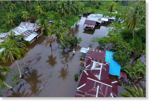
It was a similar picture across the border in southern Peru, where heavy rain caused widespread flooding in the city of Ica. Here rivers bursting their banks as authorities told residents to brace themselves for more bad weather

The areas of Tinguina and Parcona were badly affected. The water has covered several blocks in the city, reaching a depth of 70cm in places according to local media reported.

The town of San Idelfonso, which is lies next to the river, was the most affected. Strong muddy water currents were seen crashing down city streets.

Meanwhile, the town of Pisco, located to the south of capital Lima, has also being hit by mudslides after heavy rainfall.

Residents were seen trying to remove slushy mud from inside their homes. This comes after a recent drought.

The National Service of Meteorology and Hydrology, Senahmi, reported that heavy rains will continue and will increase in the coming months, until April, affecting the centre and south of the country. More landslides are also seen as possible.

Comment by KM on January 27, 2017 at 12:24pm

http://www.ctvnews.ca/canada/after-ice-storm-57-000-households-stil...

After ice storm, 57,000 households still without power in N.B.

The images are strikingly beautiful: crystalline layers of ice coating trees, homes and power lines. But for the more than 57,000 households are still without power in New Brunswick, this week’s ice storm has been a cold and dark nightmare.

“Right now, our priority is making sure that everybody is safe,” New Brunswick Premier Brian Gallant told CTV Atlantic from a recently-opened warming centre in the province. “Everybody knows exactly what they can do to stay safe, and of course that we get everybody their electricity as quickly as possible.”

The ice storm that swept through the province began on Tuesday, with some of the heaviest freezing rain and ice hitting New Brunswick’s Acadian Peninsula Wednesday night.

On New Brunswick’s frozen streets, broken branches dangle from powerlines, ice-heavy trees have fallen and split, and in some cases, the weight of the accumulated ice has been enough to snap wooden hydro poles. In affected areas, falling tree limbs and ice has created a steady percussive cacophony.

At the peak of the storm, more than 133,000 households were without power in the province. Crews have been toiling non-stop to get people back on the grid, but the work is so complex that NB Power says that they can’t guarantee a restoration time at this point. More than half of affected households -- particularly those in Moncton and the Acadian Peninsula -- are still in the dark. NB Power is urging customers to remain patient.

In addition to 271 crews from NB Power, help is also coming from Maine, Quebec and Nova Scotia.

“Once we get there, we'll meet up with the supervisor from the team from that area and he’ll give us further direction,” Nova Scotia Power field supervisor Bruce Allen told CTV Atlantic as a convoy of 11 trucks headed towards the ice-caked city of Miramichi.

With widespread power outages, warming centres have been opened across the province and will keep their doors open as long as people are still without electricity.

Tired of bundling up at home, Amy Mather and her young son checked into one on Thursday.

“He's sick, so I don’t want him to get any worse,” Mather told CTV Atlantic.

At one warming centre, a Syrian refugee family were also among the dozens of people who showed up to escape the cold.

“This is their first winter,” the family’s sponsor, Wayne Mullin, told CTV Atlantic. “They arrived in February and the weather, as you recall last winter, was quite good and so they really didn't get a true taste of winter -- and they're getting it now.”

In Moncton, the local YMCA also invited in those affected by the storm.

“We opened up our doors and we said anybody that's in a situation that they have no electricity and no hot water to come down to the Y,” YMCA of Greater Moncton CEO Zane Korytko told CTV Atlantic. “They can warm up, they can come and take a hot shower and they can have a cup of coffee or tea, all on us.”

Authorities are warning people to be aware of falling ice and reminding residents of affected areas to avoid standing under telephone wires or trees. NB Power is also warning people to stay away from downed hydro lines.


Comment by KM on January 26, 2017 at 1:03pm

http://www.straitstimes.com/asia/se-asia/more-than-9000-people-evac...

More than 9,000 people evacuated in Johor floods

Floodwaters hit houses in a Perak village as three days of relentless rain in Malaysia brought floods to nine of the country's 13 states.

JOHOR BARU • Johor state was the worst hit as three days of relentless rain in Malaysia brought floods to nine of the country's thirteen states. More than 9,000 people were evacuated from their homes in Johor as at noon yesterday, mainly from Segamat and Kota Tinggi, as anxious residents hoped they would not see a repeat of the severe state floods in 2006 and 2011 which affected 40,000 people.

Segamat district, in the northern part of the state and a 21/2-hour drive from state capital Johor Baru, was the worst affected. More than two-thirds of the flood evacuees were in Segamat, and many of its roads were closed to light vehicles.

A Labis resident, Mr Chia, 59, said he hopes that this Chinese New Year will not be reminiscent of that in 2011, when he spent the festive period at an evacuation shelter.

"I remember the welfare department and volunteers bringing us mandarin oranges but nobody was in the mood to celebrate," he said.

According to Malaysia's Meteorological Department (MetMalaysia), Johor will see isolated thunderstorms in the afternoon over the Chinese New Year weekend, but no rain in the morning or at night.

While the main highways between Singapore and Kuala Lumpur were unaffected by the heavy rain, floodwaters of up to 1m high have submerged some roads in Segamat, including Jalan Jabi-Bukit Tempurung, Jalan Utama Felda Pemanis, Jalan Segamat-Kuantan (Tun Razak Expressway) and Jalan Felda Kemelah. Roads in Kota Tinggi and Kluang also saw some flooding.

Meanwhile, the floods in Selangor, Perak, Malacca, Kelantan, Sabah, Sarawak, Pahang and Negeri Sembilan brought almost 4,000 people to relief centres and shut nine schools.

MetMalaysia has predicted some rain this weekend in several places in the states along the east coast, western Sarawak and eastern Sabah in the mornings and evenings.

Rain is also on the cards in one or two places in Kedah, Perak, Pahang and Labuan, it said in a statement.

Comment by KM on January 25, 2017 at 4:06pm

http://floodlist.com/australia/french-polynesia-tahiti-moorea-janua...

French Polynesia – 100 Homes Destroyed, Airport Closed After Flooding in Tahiti and Moorea

Flooding affected parts of French Polynesia from 22 January 2017 after a period of heavy rain.

Over 200 mm of rain in 24 hours was recorded in Thaiti-Faa’a on Tahiti island between 22 and 23 January. Further warnings for heavy rain have been issued until at least 24 January, in particular for the islands of Tahiti and Moorea which have been the worst hit so far.

More than 100 houses have been destroyed. At least 3 people have been injured, one of them seriously. All schools in affected areas have been closed.

Around 300 households have evacuated their homes, with local authorities providing tents for temporary accommodation. At one point 6,000 people were left without power.

Major roads have been damaged or blocked by landslides and the military has been drafted in to help clear roads and repair damaged facilities.

Tahiti’s international airport has been closed as a result of the flooding and will remain so until at least Tuesday. Helicopter relief and rescue operations however have not been affected.

In a statement made on 23 January, the High Commissioner for French Polynesia called on the population to comply strictly with the weather warnings and security instructions limiting travel. The High Commissioner has been in contact with the mayors and local officials of some of the affected communities including Pirae, Pape’ete, Puna’auia, Mahina and Faa’a.

Floods in French Polynesia, January 2017. 


Comment by lonne rey on January 25, 2017 at 3:05pm

With latest storm, Boise surpasses all-time record for snowfall so far this season

http://www.idahostatesman.com/news/weather/article128183704.html

With an additional 3 inches by Monday afternoon, Boise claimed the No. 1 spot for snow by this date in any year since the NWS started keeping records, meteorologist Dave Groenert.

The extra inches that fell Monday put the year-to-date snowfall total at 35.5 inches, ahead of the 35.1 inches that fell between Oct. 1 and Jan. 23 in the winter of 1985-1986.

A recent roof collapse at Partners Produce in Payette.

Comment by lonne rey on January 25, 2017 at 2:15pm

'Dream' winter conditions, except it's summer

http://www.nzherald.co.nz/nz/news/article.cfm?c_id=1&objectid=1...

Whatever happened to summer? Cardrona Alpine Resort woke up to its heaviest summer snowfall in living memory yesterday, 30cm covering the base.

Cardrona Resort marketing executive Matt McIvor said: "If this had been a winter's day we would have been calling it dream conditions; it's perfect powder snow."

This was the resorts fourth snowfall in a month. Photo / Supplied via Matt McIvor, Cardrona Alpine Resort

Comment by Gerard Zwaan on January 24, 2017 at 9:29am

test

Comment by Juan F Martinez on January 24, 2017 at 3:41am

Drenched: How L.A. went from bone-dry to 216% of normal rainfall in...

Sunday’s huge storm — which dumped nearly 4 inches of rain in some areas — is part of a wetter trend that began in the fall. Since Oct. 1, downtown L.A. has received more than 13 inches of rain -- 216% of normal for this period, which the National Weather Service said was 6.26 inches.

It’s a remarkable turnaround.  Source : LA Timeshttp://www.latimes.com/local/lanow/92403525-132.html

Comment by Stanislav on January 23, 2017 at 9:52pm

Storms generate 34-foot wave, a new record for Central California coast

Source: twitter.com

22 January, 2017. The latest storms to hit California have broken records.

According to the National Weather Service, monster surf on Saturday set a new wave height record for the Monterey Bay: 34.12 feet.

The previous record was 32.8 feet, set in 2008.

High surf was also reported across the Central Coast and north of San Francisco.

The powerful surf smashed the remains of a famed concrete ship, the S.S. Palo Alto, in the Monterey Bay town of Aptos. Source: latimes.com

SEARCH PS Ning or Zetatalk

 
Search:

This free script provided by
JavaScript Kit

Donate

Donate to support Pole Shift ning costs. Thank you!

© 2025   Created by 0nin2migqvl32.   Powered by

Badges  |  Report an Issue  |  Terms of Service