"We warned at the start of ZetaTalk, in 1995, thatunpredictable weather extremes, switching about from drought to deluge,would occur and increase on a lineal basis up until the pole shift. Where this occurred steadily, it has only recently become undeniable. ZetaTalk, and only ZetaTalk, warned of these weather changes, at that early date. Our early warnings spoke to the issue of global heating from the core outward, hardly Global Warming, a surface or atmospheric issue, but caused by consternation in the core. Affected by the approach of Planet X, which was by then starting to zoom rapidly toward the inner solar system for its periodic passage, the core was churning, melting the permafrost and glaciers and riling up volcanoes. When the passage did not occur as expected in 2003 because Planet X had stalled in the inner solar system, we explained the increasing weather irregularities in the context of the global wobble that had ensued - weather wobbles where the Earth is suddenly forced under air masses, churning them. This evolved by 2005 into a looping jet stream, loops breaking away and turning like a tornado to affect the air masses underneath. Meanwhile, on Planet Earth, droughts had become more intractable and deluges positively frightening, temperature swings bringing snow in summer in the tropics and searing heat in Artic regions, with the violence of storms increasing in number and ferocity."
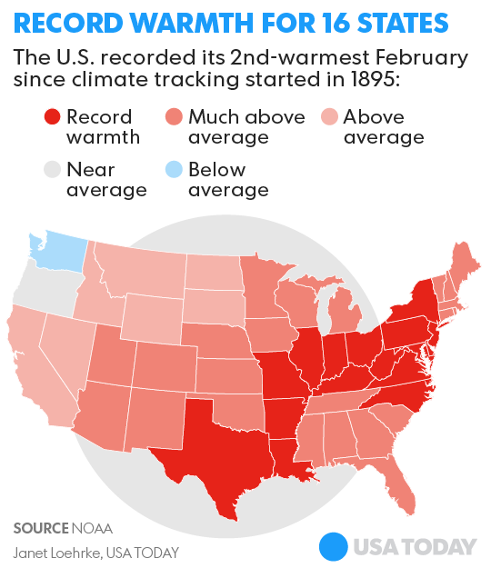
The wobble seems to have changed, as the temperature in Europe suddenly plunged after being like an early Spring, Alaska has its coldest temps ever while the US and much of Canada is having an extremely mild winter. India went from fatal cold spell to balmy again. Has the Earth changed position vs a vs Planet X to cause this?[and from another]Bitter cold records broken in Alaska - all time coldest record nearly broken, but Murphy's Law intervenes[Jan 30]http://wattsupwiththat.com/2012/01/30/bitter-cold-records-broken-in-alaskaJim River, AK closed in on the all time record coldest temperature of -80°F set in 1971, which is not only the Alaska all-time record, but the record for the entire United States. Unfortunately, it seems the battery died in the weather station just at the critical moment. While the continental USA has a mild winter and has set a number of high temperature records in the last week and pundits ponder whether they will be blaming the dreaded "global warming" for those temperatures, Alaska and Canada have been suffering through some of the coldest temperatures on record during the last week.
There has been no change in the wobble pattern, the wobble has merely become more severe. Nancy noted a Figure 8 format when the Earth wobble first became noticeable, in early 2005, after Planet X moved into the inner solar system at the end of 2003. The Figure 8 shifted along to the east a bit on the globe between 2005 and 2009, (the last time Nancy took its measure) as Planet X came closer to the Earth, encountering the magnetic N Pole with a violent push earlier in the day. But the pattern of the Figure 8 remained essentially the same. So what changed recently that the weather patterns became noticeably different in late January, 2012?
The N Pole is pushed away when it comes over the horizon, when the noon Sun is centered over the Pacific. This regularly puts Alaska under colder air, with less sunlight, and thus the historically low temps there this January, 2012 as the wobble has gotten stronger. But by the time the Sun is positioned over India, the N Pole has swung during the Figure 8 so the globe tilts, and this tilt is visible in the weather maps from Asia. The tilt has forced the globe under the hot air closer to the Equator, warming the land along a discernable tilt demarcation line.
The next loop of the Figure 8 swings the globe so that the N Pole moves in the other direction, putting the globe again at a tilt but this time in the other direction. This tilt is discernable in weather maps of Europe, again along a diagonal line. Depending upon air pressure and temperature differences, the weather on either side of this diagonal line may be suddenly warm or suddenly cold. The tilt and diagonal line lingers to affect much of the US and Canada, but the Figure 8 changes at this point to be an up and down motion, pulling the geographic N Pole south so the US is experiencing a warmer than expected winter under a stronger Sun. Then the cycle repeats, with the magnetic N Pole of Earth pushed violently away again as the Sun is positioned over the Pacific.
Would the Zetas be able to let us know what is causing the early break-up of the Arctic Ice, the ice seems to have taken on a swirling pattern at the same time, would this be wobble related?[and from another]http://www.vancouversun.com/news/national/Canada+Arctic+cracks+spec... The ice in Canada’s western Arctic ripped open in a massive “fracturing event” this spring that spread like a wave across 1,000 kilometres of the Beaufort Sea. Huge leads of water – some more than 500 kilometres long and as much as 70 kilometres across – opened up from Alaska to Canada’s Arctic islands as the massive ice sheet cracked as it was pushed around by strong winds and currents. It took just seven days for the fractures to progress across the entire area from west to east.[and from another]http://earthobservatory.nasa.gov/IOTD/view.php?id=80752&src=iot... A high-pressure weather system was parked over the region, producing warmer temperatures and winds that flowed in a southwesterly direction. That fueled the Beaufort Gyre, a wind-driven ocean current that flows clockwise. The gyre was the key force pulling pieces of ice west past Point Barrow, the northern nub of Alaska that protrudes into the Beaufort Sea.
The Figure 8 formed by the N Pole during the daily Earth wobble has shifted somewhat to the East, due to Planet X positioned more to the right of the Earth during its approach. This was anticipated, and well described in ZetaTalk, the Earth crowding to the left in the cup to escape the approach of Planet X, so the angle between these two planets would change slightly. This shift of the Figure 8 to the East is due to the push against the Earth’s magnetic N Pole occurring sooner each day than prior. Thus instead of occurring when the Sun is high over the Pacific, over New Zealand, it is now occurring when the Sun is high over Alaska. All the wobble points have shifted eastward accordingly.
This has brought a lingering Winter to the western US, and a changed sloshing pattern to the Arctic waters. Instead of Pacific waters being pushed through the Bering Straits into the Arctic when the polar push occurs, the wobble is swinging the Arctic to the right, and then later to the left, creating a circular motion in the waters trapped in the Arctic. Since the Earth rotates counterclockwise, the motion also takes this path. This is yet another piece of evidence that the establishment is hard pressed to explain. They are attempting to ascribe this to high pressure and wind, all of which are not new to the Arctic, but this circular early breakup of ice in the Arctic is new.
People from Texas to Ohio are bracing for a long-duration ice storm that could turn destructive and cut power to hundreds of thousands from Friday to Sunday.
A shallow layer of cold air in the atmosphere will accompany a storm over the central United States. The storm will produce a swath of freezing rain along a 1,000-mile swath.
As the chilled rain falls on cold surfaces, it will freeze into a glaze of ice.
Comment by Gerard Zwaan on January 11, 2017 at 10:16pm
And this for Belgium:
Crisis on the coast: worst storm in 50 years coming
Comment by lonne rey on January 11, 2017 at 9:56pm
Winds of 129mph leave a trail of destruction across Britain cutting power to 4,300 homes, hurling trampolines onto train lines and tearing roofs from buildings - and now the Big Chill is set to strike
TWO colossal swathes of churning, freezing air will close in on Britain over the next 18 hours triggering snow across the whole of the UK and the worst nationwide freeze for six years.
The entire country is on alert for crippling blizzards, Arctic temperatures and snow to grind transport systems to a standstill and knock out power supplies
Latest weather models released today show at least 10cm of snow in London from tomorrow morning while the rest of the country is facing high levels of snow fall.
The Government has issued a raft of weather and health warnings from tomorrow when the first of the snow is forecast to fall.
Deadly icy snap sweeps across Europe, authorities struggling to cope (PHOTOS)
Europe is beginning to count the cost of the deadly cold snap sweeping across the continent, with the first deaths reported over the weekend.
Social workers in Serbia have been trying to ease the living conditions of migrants living in makeshift shelters enduring the below-freezing temperatures. In the capital Belgrade, hundreds of people, mostly from Afghanistan and Pakistan, are staying in an abandoned customs warehouse, with local aid groups providing heaters, blankets, clothes and food.
Many people there were sick, though, the aid groups said. “The next few days are critical, and for sure the health condition of these people is worsening,'' Stephane Moissaing, the MSF Head of Mission in Serbia, told AP.
The country's authorities has also banned river traffic due to ice blockages and strong winds, while emergency measures were announced in some municipalities in the south and southwest. Several villages were blocked by heavy snow, forcing the evacuation of about 100 people there.
Two men died of the severe cold in Poland, with the total death toll from sub-zero temperatures reaching 55 since November, according to figures by Polish authorities, as cited by AP. In the country's southern, mountainous regions, temperatures dropped to -30 degrees Celsius (-22 degrees Fahrenheit).
In neighboring Bulgaria, police reported the deaths of two men from Iraq, as well as a Somali woman, who succumbed from the cold in the mountains bordering Turkey. Security forces said that the three were apparently trying to reach Europe. Many villages have also been left without electricity and water.
In Romania, a dozen or so of the country’s major roads remain closed because of heavy snow, and ferry services between Romania and Bulgaria across the Danube have been canceled. Authorities also announced schools would be closed on Monday and Tuesday in many areas, including the capital, Bucharest.
Moving westward, where Italian authorities blamed the extreme weather for eight deaths, one of them a man who was found in the basement of an unused building in Milan, while another was found on a street in Florence near the Arno river.
German Federal Police reported picking up 19 migrants – five of them children – at a highway stop in Bavaria, after their driver apparently ditched them, leaving the group stranded in the freezing cold. Elsewhere, across the country, firefighters reported 415 incidents of weather-related accidents over the weekend alone, AP reported.
Even in Turkey, snow has been falling for three days, with Turkish Airlines grounding hundreds of flights.
However, it appears Muscovites didn't fear the cold, though, with hundreds joining an eight-kilometer bike parade in -27 degrees Celsius (minus 17 Fahrenheit).
Comment by SongStar101 on January 9, 2017 at 6:17am
Powerful storm causes widespread flooding in Northern California, evacuations in neighboring Nevada
The first band of what forecasters predict will be the region's most powerful storm in a decade continued to pummel Northern California on Sunday, causing flooding throughout the region and prompting evacuations in Sonoma County and parts of neighboring Nevada.
Emergency officials voluntarily evacuated 650 homes in the low-lying communities of Monte Rio and Guerneville in Sonoma County as the Russian River continued to rise Sunday evening. The river is expected to peak at noon on Monday and will probably remain at or above flood levels through Tuesday morning, officials said.
Authorities said nearly 400 homes in Reno and other areas of Washoe County, Nev., were voluntarily evacuated Sunday due to widespread flooding that is expected to worsen overnight and into Monday.
Officials expect the Truckee River to crest 1 to 2 feet above flood stage by 10 p.m. on Sunday in Reno and reach its highest level at 6 feet above flood stage by 7 a.m. Monday in neighboring Sparks.
One Reno neighborhood was placed under voluntary evacuation orders because of a storm-related sewage station failure that poses a health hazard.
In addition to the Truckee, multiple rivers in Northern California and Nevada, including the Susan and Carson, continued to rise late Sunday, with some segments already exceeding flood stage, according to the National Weather Service.
High-elevation rain and snowmelt from the warm storm was causing smaller upper tributaries to flood as well. Streams in the Lake Tahoe basin were full or spilling out of their banks Sunday evening, forecasters said.
“There's a significant threat to life and property as we go through the next couple of days with widespread flooding, continued road closures and high water in low-lying areas," said Mark Faucette, a National Weather Service forecaster based in Reno. “This is beyond localized flooding. This is a significant flood event."
The Reno area is expected to experience the worst flooding in a decade.
“The last time the river flooded like this in Reno was in 2005,” Faucette said.
ATHENS - Many residents of Crete saw Sunday for the first time in their lives snow.It had been snowing for the last forty years ago.The wider area of the port town of Rethymnon on the southern Greek island had long once winter white.
Greece has considerably affected by the wintry weather, with temperatures in the night from Saturday to Sunday in some places fell to 17 degrees below zero.In many places in the country's roads are impassable by the rainfall.
In the northern part of the Aegean Sea, particularly the islands, the Sporades burden of heavy snowfall.On the island of Skopelos fell overnight more than half a meter.Lesbos, one of the largest Greek islands near the Turkish coast, succumbed dozens of tents in a large refugee camp where 5,000 people live under the snow.
Comment by SongStar101 on January 8, 2017 at 11:17am
From Istanbul to Moscow, cold snap wreaks havoc across Europe
Bone-freezing cold, heavy snowstorms, and floods have been plaguing the European continent this week, causing power outages, traffic jams, cancelled flights, and even a stream of plastic eggs with toys washing up on a German island.
On Saturday, heavy precipitation paralyzed Istanbul, Turkey. Around 6,000 passengers found themselves stranded as hundreds of flights to and from the city's main Ataturk Airport were cancelled due to the snowstorm.
The Bosphorus Strait was closed to ships due to poor visibility, cutting off the Black Sea and the Caspian Sea from the Mediterranean.
Many drivers abandoned their cars and walked rather than waiting for streets to be cleaned. Istanbul’s metro system operated throughout the night to deal with a sudden passenger spike.
On Friday, blizzards and snowstorms wreaked havoc across Bulgaria, forcing the closure of major roadways and the airport in the coastal city of Varna, as well as delays at Bucharest International Airport.
Bulgaria also experienced power outages after a nuclear power plant reactor in neighboring Romania was shut down by operator Nuclearelectrica. The company said the snowstorm caused interference in the power grid.
In Poland, local authorities said Friday was the deadliest day of the winter, with seven victims of the elements found throughout the day.
In Serbia, the weather caused a massive car collision involving 27 vehicles on a highway connecting the capital Belgrade and the city of Niš. Reports said 22 people were injured in the incident, including six children.
The entire southwestern part of the country, where 10,000 people live, was blocked off from the rest of Serbia by the storm.
In Ukraine, over 70 towns and villages throughout the country experienced power outages, the national emergency service reported. Ukraine boosted consumption of natural gas in response to the cold snap, with forecasts that in January it may burn twice more fuel from underground storage tanks than planned.
Moscow, where Orthodox Christians celebrated Christmas on Friday, experienced its coldest Christmas night in 120 years. Temperatures dropped to almost -30C in the city and as low as -32.7C in Moscow Region, the Russian national meteorological service said. It was the coldest Christmas night in Moscow since 1891, when the temperature dropped to -32.7C.
On Wednesday night, the storm Axel hit northern Germany, causing a flood with water levels rising by almost two meters in some areas. In Flensburg and Lübeck, the rising water lifted parked cars and sent them drifting down the street. In Bavaria, there was a spike in traffic accidents, with 160, or triple the usual level, reported in one day.
On a lighter note, residents of the German island Langeoog found an unexpected surprise on Thursday morning. Tens of thousands of plastic eggs with toys inside had been washed ashore. The eggs apparently came from a freighter ship which was transporting them for a Danish firm and lost them in the sea due to the storm.
“The surprise eggs have found their way to freedom,” Mayor Uwe Garrels commented. Children from the small community of less than 1,000 people quickly gathered as many eggs as they could.
Comment by SongStar101 on January 8, 2017 at 10:46am
Dec 5, 2017 Yikes!! This winter storm is more significant than we thought.
Boise mayor David Bieter declared the city to be in a state of emergency which would last for seven days according to KTVB.
The state of emergency status can last longer than the seven days, if Bieter decides to extend it. By doing so, Boise is able to bypass the typical methods such as bidding, in order to get the city the supplies it needs.
Currently, there is expected rainfall to hit the city within the next few days which can cause severe flooding. This threat has caused the city to begin contracting with operators of backhoes, dump trucks and other essentials if needed.
In addition to being in a state of emergency, schools have taken Friday off as well.
Large-scale tornado outbreaks increasing in frequency, study finds
7 January, 2017. The frequency of large-scale tornado outbreaks is increasing in the United States, particularly when it comes to the most extreme events, according to research recently published in Science.
The study by researchers including Joel E. Cohen, a visiting scholar at the University of Chicago, finds the increase in tornado outbreaks does not appear to be the result of a warming climate as earlier models suggested. Instead, their findings tie the growth in frequency to trends in the vertical wind shear found in certain supercells—a change not so far associated with a warmer climate. "What's pushing this rise in extreme outbreaks, during which the vast majority of tornado-related fatalities occur, is far from obvious in the present state of climate science," said Cohen, the Abby Rockefeller Mauzé Professor at Rockefeller University and Professor of Earth and Environmental Sciences at Columbia University, who conducted the research while a visiting scholar in UChicago's Department of Statistics. Tornado outbreaks are large-scale weather events that last one to three days, featuring several thunderstorms and six or more tornadoes in close succession. In the study, published in the Dec. 16 issue of Science, the researchers used new statistical tools, including extreme value analysis—a branch of statistics dealing with deviations—to analyze observation-based meteorological estimates associated with tornado outbreaks together with National Oceanic and Atmospheric Administration datasets. The researchers estimated that the number of tornadoes in the most extreme outbreak in a five-year interval doubled over the last half-century. This means that in 1965 the worst outbreak expected over five years would have had about 40 tornadoes, while in 2015 the worst outbreak expected over five years would have had about 80 tornadoes. "Viewing the data on thousands of tornadoes that have been reliably recorded in the United States over the past half-century as a population has permitted us to ask new questions and discover new, important changes in outbreaks of these tornadoes," Cohen said. To understand the increased frequency in tornado outbreaks, the researchers looked at two factors: convective available potential energy, or CAPE, and storm relative helicity, which is a measure of vertical wind shear. Earlier studies had projected a warming climate would increase CAPE, creating conditions favorable to a rise in severe thunderstorms—and potentially tornado outbreaks. But Cohen and his colleagues found the increases in outbreaks were driven instead by storm relative helicity, which has not been projected to increase under a warming climate. "Our study raises new questions about what climate change will do to severe thunderstorms and what is responsible for recent trends," said co-author Michael K. Tippett, an associate professor at Columbia University's Fu Foundation School of Engineering and Applied Science. "The fact that we didn't see the presently understood meteorological signature of global warming in changing outbreak statistics for tornadoes leaves two possibilities: Either the recent increases are not due to a warming climate, or a warming climate has implications for tornado activity that we don't understand." Source: phys.org
2-week blitz of storms to bring damaging flooding, 12-plus feet of snow to California
Snow continues to fall at Mammoth ski area
After six years of coping with the state's worst drought on record, Californians are not used to rain. But they'd better prepare for it, fast, because an onslaught of storms the likes of which the state has not seen in at least a decade is coming quickly.
These storms have tropical connections, and are bringing with them extraordinary amounts of rain and snow, along with strong winds. A dizzying array of storm watches and warnings have been issued across the West, from freezing rain advisories (Oregon) to flash flood watches (California) to winter storm watches and warnings (Rocky Mountains), as the most intense storm approaches for Saturday through Monday.
These storms, known as "atmospheric rivers" for their extraordinarily narrow channels of eye-popping levels of moisture, and hence copious amounts of rain and mountain snow, could have deadly consequences, officials are warning.
The National Weather Service is cautioning millions from the San Francisco Bay area to Lake Tahoe to be prepared for potentially historic flooding as the storm systems wreak havoc with streams and rivers.
Precipitable water forecast for the weekend, with white arrows showing the corridor of the West Coast atmospheric river.
The weekend storm is forecast to dump at least 7 inches of rain in the Bay Area, with up to a foot of rain in some of the hilly areas nearby, while several more feet of snow fall in the highest peaks of the Sierra Nevada Mountains.
Of particular concern is the presence of 4 to 8 feet of new snow that fell this week even at lower elevations in the mountains of northern and central California.
Photos from ski areas in the Sierras showed a winter wonderland of fresh powder, which many skiers and snowboarders took advantage of before the next storms hit.
The weekend storm is forecast to bring with it a slug of mild air all the way from the tropics, which will turn the heavy, cement-like snow to rain from the surface all the way to 9,000 feet during the height of the storm. This means all but the highest mountain peaks will see rain for part of the event, before temperatures plummet again by Monday.
This raises the specter of snowmelt-induced flooding in areas like Yosemite National Park, the Lake Tahoe region and other parts of the Golden State.
Here's how meteorologists at the National Weather Service in Reno described the flood dangers this storm poses:
"It won't take much rainfall to generate flood impacts across the Sierra and western Nevada.Creeks, streams, urban areas and farmland are certainly at risk for flooding late this weekend."
By the time the next storm is over, the highest peaks of California's Sierra Nevada Mountains and parts of the Cascade range will have picked up over 120 to 150 inches of snow in the past seven days, with much more on the way as more storms take aim at the West next week and beyond.
In fact, computer models show storms with atmospheric river links stacked up one after the other like planes landing at O'Hare Airport during rush hour.
"The amount of rain over the next 7-10 days will likely be substantial if not historic," according to the National Weather Service (NWS) forecast office in San Francisco.
You need to be a member of Earth Changes and the Pole Shift to add comments!
Join Earth Changes and the Pole Shift