Wild Weather, the Wobble Effect
TOTAL DESTRUCTION IN PARTS OF CEBU CITY, PHILIPPINES, 05.11.25
Massive flooding in Da Nang, Vietnam. 30.10.2025.
Giant waves crash over seawalls during a storm
in the suburbs of Taipei, Taiwan. 21.10.2025
"We warned at the start of ZetaTalk, in 1995, that unpredictable weather extremes, switching about from drought to deluge, would occur and increase on a lineal basis up until the pole shift. Where this occurred steadily, it has only recently become undeniable. ZetaTalk, and only ZetaTalk, warned of these weather changes, at that early date. Our early warnings spoke to the issue of global heating from the core outward, hardly Global Warming, a surface or atmospheric issue, but caused by consternation in the core. Affected by the approach of Planet X, which was by then starting to zoom rapidly toward the inner solar system for its periodic passage, the core was churning, melting the permafrost and glaciers and riling up volcanoes. When the passage did not occur as expected in 2003 because Planet X had stalled in the inner solar system, we explained the increasing weather irregularities in the context of the global wobble that had ensued - weather wobbles where the Earth is suddenly forced under air masses, churning them. This evolved by 2005 into a looping jet stream, loops breaking away and turning like a tornado to affect the air masses underneath. Meanwhile, on Planet Earth, droughts had become more intractable and deluges positively frightening, temperature swings bringing snow in summer in the tropics and searing heat in Arctic regions, with the violence of storms increasing in number and ferocity."
ZETATALK
Wild Weather, the Wobble Effect - Earth Changes and the Pole Shift
Views: 640278
Comment
-
Comment by SongStar101 on September 13, 2017 at 8:16pm
-
Up to half a million people to be evacuated as giant Typhoon Talim approaches south-eastern China
http://www.straitstimes.com/asia/east-asia/up-to-half-a-million-peo...
BEIJING - Up to half a million people were expected to be evacuated from their homes in south-eastern China on Tuesday (Sept 12) as the region braced itself for a "giant" typhoon that is expected to make landfall later in the week.
Typhoon Talim was forecast to hit several cities along the central and northern sections of the Fujian coastline, including Fuzhou and Ningde, reported The South China Morning Post, citing the chief engineer at the province's meteorological bureau, Ms Liu Aiming.
Ms Liu said as many as 500,000 people would receive evacuation notices, though the exact figure was subject to change as the situation was evolving.
Most of the people lived in properties that were unlikely to withstand the high winds, or in areas that were prone to flooding and mudslides, or were close to construction sites where they could be hit by flying debris. Ms Liu said that school buildings and sports stadiums were likely to be used as temporary shelters.
Talim formed east of the Philippines on Saturday. It has been steadily gaining strength and was likely to pass through Taiwan. It was expected to have grown into a super typhoon by the time it made landfall, the highest level in China's rating system and comparable to a category 4 or 5 hurricane in the US.
The meteorological agency issued a blue alert, the lowest in a four-tier colour-coded system for severe weather, reported Reuters.
On Tuesday morning, the eye of Talim was 1,040km south-east of Taiwan’s Yilan county, packing winds of up to 33 metres a second.
Talim is expected to hit north and north-east parts of Taiwan the hardest on Wednesday and into Thursday with heavy rains and strong gusts.
The storm will then move north-west at a speed of 25km to 30km an hour towards the coast of Zhejiang and Fujian, making landfall late on Thursday or early Friday, according to China’s National Meteorological Centre.
From Tuesday to Wednesday, Talim will bring gales to the southern East China Sea, the Taiwan Strait and waters east of Taiwan, as well as parts of the South China Sea.
The Fujian government initiated a Grade IV emergency response on Monday night, the lowest of a four-grade emergency response system.
Relevant government agencies were told to monitor Typhoon Talim and take emergency measures in a timely manner, according to a statement on the official website of Fujian province.
State-owned China News Service reported on Tuesday that Zhejiang province had also initiated a Grade IV response.
If anything unusual was detected, government agencies should issue warnings and organise evacuations, the news report said.
The National Meteorological Centre also warned of a tropical depression 205km east of Manila in the Philippines, saying it could gather strength and become a typhoon in the next 12 hours.
Floods caused by tropical storm Maring submerged many streets and highways in the Philippines on Tuesday, prompting the government to close schools and suspend work in Metro Manila and the affected provinces.
Late last month, Typhoon Hato pummelled Macau with winds of more than 200kmh and wreaked havoc in the nearby financial hub of Hong Kong.
"Talim is a giant. It will dwarf any of the others (typhoons) we've seen this year," Ms Liu told The South China Morning Post.
People who resisted orders to evacuate would be forced to do so by inspection teams, she said.
"It's routine practice. (If they were not told to evacuate) most people would just stay in their homes. Nobody hits the highway," she said, adding that she was a "bit surprised at what happened in the US".
She was referring to the mass exodus by 5 million residents from Florida last week as Hurricane Irma raced towards the coast, which caused huge jams on motorways and saw many service stations run out of fuel.
Professor Huang Peng, who teaches architecture and wind engineering at Tongji University in Shanghai and used to work at the International Hurricane Research Centre in Florida, said the different approaches adopted by China and the US to keep people safe were understandable.
"(In Florida) Most of the people live in timber properties on low-lying ground and that makes them vulnerable to high winds," he said. "And because they are spread over such a wide area, it would have been difficult to get aid and support to them in the aftermath of the hurricane," he said.
"In China, mass evacuations are usually not considered an option, but for those living in poorly built properties or at-risk locations it is better if they are relocated," he explained, adding that the population density was the reason why mass evacuations were not as popular in China.
Mr Wang Kanghong, a researcher at the meteorological disaster laboratory under the Ministry of Education in Nanjing, Jiangsu province, said the Chinese government was very selective when it came to ordering evacuations, only issuing orders if the data suggested a building was vulnerable to a typhoon.
"(However) the climate is changing. It is possible we will one day be faced with a mega-typhoon that few buildings would be able to withstand," he said.
Officials in every city had plans to deal with such a "doomsday scenario", he added.
These included the evacuation of entire cities, but there were no guarantees such a plan would work, Mr Wang told The South China Morning Post.
"There has never been a drill. Many things can go wrong."
-
Comment by KM on September 11, 2017 at 1:14pm
-
http://www.dailymail.co.uk/news/article-4869944/Hurricane-Irma-hits...
'We just don't know how many are dead': 10,000 people who stayed in Florida Keys to brave Hurricane Irma 'now have no water, food or power' amid fears of a 'humanitarian crisis' - but deadly storm is now downgraded to Category One
- Irma weakened to a category 1 hurricane as it hammered the Tampa Bay region with 85mph winds Monday
- Hurricane Irma had earlier punished Fort Myers and Naples after making landfall for the second time in Marco Island on Sunday at 3.30pm
- The National Hurricane Center said water levels in Naples rose 7ft in just 90 minutes with substantial flooding
- Irma arrived as a category 4 storm but had fallen to a category 2 by late Sunday afternoon
- Irma has so far claimed five lives in Florida with three dying in car crashes
- The storm toppled cranes, swallowed streets and left nearly four million without power on Sunday
- Six million people had been told to leave their homes in mandatory or voluntary evacuation orders
- More than 170,000 people waited in shelters statewide as Irma headed up the coast
- The storm has already claimed at least 25 lives across the Caribbean since it took hold earlier in the week
- President Donald Trump said the US may have gotten a 'little bit lucky' after the hurricane veered from its original course
Rescuers have admitted they do not know how many people in Florida have been killed by Hurricane Irma amid fears of a looming 'humanitarian crisis'.
Up to 10,000 people are believed to have stayed in their Florida Keys homes during the storm and now have no water, food or power, officials have warned.
It comes as it emerged Irma has left nearly four million people without electricity and five dead as the destructive storm hammered the state with strong winds and threats of devastating storm surges.
Irma weakened to a category 1 hurricane as it pummeled the vulnerable Tampa Bay region with 85mph winds early Monday morning. As of 2am, the storm was centered about 25 miles northeast of Tampa and moving north-northwest at 15 mph.
The deadly storm had earlier punished Fort Myers and Naples after coming ashore for the second time in Marco Island at 3.30pm. The National Hurricane Center said water levels in Naples rose 7ft in just 90 minutes.
Irma arrived as a category 4 storm but had fallen to a category 2 by late Sunday afternoon and was continuing to weaken as it marched up Florida's Gulf Coast.
The death toll jumped to five early Monday morning with reports a person had been found dead in a home in Florida Keys.
But this morning, Florida Director of Emergency Management Bryan Koon said he could not confirm or deny reports of multiple deaths or extensive damage admitting: 'I don't have any numbers on fatalities at this point.'
Hurricane Irma is currently hammering Fort Myers (above) on the west coast of Florida with 110 mph winds after making landfall for the second time on Sunday afternoon
Areas of Naples (above) are now suffering substantial flooding and swathes of the west coast are under 15ft storm surge warnings. The National Hurricane Center said water levels in Naples rose 7ft in just 90 minutes
Hurricane Irma left nearly four million people without power after the deadly storm battered Florida
Koon said about 10,000 people stayed in the Keys to ride out the storm but communications had been cut off.
He said it was likely they did not have power or water and that there would have been 'fairly significant impact to homes'.
'It is obvious we need to get in there, assess the damage and figure out what we need to do for helping those folks,' he said.
More than 170,000 people waited in shelters statewide as Irma headed up the coast.
Forecasters expect Irma to weaken further into a tropical storm over far northern Florida or southern Georgia on Monday as it speeds up its forward motion. The hurricane center says the storm is still life-threatening with dangerous storm surge, wind and heavy rains.
Irma has so far claimed five lives in Florida, including two law enforcement officials involved in a car crash Sunday. Hardee County Sheriff's deputy and mother-of-one Julie Bridges and Hardee Correctional Institute sergeant Joseph Ossman crashed and died around 60 miles from Saratosa.
The storm toppled cranes, swallowed streets and left about 5 million without power Sunday as it unleashed its terrifying fury after wreaking a trail of death and destruction through the Caribbean.
Six million people were ordered to flee the path of the hurricane before it first made landfall in Florida Keys.
Handfuls of holdout residents, having defied calls to evacuate, hunkered down as Irma tore over the Keys, ripping boats from their moorings, flattening palm trees and downing power lines across the island chain popular for fishing and scuba diving.
The Keys is now the subject of a huge airborne relief mission.
The county administrator in the Florida Keys says crews will begin house to house searches Monday morning, looking for people who need help and assessing damage from Hurricane Irma.
Monroe County Administrator Roman Gastesi says relief will arrive on a C-130 military plane at the Key West International Airport.
Once it's light out, they'll check on survivors. They suspect they may find fatalities. Gastesi says they are 'prepared for the worst.'
While southwest Florida bore the deadly brunt of Irma's wrath Sunday, the coastlines of Miami and the neighboring island of Miami Beach were heavily inundated by storm surges as hurricane winds sent two giant construction cranes crashing down.
A third construction crane toppled late Sunday at a project on Fort Lauderdale beach.
-
-
Hurricane Jose: storm 'almost category five' as it follows Irma's destructive path
https://www.theguardian.com/world/2017/sep/09/hurricane-jose-storm-...
The system is nearing the eastern Caribbean islands of Barbuda and Anguilla, promising further devastation in the wake of the giant Irma
Hurricane Jose has “almost” reached category five strength, with top winds of 155 mph (250kmh) as it heads towards the eastern Caribbean islands ravaged by Hurricane Irma
Jose was about 240 miles (390km) east-southeast of the northern Leeward Islands on Saturday morning and was forecast to hit the outlying Caribbean islands later in the day.
The US national hurricane centre said that “air force hurricane hunters find Jose even stronger ... almost a category 5 hurricane”.
It issued hurricane warnings for the eastern Caribbean islands of Barbuda and Anguilla, Sint Maarten, St Martin and St Barthelemy. A hurricane watch was in effect for Antigua, while tropical storm watch was is in effect for Montserrat, St Kitts, and Nevis, British Virgin Islands, and St Thomas and St John.
In the Gulf of Mexico, Hurricane Katia made landfall north of Tecolutla, Mexico early on Saturday. Katia was still rated a category one hurricane with winds of 75 mph (120kmh).
Many of Irma’s victims have already fled their devastated islands on ferries and fishing boats for fear of Jose, which is currently ranked as a category four storm that could punish some places all over again this weekend.
“I don’t think it takes a rocket scientist to know that further damage is imminent,” said inspector Frankie Thomas of the Antigua and Barbuda police.
Authorities said around 90% of Barbuda, a coral island rising a mere 125 feet (38 meters) above sea level, had been devastated by Irma.
Its 1,400 inhabitants were ordered to evacuate on Friday to neighboring Antigua, where Stevet Jeremiah was reunited with one son and made plans to bury another.
Jeremiah, who sells lobster and crab to tourists, was huddled in her wooden home on Barbuda this week with her partner and their two- and four-year-old boys as Irma ripped open their metal roof and sent the ocean surging into the house.
Her younger son, Carl Junior Francis, was swept away. Neighbors found his body after sunrise.
“Two years old. He just turned two, the 17th, last month. Just turned two,” she repeated. Her first task, she said, would be to organize his funeral. “That’s all I can do. There is nothing else I can do.”
The dead included 11 on St Martin and St Barts, four in the US Virgin Islands, four in the British Virgin Islands and one each on Anguilla and Barbuda.
Laura Strickling, who lives with her husband Taylor on St Thomas, said they had huddled in a basement apartment along with another family as Irma storm raged for 12 hours.
“The noise was just deafening. It was so loud we thought the roof was gone,” she said, adding that she and the three other adults “were terrified but keeping it together for the babies”.
“We’re obviously worried by the thought of having to do it all again with Hurricane Jose. It’s not good,” she said.
In Mexico, which is also dealing with its most powerful earthquake in a century, Katia was expected to weaken rapidly over the next day, the USNHC said. Category 1 is the NHC’s weakest hurricane designation while category 5 is the strongest. Storms of category 3 and above are defined as major hurricanes.
Veracruz state officials said in a statement that the storm could cause landslides and flooding, and urged people living below hills and slopes to be prepared to evacuate.
Luis Felipe Puente, head of Mexico’s national emergency services, said this week that Katia has “worrying characteristics” because it is very slow-moving and could dump a lot of rain on areas that have been saturated in recent weeks.
-
-
Hurricane Irma Live Updates: ‘Leave Now,’ Florida Governor Warns (VIDEO)
Hurricane Irma pounded the Bahamas before making landfall Friday night in the northern part of Cuba as it cycled toward Florida. It is expected to hit there late Saturday with wind speeds powerful enough to snap trees and power poles and tear the roofs off buildings. And Gov. Rick Scott said the lower half of Florida could face life threatening storm surge as early as Saturday morning.
Irma, which was making landfall on the Camaguey Archipelago of Cuba as a Category 5 storm with 160-mile-per-hour winds, had already caused flooding in Cuba’s northeast on Friday as it continued to move along the nation’s northern coastline, according to the National Hurricane Center.
In the Caribbean, where more than 20 people were killed, residents in Barbuda and St. Martin, islands that suffered excessive damage from Irma, wearily prepared for Hurricane Jose, the Category 4 storm that could hit those islands within the next two days.
In Florida, officials estimated that 5.6 million residents have been ordered to evacuate. They repeatedly urged Floridians not to underestimate the power of Irma. Governor Scott has said it would be “way bigger than Andrew,” referring to the 1992 storm that was the most destructive hurricane to hit the state.
“If you have been ordered to evacuate, you need to leave now,” he said at a news conference Friday evening. “Not tonight, not in an hour, now.”
Brock Long, the FEMA administrator, cautioned that people from Alabama to North Carolina should be monitoring the storm and making preparations.
On Friday, Gov. Kay Ivey of Alabama issued a full state of emergency in an effort to better prepare the state for Irma. Gov. Henry McMaster of South Carolina also announced that he would order the mandatory evacuation of several islands — including the popular resort island Hilton Head — beginning at 10 a.m. Saturday.
Here’s the latest:
• The National Hurricane Center said Irma remained “extremely dangerous,” and the Florida Keys were at risk of “life-threatening inundation.” Check out our maps tracking the storm.
• At least 20 people have died because of the storm in the Caribbean.
• In Florida, a 57-year old man died on Thursday after he fell off a ladder while trying to install storm shutters at a house in Broward County, the Davie Police Department said on Friday.
• Another storm, Hurricane Katia, was about 120 miles off Tampico, on Mexico’s eastern coast on Friday afternoon, packing winds of 75 m.p.h., the Hurricane Center said. The Category 1 hurricane was making landfall north of Tecolutla, Mexico, as of 11 p.m. Friday.
-------------------------------------=====================-----------------------------------Hurricane Irma strengthens, hits Cuba on its way to Florida
http://www.cnn.com/2017/09/09/us/hurricane-irma-cuba-florida/index....
-
-
http://www.keyt.com/news/santa-barbara-s-county/massivie-storm-syst...
Massive storm system quickly rolls through Santa Barbara
"Microburst" overturned boats, toppled power lines

Santa Barbara had a microburst Sunday, bringing unexpectedly high winds and heavy rainMicroburst overturned boats, toppled power lines
A quick-hitting storm system rolled through Santa Barbara overturning boats, leaving flooded roadways and power lines knocked down.
Just before 3 p.m., a violent weather event rolled through Santa Barbara with massive amounts of rain and wind.
The storm is believed to be a microburst, a sudden localized and powerful air current. Some areas in Santa Barbara were left unscathed with the majority of damage coming to the Santa Barbara Harbor and lower State Street.
Trees were knocked over near lower State Street and U.S. Highway 101 was at a crawl as debris slowed traffic. Several downtown area visitors took shelter inside nearby businesses.
West Gutierrez had multiple trees in the roadway and some landed on top of cars. People were advised to stay away from the area as crews worked to remove people who were trapped in their vehicles.
Power lines were knocked down on Ortega Street and multiple businesses lost power. Some businesses were forced to close down for the remaining of the day.
A large eucalyptus tree landed on railroad tracks, delaying Amtrak traffic.
Multiple traffic incidents were reported as the water collected on the roadway. Several injuries were also reported.
Boats, kayaks, and paddleboards overturned in the Santa Barbara Harbor and at least 17 people had to be rescued. The Santa Barbara City Fire Department said 56 people were tossed into the water. The Santa Barbara Harbor Patrol said all people were accounted for and remind the public of the importance of wearing a life jacket when out in the water.
Jetskiers and private citizens also jumped in to help. Some people swam to shore on their own. A 22-foot sailboat was also overturned and was sinking into the ocean.
Multiple people called to report a tornado, although it is not believed the weather event was a tornado. Microbursts behave in similar ways and can cause similar damage.


-
Comment by Juan F Martinez on September 6, 2017 at 1:25am
-
Irma reaches Barbuda Irma reaches Barbuda
-
Comment by jorge namour on September 5, 2017 at 11:46pm
-
La Chaine Météo
Page Liked · 1 hr ·Reported on the scale of #France, here is the size of hurricane #Irma.
https://www.facebook.com/lameilleureinfometeo/photos/a.344721230251...
-
Comment by Stanislav on September 5, 2017 at 10:50pm
-
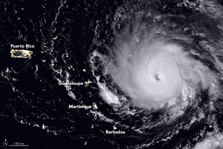
Category 5 Hurricane Irma 2nd strongest ever in Atlantic
Source of data: Irma track and forecast tracks: National Hurricane Center
5 September, 2017. "Throughout the day this Tuesday, Sept. 5, 2017, Category 5 Hurricane Irma has increased in power again and again, and as of 2 p.m. ET, contains sustained winds of 185 mph, tying with three others as the second most powerful* Atlantic hurricane on record
The immediate threat is to the islands, and it will be a massive one to the British Virgin Islands, Anguilla and Antigua and Barbuda. We have details in our story.
Believe it or not, there's not much of a precedent for a storm this strong on the Caribbean islands. Only one Category 5 (David, 1979, much further away and to the south of Puerto Rico), and only eight Category 4 hurricanes have passed through this area since 1950. This is the most impressive hurricane I've ever seen on the Caribbean Radar.
<...> *Irma's pressure doesn't rank in the top 10, however, standing at 926 mb as of 2 p.m.; the strongest hurricane in the Atlantic as measured by pressure was Hurricane Wilma in 2005, at 882 mb, something I was lucky to blog about on AccuWeather.com."
Cat 5 Hurricane Irma 2nd strongest ever in Atlantic. (n.d.). Retrieved September 05, 2017, from https://www.accuweather.com/en/weather-blogs/weathermatrix/cat-5-hu...
5 September, 2017. Source: NASA Earth observatory Link
Reference: Hurricane Irma Strengthens : Natural Hazards. (n.d.). Retrieved September 05, 2017, from https://earthobservatory.nasa.gov/NaturalHazards/view.php?id=90901
"Hurricane Irma intensified into an extremely dangerous high-end Category 5 storm with top sustained winds of 180 mph on Tuesday morning, putting it among the strongest Atlantic hurricanes ever observed. Irma's winds are the most powerful ever measured in an Atlantic hurricane north of the Caribbean and east of the Gulf of Mexico. Measurements from Hurricane Hunter aircraft found peak winds of close to 180 mph, well above the 157-mph threshold for Category 5 strength. At 11:07 am EDT, a dropsonde in Irma's eye measured a central pressure of 927 millibars, 4 mb lower than the previous pass, so Irma is still strengthening."
Reference: Category 5 Irma the 5th Strongest Atlantic Hurricane on Record. (n.d.). Retrieved September 05, 2017, from https://www.wunderground.com/cat6/category-5-irma-5th-strongest-atl...
-
-
Hurricane Irma strongest since 2007 in Atlantic basin. Hurricane Irma now a 5 Category storm
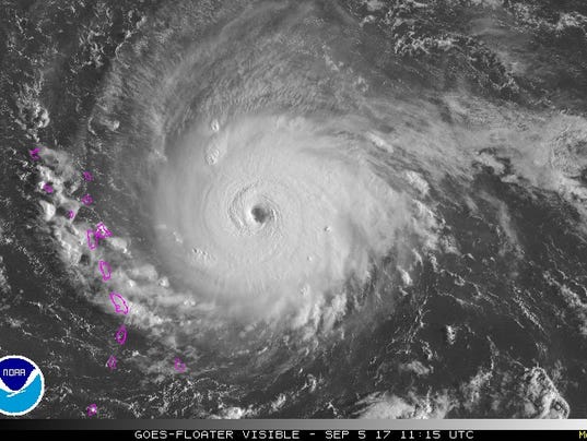
Source of image: https://www.usatoday.com/story/weather/2017/09/05/hurricane-irma-no...
5 September, 2017 "Wednesday the storm is expected to be near Puerto Rico and by Friday it will be near Cuba. Meteorologists warned that Hurricane Irma is a big storm and the strongest in the Atlantic since 2007's Hurricane Felix. In the Jacksonville area, there will be an increasing threat of dangerous rip currents for several days. Because of the weather threat, the opening of the new flyover J.T. Butler and I-95 has been delayed indefinitely.
Many hazards include: Elevated surf, coastal flooding, and beach erosion toward the end of the week. There is also a threat of very heavy rainfall through Northeast Florida this weekend. (7-day forecast) The storm is then expected to make a quick turn to the north early Sunday morning, but it is still unknown at this time what that track will look like."
Reference: Action News Jax (2017, September 05). Hurricane Irma: Category 5 storm; Scott declares State of Emergency. Retrieved September 05, 2017, from http://www.actionnewsjax.com/news/local/hurricane-irma-category-5-s...
-
-
http://www.ksdk.com/news/firestorm-burning-more-than-half-a-million...
'Firestorm' burning more than half a million acres in Montana

SEARCH PS Ning or Zetatalk
Nancy Lieder, Emissary of the Zetas.
https://poleshift.ning.com/xn/detail/3863141:Comment:1168188
Awakening to the Alien Presence ZetaTalk
The truth will likely never to be known to the public but be washed away in the Nibiru panic soon to engulf the world.
The Worst of the Cover-Up
https://poleshift.ning.com/profiles/blogs/the-worst-of-the-cover-up
Main Establishment Lies
https://poleshift.ning.com/profiles/blogs/main-establishment-lies
Donate
© 2025 Created by 0nin2migqvl32.
Powered by
![]()
You need to be a member of Earth Changes and the Pole Shift to add comments!
Join Earth Changes and the Pole Shift