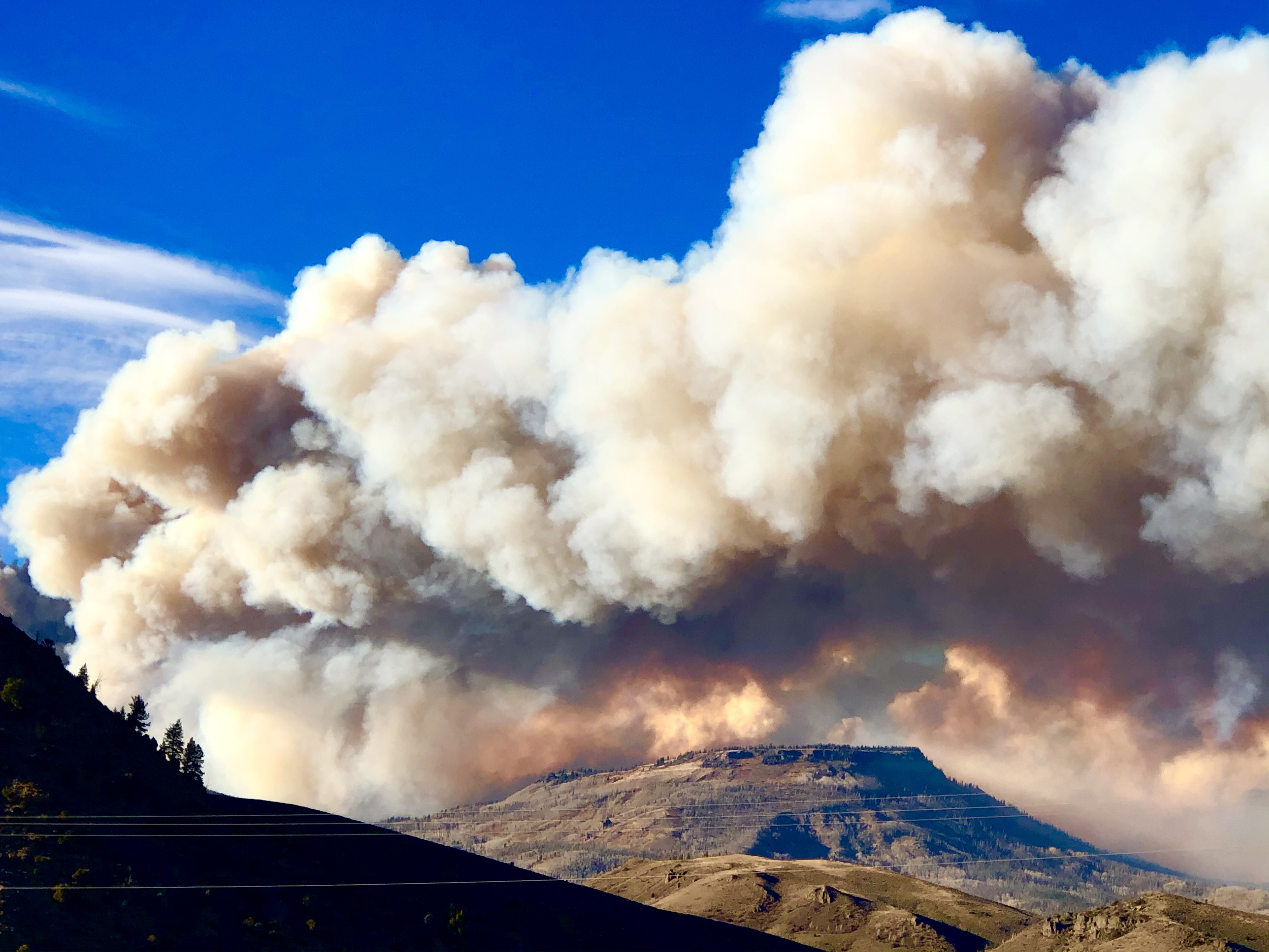
Giant waves crash over seawalls during a storm

in the suburbs of Taipei, Taiwan. 21.10.2025

"We warned at the start of ZetaTalk, in 1995, that unpredictable weather extremes, switching about from drought to deluge, would occur and increase on a lineal basis up until the pole shift. Where this occurred steadily, it has only recently become undeniable. ZetaTalk, and only ZetaTalk, warned of these weather changes, at that early date. Our early warnings spoke to the issue of global heating from the core outward, hardly Global Warming, a surface or atmospheric issue, but caused by consternation in the core. Affected by the approach of Planet X, which was by then starting to zoom rapidly toward the inner solar system for its periodic passage, the core was churning, melting the permafrost and glaciers and riling up volcanoes. When the passage did not occur as expected in 2003 because Planet X had stalled in the inner solar system, we explained the increasing weather irregularities in the context of the global wobble that had ensued - weather wobbles where the Earth is suddenly forced under air masses, churning them. This evolved by 2005 into a looping jet stream, loops breaking away and turning like a tornado to affect the air masses underneath. Meanwhile, on Planet Earth, droughts had become more intractable and deluges positively frightening, temperature swings bringing snow in summer in the tropics and searing heat in Arctic regions, with the violence of storms increasing in number and ferocity."

ZETATALK

Wild Weather, the Wobble Effect - Earth Changes and the Pole Shift

Views: 637167

Comment

You need to be a member of Earth Changes and the Pole Shift to add comments!

Join Earth Changes and the Pole Shift

Comment by Juan F Martinez on July 10, 2020 at 6:28pm
Comment by KM on July 10, 2020 at 6:23am

Source

Unprecedented Floods in Japan Kill at Least 60 People – More Than 550,000 Told to Evacuate After 4 Inches of Rain Fall in an Hour

Torrential rain storms that triggered flash floods and mudslides in Japan’s Kyushu region have left 60 people dead or missing.

Hundreds of thousands have also been evacuated to safer areas.

japan floods july 2020, japan rains, japan weather anomaly, japan rain apocalypse, Flooding and landslides caused by unprecedented rain in southern Japan have left at least 60 people dead
Flooding and landslides caused by unprecedented rain in southern Japan have left at least 60 people dead. Picture via Youtube video

Mother Nature’s wrath continues to sweep Japan.

Torrential rain in the country’s Kyushu region, southwestern Japan, has triggered floods and mudslides.

Authorities say at least 49 people have been confirmed dead, while eleven others are unaccounted for.

Unprecedented Rain

Japan’s Meteorological Agency said such rainfall had never been seen before in the region. As much as 4 inches an hour fell at one time.

The heavy rainfall on Friday and Saturday in Kumamoto totaled nearly 20 inches in Minamata and nearly 16 inches in Kuma, Yunomae and Amakusa, according to the Meteorological Agency.

Rescue efforts have been hampered by continued downpours, with up to 300 millimeters of rain in the forecast through Tuesday.

Evacuations

Meteorological authorities in Japan have also issued special heavy rain warnings to three prefectures Nagasaki, Saga, and Fukuoka and the authorities have also issued evacuation orders to 330,000 citizens.

Such orders have also been issued to 205,000 people in Kumamoto Prefecture, and to approximately 35,000 in Miyazaki and Kagoshima Prefecture, totaling 550,000 people across Japan.

Rescue

With many waiting to be rescued, the Japanese government has also dispatched around 10,000 Ground Self-Defense Force personnel to the hardest-hit areas.

More than 2,000 households have been left stranded, many of which are home to elderly people.

Helicopters and boats have been rescuing people from their homes where they can.

The flooding has also cut off power and communication lines, further delaying search and rescue efforts.

https://strangesounds.org/2020/07/japan-floods-60-dead-videos-evacu...

Comment by KM on July 8, 2020 at 10:34pm

Source

Fast-Moving Line of Severe Storms Triggers Tsunami in Upper Chesapeake Bay

A rare meteotsunami formed in the Chesapeake Bay as thunderstorms rolled through Maryland Monday night.

According the The National Weather Service’s Mt. Holly bureau the tsunami formed near Tolchester Beach in Kent County.

meteotsunami Chesapeake Bay, meteotsunami Chesapeake Bay video, meteotsunami Chesapeake Bay pictures, meteotsunami Chesapeake Bay july 2020
Extreme storms create meteotsunami on Chesapeake Bay on July 6, 2020. Picture: NOAA/Michelle Mcgahey

A meteotsunami is a tsunami wave that is brought on by air-pressure disturbances often associated with fast-moving weather events like severe thunderstorms, squalls, and other storm fronts.

The tidal chart showed that there was a sharp rise and fall along several smaller waves. This wasn’t due to any seismic activity, instead it was due to the substantial pressure created by the thunderstorm.

This is the classic meteotsunami signature with a tsunami wave followed by several smaller waves in response.

Powerful storm

According to folks at Tolchester Marina, the storm was extremely intense. Cathy Bramble, marina president, tells Bay Bulletin the rain came down sideways and wind gusts were so strong that Tolchester’s 20-foot steel flagpole was bent. Bramble says the wind also blew a sign right into the marina’s palm tree, where it became lodged in the trunk.

Boaters at the marina saw hail and one sailboater’s wind instrument clocked a gust at just under 70 miles per hour.

Radar loops showed that the storm outflow – a line, or in this case a ring, of cool dry winds – move out of the thunderstorm cluster in a symmetric pattern. “This pattern would have produced gusty winds as it passed over the Cheapeake Bay and lowered the atmospheric pressure suddenly,” explains Snider.

Two years ago, in May 2018, two meteotsunamis formed on Lake Michigan within a single day! Amazing!


The last suspected meteotsunami on the mid-Atlantic coast was the result of a derecho back in 2013. The rare phenomenon is hard to predict and there is no warning system yet.

https://strangesounds.org/2020/07/tsunami-chesapeake-bay-usa-meteot...

Comment by KM on July 7, 2020 at 6:57am

https://watchers.news/2020/07/06/saskatchewan-hit-by-3-tornadoes-in...

Saskatchewan hit by 3 tornadoes, intense rain and large hail, Canada


Saskatchewan hit by 3 tornadoes, intense rain and large hail, Canada


At least three tornadoes touched down in southwest Saskatchewan Saturday afternoon, July 4, 2020. The storm also brought damaging winds, large hail, and intense rainfall to the province. Environment Canada confirmed the first twister near Glenbain, the second near Kincaid to Woodrow, and the third near Assiniboia. Some of the reported damage is still being investigated.

Environment Canada issued its first tornado warning around 21:40 UTC (15:40 LT) on Saturday. A storm system moved southeast across the province, hitting Kincaid and Glenbain an hour later.

The tornado was later confirmed, but no damage was reported by Sunday, July 5.

Hail also fell in some parts of the province, which was said to be around the size of a golfball. Many farmers said their crops were affected by the storm.

The second tornado hit Kincaid at roughly 22:40 UTC (16:40 LT), where damage to a home and farm is still being investigated, the department said.

Around 00:20 UTC on July 5 (18:20 LT on July 4), a third twister touched down near Assiniboia. No damage was reported.

In a weather summary issued on July 5, Environment Canada noted that "these storm assessments are considered preliminary and may be changed if more information becomes available."

Severe weather had been affecting Saskatchewan over the past days. During the first week of July, the northwestern region was hit by rare flooding, which was described as the worst in 46 years.

Meanwhile, the neighboring province of Manitoba was struck by a "once-in-1 000-year" flood event in the same period as the Rivers Dam hit its highest level on record. 

Comment by KM on July 3, 2020 at 10:37pm

https://watchers.news/2020/07/03/rivers-dam-hits-highest-level-caus...

Rivers Dam hits highest level, causing '1 000-year' flooding - Manitoba, Canada


Rivers Dam hits highest level, causing '1 000-year' flooding - Manitoba, Canada


Up to 38 homes and 83 people were evacuated in southern Manitoba on Wednesday night, July 1, 2020, as the Rivers Dam hit its highest level in a "once-in-1 000-year" event, said Infrastructure Minister Ron Schuler. The incident was unprecedented and unimaginable, according to Rural Municipality of Riverdale Mayor Todd Gill.

"I don't think anybody could have conceivably anticipated this much water coming at us, and it came at us at an incredibly fast rate," Schuler stated at a news conference Thursday afternoon, July 2.

"The government no longer has confidence in the structure in the dam at Rivers, Manitoba."

Engineers are on-site to monitor the spillway for any signs of trouble, he added. The province also deployed 11 standard emergency response trailers, including water pumps and water tubes.

The water flows from Lake Wahtopanah and the Little Saskatchewan River at the dam are more than 340 cubic m per second (12 000 cubic feet per second), which surpassed the 2011 flood levels.

"The water level at the Rivers Dam is at its highest level, ever," Schuler noted, calling it a "once-in-1 000-year" event.

Heavy downpours have caused water levels to rise in creeks and rivers in the area. The town of Neepawa has already declared a local state of emergency due to high water levels along the Whitemud River.

In areas near the Little Saskatchewan River Valley, Gill said 38 families had evacuated after days of intense rains in the southwest and western Manitoba.

Northwest Saskatchewan was hit by rare flooding this week, which was described as the worst in 46 years.

"It’s not only unprecedented but unimaginable, really," Gill said Thursday. "Never would anybody imagine what we are facing right now."

Hours after the evacuations, people downstream of the dam were keeping an eye on the structure to see if it will withstand the water accumulating over the past days, Gill added.

"People are literally right on site, 24 hours a day, monitoring and studying this structure because it's got a wall of water behind it that nobody has ever seen before," the mayor said.

Some areas have received record-high rainfall of more than 200 mm (8 inches) this week. 

Comment by KM on July 1, 2020 at 5:29pm

https://watchers.news/2020/07/01/northwest-saskatchewan-hit-by-wors...

Northwest Saskatchewan hit by worst flooding in 46 years, Canada


Northwest Saskatchewan hit by worst flooding in 46 years, Canada


Rare flooding, described as the worst in 46 years, hit the northwest Saskatchewan this week. High flow is making its way to the Beaver River, affecting the Beauval area.

Overland flooding on the Little Saskatchewan River through Rapid City has affected multiple properties, and road washouts were reported both local and provincial.

"Our road is underwater and breaking up," said Candyce Paul, the incident commander with English River First Antion's emergency management team.

The last time flooding was this bad was in 1974, Paul said, adding that it is possible that some roads may be closed. Saskatchewan Highways also said that floodwaters may force the closure of Highway 165 in the province's north.

"This is something we've been asking the government, 'Are you going to keep this road open? Do you have a plan B'?" she stated.

"By the sounds of it, plan B is we're cut off for three weeks, likely."

Paula noted that this is a big concern, especially amid the coronavirus pandemic where there are limited services in the province's north. Five communities depend on the road to get essentials, she added. 

"We don't even have a store here, or at La Plonge, where we can get essentials. We can't get gas here. Our medical services and our mail, all on the other side. The pharmacy's on the other side."

According to the province's Water Safety Agency, water levels are still rising and it could hit its peak in a few days.

"After the peak hits, it's a gradual decrease," said Patrick Boyle with Water Safety Agency. "You'll have high water levels there for probably the next week to 10 days for sure, and then they gradually start to go down."

The flooding was caused by heavy rains in Alberta and northwest Saskatchewan, Boyle added.

Paul also noted that her community may leave a truck on the other side of the water and escort citizens who need to travel to get there.

The ministry, on the other hand, assured that it is monitoring the water levels, has set up barriers, and has put an 8 000 kg (17 600 lbs) weight limit in place.

Comment by Gerard Zwaan on June 30, 2020 at 11:58pm

US Weather Anomalies: State of Emergency Declared After 9 Inches of Rain in 24 Hours Trigger​​__ Deadly Flash Floods in Western Wisconsin – 6 Inches of Snow in Idaho

wisconsin floods, wisconsin flashfloods Deadly flash floods in Wisconsin on June 29, 2020. Picture via Facebook

Officials in St. Croix County in western Wisconsin declared a state of emergency on 29 June after major flash flooding.

In a statement, county officials said: On June 28 and 29, parts of St. Croix County received over seven inches of rain causing flooding and washed out roads across the county.

The areas experiencing significant flooding are the Municipalities of Kinnickinnic, Pleasant Valley, Rush River, Eau Galle, Warren, Hammond, Baldwin, Springfield, Erin Prairie, Emerald, Glenwood, Cylon, and Forest.

According to NWS Twin Cities, in a 24 hour period to 29 June, Emerald recorded 9.13 inches (232 mm) of rain, Baldwin 8.22 inches (208.79 mm), Hammond 8.20 inches (208.28 mm) and River Fall 7.25 inches (184.15 mm).

At one point over 50 roads were closed in the area due to flooding.

St. Croix County Sheriff’s Office reported that a man died after after his vehicle entered a flooded area in the town of Baldwin. The vehicle entered a ditch and became submerged in water.

The Sheriff’s Office also said that at least eight families were evacuated from houses near an overflowing creek and taken to a nearby community centre. – Floodlist

Meanwhile, portions of the Wood River Valley in Idaho woke up to more than 6 inches of snow on Monday morning, as the end of June looked more like a mid-winter morning.

snow idaho june 2020, snow idaho june 2020 video, snow idaho june 2020 picture
Galena Summit saw more than 6 inches of snow on Monday, an uncommon occurrence at the end of June in Idaho. Picture: Eric Brill / KMVT

The mountain towns within the Central and Sawtooth Mountains were a little bit too warm too see any of the white stuff fly, but once you were able to get above approximately 6,700 feet, snow started to cover the ground.

At Galena Summit, which is approximately midway between Ketchum and Stanley, saw more than 6 inches of snow. This is at approximately 8,700 feet above sea level, and of course, the higher you are above sea level within this part of the Central and Sawtooth Mountains, the more snow you will see.

Luckily, with temperatures last week as well as Saturday in the 70s for highs, the snow wasn’t able to accumulate very much on Highway 75.

With that noted, the threat of snow is expected to linger around until Tuesday. Another 2-4 inches of snow will be possible, with the majority of the accumulation happening on grassy surfaces, as well as the majestic trees of the Sawtooth National Forest.

While the snow isn’t the most common thing to see in southern Idaho for late June, the amount of snow that is accumulating within this specific storm is uncommon.  KMTV


Source:https://strangesounds.org/2020/06/weather-anomalies-wisconsin-flash...

Comment by Juan F Martinez on June 25, 2020 at 1:24am

Videos show massive flooding in S. China, Three Gorges Dam next
Three Gorges Dam faces serious test as Chongqing hit by worst flooding in 80 years

TAIPEI (Taiwan News) — As southern China sees some of its worst flooding in 80 years, videos have surfaced showing extreme quantities of water inundating 10 provinces and cities, threatening the vaunted Three Gorges Dam.

As China's Yangtze River Basin enters its flood season, the upper reaches of the Three Gorges Dam are seeing the highest flood levels since 1940. Weather China has issued its highest warning for flooding and rain for the middle and lower reaches of the Yangtze River to Guizhou.
The rainfall is expected to peak on Tuesday and Wednesday (June 23 and 24). Flood warnings have been issued in more than 10 provinces and municipalities in China, including Guizhou, Chongqing, Hunan, Hubei, Jiangxi, Anhui, Jiangsu, Zhejiang, Shanghai, and Guangxi.

https://www.taiwannews.com.tw/en/news/3952434

Comment by KM on June 16, 2020 at 6:02am

https://saskatoon.ctvnews.ca/rural-sask-wind-storm-wreaks-havoc-lea...

Rural Sask. wind storm wreaks havoc, leaves behind overturned grain cars

CTV News Prince Albert’s Lisa Risom on how the aftermath of a hail has prompted the RM of Birch Hills to declare a state of emergency.

BIRCH HILLS -- The aftermath left by a wind and hail storm over the weekend has prompted the RM of Birch Hills to declare a state of emergency.

On Sunday evening, high winds and hail damaged the roofs of buildings, broke trees and overturned grain bins. About 20 grain cars were blown off the train tracks in the RM.

“It was a plow wind,” said Brancepeth resident Dwade Segi. He’s lived in the hamlet, located in the RM, for 16-years. 

The roof of the community's water treatment plant was destroyed by the wind.

RM of Birch Hills wind storm

“I worked until midnight last night trying to get the water treatment plant taken care of. We had to get generators out of Prince Albert.”

SaskPower said 15 power lines were broken in the storm and they are working to restore power in Brancepeth area.

The Reeve of the RM Allan Evans said the state of emergency will help the community access equipment or supplies from the province such as generators. 

The RM is also looking at accessing the Provincial Disaster Assistance Program to help with the cleanup, Evans said.

Brancepath train cars

Flooding, high winds reported after massive storm pummels north-east Sask.

Humboldt declared state of emergency, train blown off tracks near Birch Hills

A train was blown off its tracks and a shed was tipped over after a serious storm near the Brancepeth area Sunday afternoon. (Larry Markowsky/Submitted)

People in an area between Humboldt and Birch Hills are picking up the pieces after a wicked storm blew through the area Sunday afternoon.

Comment by Juan F Martinez on June 15, 2020 at 5:16am

"I’m a sucker for a great weather photo - this one may be one of the best!"

~ Chris Nelson KIMT Chief Meteorologist,  2 hours ago

Taken near a supercell thunderstorm, Stavros K in Springlake, TX caught this one via camera.

https://www.facebook.com/chrisnelsonKIMTchief/photos/a.162152430473...

SEARCH PS Ning or Zetatalk

 
Search:

This free script provided by
JavaScript Kit

Donate

Donate to support Pole Shift ning costs. Thank you!

© 2025   Created by 0nin2migqvl32.   Powered by

Badges  |  Report an Issue  |  Terms of Service