Wild Weather, the Wobble Effect
TOTAL DESTRUCTION IN PARTS OF CEBU CITY, PHILIPPINES, 05.11.25
Massive flooding in Da Nang, Vietnam. 30.10.2025.
Giant waves crash over seawalls during a storm
in the suburbs of Taipei, Taiwan. 21.10.2025
"We warned at the start of ZetaTalk, in 1995, that unpredictable weather extremes, switching about from drought to deluge, would occur and increase on a lineal basis up until the pole shift. Where this occurred steadily, it has only recently become undeniable. ZetaTalk, and only ZetaTalk, warned of these weather changes, at that early date. Our early warnings spoke to the issue of global heating from the core outward, hardly Global Warming, a surface or atmospheric issue, but caused by consternation in the core. Affected by the approach of Planet X, which was by then starting to zoom rapidly toward the inner solar system for its periodic passage, the core was churning, melting the permafrost and glaciers and riling up volcanoes. When the passage did not occur as expected in 2003 because Planet X had stalled in the inner solar system, we explained the increasing weather irregularities in the context of the global wobble that had ensued - weather wobbles where the Earth is suddenly forced under air masses, churning them. This evolved by 2005 into a looping jet stream, loops breaking away and turning like a tornado to affect the air masses underneath. Meanwhile, on Planet Earth, droughts had become more intractable and deluges positively frightening, temperature swings bringing snow in summer in the tropics and searing heat in Arctic regions, with the violence of storms increasing in number and ferocity."
ZETATALK
Wild Weather, the Wobble Effect - Earth Changes and the Pole Shift
Views: 641616
Comment
-
Comment by Sevan Makaracı on April 27, 2014 at 9:06pm
-
Heatwave higher than usual for this time of year making life miserable accross Bangladesh
A heatwave that has been blazing across Bangladesh, making life miserable all around, will continue at least for two more days, the Met office says.
On Sunday, the mercury shot to 40 degrees Celsius in Rangamati, the highest temperature of the season - six notches higher than the normal reading of 34 degrees for this time of the year.
Capital Dhaka recorded a temperature of 38.5 degrees in the day.
The weather office declares heatwave conditions when the maximum temperature rises five degrees above normal to either touch or cross 40.
Senior Met officer Sanaul Haq Mandal said the high levels of humidity made the heat unbearable. On Sunday, Dhaka recorded 77 percent humidity. .....
-
Comment by lonne rey on April 27, 2014 at 10:52am
-
Winter comes again suddenly for Russia’s Urals
Russia’s Urals region has been hit with freak winter weather, with severe snowstorms causing massive traffic jams, flight delays, power blackouts and school closures.
Just when everybody in the cities of Ekaterinburg and Chelyabinsk thought they had waved winter good-bye and was anticipating greener spring weather, blizzards dragging the region back to winter.
Winter struck the region hard, with precipitation twice the monthly average coming as a shock to already burgeoning grass and trees.
Urals meteorologists have said the last time the region was struck by a snowfall of such severity in springtime was 123 years ago. They’ve found an April 26, 1891 issue of “Ekaterinburg Week” magazine that reported how the region witnessed “even more snow fallen than throughout the whole winter”.
-
-
Just days before Easter, in Romania it snowed like it was Christmas. Snow cover 10 cm in Predeal

Just days before Easter , on April 14, it snowed like at Christmas. – road workers were out working just like in a regular month of winter !Romania was under code yellow alert for snow and rain in 12 districts in the country !
Everyone hoped the snow would pass quickly, but on Friday it began snowing again, dumping 10 cm of snow on Predeal .
Tourist : “I got winter in the mountains, we came to leave for the summer so I am not prepared for winter, I had to change the tires.
Tourist: "I've got two days of rain and sunny spring and summer and then two days yesterday and today two authentic winter days.
Worried for trees already in bloom and cultures that have sprung up in the garden
In Step Tihuta , which links Transylvania and Moldavia , snow removal machinery worked almost as hard as in full winter . Snow measured 10 inches , and the wind blew hard. Temperatures dropped to 0 degrees on Friday, and people made fires in their stoves . I am worried for the animals, but also for trees already in bloom and cultures that have sprung up in the garden.
The landscape looked like the middle of December.
http://translate.google.com/translate?hl=en&sl=auto&tl=en&a...
-
Comment by Kojima on April 26, 2014 at 4:21am
-
Flash floods kill more than 100 in north Afghanistan [Relief Web: 25 April, 2014]
Afghanistan Flash Floods Situation Report No. 1 as of 2300h (local time) on 25 April 2014
Situation Overview
Heavy rainfall, which started on 24 April, has sparked flash floods in 23 districts, across six provinces, of the Northern Region of Afghanistan. Provincial authorities report that 123 people have been killed and more are still missing.
As assessments are underway to determine the full extent of the damage caused, as well as the humanitarian needs of the affected population, it is still too early to get a full picture of the scale of the flooding. Initial reports indicate that Jawzjan province is the worst affected in the region, where 80 people have reportedly been killed and some 6,000 people have been displaced. The provinces of Faryab, Sar-e-Pul, Balkh, Samangan and Takhar have also been affected to a lesser degree.
The Afghan Government’s Provincial Disaster Management Committees (PDMC) are leading the coordination of the response within their affected provinces, with support from humanitarian agencies. Limited access to some of the more heavily affected areas remains a key challenge.
Priority needs at present include clean drinking water, medical supplies, food, non-food items and shelter.
-
-
China’s Great Wall of Dust [Earth Observatory: 23 April, 2014]
A wall of dust was barreling across northern China on April 23, 2014, when the Moderate Resolution Imaging Spectroradiometer (MODIS) acquired these images from NASA’s Aqua and Terra satellites. The top image was taken at 12:35 p.m. local time, and the lower image is from 2:20 p.m. Turn on the image comparison tool to see how far the dust advanced in the two hours between images.
Dust storms are common in the deserts of northern China, but they peak during the spring when large storms and weather fronts move in from Siberia. In this case, a very large front appears to be pushing east across Asia, kicking up dust ahead of it. On the ground, the dust brought visibility down to less than 50 meters (160 feet), veiling parts of northwest China in yellow haze.
The winds and resulting dust are widespread, since a dense airborne dust plume is visible under the clouds throughout the scene. The large storm also extended to the Taklimakan Desert (immediately southwest of the area shown here) on April 23 and April 24.
See also;
"Day or night? Massive sandstorm plunges China into red mist" of lonne's comment in Red Dust effects
-
-
Two articles about the strong wind
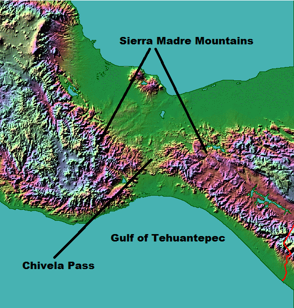
1) Tehuano Winds [Earth Observatory; 8 April, 2014]
Cool air often follows storm systems passing through North America in the winter and early spring. In some cases, the cool air surges as far south as Mexico, where it encounters the Sierra Madre Oriental Mountains, a long chain oriented roughly parallel to Mexico’s Atlantic coast. The mountains behave like a wall, funneling winds to the south until they reach Chivela Pass, a gap in the range on the Isthmus of Tehuantepec.
At the gap, pressure differences between cool, dry air from the north and warm, moist air from the south cause winds to rush toward the Pacific Ocean. Northerlies that last for more than a day are known as Tehuano winds. Such winds can be extremely strong, reaching gale or even hurricane force on the Beaufort wind scale.
The Moderate Resolution Imaging Spectroradiometer (MODIS) on the Aqua satellite captured this image on April 8, 2014, when Tehuano winds carried dust over the Gulf of Tehuantepec. A thin arc cloud marked the leading edge of this pulse of wind.
Read this blog post from the Cooperative Institute for Meteorological Satellite Studies (CMISS) to learn more about the event and to see a sequence of images showing the wind front fanning outward over time.
-- [Tehuano: http://glossary.ametsoc.org/wiki/Tehuano]--
A Spanish term frequently used to denote a burst of strong offshore (southward) wind, lasting a day or more, that blows from the Gulf of Mexico across the Gulf of Tehuantepec.
Tehuano events are associated with winter surges of cold air that spread southward from the United States across the Gulf of Mexico behind strong weather fronts. Tehuanos produce much local cooling of the gulf waters and frequently cause anticyclonic warm-core ocean eddies to form and propagate west-southwestward near 12°–14°N.
2) Wildfire Burns Valparaiso, Chile [Earth Observatory; 13 April, 2014]
High winds propelled a wildfire through parts of Valparaiso, Chile, on April 13, 2014. It quickly became the largest fire in the history of this port city. The fire started in a forested area on April 12 and eventually reached wooden homes built on steep hills around the city. According to news reports, at least 12 people died, 2,000 homes were destroyed, and about 10,000 people evacuated as the fire moved through a section of the historic city.
The Moderate Resolution Imaging Spectroradiometer (MODIS) on NASA’s Terra satellite acquired this image of the fire at 11:10 am local time (14:10 UTC) on April 13. Fire detections are outlined in red in the forest south of the city, which is pale gray. A long plume of smoke stretches northwest over the Pacific Ocean, a clear indication that winds were strong and blowing the flames toward the city.
Valparaiso is the third largest city in Chile, with a population of more than 280,000 people. It was established in 1536 and developed into an important international seaport in the 19th century. The city is a UNESCO World Heritage site.
-- largest fire in the history of this port city --
http://www.mercuriovalpo.cl/impresa/2014/04/14/full/2/
-- NPR News (2014, April 14) For second night, Valparaiso fire spreads misery in Chile --
-
Comment by Howard on April 11, 2014 at 4:27pm
-
Bizarre Cloud Engulfs Spanish Coastline (Apr 9)
A mysterious dense cloud has appeared over the entire coastline of Alicante in Spain.
The Hotel Castilla Alicante confirmed that locals have no idea what has caused the cloud saying, "dense cloud took over the entire coastline of the city of Alicante, causing some confusion among residents and tourists".
Source
http://www.mirror.co.uk/news/weird-news/alicante-apocalyptic-cloud-...
http://www.dailymail.co.uk/travel/article-2600562/Video-showing-hug...
-
Comment by Yvonne Lawson on April 6, 2014 at 12:39pm
-
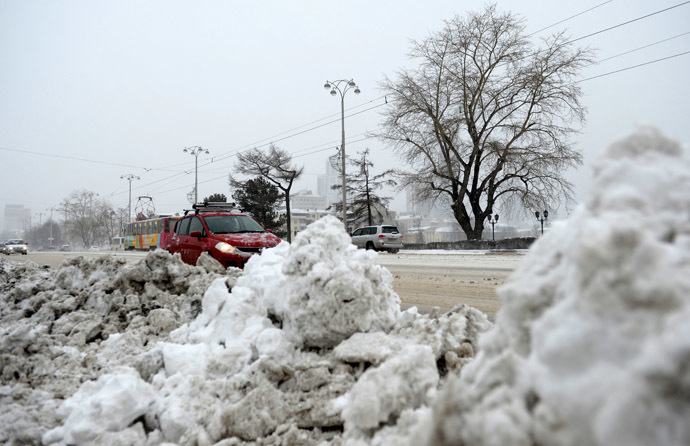
April snow in Moscow: weather continues to surprise
Photo: RIA Novosti
The weather does not cease to surprise: the European part of Russia is still taking actions to recover from the consequences of an unprecedented April snowfall; the Far East began fighting against forest fires; and Siberia is preparing for the opening of its great rivers. What weather surprises are in store for us this spring? Meteorologists told the Voice of Russia about anomalies and forecasts.
An abnormally warm February and March in the European part of Russia was replaced by April snowstorms. The heaviest snowfall in the past 130 years, which occurred in Moscow on the first day of April, turned the already spring town into a Blizzard Kingdom in just a few hours. Internet users immediately called this unusual phenomenon the main April Fool’s joke.
The unusually warm weather has set in Siberia. The air warmed up to +22 degrees. The abnormal April temperature has already caused forest fires. Dozens of hectares of taiga forest in the South of Siberia and the Far East are already enveloped in fire, chief of the Roshydromet Situation Centre, Yuri Varakin told the Voice of Russia.
"As for forest fires, the season has already started almost a month earlier, if compared to the last year and the year before last. This especially concerns the Far East and Primorsky Krai. And an immediate forecast for April says that we have increased fire hazard in the Trans-Baikal and Baikal regions, because the abnormally warm weather has set there now, and the snow melts quickly."
The early spring has also caused early floating of ice on Russian rivers. According to meteorologists, the situation is quite favourable: the winter was dry, and floods should not be expected. The majority of rivers in the European territory of Russia are at the floodplain level. All indicators suggest that there is no threat of flooding of settlements, leading specialist of the Phobos weather center, Elena Volosyuk says.
"In general, heavy rains are not expected this spring. It is obvious that in the European part of the country, floodings will be lower than in previous years, and than last year, when snowfalls were observed until the end of April and a number of regions of the European part of Russia led the pack in terms of snow storage. This year, the situation is quite different. But in Siberia, floodings, I think, will be at the level typical for this region. Opening of rivers has already begun. Ice blasting aimed at improving the ice cover situation is in progress on some rivers. So, in terms of flood, there should be no incidents."
Experts are closely monitoring the flood situation in the Far East, which suffered from the worst flood in the last 100 years last summer. Opening of ice on the Amur has already started, and it is almost a week ahead of schedule. The water level is expected to be up to the normal level. However, experts encourage local authorities to be ready for any developments of emergency situations, because the weather has repeatedly proven its unpredictability.
Read more: http://voiceofrussia.com/2014_04_05/April-snow-in-Moscow-weather-co...
-
-
Coldest December-March Period in Chicago History
THE IMPRESSIVE COLD THIS PAST WINTER CONTINUED DURING
MARCH...WITH A MONTHLY AVERAGE TEMPERATURE OF ONLY 31.7 DEGREES
FOR THE MONTH. THIS RANKS AS THE 19TH COLDEST MARCH ON RECORD IN
CHICAGO. HOWEVER...OF EVEN MORE INTEREST IS THE FACT THAT WITH THE
ABNORMALLY COLD MARCH ACROSS THE AREA...THIS MADE THE AVERAGE
TEMPERATURE FOR THE DECEMBER THROUGH MARCH PERIOD IN CHICAGO 22.0
DEGREES...WHICH IS THE COLDEST SUCH PERIOD ON RECORD FOR CHICAGO
DATING BACK TO 1872!ROCKFORD:
THE DECEMBER THROUGH MARCH AVERAGE
TEMPERATURE FOR ROCKFORD WAS 18.4 DEGREES. THIS RANKS AS THE 2ND
COLDEST SUCH PERIOD ON RECORD IN ROCKFORD DATING BACK TO 1906!
-
Comment by Andrey Eroshin on March 21, 2014 at 10:51am
-
14.03.14. Freak of nature: Hail storm dumps 3ft of ice on East African nation of Eritrea
http://www.express.co.uk/news/weird/464881/Freak-of-nature-Hail-sto...
SEARCH PS Ning or Zetatalk
Nancy Lieder, Emissary of the Zetas.
https://poleshift.ning.com/xn/detail/3863141:Comment:1168188
Awakening to the Alien Presence ZetaTalk
The truth will likely never to be known to the public but be washed away in the Nibiru panic soon to engulf the world.
The Worst of the Cover-Up
https://poleshift.ning.com/profiles/blogs/the-worst-of-the-cover-up
Main Establishment Lies
https://poleshift.ning.com/profiles/blogs/main-establishment-lies
Donate
© 2026 Created by 0nin2migqvl32.
Powered by
![]()
You need to be a member of Earth Changes and the Pole Shift to add comments!
Join Earth Changes and the Pole Shift