Wild Weather, the Wobble Effect
TOTAL DESTRUCTION IN PARTS OF CEBU CITY, PHILIPPINES, 05.11.25
Massive flooding in Da Nang, Vietnam. 30.10.2025.
Giant waves crash over seawalls during a storm
in the suburbs of Taipei, Taiwan. 21.10.2025
"We warned at the start of ZetaTalk, in 1995, that unpredictable weather extremes, switching about from drought to deluge, would occur and increase on a lineal basis up until the pole shift. Where this occurred steadily, it has only recently become undeniable. ZetaTalk, and only ZetaTalk, warned of these weather changes, at that early date. Our early warnings spoke to the issue of global heating from the core outward, hardly Global Warming, a surface or atmospheric issue, but caused by consternation in the core. Affected by the approach of Planet X, which was by then starting to zoom rapidly toward the inner solar system for its periodic passage, the core was churning, melting the permafrost and glaciers and riling up volcanoes. When the passage did not occur as expected in 2003 because Planet X had stalled in the inner solar system, we explained the increasing weather irregularities in the context of the global wobble that had ensued - weather wobbles where the Earth is suddenly forced under air masses, churning them. This evolved by 2005 into a looping jet stream, loops breaking away and turning like a tornado to affect the air masses underneath. Meanwhile, on Planet Earth, droughts had become more intractable and deluges positively frightening, temperature swings bringing snow in summer in the tropics and searing heat in Arctic regions, with the violence of storms increasing in number and ferocity."
ZETATALK
Wild Weather, the Wobble Effect - Earth Changes and the Pole Shift
Views: 640214
Comment
-
Comment by Howard on July 20, 2014 at 10:54pm
-
Rare Tornado, Violent Storms Kill 2 in France, Hundreds Evacuated (Jul 20)
Violent storms wreaked havoc across France on Sunday leaving two people dead, including one person who was killed when a mini-tornado ripped through a campsite in the Ardeche department of south-central France.
The tornado hit a campsite in the town of Saint-Just-d’Ardeche, pulling down trees and destroying caravans and tents on Sunday afternoon.
A 42-year-old Frenchman died when a tree fell on him as the tornado hit. Five others were left injured although their conditions are not believed to be life-threatening.
Captain François Degrange, from the local police told AFP that trees had been brought down over a three to four kilometer radius.
“I have never seen that in my career before,” he said.
In a separate incident a woman was also killed by a falling tree at a campsite at Saint-Paulet-de-Caisson in the neighbouring Gard department.
According to Midi-Libre newspaper a baby was also injured as the storms hit and had to be rushed to hospital.
Hundreds of campers in the region have had to be evacuated.
Nine departments in eastern France remained on alert for storms on Sunday evening, while other areas of north eastern France were on alert for heavy rain and floods.
Source
http://www.thelocal.fr/20140720/storms-and-mini-tornados-leave-two-...
-
Comment by jorge namour on July 20, 2014 at 3:12pm
-
Bad weather, violent storms in France: Huge hail, and it's coming on Italy ... [PHOTOS]
Saturday, July 19, 2014
As widely expected, the weather in the afternoon today hath been dogged with particular violence of England and France, where even now you are experiencing severe thunderstorms. Particularly violent hailstorms in France, where the grains than 5-6cm in diameter in the inland areas of the country (see photo accompanying this article). They are the same storms that will come in the next few hours on the north of Italy, therefore utmost attention to possible extreme events tomorrow - Sunday 20 - to the north.
http://www.meteoweb.eu/2014/07/maltempo-violenti-temporali-in-franc...
https://translate.google.com/translate?sl=it&tl=en&js=y&...
----------------------------------------------------------------------
Iran will rewrite a new page in history climate: the smashed +53 ° C to Gotvand, set a new world in 2014 max
Saturday, July 19, 2014
The high temperatures reached in recent days southern Iran
As we had budgeted in recent days, the heat has really made "fierce" in various places and cities of the Middle East, where the thermometer has crossed the fateful threshold of +50 ° C in the shade, with several peaks up to +51 ° C +52 ° C reached in the south of Iran.
Right on Iranian territory were reached, in recent days, the highest temperatures recorded on the Asian continent since the beginning of 2013. Iran has managed to overcome even extreme temperatures over 50 ° C, usually between May and the first days of June, you can reach in southern Pakistan, in the region of Baluchistan. Among the higher temperatures, above all, the incredible stand +53.0 ° C Gotvand, which represent nothing less than the highest temperature reached and extreme outside of the note "Death Valley" (the famous depression in the heart of the California desert Eastern Europe), which is still the world record holder for heat, with its undefeated +53.9 ° C, the highest temperature ever reached the highest on Earth since the beginning of 2014.Ma is not over here. Because in addition to the new record hot world of 2014, with net Gotvand +53.0 ° C, always yesterday was touched upon the record of the higher minimum, with +40.6 ° C marked in Hoeyniyeh, which also touches the the average daily temperature higher than ever archived on Earth, with an average estimated at +45.5 ° C.
http://www.meteoweb.eu/2014/07/liran-riscrive-nuova-pagina-storia-c...
https://translate.google.com/translate?sl=it&tl=en&js=y&...
-----------------------------------------------------
Exceptional thermal contrasts in Kazakhstan, from 40 ° C in the south-west to +0 ° C in the north-east
Saturday, July 19, 2014,
These days, Kazakhstan, great giant of Central Asia, is a country literally split in two, in terms of weather / climate. In fact, while the western sector of Kazakhstan is under the effects of an intense heat wave of Mobile, to the east colder air that slips from central Siberia is causing a dramatic drop in temperatures, with values close to 0 ° C even. These days we find maximum temperatures up to +39 ° C +40 ° C in the south-west of Kazakhstan, while further east, in Balaskin in the north-east, this morning there was an unusually cold summer. These strong thermal contrasts should persist in the coming days, between the west and the east Asian country.
-
Comment by Gerard Zwaan on July 19, 2014 at 5:10pm
-
From twitter
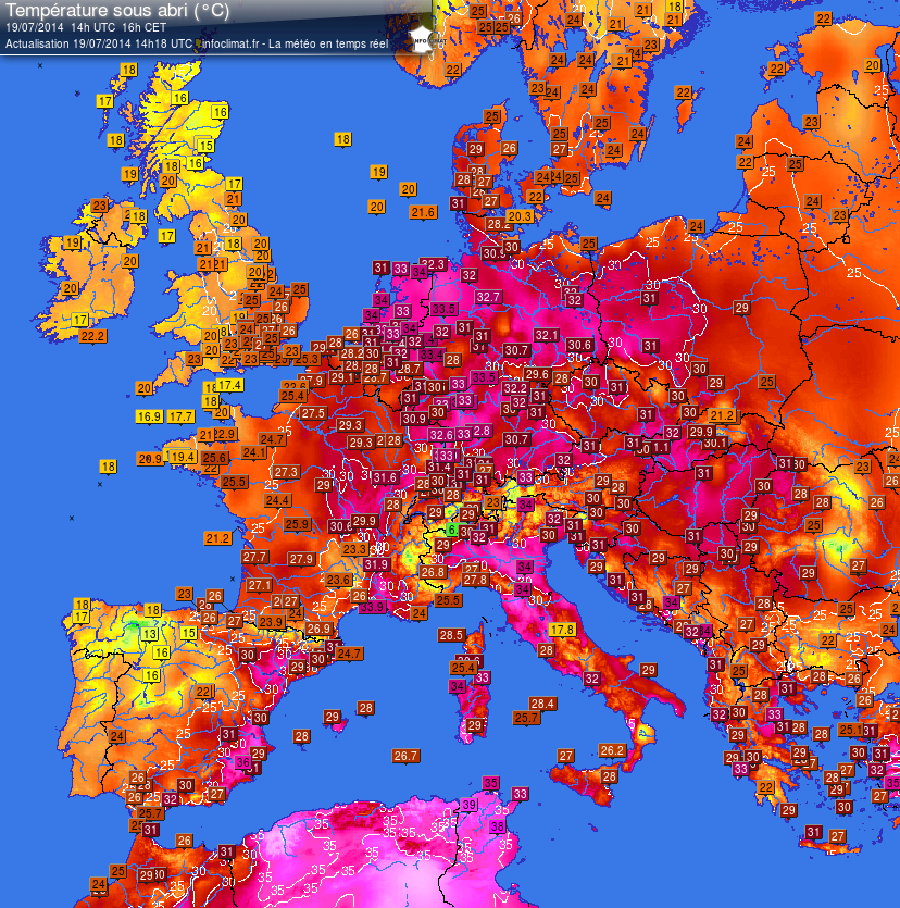
Unique! The netherlands is the warmest place in Europe pic.twitter.com/V6v8XGMbIc
source: https://twitter.com/weermanrobert/status/490503015313727488/photo/1
-
-
Polar Invasion Spawns Colorado Storms, Turning Lawns White With Hail (Jul 14)
It's not supposed to snow in the middle of July, is it?
While the storm that whitened lawns in parts of Colorado on Monday was the result of the polar air shoving its way south into a typically warm and moist July air mass, it wasn't a snowstorm.
Instead, it was hail that blanketed the ground in Berthoud, Colorado, on Monday. Several other Colorado communities also found themselves caked in accumulating hail as thunderstorms raked the state.
The thunderstorms formed along a front separating the unseasonably chilly polar air over the Upper Midwest from monsoonal moisture over the Southwest and the typical heat and humidity normally present over the South in mid-summer. Disturbances in the upper atmosphere and lift from winds blowing westward into the Rocky Mountains have further enhanced the thunderstorm activity over Colorado.
Berthoud is a city in Larimer and Weld counties of north-central Colorado. The two counties have had a combined 54 severe thunderstorm warnings issued by the National Weather Service so far in 2014, according to data compiled by Iowa State University. Of those 54 warnings, 53 have been issued since the beginning of May.
Source
http://www.weather.com/news/weather-severe/polar-invasion-colorado-...
-
-
Courtesy of Khan.
Burrard Inlet And English Bay Turn Blood Red (Jul 12)
Although highly irregular if not unprecedented, this phenomena is likely the result of unusually high waters temperatures in Burrard Inlet and English Bay and not red dust from the Planet X complex.
ZetaTalk Newsletter: September 25, 2010
"Per the Zetas, there will be no confusion, as when the red dust from the tail of Planet X starts to arrive in earnest, it will be during the last weeks and will be unmistakable."
ZetaTalk Prediction 1/15/1996: A second countdown sign is a fine red dust, unmistakable as it cannot be confused with any other natural occurrence. Ponds and rivers turn red, the blood color mentioned in the Bible's book of Revelations, with this iron ore dust giving the water a brackish taste. This countdown sign comes almost in step with the rapid slowing in rotation, This occurs a day or so before rotation stops.
Sources
http://bc.ctvnews.ca/heat-wave-hits-metro-vancouver-1.1910070
http://globalnews.ca/news/1444861/algae-bloom-turns-burrard-inlet-b...
http://www.huffingtonpost.ca/2014/07/11/red-algae-burrard-inlet-eng...
-
-
The great paradox of the summer 2014 while the Mediterranean and Italy came the cold air, extreme heat wave invests Norway
Friday, July 11, 2014
The configuration baric that these days dominates the scenery weather / climate on the old continent has features that have little to do with the summer season. Thus, while over central and west-central basin of the Mediterranean air masses circulate relatively cold extraction sub-polar sea, which are leading to a sharp drop in thermal values, especially between France and Italy, more north on Northland Norwegian inflow of very hot air from the sub-tropical latitudes of the Atlantic, is causing an exceptional heat wave, with the fall of dozens of record heat. It really seems a paradox to see temperatures of +34 ° C on the north of Norway, as in many Italian cities the thermometer struggles to exceed +22 ° C in the daytime. On all the while stand +34.0 ° C recorded in Møre og Romsdal. But the highest temperature ever touched on Norwegian territory are registered Hjeltnes +34.4 ° C, where the heat has become unbearable due to the high latitude. Remarkable well established +32.5 ° C in Narvik, where he seems to have been destroyed even the previous record of heat. This exceptional heat wave that is hitting hard the territories of north-central Norway is originated by the influx of air very warm and relatively humid, sub-tropical ocean to die, that the sub-tropical latitudes of the Atlantic, and more specifically from tract overlooking the Azores, back in the direction of the Norwegian Sea and Scandinavia, leading to a dramatic heated.
https://translate.google.com/translate?sl=it&tl=en&js=y&...
----------------------------------------------------------------------------
Impressive hailstorm devastated the Siberian city of Novosibirsk, causing deaths and injuries
Sunday, July 13, 2014,
Yesterday afternoon an impressive hailstorm, with large grains, as large as oranges, was struck at the gates of the city of Novosibirsk, the capital of the region of Novosibirsk in the Russian Federation and the Western Siberian Federal District, and the third largest city of Russia .
Already in recent days, with a specific article, we had talked about the intense heat wave that was taking place in several areas of central and western Siberia, where did you deal with daily temperatures well above the average for the period, with peaks reach the wall of the first +35 ° C +36 ° C in the shade, even approaching the threshold of +38 ° C +39 ° C in the south of Asiatic Russia.
The storm system, between 07:15 and 07:30 PM (local time), going back to nord-nord/est struck at Novosibirsk, bringing heavy rain and hail, with grains of medium and large size, which were preceded by the advent of strong and turbulent winds,
The super hailstorm has also taken aback dozens of swimmers who had decided to spend Saturday evening along the banks of the river Ob ', take the opportunity for a refreshing swim against the heat and the heat which has become oppressive.
The arrival of the storm and hail, with grains as large as oranges,
http://www.meteoweb.eu/2014/07/eccezionale-e-violenta-grandinata-a-...
VIDEO http://www.youtube.com/watch?v=cYBCVtfmKvQ#t=49
http://www.meteoweb.eu/2014/07/impressionante-grandinata-devasta-ci...
https://translate.google.com/translate?sl=it&tl=en&js=y&...
MAP; http://ds-lands.com/photo/cities/novosibirsk/03/
-
Comment by KM on July 13, 2014 at 4:56pm
-
http://voiceofrussia.com/news/2014_07_13/Snow-falls-in-South-Urals-...
Snow falls in South Urals in mid-summer
Heavy rain in the town of Zlatoust in Russia’s South Urals on Sunday, July 12, suddenly gave way to a blizzard in a rare twist of weather for the summer season.
"It wasn’t just rain and snow, but real snowfall with snowflakes as white as during winter. T melted quickly, of course. A fantastic sight," ITAR-TASS quotes an eyewitness, Valery Semyannikov, as saying.
In some areas of the Chelyabinsk region, snow lay 5-10 cm thick.
It’s the first ever mid-summer snowfall in the South Urals.
The Chelyabinsk weather service predicted "wet and windy weather with moderate to heavy rain throughout the region, thunderstorms and soft hail in the east and ice hail in the mountains."
-
Comment by lonne rey on July 13, 2014 at 1:03pm
-
Coldest Antarctic june ever redorded
07/09/2014
Original link in French
http://www.meteofrance.fr/web/comprendre-la-meteo/actualites?articl...
The austral winter is installed in the Antarctic. June there was even unusually cold. At the station Météo-France base Dumont d'Urville, there was an average temperature of -22.4 ° C, 6.6 ° C lower than normal *.
June 2014 is the month of June and the coldest since records began in 1956, and the second coldest month all together months (after September 1958 with -23.5 ° C). The daily minimum temperature record for June was also beaten with -34.9 ° C recorded 3 (previous record: -33.4 ° C).
Other elements make an unusual month in June 2014 in the Antarctic. Accustomed to strong winds even if the station is not located in a corridor of katabatic winds (see below), the wind there was particularly low: the average is less than 36% of normal (22.2 km / h against 35.3 km / h). June 2014 and is the second least windy month since the beginning of the measurements (21 km / h in 1978). Gusts have exceeded 120 km / h on only one occasion (127 km / h 17) against 6 usually. The 100 km / h was reached on 5 occasions, against just over 11 times usually.
-
-
Alps get summer snow as wet weather to stay
http://www.thelocal.fr/20140710/in-pictures-french-alps-get-summer-...
Holidaymakers in the Alps in recent days would have been forgiven for thinking they had come in the wrong season after the region was hit by some very unseasonal snowfalls. There was bad news for sunseekers too with the sun set to stay away for much of July.

-
-
http://www.couriermail.com.au/news/queensland/brisbane-hits-coldest...
If you are lucky enough to be reading this from the comfort of your blankets, it might be best to stay there, as Brisbane has hit its coldest temperatures in 103 years.
Not since July 28 1911 has Brisbane felt this cold, getting down to a brisk 2.6C at 6.41am.
At 7am, it inched up to 3.3C.
Matt Bass, meteorologist from BOM, said the region was well below our average temperatures.
“If it felt cold, that’s because it was, breaking that record is pretty phenomenal for Brisbane,” Bass said.
“The average for this time of year is 12C, so Brisbane was about 9C below average, it is pretty impressive really, to have the coldest morning in 103 years is a big record.”
The coldest place across the state was Oakey which got down to -6.1C, which was the coldest temperature for the town since 2011.
Brisbane wasn’t the only town hitting landmark temperatures with Clermont breaking its coldest record two days in a row.
http://www.couriermail.com.au/video/id-FyaWxpbjpWyt_oYxftfItlQ2vixc... Snap for Queensland
SEARCH PS Ning or Zetatalk
Nancy Lieder, Emissary of the Zetas.
https://poleshift.ning.com/xn/detail/3863141:Comment:1168188
Awakening to the Alien Presence ZetaTalk
The truth will likely never to be known to the public but be washed away in the Nibiru panic soon to engulf the world.
The Worst of the Cover-Up
https://poleshift.ning.com/profiles/blogs/the-worst-of-the-cover-up
Main Establishment Lies
https://poleshift.ning.com/profiles/blogs/main-establishment-lies
Donate
© 2025 Created by 0nin2migqvl32.
Powered by
![]()
You need to be a member of Earth Changes and the Pole Shift to add comments!
Join Earth Changes and the Pole Shift