Wild Weather, the Wobble Effect
TOTAL DESTRUCTION IN PARTS OF CEBU CITY, PHILIPPINES, 05.11.25
Massive flooding in Da Nang, Vietnam. 30.10.2025.
Giant waves crash over seawalls during a storm
in the suburbs of Taipei, Taiwan. 21.10.2025
"We warned at the start of ZetaTalk, in 1995, that unpredictable weather extremes, switching about from drought to deluge, would occur and increase on a lineal basis up until the pole shift. Where this occurred steadily, it has only recently become undeniable. ZetaTalk, and only ZetaTalk, warned of these weather changes, at that early date. Our early warnings spoke to the issue of global heating from the core outward, hardly Global Warming, a surface or atmospheric issue, but caused by consternation in the core. Affected by the approach of Planet X, which was by then starting to zoom rapidly toward the inner solar system for its periodic passage, the core was churning, melting the permafrost and glaciers and riling up volcanoes. When the passage did not occur as expected in 2003 because Planet X had stalled in the inner solar system, we explained the increasing weather irregularities in the context of the global wobble that had ensued - weather wobbles where the Earth is suddenly forced under air masses, churning them. This evolved by 2005 into a looping jet stream, loops breaking away and turning like a tornado to affect the air masses underneath. Meanwhile, on Planet Earth, droughts had become more intractable and deluges positively frightening, temperature swings bringing snow in summer in the tropics and searing heat in Arctic regions, with the violence of storms increasing in number and ferocity."
ZETATALK
Wild Weather, the Wobble Effect - Earth Changes and the Pole Shift
Views: 638070
Comment
-
Comment by lonne rey on August 17, 2014 at 12:53pm
-
August frost across parts of Wisconsin
The first frost of...summer? Thursday started frosty across parts of Wisconsin. In today's blog we look at unseasonably cold temperatures
Typically we talk about the first frost occurring in September, or even October. Not the case this year. Temperatures dipped to the low 30s across parts of northern Wisconsin Thursday morning. The surface temperature and dew point map below is from just after 6am Thursday morning. Land o' Lakes near the Wisconsin-Michigan border dipped to 32 degrees!
http://www.wisn.com/weather/weather-blog-august-frost-and-next-rain...
-
Comment by Howard on August 16, 2014 at 10:42pm
-
Central North America Temperatures Fluctuating Wildly in 2014 (Aug 16)
Temperature anomalies from July 2014
Northern Ohio is experiencing a distinctive oscillation pattern in temperatures this year.
The jet stream that controls the flow of air across North America has seen periods of fluctuation not normally seen in summer.
Instead of a zonal flow of air from west to east off the Pacific Ocean that keeps temperatures more consistent this time of year, the jet stream is seeing more of a wavy pattern that has allowed cooler Canadian air to sink south and stymie any chance of a hot summer in northeast Ohio.
In January, February and March, the temperature averaged a significant 6.8 degrees colder than normal during the three month period.
In April, May and June, the temperatures returned to more normal conditions, but were only one degree warmer than usual.
Now as we head into the latter part of summer, we have seen more disruptions to the jet stream over North America.
Thus, monthly temperatures have fallen below normal averages for July and for the first half of August.
Chatham-Kent and Windsor-Essex Ontario both shattered records early this morning for the coldest August 15 ever recorded.
In Windsor, the record low reached 9.6 C (49 F), the coldest it has ever been on this day since records began in 1866. In Chatham-Kent, the temperature dropped to 6 C (43 F), breaking the record of 8.3C (47 F) set in 1962.
“We had a very cold airmass. The cold air mass radiated under clear skies and we got down to very cold temperatures,” says Environment Canada Warning Preparedness Meteorologist Peter Kimball.
“Now We are rebounding now with temperatures up to 24 C (75 F) and then tomorrow, 26 C (79 F).
It’s also been cooler than normal for the past few weeks in Toronto.
On August 13, the city seemed to be under a chill: People across the city donned fall coats or sweaters as temperatures peaked at 18.4 C. With a low of 11.5 C, the mean temperature for the day was a measly 15 C.
In fact, Toronto broke a record for coldest daytime high: the previous record was 19.4 set in 1963 and 1979 (records from Pearson only go back to 1940).
After near-normal temperatures for the months of May and June, July did indeed prove to be cooler than normal for the city.
In Toronto, preliminary data from Environment Canada shows that the average temperature – taking in account both the highs and lows – for July was 20.2 C, which is below the normal median temperature of 21.5.
Sources
http://www.wkyc.com/story/weather/2014/08/13/2014-temperature-to-no...
http://blackburnnews.com/chatham/chatham-news/2014/08/15/summer-pol...
http://globalnews.ca/news/1506354/toronto-breaks-temperature-record...
-
Comment by jorge namour on August 13, 2014 at 4:26pm
-
Impressive sand storm in Washington State [PHOTOS]
Wednesday, August 13, 2014,
An imposing, impressive sand storm occurred in the western area of the State of Washington and north Idaho Tuesday evening local time, an event which heralded extreme storms, lightning and heavy rain.
According to authorities, the sandstorm or "haboob" has reduced visibility to zero in the counties of Adams and Whitman, which has caused many accidents. About 10,000 households were left without electricity in Idaho.
The winds reached 80 km / h, pushing a wall of sand and dust while before advancing behind a strong storm.
http://www.meteoweb.eu/2014/08/impressionante-tempesta-sabbia-nello...
-
Comment by Kris H on August 3, 2014 at 6:41pm
-
http://adguk.com/spiral-or-wormhole-appears-over-mexico/
I'm not sure if this video is recently recorded or not, but is supposedly another spiral like the Norway spiral. It says this was filmed in Oaxaca, Mexico.
-
-
First Tornado in Suffolk County in Over 64 Years Rips Through Revere
http://www.nobomagazine.com/2014/07/28/first-tornado-in-suffolk-cou...
REVERE – Extreme weather rolled into the North of Boston region on Monday morning, spawning a tornado that ripped off roofs, uprooted trees, and shattered windows in the coastal community.
“It’s really a miracle that no one sustained more serious injuries,” said Revere Mayor Dan Rizzo. “This clearly was an unexpected incident that took all of us by surprise.”
“This was the first tornado on record not only in Suffolk County but in Revere,” said City Councilor and lifelong resident Ira Noveletsky. “The City and all agencies who responded did so in an extraordinary effort. We are cleaning up and we will prevail.”

-
-
Emmental floods reaches historic high
http://origin.swissinfo.ch/eng/multimedia/emmental-flood-reaches-hi...
")
Torrential rains in the Emmental region caused the Emme river to overflow its banks on Thursday, causing massive flooding in the area. Statistically, this level of flooding takes place just once in 300 years, the environment ministry reported.
The rain began early Thursday morning, with more than 100 litres per square metre falling within hours
-
-
Rare Tornado, Violent Storms Kill 2 in France, Hundreds Evacuated (Jul 20)
Violent storms wreaked havoc across France on Sunday leaving two people dead, including one person who was killed when a mini-tornado ripped through a campsite in the Ardeche department of south-central France.
The tornado hit a campsite in the town of Saint-Just-d’Ardeche, pulling down trees and destroying caravans and tents on Sunday afternoon.
A 42-year-old Frenchman died when a tree fell on him as the tornado hit. Five others were left injured although their conditions are not believed to be life-threatening.
Captain François Degrange, from the local police told AFP that trees had been brought down over a three to four kilometer radius.
“I have never seen that in my career before,” he said.
In a separate incident a woman was also killed by a falling tree at a campsite at Saint-Paulet-de-Caisson in the neighbouring Gard department.
According to Midi-Libre newspaper a baby was also injured as the storms hit and had to be rushed to hospital.
Hundreds of campers in the region have had to be evacuated.
Nine departments in eastern France remained on alert for storms on Sunday evening, while other areas of north eastern France were on alert for heavy rain and floods.
Source
http://www.thelocal.fr/20140720/storms-and-mini-tornados-leave-two-...
-
-
Bad weather, violent storms in France: Huge hail, and it's coming on Italy ... [PHOTOS]
Saturday, July 19, 2014
As widely expected, the weather in the afternoon today hath been dogged with particular violence of England and France, where even now you are experiencing severe thunderstorms. Particularly violent hailstorms in France, where the grains than 5-6cm in diameter in the inland areas of the country (see photo accompanying this article). They are the same storms that will come in the next few hours on the north of Italy, therefore utmost attention to possible extreme events tomorrow - Sunday 20 - to the north.
http://www.meteoweb.eu/2014/07/maltempo-violenti-temporali-in-franc...
https://translate.google.com/translate?sl=it&tl=en&js=y&...
----------------------------------------------------------------------
Iran will rewrite a new page in history climate: the smashed +53 ° C to Gotvand, set a new world in 2014 max
Saturday, July 19, 2014
The high temperatures reached in recent days southern Iran
As we had budgeted in recent days, the heat has really made "fierce" in various places and cities of the Middle East, where the thermometer has crossed the fateful threshold of +50 ° C in the shade, with several peaks up to +51 ° C +52 ° C reached in the south of Iran.
Right on Iranian territory were reached, in recent days, the highest temperatures recorded on the Asian continent since the beginning of 2013. Iran has managed to overcome even extreme temperatures over 50 ° C, usually between May and the first days of June, you can reach in southern Pakistan, in the region of Baluchistan. Among the higher temperatures, above all, the incredible stand +53.0 ° C Gotvand, which represent nothing less than the highest temperature reached and extreme outside of the note "Death Valley" (the famous depression in the heart of the California desert Eastern Europe), which is still the world record holder for heat, with its undefeated +53.9 ° C, the highest temperature ever reached the highest on Earth since the beginning of 2014.Ma is not over here. Because in addition to the new record hot world of 2014, with net Gotvand +53.0 ° C, always yesterday was touched upon the record of the higher minimum, with +40.6 ° C marked in Hoeyniyeh, which also touches the the average daily temperature higher than ever archived on Earth, with an average estimated at +45.5 ° C.
http://www.meteoweb.eu/2014/07/liran-riscrive-nuova-pagina-storia-c...
https://translate.google.com/translate?sl=it&tl=en&js=y&...
-----------------------------------------------------
Exceptional thermal contrasts in Kazakhstan, from 40 ° C in the south-west to +0 ° C in the north-east
Saturday, July 19, 2014,
These days, Kazakhstan, great giant of Central Asia, is a country literally split in two, in terms of weather / climate. In fact, while the western sector of Kazakhstan is under the effects of an intense heat wave of Mobile, to the east colder air that slips from central Siberia is causing a dramatic drop in temperatures, with values close to 0 ° C even. These days we find maximum temperatures up to +39 ° C +40 ° C in the south-west of Kazakhstan, while further east, in Balaskin in the north-east, this morning there was an unusually cold summer. These strong thermal contrasts should persist in the coming days, between the west and the east Asian country.
-
Comment by Gerard Zwaan on July 19, 2014 at 5:10pm
-
From twitter
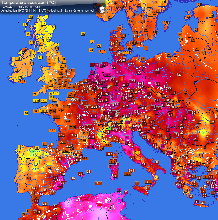
Unique! The netherlands is the warmest place in Europe pic.twitter.com/V6v8XGMbIc
source: https://twitter.com/weermanrobert/status/490503015313727488/photo/1
-
-
Polar Invasion Spawns Colorado Storms, Turning Lawns White With Hail (Jul 14)
It's not supposed to snow in the middle of July, is it?
While the storm that whitened lawns in parts of Colorado on Monday was the result of the polar air shoving its way south into a typically warm and moist July air mass, it wasn't a snowstorm.
Instead, it was hail that blanketed the ground in Berthoud, Colorado, on Monday. Several other Colorado communities also found themselves caked in accumulating hail as thunderstorms raked the state.
The thunderstorms formed along a front separating the unseasonably chilly polar air over the Upper Midwest from monsoonal moisture over the Southwest and the typical heat and humidity normally present over the South in mid-summer. Disturbances in the upper atmosphere and lift from winds blowing westward into the Rocky Mountains have further enhanced the thunderstorm activity over Colorado.
Berthoud is a city in Larimer and Weld counties of north-central Colorado. The two counties have had a combined 54 severe thunderstorm warnings issued by the National Weather Service so far in 2014, according to data compiled by Iowa State University. Of those 54 warnings, 53 have been issued since the beginning of May.
Source
http://www.weather.com/news/weather-severe/polar-invasion-colorado-...
© 2025 Created by 0nin2migqvl32.
Powered by
![]()
You need to be a member of Earth Changes and the Pole Shift to add comments!
Join Earth Changes and the Pole Shift