Giant waves crash over seawalls during a storm

in the suburbs of Taipei, Taiwan. 21.10.2025

"We warned at the start of ZetaTalk, in 1995, that unpredictable weather extremes, switching about from drought to deluge, would occur and increase on a lineal basis up until the pole shift. Where this occurred steadily, it has only recently become undeniable. ZetaTalk, and only ZetaTalk, warned of these weather changes, at that early date. Our early warnings spoke to the issue of global heating from the core outward, hardly Global Warming, a surface or atmospheric issue, but caused by consternation in the core. Affected by the approach of Planet X, which was by then starting to zoom rapidly toward the inner solar system for its periodic passage, the core was churning, melting the permafrost and glaciers and riling up volcanoes. When the passage did not occur as expected in 2003 because Planet X had stalled in the inner solar system, we explained the increasing weather irregularities in the context of the global wobble that had ensued - weather wobbles where the Earth is suddenly forced under air masses, churning them. This evolved by 2005 into a looping jet stream, loops breaking away and turning like a tornado to affect the air masses underneath. Meanwhile, on Planet Earth, droughts had become more intractable and deluges positively frightening, temperature swings bringing snow in summer in the tropics and searing heat in Arctic regions, with the violence of storms increasing in number and ferocity."

ZETATALK

Wild Weather, the Wobble Effect - Earth Changes and the Pole Shift

Views: 637109

Comment

You need to be a member of Earth Changes and the Pole Shift to add comments!

Join Earth Changes and the Pole Shift

Comment by KM on December 25, 2015 at 1:49am

http://www.dailymail.co.uk/wires/ap/article-3372474/Paraguay-Floods...

Paraguay: Floods force evacuation of more than 70,000

Authorities say the Paraguay River rose to nearly 24 feet (7.2 meters) Wednesday after weeks of torrential rains. That's near its highest level of 1983, when it reached 25.3 feet (7.72 meters).

Paraguay's National Emergency Secretariat says about 72,000 people have been forced out of their homes in the Paraguayan capital.

Victor Ferreira, who is displaced by flooding, rows his boat through the streets of his Jukyty neighborhood in Asuncion, Paraguay, Wednesday, Dec. 23, 2015. ...

Victor Ferreira, who is displaced by flooding, rows his boat through the streets of his Jukyty neighborhood in Asuncion, Paraguay, Wednesday, Dec. 23, 2015. The Paraguay River is at its highest level since 1984 and threatening the poor districts that surround the capital, forcing about 100,000 people to shelters. (AP Photo/Jorge Saenz)

But many more are expected to be affected nationwide by the swelling of the Parana and other rivers.

Communities living in low-lying slums are especially at risk.

Most are seeking shelter in camps on higher ground, where they're sleeping in improvised tents.

Congress issued a state of emergency last week and authorized the government to spend $4 million to assist flood-hit families.

Comment by KM on December 23, 2015 at 2:48am

http://nypost.com/2015/12/20/submerged-secrets-are-revealed-as-silv...

Submerged secrets are revealed as Silver Lake dries up

Staten Island’s Silver Lake is giving up decades of soggy secrets — from a vandalized street sign to an old motorcycle — as the massive city reservoir mysteriously drains away.

The water level is down six to seven feet since early October, photo comparisons show.

Leaks underneath the lake are going unaddressed by the city Department of Environmental Protection, which has also stopped pumping water into the lake.

The 56-acre lake was built as a city reservoir in 1917, but hasn’t been used for drinking water since 1971. Today, underground storage tanks next to the lake supply Staten Island’s water.

The lake collects the tanks’ overflow, and forms the centerpiece of picturesque Silver Lake Park.

The water hasn’t been this low since the early 1980s,” said parkgoer Patty Ribeiro, who lives nearby.

In 1982, an interagency battle halted water flow into the lake for a year, sparking local uproar that made the lake’s maintenance a DEP responsibility.

Ribeiro sees more debris each day as the water recedes: “a plastic toy scooter, a rubber raft, traffic cones, broken ladders.”

The motorcycle, once totally submerged, is now eight feet from the water’s edge.

“You’d sometimes just see the tip of the wheel,” Ribeiro said of the landmark she uses to gauge the lake’s depth.

The draining of the lake came as a shock to leaders of local civic groups, including Dominick DeRubbio of the Silver Lake Conservancy.

“Maybe we can take advantage of this situation,” DeRubbio said, referring to the cleanup efforts of the now-dried up depths.

The DEP would not say how low the water level will go or when the lake will be restored.

Comment by KM on December 22, 2015 at 1:19pm

http://strangesounds.org/2015/12/sandstorm-boulia-queensland-austra...

Powerful sandstorm engulfs the city of Boulia, Queensland, Australia

An unusually powerful sandstorm swept through the central-western part of the Australian state of Queensland on Decmber 16, 2015.

And it turned the day into night at Boulia, where a strong wind was blowing during a few hours, cars were forced to stop.

sandstorm Queensland Boulia, sandstorm Boulia Queensland, sanstorm Boulia pictures, sandstorm Queensland Boulia photos, wall of sand engulfs queensland, queensland unusually strong sandstormAnd suddenly a wall of sand appeared at horizon. By Ann Britton
sandstorm Queensland Boulia, sandstorm Boulia Queensland, sanstorm Boulia pictures, sandstorm Queensland Boulia photos, wall of sand engulfs queensland, queensland unusually strong sandstorm
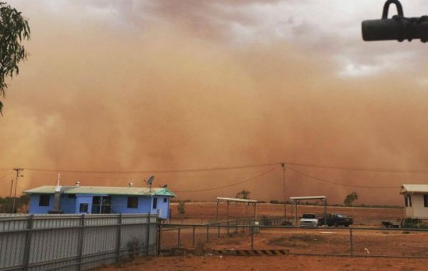
The storm swept through Boulia in Queensland. By Ann Britton
sandstorm Queensland Boulia, sandstorm Boulia Queensland, sanstorm Boulia pictures, sandstorm Queensland Boulia photos, wall of sand engulfs queensland, queensland unusually strong sandstorm
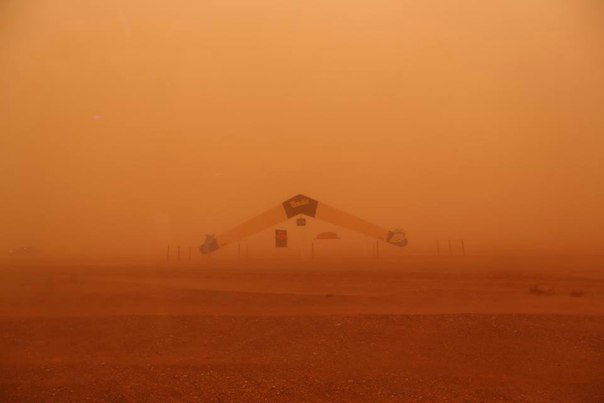
And turned the day into night. 

Watch a hundred-meter-high wall of sand engulfing a city… It’s insane.

Comment by jorge namour on December 22, 2015 at 3:48am

Softness record: the real reasons

News - Updated Monday, December 21, 2015 by The Weather Channel- LA CHAINE METEO

The exceptional softness affects almost the entire northern hemisphere. What are the reasons for the persistent discrepancy?

The record Softness that remains relates much of the northern hemisphere.

Softness to Eastern America and EUROPE . anticyclone mediterranean. . jet stream makes ripples that make up the heat on the east coast of the United States but also to the west of EUROPE.

While the cold is contained and condensed at the North Pole and Greenland.

Since autumn 2015 COLD is intense at high latitudes on the Arctic Greenland, temperature MINUS 50 degrees.

POLARF VORTEX

the polar vortex does not happens TO FALL ELAPSE this is why there is no cold wave on the American continent and europe.

POLAR VORTX seen above the North Pole
belt around the pole and this vortex keeps the cold at ArcticS.SO prevents the cold to elapse to fall
to Russia, `North America and Europe .

SO IT contributes to Softness generalized except at the pole.

http://actualite.lachainemeteo.com/actualite-meteo/2015-12-21-05h41...

https://translate.google.com/translate?sl=fr&tl=en&js=y&...

Comment by Poli on December 21, 2015 at 11:57pm

Advent, Advent,
Europe is burning!

► winter too warm ► Even in Scandinavia Plus Grade
► the polar bear melt away the clods
A December on record course: In Germany, the last month of the year so far with an average of 6.2 degrees is much too warm - namely whopping 5.5 degrees!
► The US Forecast Centres (National Centers for Environmental Prediction; short NCEP) forecast for the coming days temperatures that differ significantly from the winter average.
While we can expect more with four to five degrees in Germany, Eastern Europe lays in the calculations eight to ten degrees!
The whole of Europe is sweating. December is in Europe too mild. As with us there will be for example in France most likely the warmest December since records began.
The expert: "The Atlantic and the Mediterranean have still partially up to 20 degrees warm water. This is completely unusual. "
... and so similar in Norway, England, Austria, Moscow.

http://www.bild.de/news/inland/wetter/temperaturen-auf-rekordkurs-h...

Comment by KM on December 18, 2015 at 1:09pm

http://www.thebigwobble.org/2015/12/the-weather-has-gone-mad-warm.html

The weather has gone mad! warm temperatures being broken in the UK, Europe and US as Daffodils bloom in December! December set to be warmest on record along with 2015 set to be warmest year on record!


December set to be the warmest on record across the UK and many parts of Europe as the jet-stream is stuck above the UK and it is sucking warm air from northern Africa bringing balmy temperatures more accustomed to early May than December.
Yesterday here in Holland, just north of Amsterdam, I enjoyed temperatures hovering around 18C, or around 65F in old money, uncanny when you realise the average temperature here for this time of the year is 5C or 41F.
Daffodils are blooming across the  UK and parts of Europe during unseasonal December weather
Flowers usually more associated with Easter than Christmas seen around the country in a week of above-average seasonal temperatures.
Daffodils in December!
Incredibly, the forcast for today is set to be even warmer than yesterday and tomorrow will be the warmest day of all, so records are sure to be broken.
December will probably be the warmest on record along with November 2015 which was the warmest November on record, with 2015 will be the warmest year on record, maybe Al Gore was right after all?
It's not all good news though for the UK.
A series of storms will accompany the mild weather across the United Kingdom into Christmas, threatening to causing more floods and disruptions to travel for millions before and after the holiday. 
Also asthmatics in Britain are preparing for a Saharan dust cloud to hit the country.
Forecasters said Saharan dust picked up by winds and carried in the atmosphere could fall in the South East, leaving a yellow or brown film on cars.
The phenomenon is often dubbed ‘blood rain’, but this reddish precipitation is only officially seen in countries with much higher red dust concentrations.

Across the pond it's the same story with, no sign of the polar vortex which devastated the US just one year ago when parts of America was colder than Mars, temperatures along the north east and Midwest have been in the 70's, around 23C, warm enough for shorts and t-shirt.
But just like the UK a series of storms more typical of spring will bring rounds of drenching rain to much of the eastern third of the nation during the week of Christmas.
Comment by KM on December 17, 2015 at 10:32pm

http://sputniknews.com/videoclub/20151217/1031908390/california-bea...

Rising Tide: Beach in California Swallowed by Ocean

An interesting weather phenomenon occurred on the West Coast of the US.

Whether it was caused by El Nino or not, the Carlsbad State Beach was almost completely swallowed by the ocean.


Comment by KM on December 17, 2015 at 10:27pm

http://www.theweathernetwork.com/news/articles/must-see-5-unearthly...

Must See: 5 unearthly shots of massive outback dust storm

 A “larger than normal” dust storm billowed through the Australian outback town of Boulia Tuesday, creating an otherworldly spectacle.

Local photographers jumped at the opportunity to capture the Martian-like moment, where visibility was reportedly limited to just a few metres.

Although dust storms are common in the area, lifestyle photographer Ann Britton told the Brisbane Times that Tuesday’s happening was substantially larger than usual.

The outback is known for being Australia’s vast, mostly uninhabited desert region, where temperatures can soar to 50 C in the summer, while dipping to – 10 C in the winter.

Comment by KM on December 16, 2015 at 12:41pm

https://www.rt.com/news/326071-australia-storm-tornado-sydney/

Freak storm rips though Sydney with tornadoes, flooding, hail, 200kph winds 

© Kang Seblak
A destructive storm has hit Sydney, Australia, bringing tornadoes, flooding, golf-sized hail stones, and up to 213 kilometer per hour winds, which caused serious damage, triggered evacuations, and trapped people indoors.

A Sydney suburb was labeled a disaster zone after a tornado ripped through its southern beaches with golf-sized hail stones and rattling winds that caused tremendous damage to the neighborhood.

The disaster toll already looks steep: over 10,000 homes and around 7,000 businesses have been left without electricity. State Emergency Service (SES) has received at least 160 calls out.

Heavy winds have torn roofs from houses, triggering evacuations in Sydney. 

One of the biggest evacuations took place at the desalination plant in Kurnell. Staff was told to leave the Caltex refinery immediately, after it suffered significant damage from the storm.

Part of the roof collapsed at the Shoppers at Westfield mall in Bondi Junction, causing flooding and forcing quick evacuations. The major shopping center remains closed.

“There is flooding and people are being moved out of the mall,” Conor McGuinness told The Australian. 

Flights are being delayed at Sydney’s airport, according to an airport spokeswoman.

In another shocking moment, a palm tree caught fire when it was struck by lightning in Sydney.

Some of the photos posted online show flipped and damaged cars, as well as flooded streets with random objects blown by the winds.

Social media users had posted pictures of ominous-looking dark grey clouds, resembling movie scenes from the end of the world, prior to the storm lashing out.

The freakishly strong winds have now moved offshore from Bondi Beach, according to the Bureau of Meteorology. However, a severe thunderstorm warning is still in effect for parts of Sydney and New South Wales.

More storm outbreaks are expected throughout the day.

Comment by Mark on December 16, 2015 at 10:43am

UK weather: Britain facing hottest Christmas on record

Southern England will be hotter than parts of Australia over the next few days thanks to sub-tropical air

http://www.mirror.co.uk/news/uk-news/uk-weather-britain-facing-hott...

Bookies have slashed the odds on Christmas Day being the warmest on record as the freak December mild spell continues.

Temperatures in southern England will be hotter than parts of Australia over the next few days thanks to sub-tropical air.

And forecasters say the balmy weather is here to stay - with Christmas Day predicted to be exceptionally warm.

Ladbrokes cut the odds of temperatures breaking the December 25 record of 15.6C from 10/1 to 3/1.
Spokeswoman Jessica Bridge said: "It looks like sunglasses rather than snowmen on Christmas Day."

The forecast is bad news for snow lovers - with only parts of the Scottish Highlands expected to see the white stuff.

SEARCH PS Ning or Zetatalk

 
Search:

This free script provided by
JavaScript Kit

Donate

Donate to support Pole Shift ning costs. Thank you!