Wild Weather, the Wobble Effect
Massive flooding in Da Nang, Vietnam. 30.10.2025.
Giant waves crash over seawalls during a storm
in the suburbs of Taipei, Taiwan. 21.10.2025
"We warned at the start of ZetaTalk, in 1995, that unpredictable weather extremes, switching about from drought to deluge, would occur and increase on a lineal basis up until the pole shift. Where this occurred steadily, it has only recently become undeniable. ZetaTalk, and only ZetaTalk, warned of these weather changes, at that early date. Our early warnings spoke to the issue of global heating from the core outward, hardly Global Warming, a surface or atmospheric issue, but caused by consternation in the core. Affected by the approach of Planet X, which was by then starting to zoom rapidly toward the inner solar system for its periodic passage, the core was churning, melting the permafrost and glaciers and riling up volcanoes. When the passage did not occur as expected in 2003 because Planet X had stalled in the inner solar system, we explained the increasing weather irregularities in the context of the global wobble that had ensued - weather wobbles where the Earth is suddenly forced under air masses, churning them. This evolved by 2005 into a looping jet stream, loops breaking away and turning like a tornado to affect the air masses underneath. Meanwhile, on Planet Earth, droughts had become more intractable and deluges positively frightening, temperature swings bringing snow in summer in the tropics and searing heat in Arctic regions, with the violence of storms increasing in number and ferocity."
ZETATALK
Wild Weather, the Wobble Effect - Earth Changes and the Pole Shift
Views: 637732
Comment
-
Comment by Juan F Martinez 7 hours ago
-
Two dead as Typhoon Kalmaegi slams into Philippines with winds up to 200kmph, November 4, 2025.
Floodwaters in Cebu city reach ‘up to heads of people’ as typhoon dumps month’s worth of rain in less than 24 hours
Rescue teams raced to reach people stranded in central Philippines after Typhoon Kalmaegi barreled through overnight, causing flooding across multiple provinces, leaving at least two people dead and many trapped on rooftops.
Locally referred to as Tino, the typhoon made landfall around midnight in Silago in the eastern province of Southern Leyte, with sustained winds of up to 140kmph and gusts of up to 195kmph.
Kalmaegi is the 20th tropical cyclone of the year to strike one of the world's most disaster-prone countries, which is frequently battered by volcanic eruptions and earthquakes as well.
The latest storm dropped a month’s worth of rain in two areas of Visayas, one of the country’s three main island groups, in under 24 hours, according to weather bureau PAGASA.
VIDEO: https://t.me/ZetaTalk_Followers/78750
https://www.independent.co.uk/asia/southeast-asia/typhoon-kalmaegi-...
-
Comment by Tracie Crespo 8 hours ago
-
https://www.bbc.com/news/articles/cgmx4yjkzj4o
At least three dead as typhoon causes devastation in the Philippines
2 hours agoGeorge Wright
Moment Philippines floods move shipping containersAt least three people have been killed and hundreds of thousands have been forced to flee their homes as a typhoon ripped through the central Philippines, the country's disaster agency said.
Typhoon Kalmaegi has flooded large areas, including entire towns on the island of Cebu.
Videos show people sheltering on rooftops, while cars and shipping containers have been swept through the streets.
A military helicopter deployed to assist relief efforts crashed in northern Mindanao island, the Philippine Air Force (PAF) said. It is not yet clear if there were any survivors of the crash.
It is forecast to move across the Visayas islands region and out over the South China Sea by Wednesday.
"The situation in Cebu is really unprecedented," provincial governor Pamela Baricuatro said in a Facebook post.
"We were expecting the winds to be the dangerous part, but... the water is what's truly putting our people at risk," she said.
"The floodwaters are just devastating."
Don del Rosario, 28, was among those in Cebu City who sought refuge on an upper floor as the storm raged.
"I've been here for 28 years, and this is by far the worst we've experienced," he told the AFP news agency.
In a statement, the PAF said a rescue helicopter went down near Agusan del Sur on Mindanao island.
"Communication with the helicopter was lost, which immediately prompted the launch of a search and rescue operation," it said, adding that further details will be released "as they become verified".
In total, almost 400,000 people were moved from the typhoon's path, Rafaelito Alejandro, deputy administrator at the Office of Civil Defence, told a news conference.
 AFP via Getty Images
The latest comes barely a month after back-to-back typhoons killed over a dozen people and wrought damage to infrastructure and crops.
Super Typhoon Ragasa, known locally as Nando, struck in late September, followed swiftly by Typhoon Bualoi, known locally as Opong.
In the months before, an extraordinarily wet monsoon season caused widespread flooding, sparking anger and protests over unfinished and sub-standard flood control systems that have been blamed on corruption.
On 30 September, dozens were killed and injured after a powerful 6.9 magnitude earthquake struck the central Philippines, with Cebu bearing the brunt of the damage.
-
-
Destructive tornado hits Sumbersekar Village in Malang, East Java, Indonesia (02.11.2025)
VIDEO: https://t.me/ZetaTalk_Followers/78684Wild Weather, the Wobble Effect
https://poleshift.ning.com/profiles/blogs/wild-weather
-
-
-
Massive flooding in Da Nang, Vietnam. 30.10.2025.
VIDEO: https://t.me/ZetaTalk_Followers/78591
Wild Weather, the Wobble Effect
https://poleshift.ning.com/profiles/blogs/wild-weather
-
-
Massive flooding in Hoi An, Quang Nam, Vietnam. 28.10.2025.
-
-
MOUNT DORA, Florida
Florida roads and yards were left washed out and heavily damaged after weekend storms.
-
-
https://www.usatoday.com/story/news/weather/2025/10/27/hurricane-me...
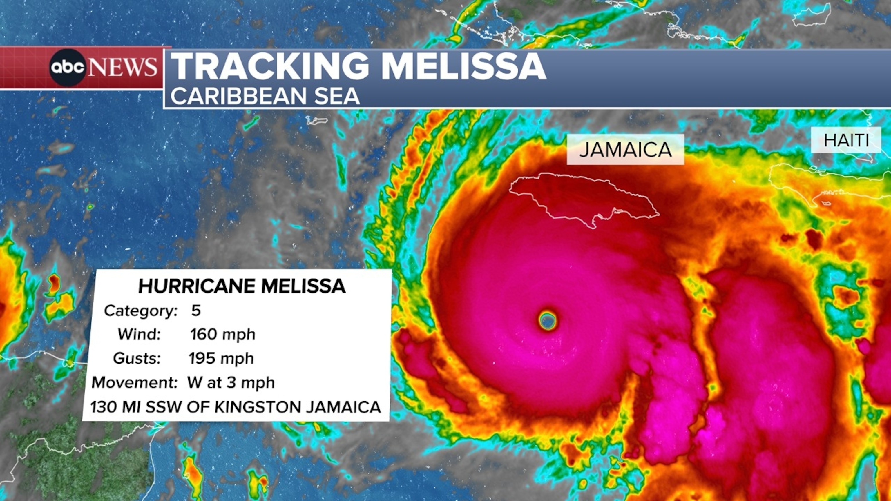
Hurricane Melissa strengthens to a Category 5 storm, heads for Jamaica
USA TODAYHurricane Melissa intensified to a Category 5 storm as it neared Jamaica where officials evacuated low-lying areas and opened hundreds of shelters in preparation of "life-threatening" storm conditions.
Melissa was centered about 135 miles south-southwest of Kingston, Jamaica, according to the latest update from the National Hurricane Center. The storm had maximum sustained winds of 160 mph and was moving at a slow 3 mph.
The storm was expected to make landfall in Jamaica early this week before approaching Cuba and the Bahamas. Forecasters anticipate Melissa will enter the Atlantic, but avoid a direct hit along the eastern coast of the United States.
Fueled by the warm waters of the Caribbean, the storm has steadily grown in intensity and is on track to be one of the strongest to directly hit Jamaica in recent history. Further strengthening is expected on Oct. 27, forecasters said."Preparations to protect life and property should be complete in Jamaica and rushed to completion in Cuba," the hurricane center said in a forecast outlook.
Jamaica prepares for landfall, floodwaters inundate Hispaniola
Jamaica and Hispaniola could see upwards of 30 inches of rain, forecasters said, warning of mudslides and "life-threatening flash flooding." Peak storm surge could reach 9 to 13 feet above ground level, and will be accompanied by destructive waves.
Through the midweek, eastern Cuba could see up to 20 inches of rain, as 9-foot waves crash along the coast.
The storm has already begun to wreak havoc. At least three deaths in Haiti have been linked to Melissa, according to the Associated Press. The storm has also inundated parts of the Dominican Republic, damaging over 100 homes and knocking out water service in several parts of the country, officials said.
In Jamaica, tourists evacuated as officials moved to close the nation's airports and open over 800 shelters ahead of the storm's arrival.
Melissa is the latest major hurricane to form in Atlantic Basin
Melissa is the fifth hurricane of the 2025 Atlantic hurricane season and the latest to reach major hurricane status, joining Erin, Gabrielle, Humberto and Imelda. The only system to make landfall along the eastern U.S. coast this season was Tropical Storm Chantal in July.
Most preseason forecasts predicted a busier-than-average season, which hasn't quite panned out as of late October.
The peak of the Atlantic hurricane season is Sept. 10, with most activity occurring between mid-August and mid-October, according to the National Hurricane Center. But while activity typically diminishes in November, there still remains a threat of storms in the Atlantic and the Gulf.
Contributing: Doyle Rice and Eduardo Cuevas; Reuters
------------------------------------------------------------------------------------------------------------------------------------------------------------
Hurricane Melissa intensifies to Category 5 storm, threatens Jamaic...
------------------------------------------------------------------------------------------------------------------------------------------------------------
Hurricane Melissa live updates: Jamaica braces for its worst storm ...
-
-
Flash flood in San Martin, Buenos Aires, Argentina. 25.10.2025.
-
-
Sunrise over Category 4 Major Hurricane Melissa, 115 miles south of Kingston, Jamaica. 26.10.25
Switch to the Mobile Optimized View
© 2025 Created by 0nin2migqvl32.
Powered by
![]()
You need to be a member of Earth Changes and the Pole Shift to add comments!
Join Earth Changes and the Pole Shift