Volcano watch
Benevolent extraterrestrials monitoring volcanoes to provide early warning to human partners.
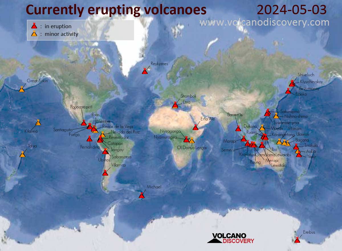
Volcanic activity worldwide 18 October, 2025: Kilauea in Hawaii, Santiaguito volcano, Fuego, Semeru, Ibu, Dukono, Reventador, and soon "all volcanoes that have been active within the memory of man will begin spewing and burping and oozing, and many that were not expected to become active will reactive."
"Of course, all volcanoes will explode, as this is going to be a very severe pole shift. What about the months and years preceding the pole shift? It is no secret that Mammoth Lake and the caldera of Yellowstone are warming up, and the populace has been prepared for these occurrences by the movie Volcano where there, in the middle of LA, lava is bubbling up. In fact, there is a fault line running from the approximate San Diego/LA area, up into the Sierras, and this is liable to rupture rather violently during one of the quakes that precedes the pole shift by some months. Volcanic eruptions from that area in the Sierras can be expected. Will Mount St. Helen erupt? All volcanoes that have been active within the memory of man will begin spewing and burping and oozing, and many that were not expected to become active will reactive." ZetaTalk - Feb 15, 2000
Views: 222443
Comment
-
Comment by Sevan Makaracı on September 9, 2011 at 3:35pm
-
SEP 9 :
Indonesia - Mount Tambora alert status raised to Level 3
Google Translate:
Centre for Volcanology and Geological Disaster Mitigation, issue a proclamation increasing the status of Mount Tambora in Dompu and Bima Regency West Nusa Tenggara Province from alert status to Alert Level II Level III.
In a telegram sent to the district government Dompu, numbered 667/45.03/BGV/2011 detailing letusannya famous volcanic activity with the victim during the entire history, no longer have exhaled smoke is the crater, said the Head of Active Mount Observation Post (PGA) Tambora, Abdul Haris, which is accessible from Dompu, Friday (9 / 9).
"Even though there is no exhaled smoke is the crater, but we do not disconnect status. We still continue to observe all the activity of Mount Tambora," said Abdul Haris Observation Post Mount Head On (PGA) Tambora.
It adds visual observations made since the date of 30 August to 8 September 2011, all the exhaled smoke is observed craters. But on 31 August last, there were 13 earthquakes in the location of Mount Tambora.
It asks people, especially in Sub Concentrated five villages inside the foot of Mount Tambora as Country Doropeti, Concentrated, Sorinomo, Pancasila and Nangamiro to not approach the mountain.
"Line of climb for a while we are closed, as well as we reflect on people who do the activities on the slopes of Mount Tambora to undo his intention," he said.
Each activity changes of Mount Tambora on the handicapped and reported regularly to the Centre for Volcanology and Geological Disaster Mitigation in Bandung. The report also presented to the two nearest local governments that Bima and Dompu.http://www.republika.co.id/berita/nasional/umum/11/09/09/lr8r06-sta...
-
-
SEP 9 :
Seismic activity, misc.
The following super volcanoes have had seismic activities as follows;
Whakamaru 2011-09-06 11:56:03 2.6 5 Km
Yellowstone 2011-09-06 13:18:26 2.3 2.00 Km
Campi Flegrei 2011-09-06 10:47:28 5.0 25 Km
Reporoa 2011-09-06 11:56:03 2.6 5 Km
http://hisz.rsoe.hu/alertmap/index2.php
-
-
SEP 9 :
More harmonic tremors in Katla volcano
It seems that Katla volcano is not as quiet it seems to be. For the moment the harmonic tremor seems to be small and only properly observable on one SIL station due to how weak it is at current time. So far two harmonic spikes have happened. This is most likely a hydrothermal system going crazy under the glacier close to Lágu Hvolar SIL station, rather then magma on the move (or at least that is what I think).
Harmonic tremor at Lágu Hvolar SIL station. The harmonic tremor can be seen at the end of this tremor plot. Copyright of this picture belongs to Iceland Met Office.
There has not been a lot of earthquake activity in Katla volcano during the last 24 hours or so. But that might not mean anything, as eruption can and have started without any warning at all (example: Grímsvötn volcano May 2011). So for now, it is more wait and see and more waiting it seems.
-
-
SEP 8 :
Iceland, Katla volcano - Iceland’s Civil Protection Department has increased its monitoring of Katla, following increased seismic activity in the surrounding area
Iceland’s Civil Protection Department has increased its monitoring of the North Atlantic island’s largest volcano, Katla, following increased seismic activity in the surrounding area, according to a statement on its Web Site. “We can’t rule out that” an eruption is under way, Magnus Tumi Gudmundsson, a geologist at the Institute of Earth Science with the University of Iceland, told national broadcaster RUV. “It’s possible that magma is gathering underneath the mountain.” Gudmundsson said it was too early to say exactly what was happening at the volcano. Three earthquakes were measured in the Katla area after 7 p.m. local time, according to Iceland’s Meteorological Office. The largest quake was about 2.0 on the Richter scale, the Met Office said. Katla had two small eruptions in 1955 and 1999, neither of which managed to break the ice covering its 10 kilometer-wide (6 mile) caldera. The last major eruption in Katla began in 1918, when ash explosions from the crater didn’t subside for more than five weeks. Ash from Iceland’s Grimsvotn volcano forced flight cancelations in Scotland, northern England and Germany in May. An eruption of the Eyjafjallajokull volcano in April last year caused the cancellation of more than 100,000 flights on concern glass-like particles formed from lava might melt in aircraft engines and clog turbines. Historically, Eyjafjallajokull has been known to erupt one to two years prior to Katla.
http://hisz.rsoe.hu/alertmap/site/?pageid=event_update_read&edi...
-
-
SEP 7 :
Iceland, Katla volcano - Magma on the move in Katla volcano / Increased geothermal heat and seismic activity might indicate an upcoming eruption
While the source of the harmonic tremor yesterday in Katla volcano is not immanently clear. It is has been concluded that magma is on the move inside Katla volcano. It has been suggested that the harmonic tremor yesterday in Katla volcano is a mixture of both hydrothermal activity and water flows under the glacier. But hydrothermal activity has increased in Katla volcano since July and seems to be continuing on that path for now.
The earthquake activity in Katla volcano has been growing since July, when a sharp harmonic tremor spike did take place and was followed by a glacier flood that did destroy the Múlakvísl river bridge. But that flood did peak at ~5 meter high.
Currently the activity is quiet in Katla volcano. But that might be because the earthquakes are not being detected by the bad weather that is currently in this area (and all over Iceland for the fact).
Here is a overview of the change in activity since Week 34.
Update 1: According to news the local emergency units and police have started to review the evacuation plans and emergency plans in the case of a eruption in Katla volcano.
News about that can be read here, if you risk Google Translate.
Fara yfir áætlanir um viðbrögð (mbl.is, Icelandic, 7. Sept, 2011)
RSOE - Increased geothermal heat and seismic activity below Mýrdalsjökull glacier in south Iceland, which covers the volcano Katla, might indicate an upcoming eruption and scientists are closely monitoring the volcano. However, it is not certain that an eruption is imminent. Mýrdalsjökull and Mt. Maelifell. Photo by Páll Stefánsson. Geophysicist Magnús Tumi Gudmundsson went on an observation flight over Mýrdalsjökull yesterday. “There is always uncertainty regarding Katla and therefore it was considered necessary to fly across the glacier to shed a light on what is going on,” he told Fréttabladid. He noted that calderas and cracks in the glacier clearly showed increased geothermal heat and regular series of minor earthquakes also indicate that the volcano has been expanding recently. Gudmundsson pointed out that there is only one definite indication that an eruption in Katla is coming up. “All sources of Katla eruptions in the past 500 years mention large earthquakes that can clearly be found in Mýrdalur [by Vík] a few hours before the eruption begins. That is in fact the only absolute warning.” There was some seismic activity below Mýrdalsjökull yesterday but this morning it seemed to have subsided. The glacial river Múlakvísl also flooded but the water level peaked yesterday evening and the water flow has since decreased, ruv.is reports. The calderas which caused the flood in Múlakvísl in July are unchanged but Gudmundsson said there is a new depression in the icecap to the south of them which indicate increased geothermal heat. He added there is no clear reason for yesterday’s earthquakes.....http://hisz.rsoe.hu/alertmap/site/?pageid=event_update_read&edi...
-
-
SEP 7 :
Alaska, Cleveland volcano - Remote Alaska volcano might erupt soon, experts say
Alaska's Cleveland Volcano could soon be leaking from its flanks if the lava inside continues to build up, officials at the Alaska Volcano Observatory reported.
The observatory reported that the volcano's lava dome was 262 feet in diameter on August 30 and has now expanded to 394 feet.
"The presence of the lava dome increases the possibility of an explosive eruption, but does not necessarily indicate that one will occur," the observatory said. "Short-lived explosions could produce an ash cloud that exceeds 20,000 ft above sea level."
The observatory said it did not expect air travel problems if the volcano erupted.
Because "the small lava dome in the summit crater has resumed growth and now fills the floor of the crater," the observatory is raising its alert level.
The remote volcano is in the Aleutian Islands, about 940 miles southwest of Anchorage.
Because the volcano is in such a remote area, the observatory webcam feed has experienced technical difficulties.http://news.blogs.cnn.com/2011/09/07/remote-alaskan-volcano-might-e...
-
-
SEP 7 :
Hawaii, Kilauea volcano - The summit lava lake rose slightly overnight at Pu`u `O`o crater
Eruptive activity persisted within Pu`u `O`o crater and at Kilauea’s summit amidst continued inflation. The summit lava lake rose slightly overnight. In the middle east rift zone, lava continued to issue from sources at the east and west edges of the Pu`u `O`o crater. Seismic tremor levels remained low. Gas emissions remained elevated from summit and rift zone vents. All erupted lava is confined to craters within Hawai`i Volcanoes National Park and poses no direct hazard to any developed areas.
The summit … (Source)
-
-
SEP 6 :
Mount Duokono North Halmahera erupted belching volcanic ash as high as 800 meters
Duokono mountain in North Halmahera, North Maluku, on Tuesday (6 / 9), erupted belching volcanic ash as high as 800 meters. Residents were asked to evacuate at least about two kilometers from the foot of the mountain.
Head Mount Observation Post Duokono Iwan Ahmad said, before the eruption, volcanic earthquakes occurred dozens of times every day. Nowadays the mountain is located in the District was issued a fungus Galela volcanic dust high enough so that it can be seen from Ternate. The mountain is in standby status.
Iwan adding a mountain as high as 2,300 meters above sea level last erupted in 2008. (ADI / Ulf)VIDEO : http://tv.liputan6.com/main/read/6/1063350
http://berita.liputan6.com/read/352171/gunung-duokono-halmahera-uta...
-
-
SEP 6 :
Indonesia’s Mount Lokon erupts four times on Tuesday
MANADO, SULAWESI (BNO NEWS) -- Indonesia's Mount Lokon erupted four times on Tuesday after increasing its volcanic activity during the past week, officials said.
Mount Lokon, which is located on the northern tip of the island of Sulawesi, had four small eruptions on Tuesday, spewing out materials between 150 and 200 meters (492 to 656 feet), Warno, an officer at the Mount Lokon and Mount Mahawu observation post at Kakaskasen village told the Antara news agency.
The first eruption took place at 7:21 a.m. local time and the fourth 2:20 p.m., producing thick white and gray smoke. According to Warno, this means water and gases are still being burned in the crater.
As of 6 p.m. local time on Tuesday, only one volcanic tremor was recorded on Tuesday, compared to Monday's two deep volcanic tremors as well as four distant tectonic quakes. The amplitude of the latest tremors ranged between 0.5 millimeters and 10 millimeters. Despite their amplitude declining compared to previous ones, Warno said magma was still being pushed upwards.
Officials at the Volcanic and Geological Disaster Mitigation Center have kept the volcano's alert status to level III, even though the geological activity has began decreasing.
Mount Lokon has shown constant volcanic activity since June, prompting authorities to raise its status to Alert on June 27 and Watch on July 10. A series of eruptions in mid-July forced at least 5,269 locals from the villages of Kinilow, Kelurahan Kinilow I and Kakaskasen 1 to evacuate the area.
While most residents returned to their homes later that month, some 222 people remain at temporary refugee camps because their homes are in Mound Lokon's red zone - 3 kilometers (1.86 miles) from its crater. After July's activity, Mount Lokon's alert level was lowered from Watch to Alert, and has remained at this level since.
On August 17, Mount Lokon began to spew volcanic ash which fell as far away as the Kinilow I village and the Tinoor areas in North Tomohon sub district, which is a short distance from Lokon's crater. And on August 28, it erupted as many as 12 times. Monitoring staff recorded 65 deep volcanic earthquakes and 93 shallow earthquakes that day.
Dozens of active volcanoes in Indonesia are part of the Pacific Ring of Fire, known for frequent earthquakes and volcanic eruptions. Next to Mount Lokon is its volcanic twin, Mount Empung, just 2.2 kilometers (1.3 miles) away.
One of Indonesia's most active volcanoes is Mount Merapi, which is located on the island of Java near Jogjakarta, the country's second-most visited area after Bali. Last year, more than 300 people were killed in a series of eruptions between October and November which also displaced over 300,000 people.http://channel6newsonline.com/2011/09/indonesias-mount-lokon-erupts...
-
-
SEP 6 :
Remote Alaska volcano resumes dome building
The lava dome at a remote Alaska volcano has resumed growing, prompting officials to raise its alert level. The dome now fills the floor of the crater at Cleveland Volcano, 940 miles southwest of Anchorage. The Alaska Volcano Observatory on Tuesday raised the volcano's alert level to watch status. The threat level was dropped on Aug. 30, but raised against after a persistent thermal anomaly started Saturday. Observatory officials say in a news release that's when the lave dome likely started growing again. The dome was 262 feet in diameter on Aug. 30, but is now about 394 feet in diameter. Officials say if that continues, lava flows could start on the flanks of the volcano. The growing dome also increases the possibility — but doesn't ensure — an explosive eruption.http://www.adn.com/2011/09/06/2052236/remote-alaska-volcano-resumes...
http://hisz.rsoe.hu/alertmap/site/?pageid=event_update_read&edi...
SEARCH PS Ning or Zetatalk
Nancy Lieder, Emissary of the Zetas.
https://poleshift.ning.com/xn/detail/3863141:Comment:1168188
Awakening to the Alien Presence ZetaTalk
The truth will likely never to be known to the public but be washed away in the Nibiru panic soon to engulf the world.
The Worst of the Cover-Up
https://poleshift.ning.com/profiles/blogs/the-worst-of-the-cover-up
Main Establishment Lies
https://poleshift.ning.com/profiles/blogs/main-establishment-lies
Donate
© 2025 Created by 0nin2migqvl32.
Powered by
![]()
You need to be a member of Earth Changes and the Pole Shift to add comments!
Join Earth Changes and the Pole Shift