Please Place Evidence of the 7 of 10 Plate Movements Here
Kojima had created small snips of Konstantin's animation of the 7 of 10 Plate Movements.
Here is the full 7 of 10 Animation by Konstantin.
This blog is the place to document ongoing earth changes related to the 7 of 10 plate movements as described by the Zetas.
ZetaTalk: 7 of 10 Sequence
written October 16, 2010
The 7 of 10 scenarios describe plate movements, and for this to occur something has to release the deadlock, the current stalemate where the plates are locked against each other. Once the deadlock is broken and the plates start moving, sliding past each other, new points where the plates are locked against each other develop, but these are weaker locks than the one at present. The current lock, as we have so often stated, is the Indo-Australian Plate which is being driven under the Himalayans. This is no small lock, as the height of the Himalayans attests. Nevertheless, the activity in this region shows this likely to be the first of the 7 of 10 scenarios to manifest. Bangladesh is sinking and the Coral Sea is rising, showing the overall tipping of the Indo-Australian Plate. Now Pakistan is sinking and not draining its floods as it should, while Jakarta on the tongue of Indonesia is also sinking rapidly, showing that the tilt that will allow Indonesia to sink has already started.
Meanwhile, S America is showing signs of a roll to the west. Explosions on islands just to the north of the S American Plate occurred recently, on Bonaire and Trinidad-Tobago, and the Andes are regularly being pummeled. There is a relationship. As the Indo-Australia Plate lifts and slides, this allows the Pacific plates to shift west, which allows S America to shift west also. This is greatly increased by the folding of the Mariana Trench and the Philippine Plate. But it is the Indo-Australian Plate that gives way to incite change in these other plates, and this is what is manifesting now to those closely following the changes. Once the folding of the Pacific has occurred, Japan has been destabilized. We are not allowed to give a time frame for any of these plate movements, but would point out that it is not until the North Island of Japan experiences its strong quakes that a tsunami causing sloshing near Victoria occurs. There are clues that the New Madrid will be next.
Where the N American continent is under great stress, it has not slipped because it is held in place on both sides. The Pacific side holds due to subduction friction along the San Andreas, and the Atlantic side holds due to the Atlantic Rift's reluctance to rip open. What changes this dynamic? When S America rolls, almost in step with the folding Pacific, it tears the Atlantic Rift on the southern side. This allows Africa freedom to move and it rolls too, dropping the Mediterranean floor above Algeria. What is holding the N American continent together has thus eased, so that when the Japan adjustments are made, there is less holding the N American continent in place than before, and the New Madrid gives way. We are also not allowed to provide the time frame between the Japan quakes and New Madrid. Other than the relationship in time between the New Madrid and the European tsunami, no time frame can be given. The sequence of events is, thus:
- a tipping Indo-Australia Plate with Indonesia sinking,
- a folding Pacific allowing S America to roll,
- a tearing of the south Atlantic Rift allowing Africa to roll and the floor of the Mediterranean to drop,
- great quakes in Japan followed by the New Madrid adjustment,
- which is followed almost instantly by the tearing of the north Atlantic Rift with consequent European tsunami.
Source: http://www.zetatalk.com/index/zeta584.htm
Tipping Indo-Australia Plate with Indonesia sinking,
http://zetatalk.com/7of10/7of10-23.htm
http://zetatalk.com/7of10/7of10-24.htm
http://zetatalk.com/7of10/7of10-25.htm
http://zetatalk.com/7of10/7of10-26.htm
http://zetatalk.com/7of10/7of10-28.htm
http://zetatalk.com/7of10/7of10-30.htm
http://zetatalk.com/7of10/7of10-31.htm
http://zetatalk.com/7of10/7of10-32.htm
http://zetatalk.com/7of10/7of10-34.htm
http://zetatalk.com/7of10/7of10-37.htm
Folding Pacific
http://zetatalk.com/7of10/7of10-33.htm
http://zetatalk.com/7of10/7of10-38.htm
http://www.zetatalk.com/info/tinfx351.htm
http://zetatalk.com/7of10/7of10-47.htm
South American Roll
http://zetatalk.com/7of10/7of10-39.htm
http://zetatalk.com/7of10/7of10-40.htm
http://zetatalk.com/7of10/7of10-41.htm
http://zetatalk.com/7of10/7of10-42.htm
http://zetatalk.com/7of10/7of10-43.htm
http://zetatalk.com/7of10/7of10-44.htm
http://zetatalk.com/7of10/7of10-45.htm
http://zetatalk.com/7of10/7of10-47.htm
African Roll
http://www.zetatalk.com/7of10/7of10-46.htm
http://zetatalk.com/7of10/7of10-47.htm
http://zetatalk.com/7of10/7of10-48.htm
http://zetatalk.com/7of10/7of10-52.htm
Japan Quakes
http://www.zetatalk.com/7of10/7of10-53.htm
http://zetatalk.com/7of10/7of10-54.htm
New Madrid
http://www.zetatalk.com/7of10/7of10-59.htm
http://www.zetatalk.com/7of10/7of10-60.htm
http://zetatalk.com/7of10/7of10-61.htm
http://www.zetatalk.com/7of10/7of10-62.htm
http://zetatalk.com/7of10/7of10-63.htm
http://zetatalk.com/7of10/7of10-64.htm
http://zetatalk.com/7of10/7of10-65.htm
http://zetatalk.com/7of10/7of10-68.htm
European Tsunami
http://zetatalk.com/7of10/7of10-70.htm
http://zetatalk.com/7of10/7of10-71.htm
http://zetatalk.com/7of10/7of10-72.htm
http://zetatalk.com/7of10/7of10-73.htm
http://zetatalk.com/7of10/7of10-74.htm
Due to the slowing of the 7 of 10 plate movements by the Council of Worlds the impact of some of the events described above will be lessened.
The Zetas explain:
ZetaTalk: Pace Slowed
Written May 19, 2012
The effect of the thousands of humming boxes placed along fault lines and plate borders can be seen in several incidents that have occurred since the start of the 7 of 10 plate movements. The lack of tsunami during the 7 of 10 sinking of the Sunda Plate is one such example. We predicted at the start of the 7 of 10 scenarios in late 2010 that the Sunda Plate sinking would occur within 2-3 weeks, yet it dragged on through 2011. At the time we had predicted tsunami on the Sunda Plate, in general equivalent in height to the loss of elevation for a coastline. None of this occurred due to the slower pace.
The pace of mountain building in S America, where slowed, has still resulted in rumpling up and down the Andes, and stretch zone accidents likewise in lands to the east of the Andes. The shape of S America has clearly changed. Will the islands in the Caribbean be spared? At some point, as with the magnitude 7.9 quake in Acapulco on March 2, 2012 a significant adjustment will need to occur, and this will include depressing the Caribbean Plate so it tilts, sinking the islands and lands on that portion of the plate to the degree predicted. But the S American roll will likely continue to avoid the magnitude 8 quakes we originally predicted in deference to slow rumpling mountain building. The African roll was anticipated to be a silent roll in any case, so the slowed pace would not affect the outcome.
Will the slowed pace prevent the 7 of 10 scenarios for the Northern Hemisphere? Bowing of the N American continent has reached the point of pain, with breaking rock booming from coast to coast, but still there have been no significant quakes in the New Madrid area. Yet this is past due, and cannot be held back indefinitely. What has and will continue to occur for the Northern Hemisphere scenarios are silent quakes for Japan, which has already experienced drastic subduction under the north island of Hokkaido where mountain building is occurring as a rumple rather than a jolt. However, the anticipated New Madrid adjustment cannot be achieved without trauma. But this could potentially occur in steps and stages such that any European tsunami would be significantly lessened.
All rights reserved: ZetaTalk@ZetaTalk.com
Source: http://www.zetatalk.com/7of10/7of10109.htm
ZetaTalk , Written March 10, 2012
What happens when the pace of plate movement is slowed? The likelihood of tsunami is definitely reduced, as can be seen in the sinking on the Sunda Plate. The sinking occurred, and is almost complete, yet the possibility of tsunami we predicted for various regions on the Sunda Plate were avoided. The height and force of a tsunami is directly related to the degree of displacement in the sea floor, and if this happens in steps rather than all at once the displacement will be less for any given step.
This bodes well for the European tsunami. If the Council of Worlds is still imposing a slower pace on the 7 of 10 plate movements, this tsunami will definitely be lessened. The tear in the North Atlantic will be slight, each time. The amount of water pouring into this void will be less, each time. And the rebound toward the UK will likewise be less, each time. But our prediction is the worst case situation, and it also reflects what the Earth changes, unabated, would produce.
But what does a slower pace do to land masses where jolting quakes are expected? Does this reduce the overall magnitude of the quakes anticipated? Large magnitude quakes result when a catch point along plate borders is highly resistant, but snapping of rock finally results. Usually there is one place, the epicenter, where this catch point resides and a long distance along the plate border where smaller quakes have prepared the border for easy movement. A point of resistance within the body of a plate, such as the New Madrid, can likewise resist and suddenly give.
There is no way to lessen the resistance at these catch points, though the tension that accompanies such points can be reduced so that the quake itself is delayed. What this means for a slower 7 of 10 pace is that large magnitude quakes will be spread apart in time, and their relationship to our predictions thus able to be camouflaged by the establishment. Where sinking (such as the Caribbean Island of Trinidad) or spreading apart (such as to the west of the Mississippi River) are to occur, these land changes will eventually arrive. But like the sinking of the Sunda Plate, a slower pace unfortunately allows the cover-up time to maneuver and develop excuses.
All rights reserved: ZetaTalk@ZetaTalk.com
Views: 119469
Comment
-
Comment by Stanislav on August 3, 2015 at 10:35pm
-
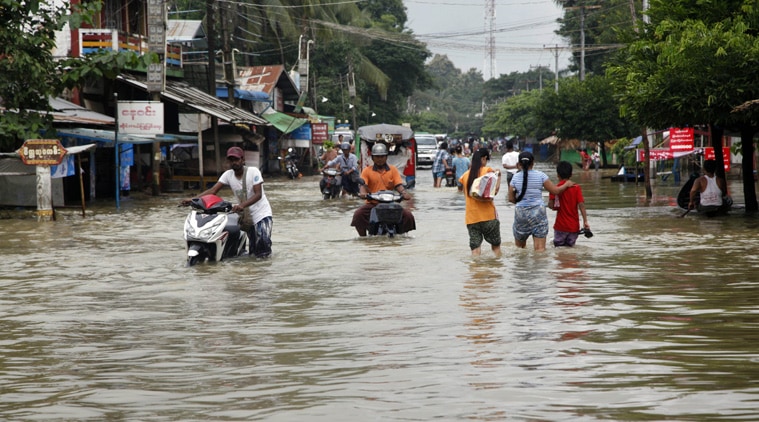
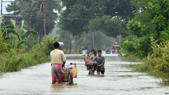
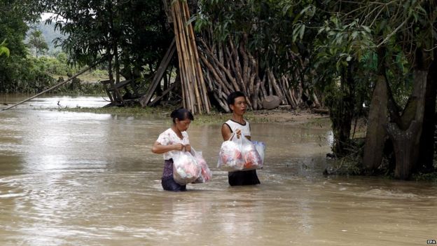
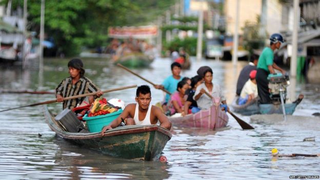
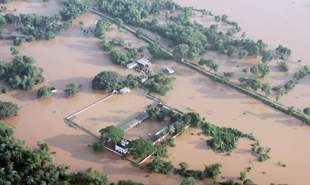
Myanmar:
3 August, 2015
2 June, 2014
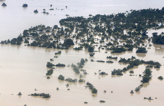
An aerial view photograph shows the roofs of flooded buildings in Kale township of Sagaing Region, Myanmar, August 2, 2015. Lynn Bo Bo/EPA. Source: rappler.com
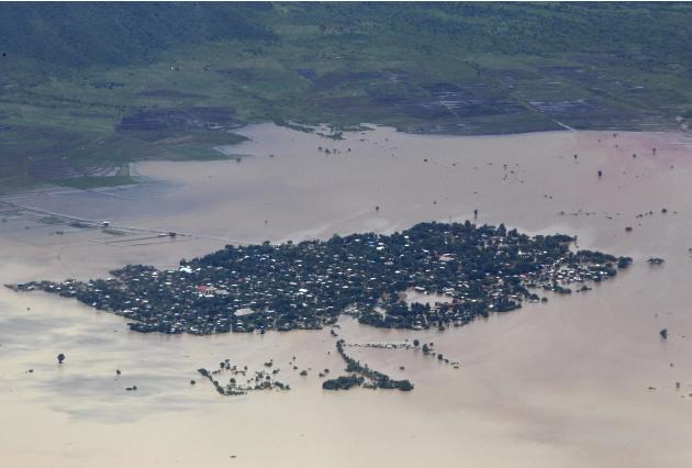
An aerial view of a flooded village in Kalay township at Sagaing division, August 2, 2015. Storms and floods have so far killed 21 people, with water levels as high as 2.5 metres in Sagaing and 4.5 metres in western Rakhine state, according to the government, which on Friday declared four regions disaster zones. REUTERS/Soe Zeya Tun TPX IMAGES OF THE DAY. Source: ca.finance.yahoo.com

Villagers walk through flood waters in Myawaddy in southeastern Myanmar's Kayin state, July 31, 2015. Source: rfa.org
Local residents wade through a flooded road in Bago, 80 kilometers (50 miles) northeast of Yangon, Myanmar, Saturday, Aug 1, 2015. (Source: AP). Source: indianexpress.com

At least 20 people were killed in flash floods in several parts of Myanmar over the past week that also affected thousands of others, an official here said on Tuesday. Source: udaipurkiran.com
3 August, 2015. 'Catastrophic' floods in Myanmar hit most vulnerable, including children – UN agencies
Myanmar has suffered heavy rains, winds and flooding since Cyclone Komen made landfall in Bangladesh on 30 July, causing landslides and damage in different parts of the country, United Nations agencies have warned.
“The floods are hitting children and families who are already very vulnerable, including those living in camps in Rakhine state,” said Shalini Bahuguna, from the UN Children's Fund (UNICEF). There are 140,000 displaced children and families in Rakhine alone.
“Beyond the immediate impact, the floods will have a longer term impact on the livelihoods of these families,” she warned.
According to the Myanmar Government, 39 people have died and over 200,000 people across the country are in need of lifesaving assistance. Twelve out of Myanmar's 14 states and regions have been affected by the rains. On 31 July, President U Thein Sein issued a statement declaring natural disaster zones in four regions, including Rakhine, where access is limited due to flooding, road blockages and landslides.
“Initial reports indicate that there is extensive damage to shelters and other infrastructure in camps around Sittwe [Rakhine's capital], where some 100,000 displaced people are staying,” stressed the UN Office for the Coordination for Humanitarian Affairs (OCHA) in an update from 30 July. Source: un.org
3 August, 2015. Myanmar rescuers race to flood zones, 46 dead
Rescue workers in Myanmar raced on Monday (Aug 3) to help tens of thousands of people in remote areas enduring roof-top high floods, as the death toll climbed to at least 46.
Relentless monsoon rains have triggered flash floods and landslides, destroying thousands of houses, farmland, bridges and roads - with fast-flowing waters hampering relief efforts.
Hundreds have also perished in recent days in India, Nepal, Pakistan and Vietnam following floods and landslides triggered by heavy seasonal rains.
In Myanmar, "46 people have died and more than 200,000 have been affected by the floods across the country", an official at the Relief and Resettlement Department told AFP.
"We are speeding up assistance and relief work," said the official, who asked not to be named.
Myanmar is a vast and poor country, where communications and infrastructure are already weak, prompting the United Nations to warn that a full picture of the scale of the disaster may not emerge for days.
Authorities have declared the four worst-hit areas in central and western Myanmar "national disaster-affected regions".
In the impoverished northern Sagaing Region, residents said the flood waters caught them off guard as they swept into villages, swamping homes and fields.
"There was no warning; we thought it was normal seasonal flooding," Aye Myat Su, 30, told AFP from a monastery being used as a temporary shelter in the regional capital of Kalay.
"But within a few hours, the whole house was underwater. My husband had to get onto the roof as there was no way out.". Source: channelnewsasia.com
2 August, 2015. Myanmar floods worst in decades
A state of emergency has been declared in several regions of Myanmar after the worst flooding in decades.
Tens of thousands of homes have been destroyed.
The country's president has visited people living in temporary shelters and the army is leading relief efforts. Source: bbc.comPakistan:
3 August, 2015 (lance-modis.eosdis.nasa.gov)
5 May, 2015
A sign board in Sindhi language reads the name of Village Muhammad Hasan in the delta region of River Indus in southern Pakistan. After the submersion of the village, the residents have moved.Many villages in the Indus delta came under water due to the sea level rise. Photo by Amar Guriro/News Lens Pakistan. Source: upi.com

Pakistani villagers wade through floodwaters caused by heavy rains at a village on the outskirts of Nowshera near Peshawar, Pakistan, Sunday, Aug. 2, 2015. (AP/Muhammad Sajjad). Source: ctvnews.ca
6 July, 2015. Encroaching sea levels endanger Pakistan's Indus Delta

Shah Murad, a fisherman in Sajan Wari village in the delta region of River Indus in southern Pakistan, said the ancestral village where he grew up was submerged by seawater. Photo by Amar Guriro/News Lens Pakistan
From its start in the Himalayas, the Indus River flows almost 2,000 miles to the Arabian Sea, ensuring there is fertile land for farmers along the way and sustenance for Pakistan's wildlife.
The river is in trouble, though. Its 17 major creeks, which in the past helped push seawater back, have almost dried up, allowing the Arabian Sea to flow upstream, poisoning the Indus River Delta with salt water and fouling farmland.
Meanwhile, sea levels are rising, swamping entire villages along the river and threatening a way of life for thousands of families.
"There were many villages in our area, which are now completely submerged and the residents had moved somewhere else," said Shah Murad, a fisherman in Sajan Wari, who lost his ancestral village four years ago to the rising waters.
Once the fifth-largest in the world, the Indus River delta stretches 130 miles inland and covers 16,000 square miles, according to WWF-Pakistan.
According to the 1929 gazette of the Indian government, which quoted a survey by the Indian Botanical Society, the Indus River Delta in the 1920s was equal to the Sundarbans, another important South Asian delta located in Bangladesh, in terms of area, variety of trees, diversity of fauna and flora and general ecosystem.
Since the 1940s, however, the Indus has changed dramatically, according to the Sindh provincial government's 2011 gazette, dropping in volume by more than half.

Commercial fishing vessels are anchored at Sajan Wari village in the River Indus delta in southern Pakistan. Some 10 years ago, this huge channel was part of River Indus, but is now filled with seawater. Photo by Amar Guriro/News Lens Pakistan
The delta has been especially hard hit, with researchers projecting it is only about 10 percent of its original size.
Satellite images from between 1979 and 2015, collected by the Pakistan Space and Upper Atmosphere Research Commission, clearly show that "a vast area in the Indus Delta has been engulfed by sea," said Solangi Sarfraz Hussain, a professor at the Center for Pure and Applied Geology at the University of Sindh.
The Pakistan Fisherfolk Forum, which advocates for Pakistani fishing communities, said much of that loss in recent years has been due to rising seas. It found that 2 million acres of fertile land has been inundated with seawater, forcing 800,000 residents of Indus Delta to migrate.
Local residents say that until the early 1970s, the area was famous for bananas, red rice, sugarcane and wheat. Most of these farmers, however, have abandoned their fields and switched to fishing.
"Since the river water reduced, and seawater submerged vast areas, the lands became saline, which destroyed agriculture. We have no other option than to switch to fishing," said Subhan Bakhsh, a fisherman of Sajan Wari, whose father was once a famous grower in the area.
The government has responded to the rising seas with a proposal to build a series of levees to protect the remaining river communities. Local residents, however, say this does not solve the problem or help those already harmed by the seas.
"Levees are not a permanent solution to this problem. We need to restore River Indus," said Muhammad Ali Shah, who heads the Pakistan Fisherfolk Forum. Source: upi.com
3 August, 2015. Monsoon floods kill 118 in Pakistan, thousands evacuated
The death toll from flash floods triggered by seasonal monsoon rains in various parts of Pakistan has risen to 118 and floodwater has inundated vast areas, leaving tens of thousands homeless, authorities said Monday.
The National Disaster Management Authority said the flooding has affected more than 800,000 people in 2,275 villages. About 2,900 houses have collapsed or are partially damaged.
The northwestern Khyber Pakhtunkhwa province is the worst affected, with 59 deaths reported there, according to NDMA's statement. The Pakistani part of Kashmir and southern part of eastern Punjab province each reported 22 deaths. Source: ctvnews.ca
-
-
India

Villagers paddle a small boat through floodwaters in Bherampur Block, Murshidabad District, some 220kms north of Kolkata as the remnants of Cyclone Komen carrying heavy monsoon rains cross the eastern Indian state of West Bengal. (AFP PHOTO). Source: hindustantimes.com
 A cyclone struck the state of West Bengal, killing 48 people in flood-related incidents. Source: bbc.com
More than 100 killed in India floods. Source: thedailybangladesh.com
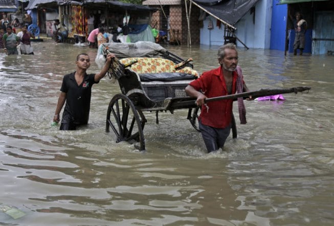
An Indian hand rickshaw puller makes his way through a flooded street in Kolkata. (Source: AP). Source: indianexpress.com
Children use big cooking pots as floats in a flooded area in Murshidabad district of West Bengal on Sunday. (Source: PTI) Source: indianexpress.com
3 August, 2015. Floods kill at least 160 across India, situation grim in Bengal
Flooding has brought chaos to several Indian states killing at least 160 people and affecting lakhs after heavy rainfall lashed West Bengal, Odisha, Manipur, Rajasthan and Gujarat, officials said on Monday.
The death toll could rise as many people are still missing even as personnel of the Indian Army are out in several areas for rescue and relief efforts, officials added.
The situation remained grim in West Bengal's southern districts after fresh water was released from different barrages, compounding the woes of over 37 lakh people in 12 affected districts.
"Flood situation in the state still remains a matter of concern after fresh water was released from different barrages since last (Sunday) night. High tides worsened the situation," state irrigation minister Rajib Banerjee told PTI.
Among others, the Damodar Valley Corporation (DVC) has released 90,000 cusecs of water since midnight on Sunday, the minister added.
The death toll due to the floods remained at 48 while 2.14 lakh people were sheltered in 1,537 relief camps in the 12 districts. According to the disaster management department's report, 47 municipalities across the state have been affected by floods.
West Bengal chief minister Mamata Banerjee, who stayed at state secretariat Nabanna overnight to personally monitor the flood situation, would visit Habra and Ashoknagar areas of North 24 Parganas to monitor the relief and rescue operations. Besides, Banerjee four of her cabinet ministers would also visit other affected districts to review the situation.
The government has issued an appeal to all the affected in the districts to move to their nearest relief camp before the situation worsens. Source: hindustantimes.com
3 August, 2015. 81 Dead, 80 (8 million) Lakh Affected In Floods In Gujarat, Rajasthan, West Bengal And Odisha
At least 81 people died and more than 80 lakh people were affected in fresh floods due to excessive rains in worst affected Gujarat, Rajasthan, West Bengal and Odisha.
In Gujarat, 14 districts and population of about 40 lakh were affected in recent floods due to heavy rainfall in the last few days. More than 10 lakh food packets have been airdropped or distributed to the flood victims, an official statement said here today.
Temporary relief camps have been set up in affected areas and peoples are accommodated on need basis. A total of 17 National Disaster Response Force (NDRF) teams have been deployed for rescue and relief operations in Gujarat. In Rajasthan, so far 28 people have lost their lives, out of which 12 people died during past few days owing to very heavy rainfall and flood like situation in many parts of the state.
Rajasthan has experienced excessive rainfall in most of its districts. The situation is grim particularly in districts of Jalore, Jhalawar, Baran, Sirohi, Barmer and Dungarpur. Apart from State Disaster Response Force, Police, RAC etc., at present eight teams of NDRF were deployed for rescue and relief operations. Source: huffingtonpost.in
3 August, 2015. Floods in West Bengal: CM Mamata Banerjee says situation ‘beyond control’
While dark clouds hovered over the state and intermittent rains lashed different areas, the authorities’ immediate worry was heavy discharge of water from reservoirs, both in Bengal and Jharkhand.
The Durgapur barrage in Bengal was scheduled to release about 65,000 cusecs of water on Sunday, with authorities warning that the release may go up to 90,000 cusecs.
There were scores of other dams releasing water simultaneously like Tilpara, Hinglo, Kangshabati, Massanjore, Maithon and Galudi in Jharkhand. The rivers in these areas like Subarnerekha , Kangshabati, Damodar were swollen and the reservoirs full.
Chief Minister Mamata Banerjee, who had often described floods during the Left regime as “man made” because it was caused largely due to release of water from dams, regretted that her government was watching vast areas getting submerged as water was being released from dams.Speaking to mediapersons at Nabanna on Sunday, Mamata said: “In the last four years, there has been no flood like this. So far, we have witnessed man-made floods and we have restricted them quite successfully. But the situation at present is rendered beyond control.” Source: indianexpress.com
29 July, 2015. Millions at risk from rapid sea rise in swampy Sundarbans

Seas are rising more than twice as fast as the global average here in the Sundarbans
The tiny hut sculpted out of mud at the edge of the sea is barely large enough for Bokul Mondol and his family to lie down. The water has taken everything else from them, and one day it almost certainly will take this, too.
Saltwater long ago engulfed the 5 acres where Mondol once grew rice and tended fish ponds, as his ancestors had on Bali Island for some 200 years. His thatch-covered hut, built on public land, is the fifth he has had to build in the last five years as the sea creeps in.
Tens of thousands like Mondol have already been left homeless, and scientists predict much of the Sundarbans could be underwater in 15 to 25 years."Every year we have to move a little further inland," he said.
Seas are rising more than twice as fast as the global average here in the Sundarbans, a low-lying delta region of about 200 islands in the Bay of Bengal where some 13 million impoverished Indians and Bangladeshis live.

In this February 1, 2015 photo, villagers help a fisherman couple push their boat to the water at Satyanarayanpur village in the Sundarbans, India. Photo: AP
That could force a singularly massive exodus of millions of "climate refugees," creating enormous challenges for India and Bangladesh that neither country has prepared for.
"This big-time climate migration is looming on the horizon," said Tapas Paul, a New Delhi-based environmental specialist with the World Bank, which is spending hundreds of millions of dollars assessing and preparing a plan for the Sundarbans region.
"If all the people of the Sundarbans have to migrate, this would be the largest-ever migration in the history of mankind," Paul said. The largest to date occurred during the India-Pakistan partition in 1947, when 10 million people or more migrated from one country to the other.
Mondol has no idea where he would go. His family of six is now entirely dependent on neighbors who have not lost their land. Some days they simply don't eat.

In this January 31, 2015 photo, a bird sits on a tree near a newly built embankment at Bijoynagar village in the Sundarbans, India. Photo: AP
"For 10 years I was fighting with the sea, until finally everything was gone," he says, staring blankly at the water lapping at the muddy coast. "We live in constant fear of flooding. If the island is lost, we will all die."
On their own, the Sundarbans' impoverished residents have little chance of moving before catastrophe hits. Facing constant threats from roving tigers and crocodiles, deadly swarms of giant honeybees and poisonous snakes, they struggle to eke out a living by farming, shrimping, fishing and collecting honey from the forests.
Each year, with crude tools and bare hands, they build mud embankments to keep saltwater and wild animals from invading their crops. And each year swollen rivers, monsoon rains and floods wash many of those banks and mud-packed homes back into the sea.
Most struggle on far less than $1 a day. With 5 million people on the Indian side and 8 million in Bangladesh, the Sundarbans population is far greater than any of the small island nations that also face dire threats from rising sea levels.
Losing the 26,000-square-kilometer (10,000-square-mile) region - an area about the size of Haiti - would also take an environmental toll. The Sundarbans region is teeming with wildlife, including the world's only population of mangrove forest tigers. The freshwater swamps and their tangles of mangrove forests act as a natural buffer protecting India's West Bengal state and Bangladesh from cyclones.
With rising temperatures melting polar ice and expanding oceans, seas have been rising globally at an average rate of about 3 millimeters a year - a rate scientists say is likely to speed up. The latest projections suggest seas could rise on average up to about 1 meter (3.3 feet) this century.
That would be bad enough for the Sundarbans, where the highest point is around 3 meters (9.8 feet) and the mean elevation is less than a meter above sea level. But sea rise occurs unevenly across the globe because of factors like wind, ocean currents, tectonic shift and variations in the Earth's gravitational pull. The rate of sea rise in the Sundarbans has been measured at twice the global rate or even higher.
In addition, dams and irrigation systems upstream are trapping sediments that could have built up the river deltas that make up the Sundarbans. Other human activities such as deforestation encourage erosion.
A 2013 study by the Zoological Society of London measured the Sundarbans coastline retreating at about 200 meters (650 feet) a year. The Geological Survey of India says at least 210 square kilometers (81 square miles) of coastline on the Indian side has eroded in the last few decades. At least four islands are underwater and dozens of others have been abandoned due to sea rise and erosion.
Many scientists believe the only long-term solution is for most of the Sundarbans population to leave. That may be not only necessary but environmentally beneficial, giving shorn mangrove forests a chance to regrow and capture river sediment in their tangled, saltwater-tolerant roots.
"The chance of a mass migration, to my mind, is actually pretty high. India is not recognizing it for whatever reason," said Anurag Danda, who leads the World Wildlife Fund's climate change adaptation program in the Sundarbans. "It's a crisis waiting to happen. We are just one event away from seeing large-scale displacement and turning a large number of people into destitutes."
West Bengal is no stranger to mass migration. Kolkata, its capital, has been overrun three times by panicked masses fleeing violence or starvation: during a 1943 famine, the 1947 partition and the 1971 war that created today's Bangladesh.
India, however, has no official plan either to help relocate Sundarbans residents or to protect the region from further ecological decline.
"We need international help. We need national help. We need the help of the people all over the world. We are very late" in addressing the problem, said West Bengal state's minister for emergencies and disaster management, Janab Javed Ahmed Khan. He said West Bengal must work urgently with the Indian and Bangladeshi governments to take action.
Bangladesh is supporting scientists "trying to find out whether it's possible to protect the Sundarbans," said Taibur Rahman, of the Bangladesh government's planning commission. "But we are already experiencing the effects of climate change. The people of the Sundarbans are resilient and have long lived with hardship, but many now are leaving. And we are not yet prepared."
A network of concrete dykes and barriers, like those protecting the Netherlands, offers limited protection to some of the islands in Bangladesh's portion of the Sundarbans. The World Bank is now spending some $200 million to improve those barriers.
Experts worry that politicians will ignore the problem or continue to make traditional promises to build roads, schools and hospital clinics. This could entice more people to the region just when everyone should be moving out.
"We have 15 years ... that's the rough time frame I give for sea level rise to become very difficult and population pressure to become almost unmanageable," said Jayanta Bandopadhyay, an engineer and science professor at Jawaharlal Nehru University in New Delhi who has studied the region for years.
Bandopadhyay and other experts say India and Bangladesh should be creating jobs, offering skills training, freeing lands and making urbanization attractive so people will feel empowered to leave.
Even if India musters that kind of political will, planning and funds, persuading people to move will not be easy.
Most families have been living here since the early 1800s, when the British East India Company - which then governed India, Pakistan and Bangladesh for the British Empire - removed huge mangrove forests to allow people to live on and profit from the fertile agricultural land.
Even those who are aware of the threat of rising seas don't want to leave.
"You cannot fight with water," said Sorojit Majhi, a 36-year-old father of four young girls living in a hut crouched behind a crumbling mud embankment. Majhi's ancestral land has also been swallowed by the sea. He admits he's sometimes angry, other times depressed.
"We are scared, but where can we go?" he said. "We cannot fly away like a bird." Source: dhakatribune.com
2 August, 2015. Saline water invasion looms large for AP capital city
Amaravati, the proposed mega capital city of Andhra Pradesh, is now facing the threat of sea water intrusion. Already sea water has intruded into the groundwater table up to the outskirts of Vijayawada and Guntur cities, and experts warn that there will be further ingress in the future. The groundwater table in the entire area between Vijayawada and Guntur, where the state capital has been planned, will turn salty if immediate remedial measures were not initiated.
The sea water ingress has been recorded in areas as far away as 58 km from the coastline in Krishna district. In case of Guntur district, the sea water has made inroads up to 50 km through underground channels. Experts attribute the sea water ingress to over-exploitation of the groundwater table and poor monsoon over the years.
"Amaravati, Vijayawada and Guntur together will put further pressure on the groundwater table as the population is likely to increase significantly once the administrative capital is ready. Monsoon has been playing truant in the last two decades. Failure of monsoon and over-exploitation of the groundwater will lead to further ingress of the sea. Already the sea water has entered Kankipadu, which is hardly 10 km away from the proposed capital," warns Prof KSR Prasad of the department of civil engineering, VR Siddhartha Engineering College, Vijayawada.
Prof Prasad along with Prof TS Ramaiah Chowdary has analysed about 50 water samples collected from various villages in Krishna delta. The analysis revealed that there is severe fresh water crisis in the delta. The problem is felt more in Krishna district than in Guntur district. The result of the study was published in the recent issue of the International Journal of Engineering Technology, Management and Applied Sciences.
He said about 75 percent of the population in Krishna delta depend on groundwater for domestic, industrial and agricultural needs. The pressure on groundwater will go up tremendously once Amaravati city takes the final shape. "The current annual groundwater draft in Krishna Eastern delta is 115.60 million cubic metre and 99.50 MCM in Krishna Western delta. Over the years the transformation of fresh groundwater to saline water is taking place in the delta at a faster rate due to intensive increase of sea water intrusion," the study pointed out.
Prasad told TOI that the groundwater has become highly saline in places like Kaza, which is 20 km away from the sea. Even Thadanki which is 41 km from the sea coast is experiencing salinity. What is worrying is that Kankipadu in Vijayawada, which is 58 km from the sea, has also been affected. This is evident from the presence of concentrations of chlorides and total dissolved solids in Kankipadu.
The survey revealed that there is excess exploitation of water from bore wells to meet the agricultural demand. The chloride content in the groundwater varied from 123 mg/l to 6029 mg/l in Krishna district and 98.31 mg/l to 1346 mg/l in Guntur district.
The researchers suggested measures like artificial recharge, reduced use of groundwater and restriction on use of chemical pesticides and fertilisers to check salinity of groundwater and prevent ingress of sea water. Source: timesofindia.indiatimes.com
Vietnam:

A seriously submerged area in Thanh Son Ward, Uong Bi City, the northern province of Quang Ninh. Source: tuoitrenews.vn
3 August, 2015. Floods kill 22 in Vietnam
Twenty-two people have been killed in a week of record floods in northern Vietnam, authorities said Monday, warning that more rains and floods would hit the area in the coming days.
Among the dead were 17 victims from Quang Ninh province, the Central Committee for Flood and Storm Control said.
The province has received more than 800 millimetres of rain in the past seven days, the most in the past 40 years.
Nearly 2,500 hectares of rice were submerged while more than 11,500 head of cattle and poultry were killed.
Total damage was estimated at about 100 million dollars, of which Vietnam National Coal and Mineral Industries Group lost 57 million dollars, the authorities said.
Electricity of Vietnam has warned of a possible shortage of power, as coal mining and transportation have been halted due to torrential rains and floods, the Viet Nam News reported. Source: nationmultimedia.com
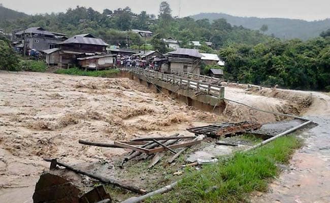
Nepal:
 At least 90 people have been killed across Nepal in the past two months due to floods and landslides triggered by heavy rains, authorities have said. Source: ibnlive.com
3 August, 2015. In Nepal, floods, landslides kill 90 in two months
At least 90 people have been killed across Nepal in the past two months due to floods and landslides triggered by heavy rains, authorities have said.
Representational photo-Image courtesy-ReutersRepresentational photo-Image courtesy-Reuters
According to a report presented in the Parliament, 117 houses, four bridges, five suspension bridges and one school have been destroyed in the various natural calamities.
At least 90 people have been killed in the recent monsoon-induced natural disasters, the report said.
Presenting the report in Parliament, Deputy Prime Minister and Home Minister Bam Dev Gautam said the most loss of human lives and property occurred in the landslides in Taplejung and Kaski district. Source: firstpost.com
-
-
Myanmar
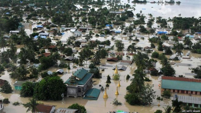
Sagaing is one of four districts in Myanmar to be declared a disaster zone by the government. Source: bbc.com

An aerial view shows flooding in Kalay, a town in north-west Myanmar. The toll from flash floods and landslides in Myanmar after days of torrential rain is likely to spike, the UN warned. Ye Aung Thu / AFP Photo. Source: thenational.ae
 Flood victims have been receiving supplies from local aid groups. Source: bbc.com
Villagers walk through flood waters in Myawaddy in southeastern Myanmar's Kayin state, July 31, 2015. Source: rfa.org
Many in Myanmar said the rains are the worst in many years. Source: bbc.com
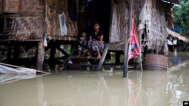
A woman and her child look out from their residence half-submerged in floodwaters in Bago, 80 kilometers northeast of Yangon, Myanmar, Saturday, Aug 1, 2015. Source: voanews.com
Source: ReliefWeb in pdf
2 August, 2015. Myanmar floods leave at least 47 dead
WEEKS of heavy rain in Myanmar have left at least 47 people dead and damaged farmland, government officials and media report.
MORE than 212,000 hectares of farmland in 12 out of 15 states and divisions across the country were seriously affected by floods as the heavy rain continues, the Ministry of Agriculture and said.
Floods and landslides destroyed more than 20,000 homes and affected some 200,000 people in the Sagaing and Mandalay regions as well as in the Kachin and Shan states, local media reported.
Ko Ko Kyaw of the Myanmar Red Cross Society estimates the death toll is much higher.
"Almost all parts of the country were facing the flood," he said.
The UN's Office for the Co-ordination of Humanitarian Affairs (OCHA) has also warned the death toll is expected to be rise.
Myanmar's government has been criticised for a slow and inadequate response. Source: theaustralian.com.auIndia

The MeT department recorded 143.2 mm rainfall in the last 24 hours till 5.30 pm today and has forecast heavy to very heavy rains in Gangetic West Bengal for another two days. (Photo: PTI). Source: deccanchronicle.com

Floods inundate village in West Bengal in India, at least 25 dead, Al-Alam News Network reports. Source: en.alalam.ir
Crucial bridges in Chandel have been damaged, which is hampering rescue operations. Source: ndtv.com
More than 40 killed in West Bengal; heavy rainfall in Odisha, Rajasthan and Gujarat. Source: india.com
2 August, 2015. Around 70 Die as Floods, Landslide Hit Bengal, Manipur, Odisha
The aftermath of Cyclone Komen has hit large parts of Bengal, Odisha and Manipur, causing floods and landslides in which around 70 people -- 48 of them in Bengal alone -- have died so far.
The depression has reached Gangetic West Bengal. Rain will continue but intensity likely to be less. Heavy rains have been predicted for the next 24 hours.
Incessant rain has not only sunk large parts of capital Kolkata but also 12 districts, said Chief Minister Mamata Banerjee. Five of the districts are on high alert.
Over 2 lakh people have ended up in relief camps after 1.8 lakh houses were damaged. Farmland of over 21 lakh hectare has been submerged, she said.
Manipur is suffering from what people say are the worst floods in 200 years, In which an estimated one lakh people have been affected. Source: ndtv.com
2 August, 2015. Over two million people affected by floods in West Bengal
The flood situation in south Bengal turned grim on Sunday as more than two million people in 5,600 villages across 12 districts were affected by the heavy rains.
“Several districts — including North and South 24 Parganas, Murshidabad, Burdwan and Howrah — have been severely affected. Disaster management teams are working on a war [-like] footing,” West Bengal Chief Minister Mamata Banerjee told media.
Banerjee, who is already touring districts to monitor the relief operations, added: “The situation is getting worse with every passing day as more and more areas are getting inundated. So far 966 relief camps have been set up all across the affected districts, sheltering 1.18 million affected people. As per our initial reports, 180,000 houses have been damaged and crop was lost in over 210,000 hectares [518,921 acres] due to the floods.”
“We have opened 124 medical camps and the government is working on a war footing,” the chief minister added.
The death toll crossed more than 50 after seven more deaths, including those of four children, were reported from various districts. Buildings with weak structures collapsed in several areas, including in the city, due to the overnight downpour.
Source: gulfnews.com

1 August, 2015. 45 dead as West Bengal fights the worst floods after many years
Kolkata: Severe rain lashed southern Bengal throughout Friday night and the whole of Saturday as cyclone ‘Komen’ made landfall in Bangladesh, and weakened into a depression and progressed inland.
Until now, 45 people have died and over 700,000 people have been left homeless as several districts of the state are reeling under the worst floods that the state has faced in several years. Source: gulfnews.com
Pakistan
2 August, 2015
6 June, 2015

Pakistan Navy team rescuing the flood affectees at various areas of district Khairpur, Ghutki , Sukkar , Larkana, Rani pur , and Pannu Aqil on August 1, 2015. PHOTO: PAK NAVY. Source: tribune.com.pk
2 August, 2015. Floods kill more than 100 in Pakistan
THE death toll from three weeks of flooding in Pakistan has surpassed the 100 mark.
FLASH floods killed 109 people and some 700,000 have been affected, the National Disaster Management Authority said on Sunday.
Military engineers repaired roads and bridges in the mountainous north to help rescuers reach people cut off for weeks, the authority said.
River Indus, which flows down from the Himalayas to the Arabian Sea, flooded at several points in southern Sindh province, meteorological department chief Ghulam Rasool said.
More rain is expected, Rasool said.
Around 350,000 people have been evacuated from the banks of the Indus in past two days. Source: news.com.auVietnam

People search at a landslide site caused by violent floods in Ha Long city, northern province of Quang Ninh on July 28. Photo by Vietnam News Agency/AFP
28 July, 2015, Flooding near Vietnam's Halong Bay kills at least 14
At least 14 people have been killed in the worst flooding for 40 years in Vietnam's northern Quang Ninh province, home to the UNESCO-listed Halong Bay tourist site, officials said Tuesday, July 28.
Three more people were missing and a number of local tourists remained stranded on nearby Co To island, which is cut off from the mainland due to torrential rain, according to a local disaster relief official.
"We have no information on any foreign tourists that may have been stuck in affected areas," the official said, speaking on condition of anonymity.
Of the 14 dead, a woman and two children were discovered drowned in a flooded house, he told Agence France-Presse, with many residential areas in Halong City still under water after the province was hit by more than 500 millimetres (20 inches) of rain on Sunday alone.
Thousands of soldiers have been mobilized to help local residents evacuate flooded areas as well as districts hit by landslides trigged by the rains, Quang Ninh province's official website said.
The recent torrential downpour has been the heaviest and caused the worst flooding in more than 40 years, it said. Source: rappler.com
-
Comment by Khan on July 27, 2015 at 9:06am
-
Banglades: Tidal surge, heavy rains trigger flooding in coastal areas
July 27, 2015
A road submerged by rainwater in Maijdee Court area of Noakhali yesterday. INDEPENDENT PHOTOTorrential rains, onrush of water from upstream and high tide have inundated vast areas in coastal districts, leaving tens of thousands of people marooned.
The normal life in Bhola district has been disrupted due to flooding of homesteads over the past one week.
Sources said the rain that started a week ago has been continuing till yesterday. As a result, the water level of the River Meghna has risen inundating the low laying areas, including the Char (shoal) lands located on both the sides of the river. Majher Char and Rajapur Char of Bhola sadar, Medua Madanpur and Hajipur union of Daulatkhan upazila, Char Johir Uddin of Tajumuddin upazila and Dhal Char, Char Patila and Chars of Monpuyra upazila go under water during tide every day.
On the other hand, erosion has taken a serious turn devouring new areas in the district.
Following the week long torrential rains standing crops on a vast tract of lands, especially the char areas of the district were inundated.
The low-laying areas in Bhola town have been gone under water due to the heavy showers.
Thousands of fishermen and low-income people, including day labourers, are spending idle time. The fishermen cannot sail into the turbulent sea for catching fish and day labourers are not called for work for continuous rain.
Sources in the agriculture department said it is the time for sowing Aman seeds and preparing lands for transplantation of seedlings, but it is being hampered seriously due to the water logging and rain.
Our correspondent from Nokahlai reports: The low-lying areas in Fulgazi and Parshurm upazilas in Feni town have gone under water and shoal areas in Subarnachar, Hatiya have been inundated by torrential rains and tidal surge, caused by a depression in the Bay of Bengal.
Mohari River in Uttar Dulatpur of Fulgazi upazila continued to flow 80 to 85 cm above the danger level on Saturday.
Hundreds of people have been marooned, fish enclosures and standing crops damaged by water during the last 24 hours.
Sources said rain water has inundated Shahid ullah kaser roads, Lalpur, Fetepur, Mohipal areas in Feni district. Local newsman of Feni Bokthier Islam Munna said water has entered his house on Friday night.
Nirbhai Officer of Fulgazi upazila Mahidur Rahman said flood control embankment of Mohari River has collapsed at two places in Shapur and uttar Daulatpur villages due to heavy down pour.
Nearly 4,000 families have shifted to safer places, the UNO said. The upazila administration has distributed dry food among the affected people, he said.
UNO Hatiya Abu Hasnat Md Mohin Uddin quoting chairmen of respective unions said the tidal waters entered vast areas through the breaches of the flood control embankment at Naler char point. As a result, shrimp in the enclosures, fish in the ponds have been washed away.
-
-
Sea wall along coastal road could lead to more floods in Mumbai.
July 27, 2015
Experts say it will stop channels of water entering the sea and cause flooding.
If there is one thing the Brihanmumbai Municipal Corporation (BMC) has consistently shown when it comes to providing civic amenities and infrastructure congruous with the environment, it is that it never learns to do so.
While Sunday marked the completion of 10 years since the 26/7 Mumbai floods, it has now come to light that two of the BMC’s most ambitious plans Development Plan (DP) and coastal road will not do anything to prevent flooding in the city.
While the DP makes no specific provisions to arrest flooding, a sea wall to be constructed for the coastal road may actually cause more flooding, since it will stop channels of water entering the sea.
Wall of problems
Well-known architect P K Das has criticised the DP as well as the coastal road in public forums. He said, “A sea wall has been envisaged along parts of the coastal road. But construction of such walls is banned in the US and Europe.Officials’ assumption that it will prevent storm surges is archaic. It will in fact lead to flooding, since the wall will prevent floodwater entering the sea. If a natural drainage channel underground is severed, it will result in a counter action and cause flooding in the city.”
Environmentalist Rishi Agarwal also said that it was possible that the sea wall might lead to what retaining walls along some of Mumbai’s rivers led to. “Retaining walls were built for Dahisar, Poisar, Mithi rivers, which actually caused rain water to head towards the land. So I am unsure of the impact of the sea wall on flooding.”
Road to troubles
Hussain Indorewala, assistant professor at Kamla Raheja Vidyanidhi Institute for Architecture, who has been studying the coastal road project, said, “The 2005 floods were mainly caused because of the intensity of rain, which was 125 mm/hour while our drainage systems are equipped to handle only 25 mm/hour.The recent June 19 rains had an intensity of only 38 mm/hour and, even then, there was flooding. This means 26/7 may happen again. Besides, the coastal road will destroy mangroves which act as a natural absorption channel for flood water, on a large scale.”
According to Indorewala, the coastal road will further reduce the width of the Juhu nullah and Malad creek. “Mangroves near the Malad creek will be destroyed for the road to be constructed there. This means all areas adjacent to the Malad creek (upstream) will be flooded during monsoons,” he said.
The coastal road’s environment impact assessment report states that mangroves should not be destroyed. Raghavanand Haridas, an architect from Santacruz, also criticised the coastal road for its tremendous costs to the public exchequer. “In the erstwhile development plans, a ring road was proposed between Bandra and Borivli.
Why can’t that concept be developed? Why do we need the coastal road at all?” Today (July 27) is the last date for submitting suggestions and objections for the coastal road. The civic body has received around 60 of them so far. The draft development plan released by the civic body in February, also makes no separate provisions to prevent flooding.
Only broad outline
“We have made provisions for additional pumping stations in the DP. Besides, the Development Control Regulations (DCR) stipulate certain things such as distance of a building from a nullah and plinth height. But no other provision was made.After all, the DP only gives a broad outline for the city. The specific departments should deliberate on this,” said V K Phatak, consultant to the BMC for the original draft DP. The DP is now being revised and suggestions/ objections are supposed to be incorporated.
-
-
Pakistan: Old problems, unresolved- Floods in Bhudni nullah leave locals stranded
July 27, 2015
People stranded and traffic suspended in Bhudni Pul area. PHOTOS: MUHAMMAD IQBAL/EXPRESS
“Residents in Usmania Colony on Warsak Road have placed sand-filled bags on the sides of the nullah to protect houses from flooding,” said a local government councillor, Manzoor Ali. Four days ago on Thursday, the same colony had flooded with waste when garbage and rainwater mixed and seeped into houses and shops. However, the problem repeated itself on Sunday when the nullah flooded.
Some residents also took shelter on roofs. Standing water caused traffic to suspend on Peshawar-Charsadda Road, disconnecting parts of the district.
According to DC Riaz Mehsud, the district government diverted traffic from the route, and asked transporters to use the Peshawar-Islamabad Motorway instead to go to Charsadda. Ambulances were also deployed in vulnerable areas.
Rescue efforts and encroachment
Rescue 1122 teams have so far helped 40 people evacuate houses. The teams faced difficulties in evacuating the residents as encroachments blocked their access. Some people were also reluctant to leave their houses despite the flooding.
When contacted, Rescue 1122 Spokesperson Bilal Faizi said the teams included divers who were on the run—visiting flooded houses in rescue boats—to ensure timely evacuation and avoid loss of life.
Faizi added mostly children and older adults were the ones stranded
Minister for Information Mushtaq Ghani also visited Bhudni Pul and monitored the situation. He directed the district government, police, Provincial Disaster Management Authority (PDMA) and Rescue 1122 to forcibly evacuate people even if they refuse so that loss of life can be avoided.
-
-
India: Over 4,500 people died in floods in last 4 years
23 Jul, 2015
NEW DELHI: Over 4,500 people lost their lives in floods in the last four years and nearly 26,500 villages were affected, which were washed away either partially or fully, the government today said.
Replying to a question in Lok Sabha, Minister of State for Water Resources Sanwar Lal Jat said that according to Home Affairs Ministry, 26,449 villages were affected by floods during the last three years and current year till July 19.
This includes the villages washed away partially or fully, he added.
As per statewise data on the number of lives lost due to the floods in the last three years, a total of 4,553 people were killed, with Uttarakhand topping the list with 800.
The total damages to crops, public utilities and houses during the last three years is estimated at Rs. 40,60,758 crores, the data revealed.
-
-
Jamaica
3 July, 2015. Sea Floods Rocky Point Community

Residents in Rocky Point, Clarendon, are now on edge as water from the sea has flooded the community.
This morning residents woke up to flooded streets and yards as high tides caused huge volumes of water to flood the entire Shearer Heights area. One resident, who gave her name as Pedro, said the water started flooding houses sometime around 1 a.m. when it was extremely windy.
"A lot of people house flood out and nobody cannot leave them premises and go anywhere, you can’t get nowhere to walk. People furniture and appliances get damaged by the sea water. We are scared man, we can’t come out," she told The Gleaner.
She said the drains are flooded and the situation is getting worse each day.
The affected residents said they have been experiencing the effects of this high tide for the last six weeks and fisher folk have been unable to venture out to sea.
However, one fisherman is feared lost at sea after he braved the weather and went out last night.
Another boat left in search of him at daybreak. Fishing equipment including huts and boats have also been damaged as a result of the strong winds.
Councillor for the Rocky Point Division, Winston Maragh, who visited the community this morning, said the main roads are inaccessible as they are flooded. He added that a senior citizen’s home and a basic school are also severely affected by the flood waters.
"Many persons have to park their vehicles in a yard on the hill and walk home, so it’s a serious problem," he said.
Maragh said based on the assessments carried out, 25 per cent of Rocky Point is currently flooded.
He has suggested a temporary solution of covering the area with river shingle and marl to give residents access to their homes.
However, he said the National Works Agency says a sea wall may be needed to solve the problem on a more long-term basis. Source: jamaica-gleaner.com
-
-
Philippines:

The barangay hall of Tinumigues in Lambayong town, Sultan Kudarat on Wednesdaay, June 24. Flashfloods brought about by continous heavy rains since Tuesday night temporarily displaced some 25,000 residents in four towns and one city in Sultan Kudarat province on Wednesday. MindaNews photo by Ferdinandh B. Cabrera
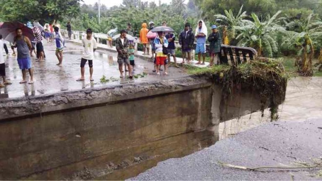
RESIDENTS of the village of Concepcion in Koronadal City find themselves cut off from the rest of the city after strong river currents swept away a portion of the village bridge. @AL SALUDO/CONTRIBUTOR

Floods in Cotabato. Source: interaksyon.com
25 June, 2015. No heavy rain, but bridge collapses, 3 dead in South Cotabato floods
Three people were killed, a major bridge was damaged and several areas of South Cotabato were submerged in flood waters following hours of light to moderate rain that started on Tuesday.
Tupi, South Cotabato Mayor Reynaldo Tamayo said separate landslides took place in Barangay Bunao and Lunen and killed three people.
Tamayo did not identify those killed but added that the landslides were triggered by the rain.
“A little rain here causes flood already,” said Sid Samaniego, municipal media relations officer.
Flooding was also reported on Tuesday in Legazpi City, Albay province. Edwin Fernandez, Inquirer Mindanao with Maricar Cinco and Michael Jaucian, Inquirer Southern Luzon. Source: newsinfo.inquirer.net
24 June, 2015. 3 die, 800 displaced in SouthCot, S. Kudarat floods
Three people have died while around 800 residents were displaced in parts of South Cotabato and Sultan Kudarat provinces as flashfloods and landslides hit the area early Wednesday.
Reports from local Disaster Risk Reduction and Management (DRRM) offices said the floods and landslides occurred following the almost non-stop heavy to moderate rains that started on Tuesday evening.
In South Cotabato, severe flooding were reported in the municipalities of Banga, Norala, Tantangan, Tupi and Koronadal City due to the swelling of several rivers and tributaries.
Landslides were also reported in Barangays Bunao and Lunen in Tupi after a portion of a mountain collapsed at the height of heavy rains early Wednesday.
In Banga town, the MDRRMO reported that some 280 families composed of 600 individuals have evacuated due to the flashfloods that affected eight barangays.
An initial 117 hectares of palay farmlands were damaged as a result of the floods in Barangays Yangco, Malaya, Cabuling, Reyes Punong Grande, Rizal, Rang-ay and Cinco.
Arman Palomar, Yangco barangay chairman, said 280 families were forced to leave their homes as early as 2 a.m. after huge volumes of floodwaters from nearby Banga River swept their area.
He said some 75 houses sustained various damages due to the floods that reached about four feet. Source: mindanews.com
India:
The Saurashtra region is the worst-hit by floods. Source: bbc.com

MI-17 V5 helicopters of Indian Air Force carrying out rescue and relief operation in Amreli district. Source: ibtimes.co.in
25 June, 2015. Floods kill 41 in western India
Flash flooding triggered by torrential rains has killed 41 people in India’s western Gujarat state, as the annual monsoon season hits the country, a disaster management official said Thursday.
Authorities have evacuated more than 10,000 residents mainly from coastal areas of Gujarat following heavy rains in the last 24 hours, the state government said in a statement.
The coastal district of Amreli was the worst affected, with 36 people killed in flood-related incidents, a duty officer in the state’s disaster control room said.
“There have been 41 deaths across the state with 36 in Amreli, three in Bhavnagar and two in Rajkot districts,” the official told AFP.
Thirteen of the deaths in Amreli occurred when two houses collapsed in the flooding, local police deputy superintendent Pinakin Parmar told AFP.
India normally sees flooding during the monsoon but the intensity of this year’s rains in Gujarat has surprised many.
The air force has been deployed to help with evacuations, including that of 44 passengers of a bus stuck on a flooded highway near Amreli town, the government’s statement said.
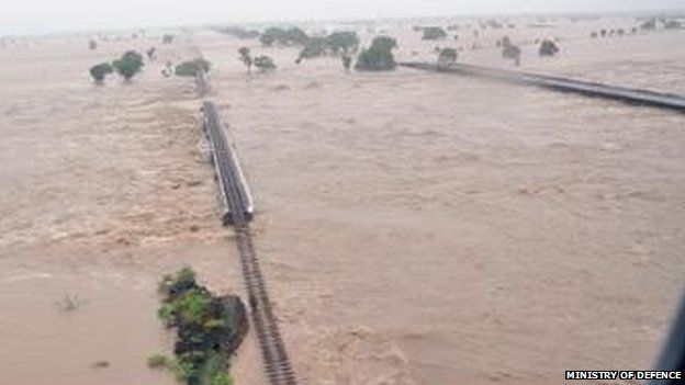
In photos released by the defence ministry, families were shown huddling on rooftops of flooded homes awaiting rescue, along with washed out train tracks and roads.
India’s weather bureau has forecast more heavy rain in Gujarat for the next two days.
As the monsoon sweeps across the country, flood warnings have also been issued in northern Jammu and Kashmir state — hit by floods last year that claimed about 300 lives.
Waters were receding in northeastern Assam following floods there last week. But more than 20,000 people were still waiting to return home after moving to higher ground after the rain hit, the Press Trust of India said.
Nearly 900 hectares (2,223 acres) of farm land was also still under water in that state, the news agency added.
The monsoon is vital for South Asia especially for crop production. India receives nearly 80 percent of its annual rainfall between June to September period. Source: tribune.com
Vietnam:

A man transporting rice cakes for sale on his bicycle, looks at his produce while standing on a flooded street in Vietnam's central ancient town of Hoi An on Nov 18, 2013. Photo: Reuters
24 June, 2015. Flash Floods Kill 7, Leave 4 Missing in Northern Vietnam
A disaster official says flash floods triggered by a tropical storm have killed seven people and left four others missing in a northern Vietnamese province.
Tran Viet Phuong in Son La province said Thursday that authorities are still searching for the four missing, including a four-year-old boy whose house was washed away.
Flash floods washed away more than 20 houses in the province, he said.
Tropical Storm Kujira which slammed northern coast on Wednesday has now dissipated, according to the national weather forecasters.
The storm has dumped up to 20 centimeters (nearly 8 inches) of rain on many parts of northern region over the past two days.
Vietnam is prone to flood s and storms, which kill hundreds of people each year. Source: todayonline.com
-
Comment by casey a on May 25, 2015 at 1:05am
-
hmm. at the bottom it say "Water data courtesy of US Bureau of Reclamation"
The bureau of reclamation website shows that the lake mead's water level lost 7 ft @ 11pm on the 23 May. Before it & After it the water levels @ Mead are at 1077 ft., though.
When the drop in Mead's elevation levels happen, there is a drop in the water release rate from Hoover dam, also. But earlier in the day, there were even bigger drops in the rate at which water was released out of Hoover; yet the water levels at Mead remained @ 1077 ft.
The funny thing is in the next hour on the 24th, water levels have gone back to the 1077ft level. Either numbers are fudged or this was some sensor malfunction.
(trying to think of how else this could have happened. Wasn't sure which way colorado river flows. So, putting this here)
© 2025 Created by 0nin2migqvl32.
Powered by
![]()
You need to be a member of Earth Changes and the Pole Shift to add comments!
Join Earth Changes and the Pole Shift