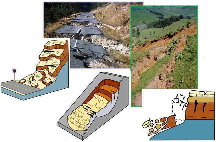
"The causes of landslides are not a mystery to mankind. Layers of rock and soil such that rain running along a clay or rock layer can create a slippery surface for the weight of the layers above it is a common cause. A rock jumble from previous mountain building, broken or fractured rock easily dislodged. We have stated that the earthquakes man experiences between the periodic passages of Planet X can be considered aftershocks from the last passage, and this is true of landslides also. Mountain building rumples the landscape, so the land is not flat but has steep ravines and hill sides. Older mountain ranges are recognized for their rounded or smoothed appearance, because of frequent landslides distributing the rubble.

"As we approach another passage, another Pole Shift, the pace of landslides has picked up. Why would this be? Plates under pressure will put pressure on regions that contain rumpled hillsides and deep ravines, as these give more readily than strictly flat land, thus act as a weak link. In addition, due to the wobble, the weather has gotten more extreme, with drought and deluge increasing in extremes. Dry ground, suddenly flooded with rainwater needing to seek its level as runoff, will create internal water slides between the rock and soil layers that constitute the rumpled hillsides. Is there an early warning system that mankind could use? The trembles that soil about to slide emits could be detected, yes. These are not earthquakes, and have their own frequency. "

ZetaTalk Chat Q&A: March 22, 2014
Views: 122425

Comment

You need to be a member of Earth Changes and the Pole Shift to add comments!

Join Earth Changes and the Pole Shift

Comment by KM on December 17, 2020 at 3:25am

https://www.cbc.ca/amp/1.5840743?fbclid=IwAR0RugK099fxxWe8ZOavF_XZi...

Landslide triggers massive debris cascade in remote part of B.C. coast

Force of event in November equivalent to a magnitude 4.9 earthquake, scientists say

Elliot Creek bed after landslide north of Campbell river
Scientists suspect a massive landslide scoured the Elliot Creek bed, creating this canyon, after an initial outflow into a glacial lake triggered an 'outburst flood.' (Bastian Fleury/49 North Helicopters)

A massive landslide on the B.C. coast about 220 kilometres northwest of Vancouver in November propelled approximately 7.7 million cubic metres of debris into an ocean inlet, reshaping a swath of coastal landscape.

Scientists say the force of the event was equivalent to a magnitude 4.9 earthquake — and was about one-sixth the size of one of Canada's biggest landslides in 1965.

The so-called Hope Slide near Hope, B.C., in January 1965 was one of the largest in Canadian history, sending 47 million cubic metres of rock, mud and debris across Highway 3.

But last month's slide into Bute Inlet went almost unnoticed for weeks, as it was in such a remote area.

Scientists say the initial slide happened on the mainland about 110 kilometres northeast of the closest city, Campbell River on Vancouver Island, when a steep slope let go and sent debris into a swollen glacial lake.

Elliot Creek landslide
A helicopter pilot flies over Elliot Creek on Dec. 10, days after scientists say a massive landslide scoured the area, sending huge amounts of wood and debris into Bute Inlet (Bastian Fleury/49 North Helicopters)

Geologists and seismologists believe that initial slide caused what they refer to as an "outburst flood," that happened when the lake overflowed in a sudden wave down the mountain around 6 a.m. PT on Nov. 28.

'Cascade of hazards'

"This is the kind of thing that I get excited about," said Daniel Shugar, an associate professor in the department of geoscience at the University of Calgary.

"It's quite an interesting hazards cascade or sort of domino series of events. One landslide triggered a displacement wave — like a tsunami in the lake — which cut down through the moraine [a debris accumulation] that was damming that lake to cause this outburst flood and then this turbidity current in the ocean."

Shugar suspects heavy rain caused the initial slide on the slope that had shown instability before. The sudden burst of water from the lake created a knock-on effect propelling millions of cubic metres of mud and debris and scouring out Elliot Creek into more of a canyon.

"This slurry of material, almost like wet concrete, carrying boulders would have been washing down Elliot Creek and then the Southgate River and would have uprooted trees and deposited them into Bute Inlet," said Shugar.

Watch | Footage from helicopter pilot's camera as he discovers the magnitude of the debris field:

Helicopter pilot Bastian Fleury flew to B.C.'s Southgate River on Dec. 10, 2020, to investigate why trees and logs were floating down the nearby Bute Inlet. The pilot found evidence of a massive landslide that had carved the creek bed into a canyon.  0:52

It has been a rainy fall, with Rivers Inlet residents forced out for fear of landslides in late October. But, other than the odd lodge, there are rarely people near the area where this slide was triggered, especially in winter.

Curious helicopter pilot discovers size of landslide

On Dec. 10, with logs and trees floating into Bute Inlet, a helicopter pilot decided to fly over the remote area near the Southgate River — about a 15-minute flight from Campbell River — looking for the source of the destruction, at first following the Southgate River, then the creek.

Bastian Fleury of 49 North Helicopters has flown for a decade, so he's seen a few slides. But nothing like this.

"It was just a weird sight. I've seen landslides but that's a big, big one. We knew something big happened," he said.

Fleury could not fly far enough to find the source, because the weather was hazardous, and visibility higher up wasn't great.

But he suspected that it was somehow related to the glacial lakes fed by the Homathko Icefield, one of the largest in the southern half of the Coast Mountains.

In Fleury's footage, as the helicopter flies along the former creek bed, it's clear that whatever force came down the mountain was powerful. The shallow creek bed has been transformed into a steep-sloped canyon. In other still photos along the river, odd islands of spindly trees are precariously perched, as a mud river continues to flow by.

"It's really crazy," said Fleury, who is looking forward to flying up farther to see the initial site where the slope collapsed, when the weather co-operates.

Elliot Lake
(Johanna Wagstaffe/CBC)
Comment by Starr DiGiacomo on December 4, 2020 at 9:54pm

Six people missing after Alaska landslide (nbcnews.com)

Six people missing after Alaska landslide

December 2 2020

The landslide in southeast Alaska followed heavy rains and destroyed several homes.

Six people are unaccounted for in Alaska after a large landslide following heavy rains, officials said.

Nine feet of mud and trees covered the area after the major landslide, which happened sometime before 1:50 p.m. Wednesday in Haines, state troopers said in a statement. At least four houses were destroyed in the community of around 2,000 people in southeastern Alaska.

There had been smaller landslides, but the biggest happened Wednesday afternoon, Haines Mayor Douglas Olerud told NBC affiliate KTUU of Anchorage.

"We’ve had significant rainfall on top of frozen ground and snow," he said.

Search-and-rescue operations were suspended for the evening because of unstable ground, state troopers said, but more help was set to arrive Thursday.

The Coast Guard, as well as mountain rescue personnel and medics from Juneau either have arrived or would be arriving Thursday, officials said.

More than 9 inches of rain fell on the Haines airport over 36 hours, National Weather Service meteorologist Gregg Spann said Wednesday evening, and another inch or inch-and-a-half is expected before the storm is over.

A flash flood watch was in place for the Haines area through Thursday morning.

Comment by Starr DiGiacomo on November 19, 2020 at 12:06am

https://menafn.com/1101147992/Tanzanian-mine-landslide-causes-one-d...

Tanzanian mine landslide causes one death, 2 injuries

11/18/2020 9:10:40 PM

(MENAFN) According to an official statement released on Wednesday, a mine mudslides in the Simuyu region of northern Tanzania, left at least one craft miner killed and two others wounded.

The landslide took place on Tuesday evening when the miners were drilling gold at the Bulumbaka gold mine, Festo Kiswaga, Bariadi district commissioner in the Simiyu region, said.
Reporters quoted as saying at a press release in Bariadi town that "The landslide was caused by heavy rains that hit the area for the whole day."
To avoid further accidents, Kiswaga urged mining authorities to undertake regular checks of mining communities.

Comment by Starr DiGiacomo on November 19, 2020 at 12:05am

https://todaynicaragua.com/at-least-twelve-dead-in-the-landslide-of...

At Least Twelve Dead In The Landslide Of The Peñas Blancas; Feared Up To 30

Nov 18 2020

The landslide of approximately a length of 1,000 meters and a width of 200 meters occurred on Tuesday. Search and rescue efforts continue. The unofficial death and missing number is much higher.

TODAY NICARAGUA – At least twelve people died in a landslide in the Macizo Peñas Blancas, in the municipality of El Tuma-La Dalia, in northern Nicaragua.

On Wednesday afternoon, 12 deaths have been confirmed, while another 19 people have been rescued alive.

At least 15 others have been reported missing.

The tragedy occurred in the Los Roques sector, in the San Martín de Peñas Blancas community, in the Matagalpa department (province).

Members of the Nicaraguan Army, Police, Fire Department, Minsa, Comupred and Codepred participated in the rescue efforts.

Authorities indicated this Wednesday that a brigade made up of 100 people are involved in the search and rescue in an area that is difficult to access due to the ravages of Iota.

The Army is using dogs to search for any survivors.

The government assures that the families in “previous years received a proposal to relocate a place because they were in a risk zone, but they did not accept, they were also advised to evacuate before the arrival of the hurricane, but they decided to stay.”

The Bishop of the Diocese of Matagalpa, Monsignor Rolando Álvarez, lamented the tragedy and assured that priests are moving to the area to make themselves available.

“Deep sorrow for what has happened to us in the Macizo Peñas Blancas, between La Dalia and Rancho Grande. At this moment our priests are mobilizing to that area and we are making ourselves available to all who are affected. I will keep you informed,” tweeted the Monsignor.

Comment by Starr DiGiacomo on November 17, 2020 at 1:28am

http://floodlist.com/america/guatemala-landslide-chiquimula-novembe...

Guatemala – Deadly Landslide in Chiquimula

Comment by Starr DiGiacomo on November 17, 2020 at 1:26am

https://www.irishnews.com/news/republicofirelandnews/2020/11/16/new...

Video: Concerns over massive peat slide at Co Donegal bog

16 November, 2020 01:00

CONSERVATIONISTS have expressed concern about a dramatic landslide resulting from peat slippage at a bog in Co Donegal.

Footage of trees being swept away as tonnes of peat slipped downhill near Meenbog Wind Farm, close to Ballybofey and the Co Tyrone border, went viral at the weekend.

The wind farm is owned by Invis Energy who said: "Invis Energy, owner of the Meenbog wind farm, confirms that a peat slippage occurred at the site.  There is no risk to public health.  We are working with the relevant authorities to fully address the matter. We are grateful to the local community for their continued support."

The local Gweebarra Conservation Group warned that thousands of tonnes of peat and conifer trees potentially entering the Mournebeg River was "a catastrophe for spawning salmon and trout".

The group also said it "remains to be seen" if drinking water would be affected and warned that as bogs are 'carbon sinks', an unknown quantity of carbon would have been released into the atmosphere.

A spokesperson for Irish Water said there was "no immediate concern for water services in the Finn Valley", due to the displaced peat and trees entering the river downstream of the Lough Mourne reservoir.

Both Donegal County Council and cross-border body The Loughs Agency are also investigating the incident near Barnesmore Gap.

Meanwhile, Derry City and Strabane Sinn Féin councillor Kieran McGuire urged NI Water to liaise with their counterparts in Irish Water to "urgently assess the situation" and ensure drinking water in both Co Donegal and Co Tyrone is safe.

He added: "This is an extremely worrying and developing situation."

video

https://twitter.com/rooneymobile/status/1327581502763380736

Comment by Starr DiGiacomo on November 16, 2020 at 9:54pm

https://www.newsbreak.com/pennsylvania/danville/news/2103362208903/...

Rockslide closes part of Route 11 in Northumberland County

Nov 16 2020

POINT TOWNSHIP, NORTHUMBERLAND COUNTY (WBRE/WYOU-TV) — A rockslide, that occurred early Monday morning, has shut down a section of road in Northumberland County.

A PennDOT district manager of the Northumberland County office says with rain over the weekend, the rock became loose and broke causing the slide. 

According to a release from PennDOT, the rockslide occurred on Route 11 between Northumberland and Danville around 3:30 a.m. and affected both lanes of traffic.

As of 1:30 p.m., PennDOT District 3 is seeking emergency contractor approval. 

Right now route 11 is closed to the public. PennDOT crews did open one lane for emergency crews. 

Motorists should expect delays in travel.

Comment by Tracie Crespo on October 30, 2020 at 4:04am

https://www.post-gazette.com/news/environment/2020/10/29/Typhoon-la...

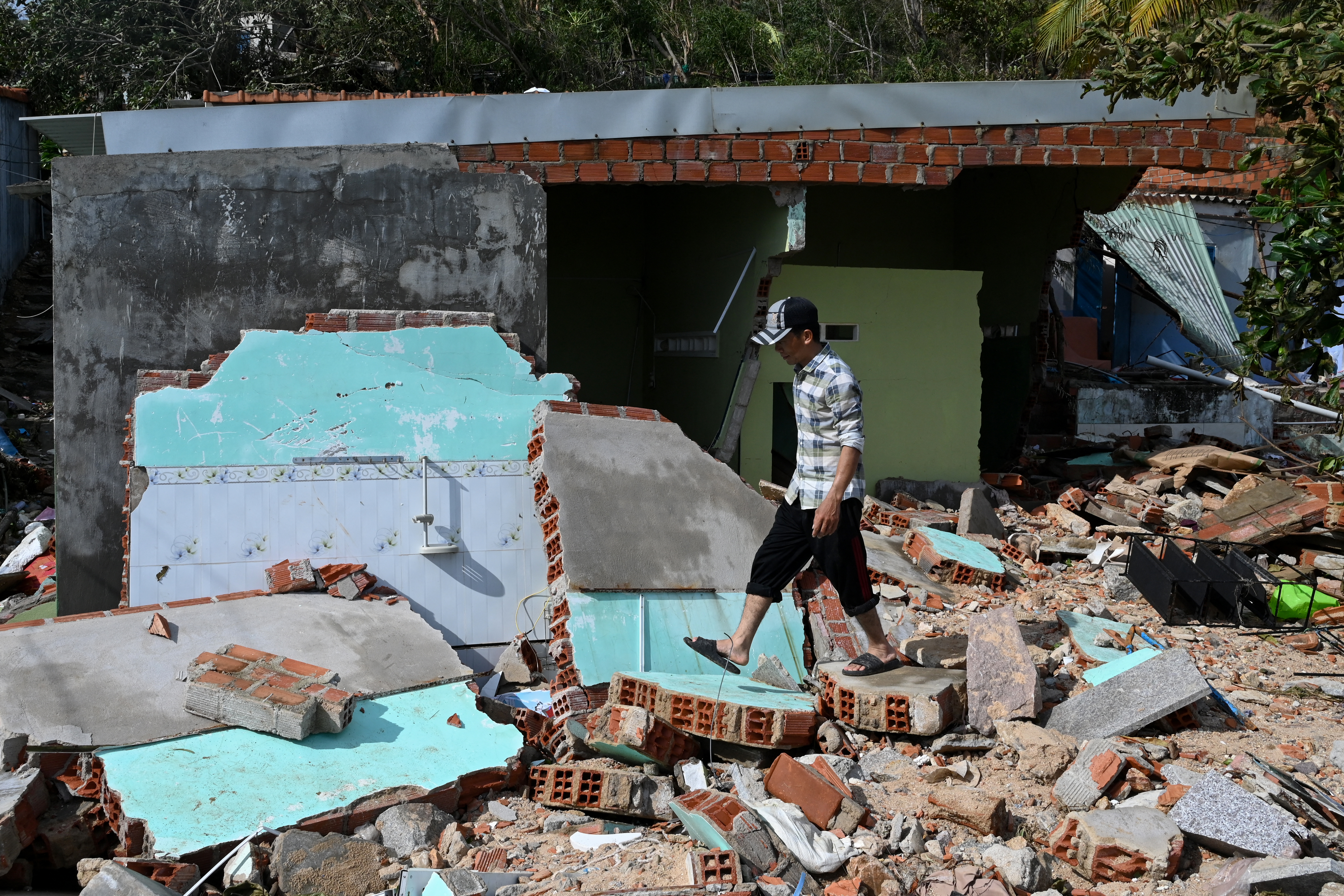
Soldiers and villagers dig through mud after a landslide swamps a village in Phuoc Loc district, Quang Nam province, Vietnam on Thursday, Oct. 29, 2020. Three separated landslides triggered by typhoon Molave killed over a dozen villagers and left dozens more missing in the province as rescuers scramble to recover more victims.
1

Typhoon Molave, landslides leave 35 dead, 59 missing in Vietnam


HANOI, Vietnam — Typhoon Molave set off landslides that killed at least 19 people and left 45 missing in central Vietnam, where ferocious wind and rain blew away roofs and knocked out power in a region of 1.7 million residents, state media said Thursday.

The casualties from the landslides bring the over-all death toll from the storm to at least 35, including 12 fishermen whose boats sank Wednesday as the typhoon approached with winds of up to 93 miles per hour. Vietnamese officials say it’s the worst typhoon to hit the country in 20 years.

At least 59 people remain missing in the landslides and at sea. The toll may rise with many regions still unable to report details of the devastation amid the stormy weather.

Rescuers dug up eight bodies Thursday morning in Tra Van village in south central Quang Nam province where a hillside collapsed on houses. The victims had taken shelter in the community as the typhoon approached, the official Vietnam News Agency reported.

In Tra Leng village, about 28 miles from Tra Van, another landslide buried a community with several houses occupied by about 45 people. Four managed to escape. Rescuers have recovered eight bodies and were scrambling to save 37 others, Vietnam News said.

Tra Leng remains inaccessible due to damaged roads and other landslides and government disaster-response teams were using bulldozers and excavators to open up a road to bring in more rescuers and heavy equipment.

Deputy Prime Minister Trinh Dinh Dung traveled to the site where soldiers were clearing up a landslide with bulldozers and ordered officers to urgently bring in troops to the landslide-hit village.

“We must reach the landslide site the fastest way. First, send in more soldiers before we can get the big machine there. We have to reach the area by all means, including by using helicopters,” he said.

As troops scrambled to rescue those buried alive in Tra Leng, another part of a rain-soaked mountainside cascaded down in a torrent of mud in nearby Phuoc Loc district Thursday morning, trapping 11 people. Three bodies were pulled out immediately by villagers, Vietnam News said.

Other villagers in Phuoc Loc were advised to flee to safety given the unstable mountain slope.

The three landslide-hit areas lie in the mountains of the hard-hit province of Quang Nam in a coastal region still recovering from floods that killed 136 people and destroyed hundreds of houses earlier this month.

Four people were killed by falling trees and collapsed houses in Quang Nam and Gia Lai provinces when the typhoon slammed into the coast Wednesday. Navy search and rescue boats found the bodies of 12 of 26 fishermen whose boats sank Wednesday off Binh Dinh province, state media said.

The typhoon blew off roofs of about 56,000 houses and caused a massive blackout in Quang Ngai province, where 1.7 million people endured the typhoon onslaught overnight in darkness, according to Vietnam News.

At least 40,000 people were evacuated to emergency shelters and authorities shut down offices, factories and schools to prevent casualties.

The typhoon left at least 16 people dead in the Philippines before blowing across the South China Sea toward Vietnam.

First Published October 29, 2020, 2:25am

Comment by Starr DiGiacomo on October 27, 2020 at 3:51am

https://www.theaustralian.com.au/breaking-news/landslide-forces-syd...

Landslide forces Sydney residents to evacuate as wild weather lashes coast

10:21AM OCTOBER 26, 2020

Sydney has been plunged into chaos after severe weather swept through the state, causing flash flooding and triggering a landslide at a remote walking trail in the city’s north.

Aerial footage shows the land spill at the Mackerel trail near Palm Beach that came within metres of several properties and caused severe damage to at least one home at Mackerel Beach.

Another two properties were “partly” damaged

Residents at 18 addresses – totalling 25 people – have been evacuated, while officials at the Northern Beaches Council have been called in to assess the damage, a NSW SES spokesman said.

Sydney’s Northern Beaches have already copped 100mm of rain in the last three days with more on the way as flash flooding prompted road closures and left many homes without power.

The news comes as Australia’s east coast battles a hammering from mother nature.

Australia has been hit by more than 2.24 million lightning strikes in just 48 hours, while damaging winds of up to 100km/h continue to rip through multiple states, with volunteers inundated with calls for help.

More storms are expected this week.

“This is peak storm season,” BOM meteorologist Dean Narramore said.

Sydneysiders can expect the storms to hit on Tuesday and Wednesday, with the peak predicted for the latter.

Comment by Starr DiGiacomo on October 23, 2020 at 1:55am

https://www.aa.com.tr/en/asia-pacific/landslide-kills-11-miners-in-...

Landslide kills 11 miners in Indonesia

All bodies recovered from coal mine in South Sumatra, says official

22-10-2020

JAKARTA

A landslide caused by heavy rains killed at least 11 miners at a coal mine in Indonesia’s South Sumatra province on Wednesday.

According to the National Disaster Mitigation Agency, the site of the landslide was a mine tunnel about 20 meters deep at Tanjung Lalang village in Muara Enim district.

“Seasonal rains in recent days have caused the landslide,” said Raditya Jati, a spokesperson at disaster mitigation authority .

He said all the bodies have been recovered and handed over to their families.

The agency previously warned that the ongoing La Nina weather phenomenon could increase total precipitation in Indonesia by up to 40% until February 2021.

The spokesperson urged people to prepare for heavy rains and strong winds and to remain alert for floods and landslides.

* Writing by Maria Elisa Hospita form Anadolu Agency's Indonesian language service in Jakarta

SEARCH PS Ning or Zetatalk

 
Search:

This free script provided by
JavaScript Kit

Donate

Donate to support Pole Shift ning costs. Thank you!

© 2024   Created by 0nin2migqvl32.   Powered by

Badges  |  Report an Issue  |  Terms of Service