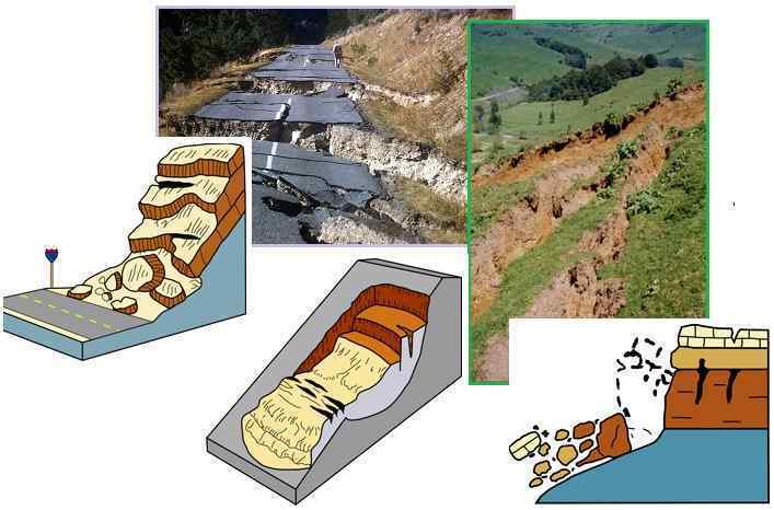
"The causes of landslides are not a mystery to mankind. Layers of rock and soil such that rain running along a clay or rock layer can create a slippery surface for the weight of the layers above it is a common cause. A rock jumble from previous mountain building, broken or fractured rock easily dislodged. We have stated that the earthquakes man experiences between the periodic passages of Planet X can be considered aftershocks from the last passage, and this is true of landslides also. Mountain building rumples the landscape, so the land is not flat but has steep ravines and hill sides. Older mountain ranges are recognized for their rounded or smoothed appearance, because of frequent landslides distributing the rubble.

"As we approach another passage, another Pole Shift, the pace of landslides has picked up. Why would this be? Plates under pressure will put pressure on regions that contain rumpled hillsides and deep ravines, as these give more readily than strictly flat land, thus act as a weak link. In addition, due to the wobble, the weather has gotten more extreme, with drought and deluge increasing in extremes. Dry ground, suddenly flooded with rainwater needing to seek its level as runoff, will create internal water slides between the rock and soil layers that constitute the rumpled hillsides. Is there an early warning system that mankind could use? The trembles that soil about to slide emits could be detected, yes. These are not earthquakes, and have their own frequency. "

ZetaTalk Chat Q&A: March 22, 2014

Views: 122420

Comment

You need to be a member of Earth Changes and the Pole Shift to add comments!

Join Earth Changes and the Pole Shift

Comment by KM on July 3, 2021 at 11:01am

https://strangesounds.org/2021/07/tsunami-of-mud-atami-japan-video-...

Tsunami of mud crashes into rows of houses in Atami, west of Tokyo, Japan – 20 people missing (videos and pictures)

mudslide japan july 3 2021, mudslide japan july 3 2021 video, mudslide japan july 3 2021 pictures Picture shows mud and debris at the scene of a landslide that has left at least 19 people missing in the Izusan area of Atami in Shizuoka Prefecture in Japan. Picture via Twitter

A powerful mudslide carrying a deluge of black water and debris crashed into rows of houses in a town west of Tokyo following heavy rains on Saturday, leaving at least 20 people missing.

Dozens of homes may have been buried in Atami, a town known for hot springs. said Shizuoka prefecture spokesman Takamichi Sugiyama.

Public broadcaster NHK gave the number of missing people at 20, but Sugiyama said the prefecture confirmed at least 19, although he said the number may grow.

mudslide japan july 3 2021, mudslide japan july 3 2021 video, mudslide japan july 3 2021 pictures
A rainy season front has dropped 805mm (32 inches) of rain in 72 hours over central Japan. A mudslide hit the seaside tourist city of Atami today, destroying homes. 19 people are missing. Picture via Twitter

Torrential rains have slammed parts of Japan starting earlier this week. Experts said dirt had been loosened, increasing landslide risks in a country filled with valleys and mountains.

Sugiyama said it had been raining hard in the area all morning. Self-defense forces will join firefighters and police in the rescue operation, he added. Evacuation warnings were issued for a widespread area.

The landslides appeared to have struck multiple times, about as fast as a car. Footage showed a powerful, black mudslide slide down a mountainside, knocking down and crushing houses and sweeping away cars in its way. Helpless neighbors watched in horror, some recording on their phones.

Atami is a quaint seaside resort area in Shizuoka prefecture, about 100 kilometers (60 miles) southwest of Tokyo. The area that was hit by the mudslide, Izusan, includes hot springs, residential areas, shopping streets and a famous shrine.

Comment by KM on April 28, 2021 at 6:18pm

https://watchers.news/2021/04/27/massive-landslide-at-great-whale-r...

Massive landslide at Great Whale River, Quebec, Canada

Massive landslide at Great Whale River, Quebec, Canada


A massive landslide took place at the Great Whale River in Quebec, Canada on April 22, 2021, dumping massive amounts of debris into the river. The slide occurred roughly 9 km (5.6 miles) upstream from Kuujjuaraapik. 

Kativik Regional Government officials said a 'considerable amount of debris' descended into the river, which could potentially dam the river, putting the communities at risk of flooding.

Kativik’s civil security department is in contact with Quebec government officials as well as experts from Laval University in order to assess the damage and do continuous monitoring, Sarah Rogers of the Nunatsiaq News noted.

According to experts, Kuujjuaraapik is located on a sandy plateau about 10 m (33 feet) above the water level and it was highly unlikely any major flooding would occur as a result of the slide.

However, secondary landslides remained a real possibility as the land in the surrounding area of the event remained unstable, the government said.

Landslide at Great Whale River, Quebec, Canada. Image credit: Copernicus EU/Sentinel-2, TW. Acquired April 22, 2021

Landslide at Great Whale River, Quebec, Canada. Image credit: Copernicus EU/Sentinel-2, TW. Acquired April 22, 2021

According to Dr. Dave Petley of The Landslide Blog, the slide is about 1.6 km (1 mile) from the crown to the channel and about 4 km (2.5 miles) from the crown to the toe.

The form of the landslide suggests that it could be a quick clay / sensitive clay failure. It appears to be quite deep-seated, probably reflecting a thick clay deposit.

"This implies that the volume of the landslide is likely to be in the millions of cubic meters," Petley said.

"There is little information as to the likely trigger at this point, but large landslides often occur in the spring as melt occurs," he concluded.

Comment by Yvonne Lawson on April 19, 2021 at 8:24pm

Massive landslide drags people’s gardens into the sea- Police issue warning

A HUGE part of North Wales mountainside has collapsed onto a beach below taking people's gardens with it.

North Wales landslide

North Wales Police tweeted that they were dealing with a huge landslide on Nefyn’s coastline near Pwllheli. It is believed to have happened between 10.30 and 11.00 this morning. A police spokesperson said: “We are currently dealing with an incident involving a large landslide on the beach at Nefyn.

Local resident, Steve Wilding-Hewitt, lives a 10 minute walk from the incident. He told WalesOnline: “We heard what had happened and went to have a look. The police have cordoned a large area off to keep people away from the scene.

"We could see the coastguard shouting to someone in their garden to stay away from the edge because it was still moving. There are some gardens that have been affected. You can see a bench that was at the end of the one of the gardens has fallen into the mud below.

"There have been some rockfalls around this coastline for a number of months, but never anything like this. It is frightening."

Christian Pilling, a nearby hairdresser, told BBC: “We had just gone down for a walk and turned round and had the shock of our lives.

North Wales landslide

Read more:  https://www.express.co.uk/news/uk/1425100/landslide-Pwllheli-nefyn-...

Comment by Tracie Crespo on April 15, 2021 at 2:54pm

May be an image of nature, coast and ocean

May be an image of nature, coast and ocean

May be an image of nature and grass

JV Medina via Facebook
2 hrs  · 
Landslide in England near the small coastal village of Seatown, in the county of Dorset.
Known as the JURASSIC COAST, this 150 kilometers stretch of coastline, starting from Bournemouth and ending in Exmouth, is a tract of rocks, cloths and white chalk arches that hide fossils and testimonies that document 185 million years of geological history.
Here erosion bare “formations” belonging not only to the Jurassic period but also to the Triassic and Cretaceous, so exploring the Jurassic Coast is equivalent to some sort of time travel.
It's a wonderful, precious area and in fact it's been previously declared a UNESCO World Heritage site.
Yesterday unfortunately 4000 tons of cliffs are crushed into the sea causing the biggest collapse of the last 60 years for the area.
This is one of the result of #MidAtlanticRidge splitting
📸 James Loveridge Photography
Comment by KM on April 10, 2021 at 1:03am

https://strangesounds.org/2021/04/apocalyptic-landslide-destroys-ro...

Gigantic landslide destroys 1 km of road in Peru – Look at the pictures, they are insane!

landslide destroys road in Peru, landslide destroys road in Peru video, landslide destroys road in Peru pictures, landslide destroys road in Peru map Gigantic landslide destroys road in Peru. 

On April 7 afternoon, a large-scale collapse occurred in the Culluchaca sector, Huari province (Áncash).

The giant landslide destroyed (and I really mean destroying) more than one kilometer of the national road PE-14 A, in the district of Pontó (Pomachaca – Yunguilla section).

Here is another video depicting the area where the landslide took place:

According to the Regional Emergency Operations Center (COER) Áncash, the village of Culluchaca has to be evacuated urgently, as it could also be swept away…

The landslide triggered widespread power outages in the districts of Huacachi, Anra, Uco, Rapayán, Paucas and Huacchis in the province of Huari, as well as in bordering provinces.

Meanwhile, the slopes are still moving and very unstable. Reparation work will only be possible when the danger of collapse diminishes.

This terrifying landslide reminds me of Lutto Kututo, another town that was swallowed by a gigantic ground ...

Comment by KM on March 29, 2021 at 4:14pm

https://www.railfreight.com/railfreight/2021/03/18/landslide-blocks...

Landslide blocks Middle Rhine Valley: are freight trains to blame?

landslide rhine

A landslide at the Middle Rhine Valley near Kestert has blocked the underlying railway, with no traffic possible the entire week. On Monday 15 March 5,000 cubic metres of stones and rubble came down, not only affecting the rails but also blocking part of the B42 federal highway between Kamp-Bornhofen and Kaub. Currently, geologists and special forces are securing the area and unblocking the way for transportation.

European rail freight is heavily impacted by the landslide, as it disrupts traffic though Europe’s most heavily used freight line: the Rhine-Alpine corridor. According to reports from the site, freight traffic diverts through the left bank of the Rhine using the Bingen route. However, this is not enough since long-distance trains are excluded from this diversion, a situation that also affects the bustling Genoa-Rotterdam route.

Train vibrations

The significant landslide seems to be the product of heavy rains and general bad weather conditions. Nevertheless, this is only the cause of the event that appears to derive mainly from the landscape’s distortions caused by heavy freight vehicles’ vibrations.

Specifically, vibrations caused by freight trains seem to be the main reason behind the phenomenon. According to Willi Pusch, chairman of the initiative against railway noise in the Middle Rhine Valley, this is the seventh rock-falling event in the region. His citizen’s initiative has warned multiple times about the consequences of bypassing freight trains that cause tremors to the mountain slopes.

With the same perspective, the region’s Pro Rheintal citizen network said that weather is not the only cause of the landslide. In contrast, they believe that rocks might crack due to wind and rain, but they collapse because of the heavy trains and the vibrations they cause. As a result, they made an open call to the German state to issue a speed limit and night driving bans for freight trains travelling through the area.


The Rhine-Alpine corridor

Back to normality

Experts working on the site mentioned that clearing processes will conclude by the week’s end. By then, traffic could return to normal. DB Cargo also confirmed that there is a reliable forecast on the way concerning the route’s navigability.

However, concerns about whether the route will be suitable for freight trains are more acute than ever. With the region’s residents partially blaming rail freight for the event and calls for extended measures, it is pretty doubtful if freight traffic could resume smoothly in this route. Even if it does under different regulations, the situation will be entirely different for Europe’s busiest rail route and operators using it. Looking for alternatives could be one solution, but all actions will be coordinated after the completion of site works and the official authorities’ report for the route’s future use.


Comment by KM on March 15, 2021 at 10:36pm

Source

Large landslide on the banks of Knappensee produces 1.5 m (4.9 feet) high tsunami, Germany


Large landslide on the banks of Knappensee produces 1.5 m (4.9 feet) high tsunami, Germany


A large landslide took place on the banks of man-made Lake Knappensee, Germany on March 11, 2021. The area where the slide took place belongs to an old open cast mining site. The event caused a 1.5 m (4.9 feet) high tsunami which damaged properties in a village on the other side of the lake.

According to local media reports, this area has a history of known geotechnical problems and was under remediation to allow the site to become a recreation attraction -- which appears to be the cause of the slide.

Experts from the Saxon Mining Authority said dump material has been removed and work was being prepared in the bank area on the same day.

The scar area is about 500 m (1 640 feet) wide and 200 m (650 feet) deep.

Knappensee, Germany on February 22, 2021. 

A damaging displacement wave of about 1.5 m (4.9 feet) was generated during the event, damaging properties in the village of Groß Särchen on the other side of the lake.

"While this [tsunami] would be small in a marine environment, in a non-tidal lake this is a significant event," Dr. Dave Petley of The Landslide Blog said.

The water masses hit a bungalow settlement, which was largely destroyed as a result. The water hit some buildings so hard that fences were washed away, and windows and walls broken.

According to Blaulicht Magazin, the banks began to be secured immediately with fences put up again so that no people were in danger.

It cannot be ruled out that there could be further landslides, experts said.

"Large failures in open cast coal mines, or in coal mine waste piles, are not rare," Petley said.

https://watchers.news/2021/03/15/knappensee-landslide-tsunami-germa...

Comment by M. Difato on February 9, 2021 at 4:14pm

Frantic rescue efforts underway following Himalayan glacier disaster

https://www.accuweather.com/en/weather-news/death-toll-feared-to-ri...

An enormous search and rescue effort continued Monday in northern India one day after a calamitous glacier collapse occurred in the Himalayan Mountains.

A piece of the Nanda Devi Glacier broke off on Sunday, allowing floodwaters to spill down the mountainside and into a valley. The wall of water destroyed one hydroelectric dam and damaged another before surging downstream.

At least 31 people have been killed by the flood, and officials fear the death toll could rise.

More than 2,000 members from the military and police groups joined the search and rescue efforts in India's northern state of Uttarakhand, the Associated Press reported Monday. The operation was focused on 37 workers trapped in a tunnel that filled with water and debris in the flood.

“The tunnel is filled with debris, which has come from the river. We are using machines to clear the way,” H. Gurung, a senior official of the paramilitary Indo Tibetan Border Police told the AP.

On Monday, 12 workers were pulled from a tunnel at the construction site of the Dhauliganga dam.

The death toll is expected to climb as officials continue to search for bodies at the two hydroelectric dams that were damaged as well as in the bodies of water downstream.

After damaging two hydroelectric dams, floodwaters raced down the mountain, prompting evacuations of villages located along the banks of the Alaknanda and Dhauliganga rivers, according to the AP.

There are reports of damaged homes along the two rivers, but it is unclear if any residents are missing, dead or injured as officials continue to investigate.

Government officials airdropped food packets and medicine to at least two flood-hit villages, the AP reported.

 https://twitter.com/vbwalia

According to Reuters, which cited an unnamed government official in India, many local villagers had been able to escape the imminent disaster as soon as they heard the loud rumble of water roaring down the mountain.

“The workers in the tunnel may not have heard anything and got stuck,” the official told Reuters.

India Prime Minister Narendra Modi said he was closely monitoring the situation shortly after being informed of the incident.

“India stands with Uttarakhand and the nation prays for everyone’s safety there,” he said on Twitter. "I have been speaking to senior authorities and getting updates on NDRF deployment, rescue work and relief operations," he added.

Dry and tranquil weather conditions allowed rescue and recovery operations to continue without disruption on Monday. A passing shower cannot be completely ruled out on Tuesday and Wednesday. However, no major precipitation is anticipated.

AccuWeather meteorologists also warn that temperatures trending higher across northern India in the coming days could cause some snow to melt along the southern slopes of the Himalayas, which can cause rivers to rise and lead to flash flooding.

Just two days before this disaster, a large avalanche occurred on the glacier, which added stress to the ice, an SDRF official told the Indian Express.

On Monday, a team was sent to the glacier to investigate the reason why a large piece broke off.

This stretch of the Himalayan Mountains in northern India is home to a chain of hydropower projects on several rivers and tributaries across the region. Authorities said they were able to save other power units downstream because of timely action taken to release water by opening gates, the AP reports.

~

Comment by Tracie Crespo on January 26, 2021 at 3:33pm

https://www.wsls.com/news/local/2021/01/26/crews-on-scene-of-landsl...

Roanoke car wash condemned after landslide causes damage

No injuries reported

WSLS

Crews are responding to a landslide at a carwash off Orange Ave NE in Roanoke


UPDATE

A Roanoke business is a total loss after a landslide caused damage on Tuesday morning.

Southern Classic Auto Wash off of Orange Ave. NE has been condemned, according to Roanoke Fire-EMS.

According to the National Weather Service in Blacksburg, the landslide is a result of around one to two inches of rain across the area.


ORIGINAL STORY

Fire crews are on the scene of a landslide in Roanoke off of Orange Avenue.

The landslide has caused damage to Southern Classic Auto Wash at 950 Orange Avenue NE, according to a 10 News crew at the scene.

No one was hurt as a result of the landslide and it’s not affecting roadways, according to Roanoke Fire-EMS.


Comment by Yvonne Lawson on December 30, 2020 at 5:30pm

Norway landslide: Houses buried in Gjerdrum village near Oslo

View of landslide from helicopter in Norway's Gjerdrum, 30 December 2020

Map

A landslide in a Norwegian village has injured 10 people, left 21 unaccounted for and buried houses under what looks like a huge slick of mud in a gully.

About 500 people have been evacuated from the village of Gjerdrum, which lies some 25km (15 miles) north-east of the capital, Oslo.

One person was seriously hurt, reports say.

"Police are designating this as a disaster," head of the local police operation, Roger Pettersen, said.

"There are dramatic reports and the situation is serious," he said, adding that people had called emergency services saying that their whole house was moving.

Several people were reported to be trapped and some were said to have managed to phone relatives appealing for help.

Of those still missing, police said in a statement: "We don't know if these people are in the landslide area, if they are away on holiday or in another way unable to contact police."

The landslide struck in the early hours of Wednesday and is reported to cover an area of 210,000 sq m (2.3m sq ft).

See more:   https://www.bbc.co.uk/news/world-europe-55484627  

SEARCH PS Ning or Zetatalk

 
Search:

This free script provided by
JavaScript Kit

Donate

Donate to support Pole Shift ning costs. Thank you!

© 2024   Created by 0nin2migqvl32.   Powered by

Badges  |  Report an Issue  |  Terms of Service