"The causes of landslides are not a mystery to mankind. Layers of rock and soil such that rain running along a clay or rock layer can create a slippery surface for the weight of the layers above it is a common cause. A rock jumble from previous mountain building, broken or fractured rock easily dislodged. We have stated that the earthquakes man experiences between the periodic passages of Planet X can be considered aftershocks from the last passage, and this is true of landslides also. Mountain building rumples the landscape, so the land is not flat but has steep ravines and hill sides. Older mountain ranges are recognized for their rounded or smoothed appearance, because of frequent landslides distributing the rubble.

"As we approach another passage, another Pole Shift, the pace of landslides has picked up. Why would this be? Plates under pressure will put pressure on regions that contain rumpled hillsides and deep ravines, as these give more readily than strictly flat land, thus act as a weak link. In addition, due to the wobble, the weather has gotten more extreme, with drought and deluge increasing in extremes. Dry ground, suddenly flooded with rainwater needing to seek its level as runoff, will create internal water slides between the rock and soil layers that constitute the rumpled hillsides. Is there an early warning system that mankind could use? The trembles that soil about to slide emits could be detected, yes. These are not earthquakes, and have their own frequency. "

ZetaTalk Chat Q&A: March 22, 2014

Views: 122993

Comment

You need to be a member of Earth Changes and the Pole Shift to add comments!

Join Earth Changes and the Pole Shift

Comment by Derrick Johnson on July 16, 2015 at 7:41am

UPDATE: WV 82 remains closed for emergency cleanup of landslide

Posted: Wednesday, July 15, 2015 3:24 pm

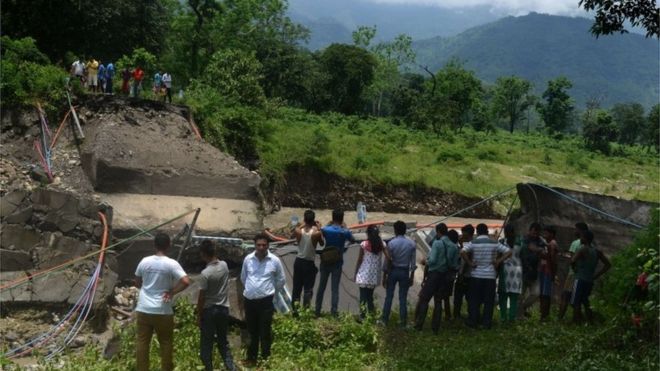
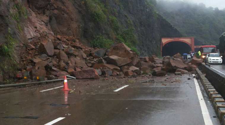
WV 82 remains closed 2.6 miles East of Birch River due to a rock slide that occurred Monday, July 13. The West Virginia Division of Highways has been working diligently to remove rock and debris from the roadway. Additional storms on Monday, July 13 and Tuesday, July 14 hindered cleanup efforts and crews were forced to stop work due to safety concerns.

The WVDOH has removed approximately 2,500 tons of rock from the roadway, and workers estimate an additional 2,500 tons is left to haul away. 

WV 82 at the site of the slide is expected to reopen during the evening hours of Friday. Traffic is advised to follow WV 20 to Craigsville and WV 55 to US 19 at Muddlety.

This section of WV 82 was closed on Monday by a large landslide caused by heavy rain. State forces are working to remove the rocks and debris. The road is scheduled to re-open to one-lane traffic on this evening at 6:00 p.m.

Traffic is advised to follow WV 20 to Craigsville and WV 55 to US 19 at Muddlety. WVDOH expresses their apologies for the inconvenience this may cause the citizens and guests to the area. The detour is necessary until the rocks and debris are removed from the roadway for the public’s safety.

Motorists are asked to observe all traffic control signs and devices and use caution while traveling through the work zone once it is re-opened to one-lane traffic. Delays are expected; therefore, motorists should allow additional time for their commute or seek alternate routes.

Source: http://www.register-herald.com/news/update-wv-remains-closed-for-em... 

Comment by Howard on July 5, 2015 at 10:03pm

Nepal Quakes Trigger 5,600 Landslides (Jun 19)

Approximately 5,600 landslides have resulted from the 25 April Gorkha and 12 May Dolakha earthquakes, as well as reactivations of landslides present before these earthquakes occurred.

Landsliding is limited to a zone that runs east-west, approximately parallel to the transition between the Lesser and High Himalaya. This zone includes parts of the districts of Gorkha, Dhading, Nuwakot, Rasuwa, Sindhupalchok, Dolakha, Ramechhap, and Khavre.

There have also been numerous reports of cracked ground in the affected areas.

Source

http://ewf.nerc.ac.uk/2015/06/30/updated-30-june-landslide-inventor...

Comment by jorge namour on July 5, 2015 at 2:38pm

ISERE / HIGH-ALPS: the mountain began to collapse in the lake Chambon
FRANCE

with our correspondent in Isère Serge Pueyo | 04 Jul 2015

http://www.leparisien.fr/faits-divers/isere-la-sirene-annonce-la-ch...

https://translate.google.com.ar/translate?sl=fr&tl=en&js=y&...

Saturday the regular departures of several hundred m3 were recorded in early evening

Mizoën (Isère) yesterday. A section of this mountain will collapse into the lake, which could cause a wave of 20 m on the water.

That's it, the mountain began to crumble Saturday night around 8:45 p.m. in the lake Chambon. According to witnesses on site, a slope is currently fracture.

n the afternoon, at 16:25, the siren sounded to announce that hundreds of thousands of cubic meters of rock must soon fall into the lake.

A fall that could trigger a wave of 20 meters high.

On 10 April, the authorities find disturbing cracks on the roof of the tunnel Chambon in Mizoën (Isère) in the Massif de l'Oisans. This is the result of a landslide over on a slope of the mountain. The tunnel and the 1091 county road, which connects Grenoble to Briançon, are closed. Tourism professionals from the Grave Valley saw their sales collapse. Residents must walk almost an hour on a trail or take boats in place of the lake to be able to work on the other side of the tunnel. On June 23, the experts note that the landslide accelerates dangerously. The work is then stopped in the tunnel.

hursday new alert. Geologists announce that the collapse of an area 280 m long, 100 m wide and 25 m thick, on a slope of 50 degrees, is Friday, Saturday or Sunday. These are 100 000 to 800 000 m 3 which will slide into the lake Chambon. No harm to the population because the banks are not urbanized.

The wave should not damage the dam

In the village of Freney-d'Oisans, under the dam, residents are worried, "he The dam will withstand this wave. If he gives in, we're all dead " , assures Isabelle. Officials of EDF want to be reassuring: "The sliding axis opposed to the dam. The wave will head to the opposite shore. At the dam, it is expected a wave of only 3 to 4 m, which will not damage the book. 35 m currently separate the current level of the water and the dam crest, "explains Stéphane Toletti, director of the hydraulic group Ecrins-Vercors.

Since Friday, police patrols crisscross the area to prohibit hikers, fishermen and curious, access to banks. CONTINUE...

UPDATDE

https://translate.google.com.ar/translate?sl=fr&tl=en&js=y&...

ISERE / HIGH-ALPS Chambon lake: part of the land broke away from the mountain JULY 5 2015

The massive collapse of the mountain has not yet occurred but regular departures of several hundred m3 have already occurred since Saturday ...

MAP: https://en.wikipedia.org/wiki/Lac_du_Chambon

Lac du Chambon is a lake in Isère, Rhône-Alpes, France. At an elevation of 1040 m, its surface area is 1.4 km².

Comment by Derrick Johnson on July 2, 2015 at 6:48am

India landslides kill 38 in Darjeeling

  • 1 July 2015
Officials blamed the landslide on incessant rains in the area for the past couple of days

Landslides triggered by heavy rains have killed at least 38 people in India's tea-growing region of Darjeeling, police say.

Rescuers were digging through debris looking for survivors after landslides struck homes in Mirik, Kalimpong and Darjeeling towns in West Bengal state, officials said.

More people are feared trapped under mounds of mud and debris.

Roads and communication links have been extensively damaged, officials said.

Incessant rains in the area for the past couple of days caused the landslide, district magistrate Anurag Srivastava told the BBC's Amitabha Bhattasali.

Thousands of tourists are now stuck in the picturesque hilly area, our correspondent adds.

The landslides have brought down a number of homes on the slopes of the hills, news agency AFP quoted senior state police official Anuj Sharma as saying.

Darjeeling district, which attracts thousands of tourists every year, is about 600km (372 miles) north of the state capital, Kolkata (Calcutta).

Source: http://www.bbc.com/news/world-asia-india-33341630 

Google Maps 

Comment by Derrick Johnson on July 2, 2015 at 6:41am

Mechi highway obstructed by landslide

  • Roads in Dolakha & Sindhupalchowk at high risk

ILAM, JUL 01 - Incessant rainfall since last night has triggered landslides along various locations of the Mechi highway.

As a result traffic has been obstructed. Landslip in five locations in the Harkate-Kiteni section of the highway has stopped the road for traffic since this morning, according to Area Police office in Pashupatinagar. It will take some time before the debris is cleared and the road opened for traffic, said police inspector Padam Thapaliya.

Meanwhile, hundreds of travelers on their way to Ilam from Jhapa and vice-versa have been left stranded. Many roads in Dolakha and Sindhupalchowk are reported to be at risk of being blocked or swept away by landslides triggered by incessant rainfall since the past few days.

The 55-kilometer road section of the Araniko highway leading to Kodari from Bandeu of Sindhupalchowk is at high risk of landslip, the Division Road Office in Dolakha has said.

Hills above the road had suffered cracks in the earthquake and there is likelihood of severe landslide, said chief of the Office Kamlesh Kumar Karna. There is also risk of indundation by the Bhotekoshi river, he said.

The 92-kilometer-long Pushpa Lal highway from Lamosanghu of Sindhupalchowk to Miltikhola of Dolakha is also in danger of being blocked by landslide. Road sections in Bocha, Charnawati and Sakhine and in Bhirkot are at risk of landslide, said engineer at the Office Subaraj Neupane.RSS 

Source: http://www.ekantipur.com/2015/07/01/top-story/mechi-highway-obstruc... 

Google Maps 

Comment by Howard on June 26, 2015 at 4:03am

Massive Landslide Causes Tsunami in SW China (Jun 24)

A substantial landslide triggered local tsunami waves causing 13 vessels to sink.on the Daning River, a tributary of the Yangtze, in Wushan County, Chongqing.

One person is missing and four sustained injuries after the landslide on Wednesday evening at 6:40 p.m.

An initial check showed all people onboard the anchored ships had gone ashore before the landslide.

However, one person, who was on the bank, is unaccounted for and four others were injured, one of whom is in a critical condition, an official with the Yangtze River Navigational Affairs Administration said.

The site of the landslide is only 110 km upstream of the Three Gorges Dam.

Sources

http://globaltimes.cn/content/928859.shtml

http://blogs.agu.org/landslideblog/2015/06/25/daning-river-a-landsl...

Comment by Derrick Johnson on June 23, 2015 at 6:41am

Landslide halts traffic on Pune-Mumbai Expressway

A staffer at the Expressway control room said that the landslide occurred around 10 am and large rocks blocked the entire Pune to Mumbai lane.


Pune, Pune landslide, Pune traffic, Pune traffic jam, Pune Mumbai Expressway, Khandala tunnel, Khandala tunnel landslide, Pune latest news, India latest news
AdTech Ad
Landslide near Khandala tunnel on Monday morning. (Source: Express photo)
By: Express New Service | Pune | Updated: June 22, 2015 1:45 pm

The traffic on the Pune-Mumbai Expressway was badly affected after landslide on the lane towards Mumbai near Khandala tunnel on Monday morning. Long queues of vehicles were seen on one side of the Expressway.

A staffer at the Expressway control room said that the landslide occurred around 10 am and large rocks blocked the entire Pune to Mumbai lane. The traffic was diverted to the Pune Mumbai Old highway and work to remove the debris had started around 11.30 am. No casualties were reported in the landslide.

The staffer added that half the lane was cleared around 12 noon and the traffic was expected to become normal around 1.30 pm. The patch of the highway between Borghat and Khandala is regularly hit by traffic jams especially during the rainy season.

Source: http://indianexpress.com/article/cities/pune/landslide-halts-traffi... 

Comment by KM on June 11, 2015 at 2:55pm

http://www.thestar.com.my/News/Regional/2015/06/11/Landslides-kill-...

Landslides kill at least 15 after heavy rain in Nepal

An area in Nepal's mountainous northwest Myagdi district is seen being affected by a landslide, on May 24, 2015. - AFP

An area in Nepal's mountainous northwest Myagdi district is seen being affected by a landslide, on May 24, 2015. - AFP

KATHMANDU - At least 15 people were killed and more than a dozen reported missing after heavy rains triggered landslides in northeastern Nepal, a local government official said on Thursday.
Surendra Kumar Bhattarai said the landslides, which hit just weeks after twin quakes that killed 8,700 people in the Himalayan nation, swept away a dozen houses in mountainous Taplejung district.
"We have found the bodies of 15 people, and around 15 others have been reported missing. They were said to be inside the destroyed houses," said Bhattarai, the assistant district chief.
"Ten people suffered injuries and police are on the ground helping the wounded," he told AFP.
Scores of people die every year from flooding and landslides during the monsoon season in Nepal.
Taplejung escaped serious damage in the April 25 and May 12 earthquakes, which triggered landslides and destroyed half a million homes, leaving thousands without shelter just weeks ahead of monsoon rains. - AFP

http://www.foxnews.com/world/2015/06/11/15-feared-dead-as-landslide...

21 dead, dozens missing after landslide hits 6 villages in Nepal

A landslide triggered by heavy rainfall buried at least 21 people and left dozens missing as they were sleeping at night in six villages in Nepal's mountainous northeast, officials said Thursday.

Rescuers dug out the bodies and searched the rubble for survivors in Taplejung district, about 310 miles east of the capital, Kathmandu, said police official Shanti Raj.

At least 24 people are missing but the number could be higher, he said.

Comment by Mark on June 11, 2015 at 11:16am

School campers trapped by massive landslip

http://www.nzherald.co.nz/nz/news/article.cfm?c_id=1&objectid=1...

A group of school campers blocked in by a landslip in Fiordland haven't let "avalanches" and torrential rain put a damper on their fun.

The 30-strong group of Limehills School teachers, parents and students arrived at Deep Cove camp on Monday for a week-long trip.

But a landslide triggered by heavy rain down south was discovered around 8am on Tuesday, blocking the road needed for the group's exit.

However, the students should still be able to return home on schedule.
Real Journeys Te Anau, which is in charge of transporting the school group to and from the camp, said the slip should be cleared by Friday, when the students were due to leave.

"Contractors are in there fixing the road and at this stage they are saying they should have it open for Friday so we're confident as we can be that the school group will come out on Friday as per their normal schedule," spokesman Paul Morris said.

Comment by Mark on June 8, 2015 at 6:26pm

Landslide-hit Newquay beach closed after further cracks found

http://www.bbc.co.uk/news/uk-england-cornwall-33045491

A beach which was closed after a landslide will remain shut for the summer months after engineers found further cracks in the cliff.
In February, about 100 tonnes of debris fell on to the access road at Great Western Beach in Newquay.
Engineers believe there is a risk of further rock falls and Cornwall Council has closed the road at both ends - the only public access to the beach.
Cornwall councillor Geoff Brown said it was "very disappointing".
'Worst possible news'
The cracks have opened up both in the access road and on the cliff above the beach complex.
Beach huts have been evacuated and the surf school is thought to have relocated.
Mr Brown said: "It's the worst possible news we could have had, but public safety comes first."

SEARCH PS Ning or Zetatalk

 
Search:

This free script provided by
JavaScript Kit

Donate

Donate to support Pole Shift ning costs. Thank you!

© 2025   Created by 0nin2migqvl32.   Powered by

Badges  |  Report an Issue  |  Terms of Service