ZetaTalk: Most Terrible Day
India: Majuli, world's largest river island is shrinking and sinking
February 18, 2014
Snuggling in the lap of the massive Brahmaputra, the gorgeous hotspot of Assam is now facing grave threats of abrasion caused by the gigantic river itself. The largest river island Majuli is submerging due to excessive sediment discharge caused by frequent low magnitude seismic disturbances. It has been reported that the surface area of the island, originally 1100 square kilometres has shrunk drastically and now areas 352 square kilometres.
----------------------------
ZetaTalk ™
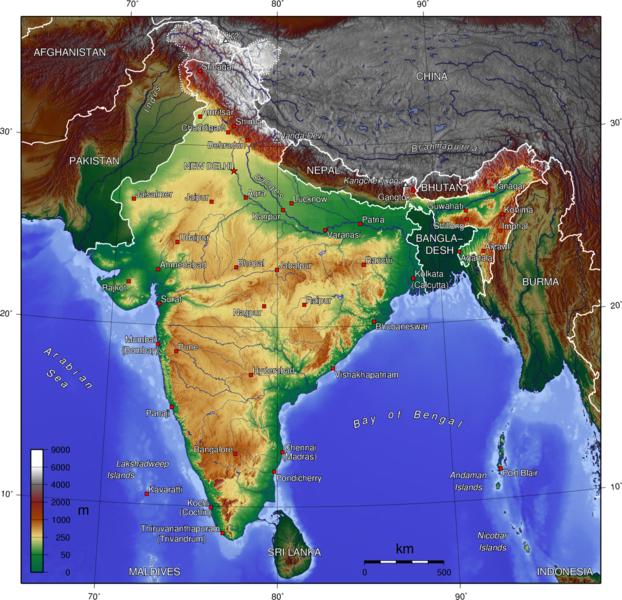
More than the country of India and Bangladesh and Bhutan will be pushed under the Himalayas. Check the topographic map and see where the wrinkles are. This is where land has been rumpled as something was pushed under it. Note that along the border with Burma and Tibet and Nepal, that the lands of India are lowlands, where the land has been pushed down in the recent past. Why would the highlands of India be just in the center of the country, and not border the high Himalayas? This is what will become of India and all on that plate that is being pushed down and under. Those in India are advised not to seek high ground within Indian's interior, but to head to the Himalayas, to Tibet and Nepal and China or the high mountains that are officially Indian territory - Srinagar. Pakistan will also be high ground but the area will rupture to become a new seaway, so this is unstable territory and the lowlands will be flooded during the hour of the shift.
Views: 2437
Comment
SEARCH PS Ning or Zetatalk
https://poleshift.ning.com/forum/topics/last-trimester-event-timeline
NEW POLE SHIFT UPDATE!
Nancy Lieder November 11, 2025 ZetaTalk Chat for November 30, 2025 - Earth Changes and the Pole Shift
Nancy Lieder, Emissary of the Zetas.
https://poleshift.ning.com/xn/detail/3863141:Comment:1168188
Awakening to the Alien Presence ZetaTalk
The truth will likely never to be known to the public but be washed away in the Nibiru panic soon to engulf the world.
The Worst of the Cover-Up
https://poleshift.ning.com/profiles/blogs/the-worst-of-the-cover-up
Main Establishment Lies
https://poleshift.ning.com/profiles/blogs/main-establishment-lies
Donate
© 2026 Created by 0nin2migqvl32.
Powered by
![]()
You need to be a member of Earth Changes and the Pole Shift to add comments!
Join Earth Changes and the Pole Shift