7 of 10 SINKING; Philippines: Metro Manila aerial view floods! 49 dead, 2 million affected by floods! This flood is worse than storm ‘Ondoy’! India: Assam 128 dead, Uttarakhand 70 dead by floods!
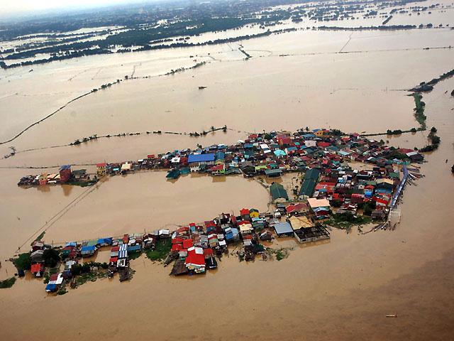 Land has turned to sea in Bulacan after days of rain


 Philippines SINKING:
/ 49 dead, 2 million affected by habagat floods. Forty-nine people have died and more than 2 million people in Metro Manila and several Luzon provinces have been affected by heavy rains caused by a storm-enhanced "habagat" or the southwest monsoon. /
/ The Philippines began a massive clean-up on Thursday after floods swept the capital and nearby provinces, forcing residents to wade through shoulder-deep waters in some places after nearly two weeks of monsoon rains killed 91 people. /
/ Nearly 500,000 residents of Bulacan were affected by the recent floods caused by nonstop rains, the provincial government said. Floodwaters in Bulacan became chest-deep on Thursday, affecting several barangays. Residents rushed to either the second floor or roof of their homes, while those who wanted to move to safer ground were rescued by Bulacan personnel. Half of Hagonoy is now submerged in floodwater. /
/ Flood hits 200 barangays in 18 Pangasinan towns. Some 200 barangays in 18 towns of Pangasinan, mostly along the Agno River, were flooded as a result of the continuing release of water from the San Roque Dam. /
Strange flooding (worse than Ondoy) without name -
/ “The victims will have to rebuild their lives from the tragedy and devastation.
This flood is worse than storm ‘Ondoy’ (that hit Metro Manila and is environs less than three years ago).
I hope serious government and private sector efforts to build back better the affected communities would start immediately. We must learn the lessons of Ondoy’’ which this recent widespread flooding brings to fore once again,’’ she said. /
/ Some people observed that the amount of rainfall dumped by the weather disturbance, which doesn’t even have a name like typhoons, has been heavier than Ondoy’s, although the floodwaters in 2009 rose with unusual and deadly speed. A resident in the lakeshore area of Muntinlupa said her home was flooded up to the second floor for the first time – which didn’t happen during Ondoy. Their community was evacuated Monday night. Even without his pronouncement, people are already resigned to the idea that flooding in Metro Manila is going to get worse in the coming years. /
/ There were certainly so many questions begging to be answered. As with “Ondoy,” the flooding through Metro Manila and much of Southern Tagalog, Central and Northern Luzon was not caused by a typhoon (Ondoy was dubbed a tropical storm). TV networks, at a loss for an easy handle with which to describe their extensive coverage, resorted to a descriptive term like “Hagupit ng Habagat” (roughly, “the westerly wind’s lash,” how poetic no?) or “Bagsik ng Habagat” (the west wind’s cruelty). The weather presenter at CNN explained the flooding with a mix of meteorology and geography. He tracked the path of Tropical Storm “Haikui,” which was said to have drawn the rains over Luzon much like a magnet would, and explained the particular vulnerabilities of low-lying Manila and surrounding areas by pointing out the surrounding bodies of water (Manila Bay, Laguna Lake, Pasig and other rivers and tributaries).
But we have experienced typhoons and other sorts of weather disturbances before,
without seeing flooding of such an extent and duration.
And we all know our geography, although it seems that, in retrospect, we may have known what our geography is like but chose to ignore it, building in vulnerable flood plains, blocking natural waterways, denuding our forests and watersheds and blocking natural flood passageways with structures and mounds of garbage. /
India TILTING & BACKWASHING:


Assam -
/ 128 people killed, 6,000 cattle dead in Assam floods. Minister of State for Home Mullappally Ramachandran, answering questions in the Rajya Sabha on the Assam floods, said that 1,252 bridges, culverts and wooden bridges were also washed away and 11.50 km of embankments were damaged. /
/ Around 1.50 lakh people have been hit by floods in seven districts in Assam where the water level of the Brahmaputra and its tributaries have risen following incessant rainfall in the catchment areas. People have been affected in 132 villages under 12 revenue circles in Baksa, Barpeta, Dhemaji, Kamrup, Nalbari, Sibsagar and Sonitpur districts in the third wave of floods, official sources said on Wednesday. In the worst-ever flood during the last decade, 126 people lost their lives during the first and second wave of floods while more than 600 animals perished in the Kaziranga National Park. /
Jammu & Kashmir, Uttarakhand, Madhya Pradesh and Himachal Pradesh -
/ Monsoon rains which remained subdued till July erupted in the first week of August to trigger flash floods in Jammu & Kashmir, Uttarakhand, Madhya Pradesh and Himachal Pradesh in the past few days. Heavy rains, which claimed nine lives in Madhya Pradesh, are likely to weaken in the next 24-48 hours bringing respite to the flood-hit areas of central and western Madhya Pradessh /
Arunachal Pradesh -
/ Floods cause extensive damage in Arunachal. Recent flashfloods triggered by heavy rainfall in the upper reaches has badly affected paddy fields, horticulture gardens, fish ponds, irrigation channels and water pipelines at Sille, Ruksin, Bilat and Mebo circles in East Siang district of Arunachal Pradesh /
Uttar Pradesh -
/ Seven UP rivers in spate Lucknow: Seven rivers in Uttar Pradesh are in spate as rains continued in most parts of the state. The Burrhi Rapti river in Kakrahi, Sharda river in Palia Kalan, Ghaghra river in Elgin Bridge, Ayodhya and Turtipar, Rapti river in Balrampur were flowing above the danger mark while the Ganga river was flowing at the danger mark in Varanasi, the Central Water Commission said. /
Bihar -
/ Floods in six Bihar districts. Patna: Floods triggered by heavy rains in Nepal have affected 158 panchayats spread over six districts in Bihar and affected 1.53 lakh people, Chief Minister Nitish Kumar told the state legislative council on Wednesday. /
-------------------------------------
Philippines:
No 'instant noodle'
Umbrella, check. Jacket, check. In this monsoon season, these items are must-haves for anyone leaving the house. Toss in rubber footwear, a bottle of alcohol, perhaps a change of clothes. And how about a fishing bib?
That’s waterproof overall, used – as the name implies – for fishing. But it could be useful in floods several feet deep.
A bib, with heavy-duty waterproof boots attached, was a hit in our newsroom the other day. It was worn to the office by one of our employees, who said it is made in China but was sent to her from Germany.
The material, similar to those used for flak vests, is heavy and can be too warm when worn over regular clothing, including leggings. The boots can be cumbersome for walking and catching a ride on the LRT.
The employee told us people stared at her bib – an unfamiliar sight in this country – during her commute through flooded streets. But unlike many employees who arrived in the office like wet rats for the second straight day, she was dry and didn’t have to watch out for symptoms of leptospirosis or skin disease from contact with filthy water.
There are rubber boots, but even the tallest pairs are useless in floods several feet deep. So now several people in the newsroom are considering investing in a fishing bib. Prices for such waterproof garments range from $200 to about $400 without the boots. That amount is still lower than the cost of cleaning and repairing a car that has been damaged by floods. Or the cost of medical treatment for certain water-borne diseases.
Wearing a bib can also ease worries about running into creatures that are flushed out by rains and floods, including poisonous toads, centipedes, sewer rats, and even snakes and slugs. At the Philippine General Hospital, a guard caught catfish in the flood.
It’s a sign of the times that we are seriously looking at the fishing industry for more equipment to survive cataclysmic flooding. Will an amphibious fishing vehicle, for example, be useful in the flooded streets of Metro Manila? In floods two to four feet deep, it certainly works better than a delivery truck.
After Metro Manila was paralyzed by typhoon “Ondoy” in September 2009, our office considered buying rubber boats similar to those used for rescue operations by the police. The idea is still being kicked around.
In certain towns in Central Luzon, residents already keep small canoes at home, for use during floods. I’m not sure if the multibillion-peso megadike has been useful, but the areas around it sure looked submerged during Ondoy and subsequent strong typhoons.
Neither does the megadike for the Camanava area look like it’s doing what it’s supposed to do. But then the flood control project, whose original cost of P3.2 billion has ballooned to P5.9 billion, is only 99 percent finished, according to the Department of Public Works and Highways. After 100 percent completion, maybe we’ll see positive results.
President Aquino has lowered public expectations for flood control, saying an effective system will take years to complete.
Even without his pronouncement, people are already resigned to the idea that flooding in Metro Manila is going to get worse in the coming years.
* * *
At least rainfall tracking seems to have improved enough for weather forecasters to introduce color-coding in their rain and flood alerts.
Yellow is the lowest advisory for likely flooding from heavy rain. Yesterday the colors were changed, with orange instead of green the next alert level, and red the worst.
I was caught in a yellow alert for “intensive rain” the other day. I heard it on my car radio at close to 2 p.m., when the intensive rain was already pouring and I was stuck in a massive traffic jam as floodwaters rose again.
Because the morning had started with much improved weather, people returned to work in areas where flooding had subsided. But the weather turned horrid again at around the same time that the yellow alert was issued.
I was told that the alert was not quite a forecast but merely a report of heavy rainfall detected by the weather bureau. We can, of course, deduce this ourselves simply by looking out the window, or if we happen to be caught in the rain.
The forecasting part in the new system is the duration of the intensive rain – in the case of the yellow alert, about two hours, according to the Philippine Atmospheric, Geophysical and Astronomical Services Administration (PAGASA).
In the evening, PAGASA raised its alert to red over eastern and northern Metro Manila – areas already among the worst hit by the massive flooding.
I’m not sure if the system failed, or if no one was paying attention to alerts from PAGASA, but Metro Manila looked completely unprepared for the monsoon-induced torrential rains, which started pouring Sunday night.
Some people observed that the amount of rainfall dumped by the weather disturbance, which doesn’t even have a name like typhoons, has been heavier than Ondoy’s, although the floodwaters in 2009 rose with unusual and deadly speed.
A resident in the lakeshore area of Muntinlupa said her home was flooded up to the second floor for the first time – which didn’t happen during Ondoy. Their community was evacuated Monday night.
We’ve had several dreadful experiences with monsoon rains in the past – they can be as destructive as super typhoons – so priority should have been given to improving the capability of the weather bureau to predict the amount of rainfall.
The acquisition of more Doppler radars has helped, but we’re still waiting for something like what we see in several countries: rainfall forecasts for the next 24 hours, plus weekly and monthly forecasts.
We don’t need to be told that there’s no “instant noodle” solution to the problem. Seeing what’s happening in Camanava, Marikina and the communities around Laguna de Bay, it’s clear that things are going to get worse, and we can’t be sure it will get better afterwards.
All we can do is adapt to our situation. Buy a fishing bib. Or at least rubber boots.
http://www.philstar.com/Article.aspx?articleId=836451&publicati...
^^^^^^^^^^^^^^^^^^^^^^^^^^^^^^^^^
Answers after ‘habagat’
Now that the floodwaters have receded and the sun is out—at least in our part of the metropolis—the time has come to point fingers. Actually, it began even as many areas were still being threatened by floods, and hundreds of thousands, in fact entire communities, had been rendered homeless, congregating, wet and shivering, in makeshift evacuation centers.
There were certainly so many questions begging to be answered. As with “Ondoy,” the flooding through Metro Manila and much of Southern Tagalog, Central and Northern Luzon was not caused by a typhoon (Ondoy was dubbed a tropical storm). TV networks, at a loss for an easy handle with which to describe their extensive coverage, resorted to a descriptive term like “Hagupit ng Habagat” (roughly, “the westerly wind’s lash,” how poetic no?) or “Bagsik ng Habagat” (the west wind’s cruelty). The weather presenter at CNN explained the flooding with a mix of meteorology and geography. He tracked the path of Tropical Storm “Haikui,” which was said to have drawn the rains over Luzon much like a magnet would, and explained the particular vulnerabilities of low-lying Manila and surrounding areas by pointing out the surrounding bodies of water (Manila Bay, Laguna Lake, Pasig and other rivers and tributaries).
But we have experienced typhoons and other sorts of weather disturbances before, without seeing flooding of such an extent and duration. And we all know our geography, although it seems that, in retrospect, we may have known what our geography is like but chose to ignore it, building in vulnerable flood plains, blocking natural waterways, denuding our forests and watersheds and blocking natural flood passageways with structures and mounds of garbage.
The last seems to have come in for particular outrage. There is an online petition asking young citizens to sign a pledge not to throw garbage. Typhoon “Gener” brought the reality of our profligate garbage habits to visible (and odorous) reality, what with the virtual islands of trash floating on the seaside walk of Manila Bay. And of course, there are the graphic footage of creeks and rivers choked by garbage, usually along so-called “informal settlements.”
* *
Still, the search for answers to our “whys” continues.
Rep. Edcel Lagman, main sponsor of the Reproductive Health bill, issued a statement that “no amount of supplemental fund will adequately address calamities if the population problem remains unresolved.” He adds: “A huge population growth exacerbates calamities.”
Clearly linking population growth with the “problems spawned by calamities and ecological despoliation,” the congressman from Albay declared that “an inordinately huge population growth rate makes difficult and expensive risk management during calamities, contributes to the destruction of the environment, creates an imbalance in the ecosystems and hinders the efficacy of climate change mitigation and adaptation.”
He explains: “As population expands, people reside precariously along riverbanks; invade forestlands for habitation and cut trees for livelihood; and clog waterways with their garbage, which all compound the calamity and deter efficient risk management.”
* * *
Lagman finds vehement agreement from an unexpected source, but one whose opinion is not to be taken lightly.
He is geologist Kelvin Rodolfo, who gained a measure of fame in the wake of the Mt. Pinatubo eruption.
Says Rodolfo: “the floods and the reproductive health bill are closely connected.” A “major cause” of the Manila and Central Luzon floods, he says, is “increased use of groundwater by the growing population. This causes the coastal plains to subside, in places more than 10 inches per year.”
Citing his work and discussions with Dr. Fernando Siringan of UP Marine Science Institute and Project Noah’s Mahar Lagmay, Rodolfo bids me to talk with the two men because “you might find what they know interesting.” I’ll do just that, Dr. Kelvin.
Anyway, he offers this excerpt from a paper he and Dr. Siringan published in 2006:
…“The Philippine population, mostly residing on coastal plains, is squeezed, figuratively, between the two jaws of a vice: its own rapid growth, and the subsidence and flooding generated by its own use of groundwater. We may take little comfort in the realization that, although subsidence is accelerating, it must stop eventually, even without proper regulation. As groundwater continues to be mined, subsidence, tidal incursion and storm flooding can only get worse. In due course, however, the groundwater may be so depleted or contaminated by intruding saltwater that its use will stop; or subsidence and attendant tidal and storm flooding may render portions of the coastal plains no longer habitable, which would also result in reduced pumping. In the end, though, whatever subsidence has occurred will be permanent, and the sooner this is recognized, the sooner ameliorative steps can be taken ….”
More on this in later columns.
* * *
TO CAP this search for answers, urban planner and architect—and eager busybody and concerned citizen—Felino “Jun” Palafox sent over a bunch of papers prepared even long before Ondoy struck, on his studies on the vulnerability of Metro Manila and surrounding areas to natural calamities, including flooding. Reading through his papers and presentations, one can’t help but wonder if the recent floods would have been avoided, or done a lot less damage, if only the Arroyo and now the Aquino governments had given Palafox’s educated and well-researched recommendations a respectful listen.
Looks like Palafox’s conclusions and recommendations will likewise fill up this column’s agenda for the next few days, at least.
http://opinion.inquirer.net/34399/answers-after-habagat
^^^^^^^^^^^^^^^^^^^^^^^^^^^^^^^^^^^^^^^^
Metro Needs Rehabilitation Plan — Legarda
Metropolitan Manila needs a comprehensive recovery and rehabilitation plan to reduce the vulnerability of its residents from disasters and increase the resilience of all sectors to floods.
This was stressed yesterday by the Senate climate change committee chaired by Sen. Loren Legarda as the week-long heavy rains and the floods began to subside.
“The victims will have to rebuild their lives from the tragedy and devastation. This flood is worse than storm ‘Ondoy’ (that hit Metro Manila and is environs less than three years ago). I hope serious government and private sector efforts to build back better the affected communities would start immediately. We must learn the lessons of Ondoy’’ which this recent widespread flooding brings to fore once again,’’ she said.
Legarda stressed that “one lesson is clear: We must realize that heavy and excessive rainfall is part of the ‘new norm’.’’
She pressed for the immediate implementation of the new laws that Congress had passed designed to promote disaster and climate risk reduction.
‘’We must endeavor to prevent or reduce flood disaster. As the old adage goes, prevention is always better than cure,’’ she said.
Legarda said her proposed plan should be developed and implemented together with key stakeholders and must not be abandoned like the recovery and rehabilitation efforts following ‘Ondoy.’
“More importantly, we must assess our respective work in reducing flood risk, if we are really making any headway amid the ‘new norm’ we experience in this era of climate change. Are we working on preventing and mitigating the floods or merely responding to their onslaught?’’ she asked.
‘’Pursuant to our new laws, we must put greater emphasis and invest more (70-30) on disaster prevention and mitigation and risk reduction measures (which bring cost benefit returns as much as: $1 invested in prevention yields $7-14 saved in response cost according to United Nations and World Bank studies) over disaster response (which is costly and unsustainable). This is the new paradigm shift. However, it seems the shift still has to take place. And our wish for local governments and communities to know the risk and protect lives and property way before any natural hazard strikes remains a goal,’’ she said.
“Are local government units (LGUs) aware of communities at risk of landslide? How many families have been relocated to safer areas?’’ she asked.
She further asked whether Metro Manila LGUs have dredged or cleaned up regularly their esteros (waterways) and strictly prohibited and monitored garbage dumping in them.
“What is the Metropolitan Manila Development Authority (MMDA) doing with the missing esteros and those with structures on them?’’ she added.
Efforts to recover these missing waterways date back to the martial law days where public works officials had waged a seemingly losing battle with squatters who appeared to have the backing of vote-conscious politicians.
Legarda further asked whether improvements in the protocol for dam water releases had been made in view of the recent widespread flooding.
“Let’s aim at preventing natural hazards (typhoon, strong wind, heavy rains, storm surges, quake, etc.) from becoming disaster situations through effective risk reduction and management. While disaster response preparedness is important, it is never enough for saving lives and reducing socio-economic losses substantially. This action is last of five priorities set by the Hyogo Framework for Action (HFA) for disaster risk reduction (DRR),’’ she said.
Legarda said the Philippines is reputed as model for implementing the first HFA priority which is policy legislation and governance for DRR.
‘’Let’s implement well our laws and deliver the benefits the Filipino people long deserve. Strong political will at national and local levels can help bring about the big change we want to see,’’ she said.
http://www.mb.com.ph/articles/369030/metro-needs-rehabilitation-pla...
^^^^^^^^^^^^^^^^^^^^^^^^^^^^^^^^^^^^
49 dead, 2 million affected by habagat floods
MANILA - Forty-nine people have died and more than 2 million people in Metro Manila and several Luzon provinces have been affected by heavy rains caused by a storm-enhanced "habagat" or the southwest monsoon.
Drowning caused most of the deaths, the National Disaster Risk Reduction and Management Council (NDRRMC) said in its latest report on the disaster Thursday night.
Twenty-six died in Metro Manila, including 11 who were buried alive in a landslide in Quezon City.
Nineteen were killed in the provinces of Pampanga, Zambales, Bulacan, and Bataan in Central Luzon. Four died in Batangas, Rizal, and Romblon, the NDRRMC said.
Six others remain missing, and 4 are recovering from their injuries.
The heavy rains have affected a total of 2,110,871 people in 16 provinces in the country, according to the NDRRMC.
Eighty cities and towns are severely flooded.
Central Luzon is the hardest-hit, with 1,318,083 people affected, and more than 45,000 of them are in temporary evacuation centers.
In Metro Manila, floods spawned by heavy rains affected 265,715 people and forced more than 200,00 to flee their homes, the NDRRMC said.
A total of 422,911 people were also affected in Calabarzon region south of Metro Manila. The Visayas was not spared, with 10,689 people affected by torrential rains.
A state of calamity has been declared in the following cities and towns:
Metro Manila: Marikina, Malabon, Navotas, Valenzuela, Muntinlupa, San Juan, Pasig, Pasay, Caloocan and Pateros
Region III: Bataan, Pampanga, Zambales and Bulacan, Olongapo City
Region IV-A: Laguna
Region IV-B: Palawan (Culion, El Nido and Linacapan)
The national government has yet to release estimates on the damage caused by the massive floods.
http://www.abs-cbnnews.com/nation/08/09/12/49-dead-2-million-affect...
^^^^^^^^^^^^^^^^^^^^^^^^^^^^^^^^^^^^^^^^
500,000 Bulacan residents battle floods
MANILA, Philippines – Nearly 500,000 residents of Bulacan were affected by the recent floods caused by nonstop rains, the provincial government said.
Floodwaters in Bulacan became chest-deep on Thursday, affecting several barangays.
Residents rushed to either the second floor or roof of their homes, while those who wanted to move to safer ground were rescued by Bulacan personnel.
Rescuers prioritized the sick, pregnant women, and children.
Local officials cannot estimate when and how fast the floods will rise further, especially as the Hagonoy River has already burst its banks.
The Angat and Bustos dams are also beyond their spilling levels and the Pampanga River has overflowed.
Half of Hagonoy is now submerged in floodwater.
Neighboring town Paombong is also underwater with about 10,000 people affected.
Calumpit
In the flood-hit town of Calumpit, residents appeal for aid as food supply is running low.
More than 22,000 families in 29 barangays are affected by floods in Calumpit, which was also badly-hit by floods in 2009.
Most of the families are staying in 15 evacuation centers.
Only trucks and buses can enter and exit the town due to the floods, making it difficult for rescue teams and relief groups to reach the area. -- Reports from Ron Gagalac and Korina Sanchez, ABS-CBN News; ANC
http://www.abs-cbnnews.com/nation/regions/08/09/12/500000-bulacan-r...
^^^^^^^^^^^^^^^^^^^^^^^^^^^^^^^^^^^^^^^^^^^^
Philippines begins clean-up after rains, floods
MANILA, Philippines - The Philippines began a massive clean-up on Thursday after floods swept the capital and nearby provinces, forcing residents to wade through shoulder-deep waters in some places after nearly two weeks of monsoon rains killed 91 people.
Power, water and communications services were restored as floodwaters started to recede, allowing many to return home to fix their houses. Nearly 300,000 people remained in temporary shelters, disaster officials said.
"It's getting better in the capital region," Susana Cruz, regional head of the civil defence office, told reporters. "We're still distributing food and potable water to the affected communities, but we're also helping local government units in their clean-up efforts."
Schools remained shut for the third day to house displaced families. Public and private offices reopened.
The monsoon rains, which dumped about 300 mm (12 inches), or three times the daily average, from late Monday to Tuesday, were the heaviest in three years, the weather bureau said, as a typhoon lashed east China where hundreds of thousands of people had been evacuated in advance.
The bureau has lifted rainfall alerts, forecasting light to intermittent showers for the next 12-24 hours. By mid-day, the sun was up for the first time in weeks.
President Benigno Aquino toured temporary shelter areas and helped distribute rations. He said shanty towns along river banks and coastal areas would be dismantled and relocated to safer ground.
Outside Manila, home to 12 million people, many of them living in slum conditions, wide areas of the rice-producing plains of the northern Luzon island remained under waist-to-neck-deep water, forcing residents to move around in canoes and on makeshift rafts.
Enterprising villagers were building small boats to make a living. "We'll have nothing to eat if I don't work," Eduardo Ortega said, as he transported people across flooded areas.
"We have run out of money, we have run out of food. We haven't received any relief goods."
Six provinces near Manila were placed under a state of calamity, including the key rice-growing provinces of Bataan, Bulacan and Pampanga.
The farm department estimates the damage so far to crops, mainly rice, at 167.9 million pesos ($4.02 million).
http://www.abs-cbnnews.com/-depth/08/09/12/philippines-begins-clean...
^^^^^^^^^^^^^^^^^^^^^^^^^^^^^^^
Flood hits 200 barangays in 18 Pangasinan towns
LINGAYEN -- Some 200 barangays in 18 towns of Pangasinan, mostly along the Agno River, were flooded as a result of the continuing release of water from the San Roque Dam.
As of 5 a.m. Thursday, the level of water at the San Roque Dam Reservoir is 281.92 meters above sea level (masl), breaching its normal spilling level of 280 masl.
With its two gates opened by 2.5 meters, its total outflow is 499 cubic meters per seconds (cms). This includes the 114 cms it normally throws out from its turbines when the plant is generating 114 megawatts for the Luzon Grid.
On the other hand, the inflow of water to San Roque's reservoir from the higher Binga Dam in Itogon, Benguet is 430 cms.
Hilario Esperanza, chief of the Agno River Flood Forecasting System, maintained that the 2.5-meter opening of the dam caused only minimal rise of water of Agno River.
However, downstream, Agno River is joined by the water of the Ambayoan River in San Nicolas, the Viray-Dipalo River in San Quintin and Umingan, the Camiling River (Tarlac) through Bayambang and the San Clemente River (Tarlac) through Mangatarem. All these water waterways end up in the Lingayen Gulf through Bugallon and Lingayen.
Residents were evacuated as flooding occurred in 89 barangays of Mangatarem and in barangays of Lingayen, Bugallon, Aguilar, Urbiztondo, Bayambang, Rosales.
At the same time, heavy equipment have been rushed to Asingan to repair and strengthen the west bank of the Agno River threatened with erosion.
The banks of the Agno River in Villasis, Tayug, Sta. Maria, Sto. Tomas and Bautista as well as San Carlos City has been placed on closed watch 24/7 as San Roque Dam has not stopped releasing water downstream.
Meanwhile, the flash floods that occurred in barangays of Bugallon were caused by rushing water from the mountains caused by deforestation.
Swelling waters of Sinocalan River, meanwhile, caused the floods in Sta. Barbara and Calasiao. The river, with fountain head from Mt. Ampucao in Tuba,Benguet, flows to the Toboy River in San Manuel, Tagamusing River in Binalonan, San Jose River in Urdaneta, Sinolanan River in Sta. Barbara, Caslao and finally to Pantal River in Dagupan City.
Meanwhile, Gov. Amado Espno Jr. has ordered technical people of the Provincial Disaster Risk Reduction and Management Council (PDRRMC) to give him a clearer picture of the situation so that he can recommend to the Sangguniang Panlalawigan (SP) to declare a state of Calamity for the province.
As of 12:00 noon, members of the SP were meeting at the provincial capitol and waiting for the report of the PDRRMC. (PNA)
http://www.sunstar.com.ph/pangasinan/local-news/2012/08/09/flood-hi...
^^^^^^^^^^^^^^^^^^^^^^^^^^^
India:
128 people killed, 6,000 cattle dead in Assam floods
Minister of State for Home Mullappally Ramachandran, answering questions in the Rajya Sabha on the Assam floods, said that 1,252 bridges, culverts and wooden bridges were also washed away and 11.50 km of embankments were damaged.
He said following the visit by Prime Minister Manmohan Singh to Assam, the central government released Rs.500 crore to the state government for undertaking relief measures.
An inter-ministerial central team also visited the affected areas July 10-12 for on-the-spot assessment of damages caused by the floods. "The report of the team is being processed for placing before an inter-ministerial group and high level committee for consideration," he said in a written answer.
To a question whether the central government has announced a package for the flood-hit areas and for rehabilitation of the displaced people, Ramachandran said: "It is required to be undertaken by the concerned state government from its own resources/plan funds."
The money released by the government is for relief to help the people start their economic activities again and not for compensation of loss, he said in answer to another question.
http://news.in.msn.com/national/article.aspx?cp-documentid=250495043
^^^^^^^^^^^^^^^^^^^^^^^^^^^^^
Assam floods: 1.5 lakh people affected
Guwahati: Around 1.50 lakh people have been hit by floods in seven districts in Assam where the water level of the Brahmaputra and its tributaries have risen following incessant rainfall in the catchment areas.
People have been affected in 132 villages under 12 revenue circles in Baksa, Barpeta, Dhemaji, Kamrup, Nalbari, Sibsagar and Sonitpur districts in the third wave of floods, official sources said on Wednesday.
There has been no loss of human lives so far, they said.
The administration in the affected districts have set up 15 relief camps where over 30,000 people have taken shelter.
In the worst-ever flood during the last decade, 126 people lost their lives during the first and second wave of floods while more than 600 animals perished in the Kaziranga National Park.
http://zeenews.india.com/news/assam/assam-floods-1-5-lakh-people-af...
^^^^^^^^^^^^^^^^^^^^^^^^^^^^^
Monsoon rains likely to weaken in the next 24-48 hours
NEW DELHI: Monsoon rains which remained subdued till July erupted in the first week of August to trigger flash floods in Jammu & Kashmir, Uttarakhand, Madhya Pradesh and Himachal Pradesh in the past few days.
Heavy rains, which claimed nine lives in Madhya Pradesh, are likely to weaken in the next 24-48 hours bringing respite to the flood-hit areas of central and western Madhya Pradesh.
Improvement in rainfall has resulted in the narrowing down the overall deficit of 22% in the last week of July to 17%."Good rains in the first week of August are due to favourable Madden-Julian Oscillation (MJO) in the western Pacific, which has moved eastwards. It will continue for a couple of days and again it will enter into a weak phase causing precipitation to come down," said IMD's long-range chief forecaster D Sivananda Pai.
The MJO is as an eastward moving "pulse" of cloud and rainfall near the equator that typically recurs every 30 to 60 days. It influences the timing, development and strength of the major global monsoon patterns.
According to a climate note by Australian Bureau of Meteorology, the MJO has slowly moved eastwards across the western Pacific during the past week, with most convection north of 15° N. "The southwest Indian monsoon is likely to become active when the MJO reaches the western Indian Ocean," it said.
Recent rains in Madhya Pradesh have improved the prospects of soya bean, which is widely cultivated in the state. Trade body Soyabean Processors Association of India (SOPA) expects soya bean acreage to touch 58 lakh hectares in Madhya Pradesh. "There might be some accumulation of water in low-lying areas but overall rains are likely to improve crop size not only of soya bean but also of other crops," said Rajesh Agrawal, spokesperson and coordinator, SOPA.
Due to the MJO effect, rainfall activities have also improved in the southern peninsula, bringing heavy rains in Karnataka and Kerala where a couple of districts are reeling under floods.
However, the situation in rain-deficient states of Rajasthan, Gujarat, Haryana, Punjab and Maharashtra has not improved with rains eluding the northwestern parts of the country. The deficiency in this region is at 32% as against the overall deficit of 17%. "The situation is still bad in these states. There is problem in Karnataka, Marathwada and central parts of Maharashtra and Saurashtra, and Kutch region of Gujarat," said agriculture minister Sharad Pawar, who recently visited these states to review the situation.
http://economictimes.indiatimes.com/news/politics/nation/monsoon-ra...
^^^^^^^^^^^^^^^^^^^^^^^^^^^^^^^^^^^^^^^^^^^^^^
Floods cause extensive damage in Arunachal
ITANAGAR: Recent flashfloods triggered by heavy rainfall in the upper reaches has badly affected paddy fields, horticulture gardens, fish ponds, irrigation channels and water pipelines at Sille, Ruksin, Bilat and Mebo circles in East Siang district of Arunachal Pradesh.
Surging water of various rivers and channels created havoc at various places in the district and left a trail of devastation by eroding river banks, flood-control dykes, irrigation systems and damaged paddy nurseries, besides damaging PWD and link roads.
The affected people of the flood-hit areas alleged that so far no proper relief and rehabilitation measures have been undertaken despite the authorities being informed of the situation. Moreover, the authorities have not yet initiated long-term flood-control measures in the areas even after observing the situation during the past years.
"Since the people of the flood-hit areas are economically backward and are fully dependent on agriculture and other allied farming activities, they need assistance from the authorities to meet the heavy losses. But the government's apathy is adding to the rural farmers' woes," lamented some of the affected people.
According to reports, flashfloods inundated about 3,500 hectare of crop land resulting in loss of 8,400 MT foodgrain. This caused a loss of Rs 6.72 crore in the agriculture sector, while fisheries lost Rs 5.35 crore. As such, the restructuring cost is estimated at Rs 2.17 crore in water supply, Rs 9.6 crore in the Public Works Department and Rs 30.54 crore in the water resource department.
http://timesofindia.indiatimes.com/city/guwahati/Floods-cause-exten...
^^^^^^^^^^^^^^^^^^^^^^^^^^^^^^^^^^^^
Monsoon fury: Seven UP rivers in spate
Monsoon fury: Seven UP rivers in spate Lucknow: Seven rivers in Uttar Pradesh are in spate as rains continued in most parts of the state.
The Burrhi Rapti river in Kakrahi, Sharda river in Palia Kalan, Ghaghra river in Elgin Bridge, Ayodhya and Turtipar, Rapti river in Balrampur were flowing above the danger mark while the Ganga river was flowing at the danger mark in Varanasi, the Central Water Commission said.
UP's Irrigation Minister Shivpal Yadav, who did an aerial survey of the flooded areas Tuesday, blamed neighbouring Nepal for the floods.
He blamed the release of water into Burrhi Rapti, Baan Ganga Kurra and Ghonghi rivers by Nepal for inundating Naugarh, Bansi, Shohratgarh and Itwa areas.
Most 'ghats' (river banks) in Varanasi were flooded Tuesday and with incessant rains in the evening, district officials said the water level was likely to rise further.
Met officials have predicted more rains in the state Wednesday, especially in eastern Uttar Pradesh.
The government said the Ghagra was flowing at 93.14 metres in Faizabad and 106.26 metres in Barabanki which was way above the danger mark.
Rapti is also flowing above the danger mark in Balrampur while the Ganga is above the danger mark in Narora in Bulandshahr.
Many villages in Kushinagar and Gorakhpur have been inundated and the administration has evacuated villagers to safer places.
http://zeenews.india.com/news/uttar-pradesh/monsoon-fury-seven-up-r...
^^^^^^^^^^^^^^^^^^^^^^^^^^^^^^^
Floods in six Bihar districts
Patna: Floods triggered by heavy rains in Nepal have affected 158 panchayats spread over six districts in Bihar and affected 1.53 lakh people, Chief Minister Nitish Kumar told the state legislative council on Wednesday.
Large areas in Gopalganj were submerged due to erosion by Gandak river, while Bagmati river had flooded Aurai and Katara blocks of Muzaffarpur, he said.
Kumar said 369 boats were engaged in relief and rescue operations.
The authorities have distributed 678 quintals of foodgrains, 678 metre polythene sheets and Rs 10.88 lakh in cash for relief of the flood-affected people, he added.
http://zeenews.india.com/news/bihar/floods-in-six-bihar-districts_7...
^^^^^^^^^^^^^^^^^^^^^^^^^^^^^^^^
Views: 4617
Comment
-
Comment by Andrey Eroshin on August 15, 2012 at 2:11pm
-
The major damage has occurred around Uttarkashi township, which is 210 Km. from state capital Dehradun in Uttarakhand. The national highway from Uttarkashi to Gangotri are completely blocked. The bridge connecting Uttarkashi town and Bhatwari block at Gangori village is collapsed and almost 80 villages are totally cutoff . There is no way to communicate with the people in those areas.
http://chimalaya.org/2012/08/09/uttarkashi-flash-flood-2012/
© 2025 Created by 0nin2migqvl32.
Powered by
![]()
You need to be a member of Earth Changes and the Pole Shift to add comments!
Join Earth Changes and the Pole Shift