7 of 10 Buenos Aires SINKING: Floods hit Greater Buenos Aires! This is SINKING? Pakistan: Floods have left 369 dead, nearly 3m affected! Thailand: 15 provinces hit by floods!


 "Sudestada" or SINKING?!
Buenos Aires SINKING:
/ "Sudestada" and floods in Greater Buenos Aires / noticias.terra.com
 / Sectors Spa Punta Lara, in the district of Ensenada, in Tigre and Quilmes coast were flooded and local firefighters carrying out an operation to evacuate. Many sections of the coastal avenue impassable in Punta Lara and Quilmes because of the high water river waves hitting the seawall, amid sudestada alert due to strong winds issued by the National Weather Service. For 20 hours is expected peak flood. The height of the Río de la Plata in the area reaches to 2.40 meters when the normal height is 80 centimeters to one meter and the water rose 200 meters above the town area. /
/ A powerful sudestada yesterday struck the city of Buenos Aires and the southern and northern suburbs, causing heavy flooding in the Rio de la Plata and the direct impact on the coastal areas of La Plata, Quilmes, Bernal, Ensenada, Tigre and Vicente Lopez. While alert sudestada already ceased, the National Weather Service (NWS) maintains a strong winds alert for Capital, the Rio de la Plata, Buenos Aires and Entre Rios. Meanwhile, the Naval Hydrographic Service reported that afternoon the River Plate was 1.80 meters above its usual height. The peak of the flood occurred last night.
Strong southeasterly winds caused the flooding of the Rio de la Plata, before which the Naval Hydrographic Service issued another alert, saying that the river was 1.80 meters on the values of the tide table and, for the first few hours on Wednesday, could overcome at 2.30 meters. Last night, past the 23 the height of the river in the City reached 3 meters, while in La Plata and Quilmes came to 2.90 meters and, somewhat later, in San Fernando and Tigre maximum flood occurred in March, 20 meters. /
"Sudestada" wiki -
is the Spanish name for a climatic phenomenon common to the Río de la Plata (an estuary formed by the combination of the Uruguay River and the Paraná River on the southeastern coastline of South America) and its surrounding region. The phenomenon consists of a sudden rotation of cold southern winds to the south-east. This change, while moderating the cold temperatures, loads the air masses with oceanic humidity, bringing heavy rain and rough seas in the coastal regions. The air circulation also increases the intensity of the winds. The Sudestada is most likely to happen between July and October.
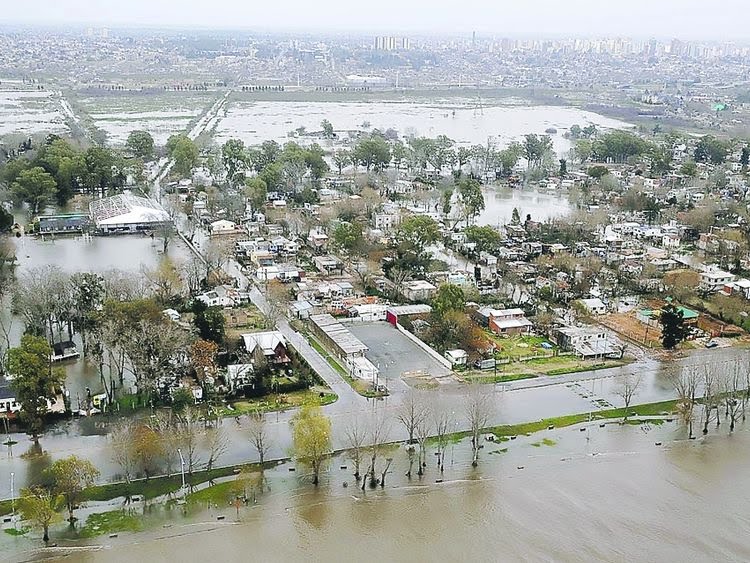
Aerial view of floods in province Buenos Aires for 2012


 --------------------------
2012, 17 August - 2010 August
Sources: infobae.com; infometar.blogspot.com; continental.com.ar
Pakistan SINKING:
/ Floods caused by the current torrential rains have affected close to 3 million people and damaged around 2.2 million acres of crops across the four provinces — killing a total of 369 people so far. According to initial estimates, some 200,000 people are awaiting shelter and relief goods — weeks after heavy flooding destroyed various districts across the country, officials dealing with natural disasters told The Express Tribune on Tuesday. “The estimated damages to infrastructure and private and public property is around Rs250 billion in all four provinces,” revealed a senior official associated with the monitoring cell of the National Disaster Management Authority (NDMA). In comparison, the 2010 floods had damaged crops and other infrastructure amounting over Rs800 billion. /
Thailand SINKING:
/ 15 provinces hit by floods
Fifteen provinces have been hit by floods, affecting more than 210,000 people, Disaster Prevention and Mitigation Department chief Wibul Sanguanpong said on Wednesday. Mr Wibul said there is flooding iin 1,526 villages in 48 districts of the 15 provinces, affecting 214,550 people. The 15 provinces are Tak, Sukhothai, Phitsanulok, Phichit, Nakhon Sawan, Chai Nat, Ang Thong, Ayutthaya, Suphan Buri, Prachin Buri, Sa Kaeo, Nakhon Pathom, Chon Buri, Chachoengsao and Chaiyaphum. Today, the country's major dams are holding altogether 47,589 million cubic metres of water, about 68% of capacity. At this time last year, these dams held a total of 59,549 million cubic metres of water. About 379.21 million cubic metres of water is flowing daily into these dams, which are releasing a total of 97.49 million cubic metres of water per day. /
Cambodia SINKING:
/ Flash floods hit Cambodia's NW province, affecting about 3,000 families. About 3,000 families in Cambodia's Banteay Meanchey province bordering with Thailand have been suffering from floodwaters and local authorities have been advised to be on high alert to respond to the disaster, a senior government official said Wednesday. "About 700 families who are severely affected by the flooding have been evacuated to higher ground," the first Vice-President of the National Committee for Disaster Management (NCDM), Nhim Vanda told Xinhua over telephone. "They are all safe, there is no report of death so far," he said. "Local authorities and Cambodian Red Cross volunteers are on high alert to rescue people in case of more flooding." Vanda said that the flooding has been caused by torrential rains in recent weeks both in Cambodia and in Thailand. /
-------------------------
Pakistan:
Floods have left 369 dead, nearly 3m affected
Floods caused by the current torrential rains have affected close to 3 million people and damaged around 2.2 million acres of crops across the four provinces — killing a total of 369 people so far.
According to initial estimates, some 200,000 people are awaiting shelter and relief goods — weeks after heavy flooding destroyed various districts across the country, officials dealing with natural disasters told The Express Tribune on Tuesday.
“The estimated damages to infrastructure and private and public property is around Rs250 billion in all four provinces,” revealed a senior official associated with the monitoring cell of the National Disaster Management Authority (NDMA).
In comparison, the 2010 floods had damaged crops and other infrastructure amounting over Rs800 billion.
“Over 369 people have lost their lives and 1,168 have been injured during the current floods,” initial estimates prepared by the NDMA stated.
Nearly 2 million acres of crops have been destroyed in all four provinces as well as Azad Kashmir (AJK) and Gilgit-Baltistan (G-B), with Sindh appearing to be the worst-hit province.
Over 12,559 cattle in total have perished and the current flash floods have forced over 600,000 people to take shelter in relief camps.
Sindh
In Sindh, a total of 1.6 million people have been affected and 0.8 million acres of crops have been partially or completely damaged. Around 138 persons have died so far, 600 injured, 0.25 million houses damaged, over 0.3 million acres lands affected and 7,000 cattle perished.
Balochistan
In Balochistan, nearly 80 people have died, 170 injured and 0.2 million houses completely destroyed leaving most of the affected households without shelter. The NDMA, however, is yet to assess the damages of crops and land in the province. Heavy rains have also damaged 40,000 houses, killing 5,056 cattle across the province and the Shahi canals system – a system to water crops in Nasirabad and Jaffarabad – has been destroyed.
Punjab and others
In Punjab, the floods have affected 0.6 million acres out the total 1.14 million acres of crops in various districts and 65 people have so far lost their lives. Nearly 320 have been injured, 503 cattle have perished, 25,453 houses washed away and over one million people affected in floods.
In Khyber-Pakhtunkhwa (K-P) 46 people have lost their lives, 56 injured, and 6,000 houses damaged.
Around 36 people have died in AJK, 40 injured, 2,500 houses damaged.
Five people have lost their lives in the federal capital as well. However, assessment regarding damages of cattle, crops and land is still going on in these areas.
Woes
Meanwhile, Balochistan has again complained to PM Raja Pervaiz Ashraf on Tuesday after not receiving any relief package from Islamabad despite repeated appeals.
“We have repeatedly urged Prime Minister Ashraf to declare all flood-hit districts of the province “calamity-hit” but he never listened to me,” said Federal Minister for Science and Technology Mir Chengez Khan Jamali.
“Today (Tuesday) I called him (Premier Ashraf). He promised to visit Balochistan on Saturday or Sunday to express solidarity with the flood victims,” he said.
Jamali once again appealed to the UN to contribute relief goods for flood victims in areas like Killa Saifullah, Dera Allah Yar Khan, Dera Murad Jamali and Dera Bugti — the worst-affected areas of the current monsoon rains.
Timo Pakkala, who is the UN’s resident coordinator in Pakistan, told The Express Tribune that the government has indicated that they have sufficient resources and would not require international assistance. “We, however, are undertaking an initial rapid assessment with the government in the affected areas to get a better picture.”
http://tribune.com.pk/story/438871/damage-assessment-floods-have-le...
^^^^^^^^^^^^^^^^^^^^^^^^^^^^^^^
Thailand:
15 provinces hit by floods
Fifteen provinces have been hit by floods, affecting more than 210,000 people, Disaster Prevention and Mitigation Department chief Wibul Sanguanpong said on Wednesday.
Mr Wibul said there is flooding iin 1,526 villages in 48 districts of the 15 provinces, affecting 214,550 people. The 15 provinces are Tak, Sukhothai, Phitsanulok, Phichit, Nakhon Sawan, Chai Nat, Ang Thong, Ayutthaya, Suphan Buri, Prachin Buri, Sa Kaeo, Nakhon Pathom, Chon Buri, Chachoengsao and Chaiyaphum.
Today, the country's major dams are holding altogether 47,589 million cubic metres of water, about 68% of capacity. At this time last year, these dams held a total of 59,549 million cubic metres of water.
About 379.21 million cubic metres of water is flowing daily into these dams, which are releasing a total of 97.49 million cubic metres of water per day.
Bhumibol and Sirikit dams are now holding 7,532 and 6,081 million cubic metres of water, or 56% and 64% of their capacity respectively. Today, the two dams are releasing a total of 2.42 million cubic metres of water.
Water in the Chao Phraya River is flowing at 1,748 cubic metres per second through Nakhon Sawan, 1,646 cubic metres per second through the Chao Phraya dam in Chai Nat, and 233 cubic metres per second through Phra Ram 6 dam in Ayutthaya.
If the volume of water running through Chao Phraya dam exceeds 2,500 cubic metres per second, Sapphaya district of Chai Nat and areas on both sides of the Chao Phraya River banks in Sing Buri, Ang Thong, Ayutthaya, as well as Bangkok and surrounding provinces would flood, Mr Wibul said.
http://www.bangkokpost.com/breakingnews/313058/15-provinces-hit-by-...
^^^^^^^^^^^^^^^^^^^^^^^^^
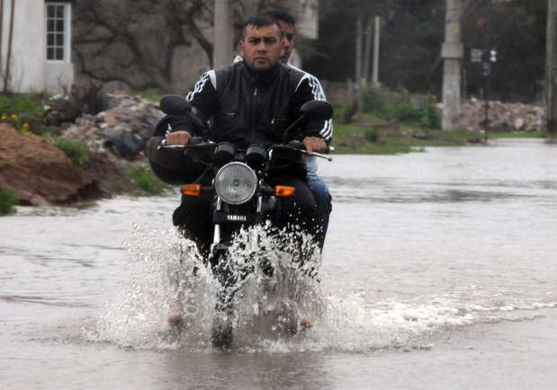
Buenos Aires:
Already by the rising floodwaters of the Rio de la Plata
Sectors Spa Punta Lara, in the district of Ensenada, in Tigre and Quilmes coast were flooded and local firefighters carrying out an operation to evacuate.
Many sections of the coastal avenue impassable in Punta Lara and Quilmes because of the high water river waves hitting the seawall, amid sudestada alert due to strong winds issued by the National Weather Service. For 20 hours is expected peak flood.
The height of the Río de la Plata in the area reaches to 2.40 meters when the normal height is 80 centimeters to one meter and the water rose 200 meters above the town area.
Meanwhile, the National Weather Service forecast worsening of the intensity of the winds that could reach speeds between 60 and 90 mph, with higher gusts, a situation that will continue until tomorrow afternoon with the removal of the current low pressure system.
The Civil Defense director Berisso, Pablo Acosta, said the alert continues the swollen River Plate and predicted that tonight could reach a peak of 3.10 meters.
The operation "is underway, and we have the boats ready to go out and firefighters prepared" for any emergency, he said.
http://www.minutouno.com/notas/262671-ya-hay-zonas-anegadas-la-crec...
^^^^^^^^^^^^^^^^^^^^^^^^^^^
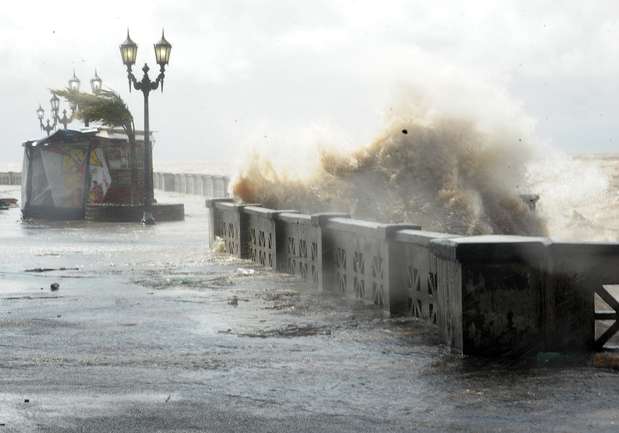
Alert and floods in the coastal zone by sudestada
A powerful sudestada yesterday struck the city of Buenos Aires and the southern and northern suburbs, causing heavy flooding in the Rio de la Plata and the direct impact on the coastal areas of La Plata, Quilmes, Bernal, Ensenada, Tigre and Vicente Lopez. While alert sudestada already ceased, the National Weather Service (NWS) maintains a strong winds alert for Capital, the Rio de la Plata, Buenos Aires and Entre Rios. Meanwhile, the Naval Hydrographic Service reported that afternoon the River Plate was 1.80 meters above its usual height. The peak of the flood occurred last night.
While in the Coastal River waves beating down, the SMN early yesterday launched several high winds alerts for the City, the Rio de la Plata, north of Buenos Aires, the center and southeast of Cordoba, Entre Rios, and the center and south of Santa Fe "The deepening low pressure system will affect the coverage area with winds from the southeast, south gradually rotating at speeds of 40 to 70 mph with gusts" he said. To the river and coastal areas, according to the SMN winds expected up to 85 kilometers per hour. "The speed of the winds begin to decline from late Wednesday, with the displacement of low-pressure system to the southeast," he predicted.
A low pressure system is a region where there has been a rise in hot and humid air from the spiral surface of the Earth. In these regions there are usually clouds and winds. Like in his rise hot air cools the clouds, they thicken and rain often occur. If the pressure is too low, the wind can become storm or hurricane.
Strong southeasterly winds caused the flooding of the Rio de la Plata, before which the Naval Hydrographic Service issued another alert, saying that the river was 1.80 meters on the values of the tide table and, for the first few hours on Wednesday, could overcome at 2.30 meters. Last night, past the 23 the height of the river in the City reached 3 meters, while in La Plata and Quilmes came to 2.90 meters and, somewhat later, in San Fernando and Tigre maximum flood occurred in March, 20 meters.
Tiger was one of the worst affected districts, especially in downtown areas, Villa cream, Talar de Pacheco, and Milberg Corner Tiger Hospital. There was standing water in about 60 of the 1,600 blocks of the district and about 30 streets were flooded, including Lavalle, bordering the river.
In Vicente Lopez, the city closed in the area beneath the streets Melo, Villate, Alberdi Malaver and because they were impassable. "In many blocks cut by prevention, we plan on alert to see what happens during the night, when would be the peak," said Martin Gasulla, director of Civil Defense. One of the hardest hit areas was the port of Olives, where water containment exceeded the railings and reached the coastal restaurants.
In the south, the streets of the waterfront of Quilmes also ended covered with water and several families chose autoevacuarse. During the afternoon, the water level dropped, but there was a new peak at night. "We will continue to bet and working across the waterfront, as we have done from early on," the director of Civil Defense of Quilmes, Nestor Guglielmino.
There were problems in several areas of Punta Lara, in the district of Ensenada, where the water rose 200 meters above the sea and several sections of the Costanera Avenue were impassable. There, the River Plate reached 2.40 meters flood when the normal height between 0.80 and meter.
Coast Guard launched an action plan to assist and evacuate coastal residents, if the river continues to grow. Also decreed alert for the area of the Rio de la Plata and Quilmes prefectures and Dock Sud expected for the dawn of the flood peaks and also the strongest winds.
The SMN had planned rain but the big problem last night the winds were still. Just today, as predicted, would change from strong to moderate, as they were moving the center of low pressure and, with it, the dangerous sudestada.
http://www.clarin.com/sociedad/Alerta-inundaciones-zona-costera-sud...
^^^^^^^^^^^^^^^^^^^^^^^^^^^^^^^^
Cambodia:
Flash floods hit Cambodia's NW province, affecting about 3,000 families
About 3,000 families in Cambodia's Banteay Meanchey province bordering with Thailand have been suffering from floodwaters and local authorities have been advised to be on high alert to respond to the disaster, a senior government official said Wednesday.
"About 700 families who are severely affected by the flooding have been evacuated to higher ground," the first Vice-President of the National Committee for Disaster Management (NCDM), Nhim Vanda told Xinhua over telephone.
"They are all safe, there is no report of death so far," he said. "Local authorities and Cambodian Red Cross volunteers are on high alert to rescue people in case of more flooding."
Vanda said that the flooding has been caused by torrential rains in recent weeks both in Cambodia and in Thailand.
The flash floods have also affected some 500 hectares of rice paddy and 1,200 hectares of cassava crops in the province.
The Ministry of Water Resources and Meteorology on Monday warned of heavy rains throughout this week and said some 13 provinces out of the country's 24 cities and provinces could suffer from flash floods.
Possible flood-hit provinces are Oddar Meanchey, Preah Vihear, Banteay Meanchey, Battambang, Pursat, Kampong Chhnang, Siem Reap, Kampong Thom, Kampong Speu, Takeo, Kandal, Prey Veng and Kampot.
Floods usually hit Cambodia between August and October. Last year, the floods killed at least 250 Cambodian people and affected some 1.4 million people in the country, according to the NCDM.
Moreover, nearly 3,000 km of gravel roads and some 180 km of national roads had been damaged.
The last year's floods cost the country about $521 million.
http://www.globaltimes.cn/content/734081.shtml
^^^^^^^^^^^^^^^^^^^^^^^^^^^^^^^^
Views: 3643
Comment
-
Comment by jorge namour on September 20, 2012 at 1:33am
-
19.09.12
A strong storm paralyzed much of the activity in Uruguay
Hurricane winds reach 150 kilometers per hour. They had to close schools, public offices and malls. Nor ports work.
A great storm, with rain and winds of up to 150 kilometers per hour, has generated in the last few hours several complications in Montevideo and in much of the Uruguayan territory. This forced the closure of schools, banks and shopping, and public offices evacuated. Nor ports operate. According to the weather service, will continue throughout the day.
Dozens of fallen trees, that dragging cables have led many neighborhoods are without electricity or telephone, virios broken, roofs and billboards flown, offices and homes evacuated, and broken traffic lights that have generated chaos in traffic, is only part of it by this time observed in the Uruguayan capital. The good, within a very worrying scenario is that there have been no fatalities.
Unlike temporary remembered August 2005, the weather service did not anticipate and that left several dead and countless damage, this time the population was alerted that there would be very strong winds, so that people and active forces were prepared to face the best.
Anyway firefighters that the imminence of the storm increased its stock of ropes and chainsaws, can not cope in this time attending to the call of hundreds of citizens. The power outage prevents commercial activity: in service stations can not load fuel and supermarkets do not work the cash registers.
Since morning the Municipality of Montevideo, urged people not to travel on the boulevard, due to strong winds and the water, which in some parts, paste against the walls and hits the streets, so many places of the boulevard can not move.
Also, the mayor and the national emergency system advised to avoid unnecessary circulation and remove objects outside houses that could become projectiles.
Several public offices and schools closed their doors, same as banks and shopping. Around noon, in Antel Tower, the tallest building in Montevideo, evacuated staff, motion was perceived top of the building, which broke many windows.
The ports of Montevideo and Colonia presented a bleak picture, and left early to be operational. In Montevideo, inclusive, the tide had dragged two small boats that ran aground near one of the jetties.
In addition, traffic police announced that the country's various routes are cut, because rivers and streams have flooded bridges, so these roads have become impassable. Carrasco Airport was operating, and so far had no anticipation of closing.
Continue...
http://translate.google.com.ar/translate?sl=es&tl=en&js=n&a...
© 2025 Created by 0nin2migqvl32.
Powered by
![]()
You need to be a member of Earth Changes and the Pole Shift to add comments!
Join Earth Changes and the Pole Shift