
:quality(70)/cloudfront-eu-central-1.images.arcpublishing.com/irishtimes/U3AEYVLLVQOPFT5ZV6H7ZXMXLE.jpg)
:quality(70)/cloudfront-eu-central-1.images.arcpublishing.com/irishtimes/ZALTB4GZCQKG5PWKFBKM3VSMQE.jpg)


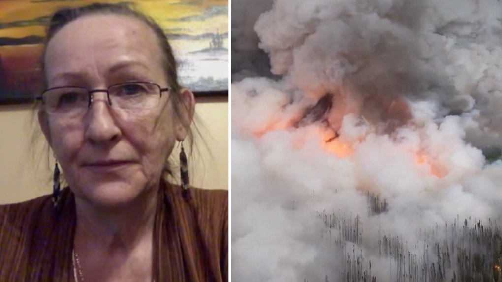
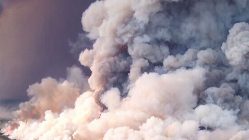
One of the wildfires burning west of Yellowknife is approximately 165,000 hectares, more than 600 square miles, and inching closer to the community and main highway, according to Mike Gibbins, who manages communications for Municipal Affairs Minister Shane Thompson’s office.
“We’re all tired of the word unprecedented, yet there is no other way to describe this situation in the Northwest Territories,” Premier Caroline Cochrane said in a statement Wednesday night.
“Residents living along the Ingraham Trail, in Dettah, Kam Lake, Grace Lake and Engle Business District are currently at highest risk and should evacuate as soon as possible. Other residents have until noon on Friday, August 18, 2023 to evacuate,” Northwest Territories officials said in a news release Wednesday.
The community of N’dilo is also under an evacuation order, officials said in the release. Those unable to leave by vehicle can register for an air evacuation, officials said.
“If you are able to evacuate by road, obey all warning signs, emergency management officials, traffic control devices and posted speed limits,” Cochrane added. “Do not make any rash decisions that can put other people in danger.”
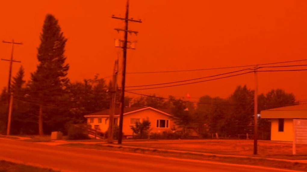
Those driving out of the Yellowknife area face a potentially perilous journey through heavy smoke and fire. “There were patches of flames on each side as we drove through,” Nadia Byrne told CNN, calling her evacuation the most terrifying experience she’s had.
Byrne, along with four friends and their dogs, left Yellowknife Tuesday evening and struggled to see – and breathe – while driving.
“We hit a patch where we couldn’t see any of the lines on the road. That lasted 45 minutes,” she said. “We had our N95s on and could barely breathe and our chest and lungs hurt.”
The group made it to their destination safely the next morning, she said.
“We find ourselves in a crisis situation and our government is using every tool available to assist,” Thompson said.
Thompson declared an emergency for the entire territory on Tuesday, which will allow officials “to access and deploy resources so that we can continue our work to protect residents and communities in a more efficient manner,” he said.
The mayor of Yellowknife also issued a local state of emergency as the fires approached. The flames were less than 10 miles from the town Wednesday evening, officials said.
The new evacuation orders come as much of the South Slave region – including the town of Hay River – was placed under an evacuation order over the weekend. Roads out of Hay River to the Alberta border and west to Yellowknife were also closed, town officials said in a Facebook post.
“The situation has changed quickly. Strong winds have blown the fire within 10 km (6 miles) of the community. It is anticipated the fire will reach Hay River this evening,” Northwest Territories Fire said in a Facebook update Wednesday evening. “Crews that were in the path of the fire are pulling off for their own safety and are re-positioning to assist in other areas.”
A team from Alberta has been deployed to the Hay River area to lay fire retardant to help stop the fire from spreading, according to Northwest Territories Fire, a Canadian government agency.
“Sprinklers and structure protections are in place and turned on, other operations will continue work when conditions allow,” the agency added.
Evacuees from South Slave were initially advised to go to a reception center in Grande Prairie, but the government of the Northwest Territories has since rerouted them to a new center in St. Albert, Alberta.
In terms of the fires’ impact on communities in the Northwest Territories, “this has been the worst wildfire season in NWT history,” said Gibbins, adding that approximately 65% of the NWT population has been impacted by evacuations as a result of wildfires this season.
British Columbia prepares for potentially catastrophic days ahead
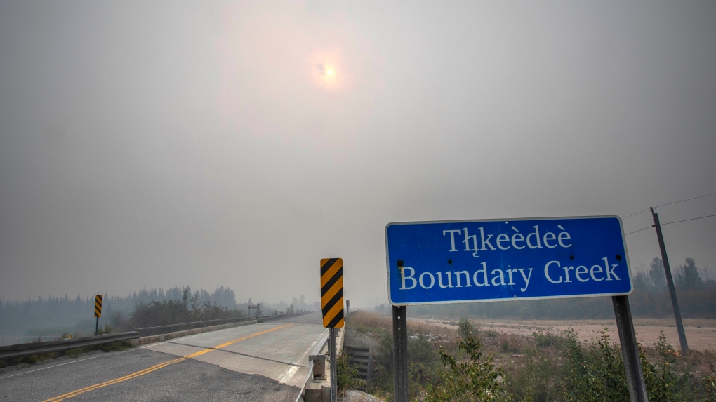
There are over 360 active fires burning in neighboring British Columbia, where officials expect fire conditions to worsen as heat and lightning are forecast to combine over the next few days.
“This weather event has the potential to be the most challenging 24 to 48 hours of the summer from a fire perspective,” Cliff Chapman, of the British Columbia Fire Wildfire Service, said in a Thursday news conference. “We are expecting significant growth, and we are expecting our resources to be challenged.”
Chapman warned that high pressure has led to record-breaking heat and that lightning is being forecast, which he said has been the “primary ignition source for new fires.”
The high-pressure air also causes dry winds, which contribute to extreme fire behavior, according to the BC Wildfire Service. These weather conditions exacerbate low fuel moisture in dead vegetation, which allows fires to start easily and spread rapidly.
These weather conditions also result in live vegetation, including peoples’ lawns and trees, to start yellowing – not because fall is approaching but because the plants are experiencing extreme drought conditions.
This is dangerous because it results in additional live vegetation becoming available for burning, increasing the risk of the fires getting bigger and spreading further, said Neal McLaughlin of the BC Wildfire Service.
“BC Wildfire Service is concerned about the upcoming ridge breakdown, and what that could mean in terms of fire behavior,” McLaughlin said. “We’d like to alert the public that there could be rapidly evolving fire behavior and fire behavior that could spread very quickly across the landscape.”
US under air quality alert
The fires burning in Canada have once again led to harmful air quality in the US, with the Minnesota Pollution Control issuing an air quality alert for Thursday and Friday.
“Heavy ground-level smoke from wildfires in the Northwest Territories of Canada is moving south across central Canada and towards Minnesota on Wednesday,” the National Weather Service warned. “A strong cold front will bring this smoke across the entire state on Thursday.”
Smoke could reach the Minnesota-Canadian border around midnight Thursday, and then possibly move over the Twin Cities around noon and southern Minnesota by 3 p.m. Thursday, the weather service said.
Air quality has the potential to reach the Purple or Very Unhealthy category for several hours in eastern Minnesota, the weather service said.
Sensitive groups, such as people with lung or heart disease, the elderly and children are urged to avoid prolonged or heavy exertion and the general public is being told to limit outdoor activity.
“Smoke will linger across the eastern half of the state on Friday and fine particle levels will continue to be high for most of the day,” the weather service said. “Winds will become southerly Friday afternoon and smoke will begin to retreat away from the state and disperse. Air quality should improve below alert levels by the end of the day on Friday.
In Canada, the Minister of National Defense Bill Blair on Tuesday mobilized the Canadian Armed Forces to provide firefighting personnel, airlift resources, and logistical support to the Northwest Territories.
“We stand with the people of the Northwest Territories as they experience their worst fire season on record, and I am confident that our military personnel will do their utmost to assist their fellow Canadians,” Blair said in a statement.
Canadian Prime Minister Justin Trudeau said he was in communication with Cochrane on Wednesday.
“To the people of the Northwest Territories: We’re here for you. We’ve mobilized Canadian Armed Forces members, and we’ll continue to provide whatever resources are needed. I spoke about that with Premier Caroline Cochrane today – and reaffirmed our commitment to assisting however we can,” Trudeau said in a social media post.
Trudeau also met with officials on Thursday to discuss the ongoing wildfires and said that there would be no tolerance for any attempt to escalate prices on things like airfare and essential goods.
You need to be a member of Earth Changes and the Pole Shift to add comments!
Join Earth Changes and the Pole Shift